ATL: ETA - Models

Moderator: S2k Moderators

Message
Author
Keldeo1997
Category 2
Category 2
Posts: 637
Joined: Fri Oct 11, 2019 11:35 pm

Re: ATL: ETA - Models

#601 Postby Keldeo1997 » Sun Nov 01, 2020 6:07 pm

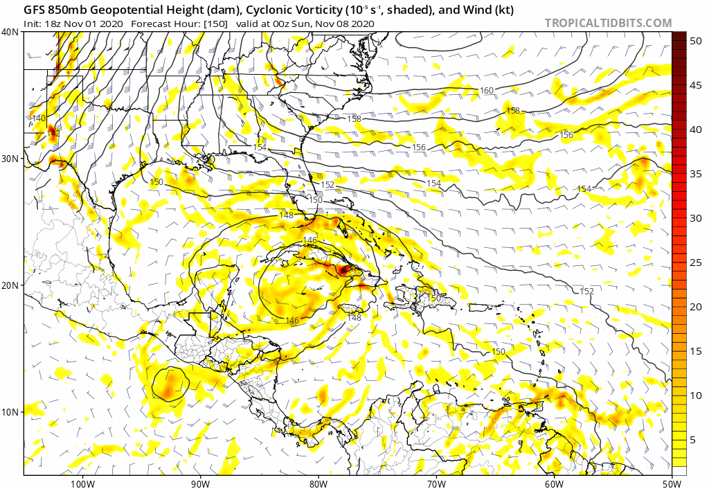
aspen wrote:18z HWRF has extremely rapid intensification...in fact, a little too much RI. That’s a Cat 4 by late tomorrow morning. That’s not happening.


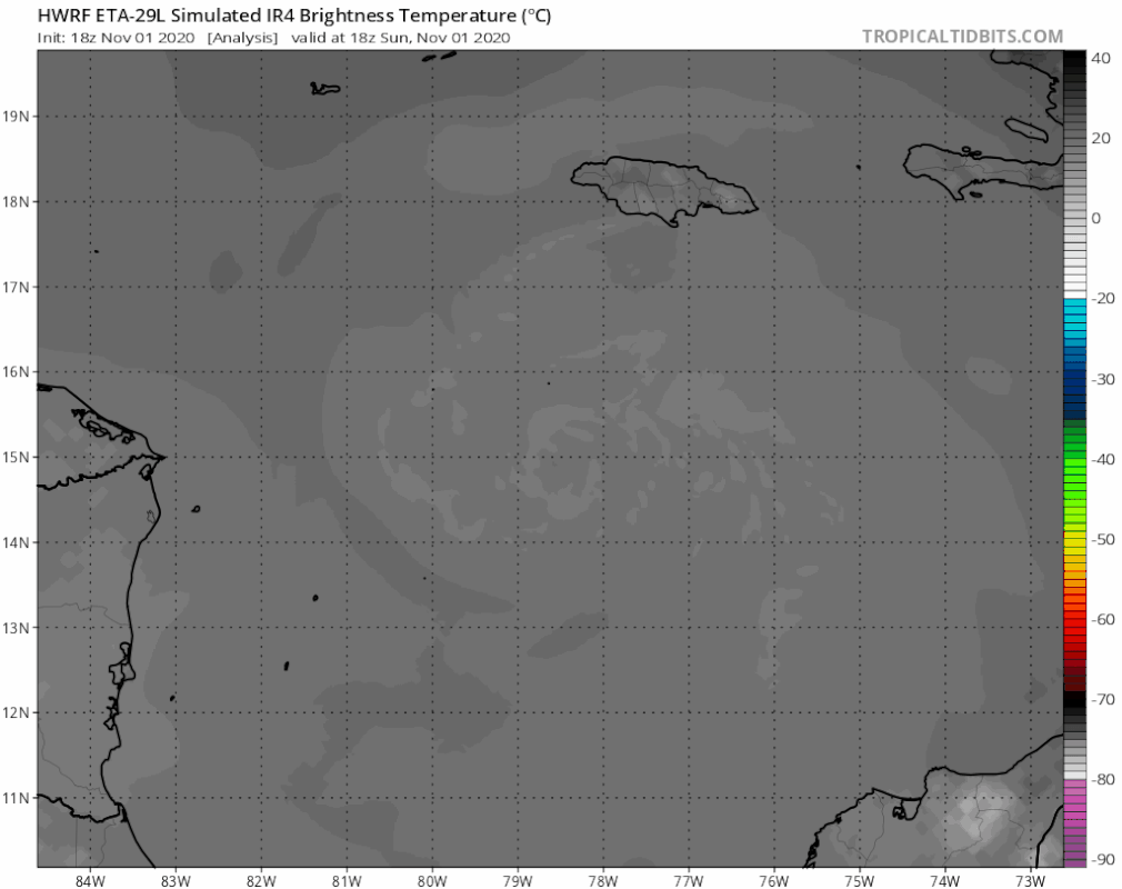
The way IR looking right now that may not be to crazy. HWRF Initialized pretty good showing the open eyewall to the South

Image

Image
4 likes   

User avatar
MetroMike
Category 4
Category 4
Posts: 952
Joined: Sun Aug 29, 2004 8:13 pm
Location: Tampa Bay
Contact:

Re: ATL: ETA - Models

#602 Postby MetroMike » Sun Nov 01, 2020 6:09 pm

gatorcane wrote:18Z GFS long-range with a new solution:

https://i.postimg.cc/59wsVxYy/gfs-z850-vort-watl-fh150-288.gif


We thought it would be shunted off to the East, but no its coming back to Cuba?
Last edited by MetroMike on Sun Nov 01, 2020 6:11 pm, edited 1 time in total.
1 likes   

User avatar
Nimbus
Category 5
Category 5
Posts: 5300
Joined: Mon Jul 19, 2004 10:54 am

Re: ATL: ETA - Models

#603 Postby Nimbus » Sun Nov 01, 2020 6:11 pm

18Z HMON dives Eta into Honduras but lots of circulation creating shear lift in the Bay of Honduras so even if the original center dissipates there could still be low surface pressure spreading over the gulf where a new center could form in 4 or 5 days. 18Z HWRF portrayed a center jump like that last night at the 93 hour mark when the old center was weakening inland near the border of Nicaragua.
0 likes   

supercane4867
Category 5
Category 5
Posts: 4966
Joined: Wed Nov 14, 2012 10:43 am

Re: ATL: ETA - Models

#604 Postby supercane4867 » Sun Nov 01, 2020 6:28 pm

HWRF clearly wants to replicate a Typhoon Goni in the Caribbean.

Image
5 likes   

LarryWx
S2K Supporter
S2K Supporter
Posts: 6305
Joined: Sun Sep 07, 2003 2:04 pm
Location: GA

Re: ATL: ETA - Models

#605 Postby LarryWx » Sun Nov 01, 2020 6:43 pm

supercane4867 wrote:HWRF clearly wants to replicate a Typhoon Goni in the Caribbean.

https://i.imgur.com/hpNCUu4.png


And note that despite it being every bit as strong as the 12Z (930s), it is much further SW than that outlier 12Z run and near the 6Z and 0Z.
0 likes   
Personal Forecast Disclaimer:
The posts in this forum are NOT official forecasts and should not be used as such. They are just the opinion of the poster and may or may not be backed by sound meteorological data. They are NOT endorsed by any professional institution or storm2k.org. For official information, please refer to the NHC and NWS products.

tolakram
Admin
Admin
Posts: 20009
Age: 62
Joined: Sun Aug 27, 2006 8:23 pm
Location: Florence, KY (name is Mark)

Re: ATL: ETA - Models

#606 Postby tolakram » Sun Nov 01, 2020 6:46 pm

Trend is still to hug the coast. Looks like steering completely breaks down with Eta drifting off the cost before moving west/nw.

Image
0 likes   
M a r k
- - - - -
Join us in chat: Storm2K Chatroom Invite. Android and IOS apps also available.

The posts in this forum are NOT official forecasts and should not be used as such. Posts are NOT endorsed by any professional institution or STORM2K.org. For official information and forecasts, please refer to NHC and NWS products.

User avatar
SFLcane
S2K Supporter
S2K Supporter
Posts: 10163
Age: 47
Joined: Sat Jun 05, 2010 1:44 pm
Location: Lake Worth Florida

Re: ATL: ETA - Models

#607 Postby SFLcane » Sun Nov 01, 2020 6:49 pm

18z GEFS still quite busy near the Florida peninsula.
0 likes   

tolakram
Admin
Admin
Posts: 20009
Age: 62
Joined: Sun Aug 27, 2006 8:23 pm
Location: Florence, KY (name is Mark)

Re: ATL: ETA - Models

#608 Postby tolakram » Sun Nov 01, 2020 6:57 pm

HWRF does move it well inland again.

Image
0 likes   
M a r k
- - - - -
Join us in chat: Storm2K Chatroom Invite. Android and IOS apps also available.

The posts in this forum are NOT official forecasts and should not be used as such. Posts are NOT endorsed by any professional institution or STORM2K.org. For official information and forecasts, please refer to NHC and NWS products.

User avatar
aspen
Category 5
Category 5
Posts: 8818
Joined: Sat Oct 12, 2019 7:10 pm
Location: Connecticut, USA

Re: ATL: ETA - Models

#609 Postby aspen » Sun Nov 01, 2020 6:57 pm

Deepest run yet.
Image
18z HWRF wants a pinhole eye by the time recon arrives at 06z tomorrow morning. Since the pink <-80C CDO has formed and microwave is starting to show the eyewall close off into a pinhole, perhaps this is possible.
Image
3 likes   
Irene '11 Sandy '12 Hermine '16 5/15/2018 Derecho Fay '20 Isaias '20 Elsa '21 Henri '21 Ida '21

I am only a meteorology enthusiast who knows a decent amount about tropical cyclones. Look to the professional mets, the NHC, or your local weather office for the best information.

LarryWx
S2K Supporter
S2K Supporter
Posts: 6305
Joined: Sun Sep 07, 2003 2:04 pm
Location: GA

Re: ATL: ETA - Models

#610 Postby LarryWx » Sun Nov 01, 2020 6:58 pm

18Z HWRF is absolutely terrible for Honduras and N Nicaragua.
0 likes   
Personal Forecast Disclaimer:
The posts in this forum are NOT official forecasts and should not be used as such. They are just the opinion of the poster and may or may not be backed by sound meteorological data. They are NOT endorsed by any professional institution or storm2k.org. For official information, please refer to the NHC and NWS products.

User avatar
Spacecoast
Category 2
Category 2
Posts: 758
Joined: Thu Aug 31, 2017 2:03 pm

Re: ATL: ETA - Models

#611 Postby Spacecoast » Sun Nov 01, 2020 7:01 pm

Big pile of Spaghetti for Sunday night.
All 32 members of GEFS + All 51 Members of ECMF + All deterministic + All Consensus guidance + NHC Official
(white is consensus (of Consensus))
Choose your favorite strand. My only observation is that Eta may find it difficult to rise above 28N
Image
5 likes   

supercane4867
Category 5
Category 5
Posts: 4966
Joined: Wed Nov 14, 2012 10:43 am

Re: ATL: ETA - Models

#612 Postby supercane4867 » Sun Nov 01, 2020 7:03 pm

18z GFS fantasy land lol

Image
11 likes   

User avatar
Nimbus
Category 5
Category 5
Posts: 5300
Joined: Mon Jul 19, 2004 10:54 am

Re: ATL: ETA - Models

#613 Postby Nimbus » Sun Nov 01, 2020 7:21 pm

18Z HWRF run makes the center jump at 90 hours this run.
So maybe something to track after the CA crisis if the NHC gets on board later.
0 likes   

User avatar
CyclonicFury
Category 5
Category 5
Posts: 2025
Age: 26
Joined: Sun Jul 02, 2017 12:32 pm
Location: NC
Contact:

Re: ATL: ETA - Models

#614 Postby CyclonicFury » Sun Nov 01, 2020 7:40 pm

SHIPS Prob RI for 20kt/ 12hr RI threshold= 32% is 6.4 times climatological mean ( 5.0%)
SHIPS Prob RI for 25kt/ 24hr RI threshold= 75% is 6.9 times climatological mean (10.9%)
SHIPS Prob RI for 30kt/ 24hr RI threshold= 53% is 7.7 times climatological mean ( 6.9%)
SHIPS Prob RI for 35kt/ 24hr RI threshold= 40% is 10.2 times climatological mean ( 3.9%)
SHIPS Prob RI for 40kt/ 24hr RI threshold= 27% is 11.0 times climatological mean ( 2.5%)
SHIPS Prob RI for 45kt/ 36hr RI threshold= 56% is 12.1 times climatological mean ( 4.6%)
SHIPS Prob RI for 55kt/ 48hr RI threshold= 41% is 8.9 times climatological mean ( 4.6%)
SHIPS Prob RI for 65kt/ 72hr RI threshold= 51% is 9.7 times climatological mean ( 5.2%)
2 likes   
NCSU B.S. in Meteorology Class of 2021. Tropical weather blogger at http://www.cyclonicfury.com. My forecasts and thoughts are NOT official, for official forecasts please consult the National Hurricane Center.

User avatar
gatorcane
S2K Supporter
S2K Supporter
Posts: 23691
Age: 47
Joined: Sun Mar 13, 2005 3:54 pm
Location: Boca Raton, FL

Re: ATL: ETA - Models

#615 Postby gatorcane » Sun Nov 01, 2020 7:43 pm

Saved HWRF loop:

Image
0 likes   

Shell Mound
Category 5
Category 5
Posts: 2434
Age: 32
Joined: Thu Sep 07, 2017 3:39 pm
Location: St. Petersburg, FL → Scandinavia

Re: ATL: ETA - Models

#616 Postby Shell Mound » Sun Nov 01, 2020 7:59 pm


Given the current coordinates and forward speed, plus the really strong ridging to the northwest, I’m feeling numb for Central America right now.
0 likes   
CVW / MiamiensisWx / Shell Mound
The posts in this forum are NOT official forecasts and should not be used as such. They are just the opinion of the poster and may or may not be backed by sound meteorological data. They are NOT endorsed by any professional institution or STORM2K. For official information, please refer to products from the NHC and NWS.

supercane4867
Category 5
Category 5
Posts: 4966
Joined: Wed Nov 14, 2012 10:43 am

Re: ATL: ETA - Models

#617 Postby supercane4867 » Sun Nov 01, 2020 8:20 pm

HWRF end of the run shows re-intensification from TD to TS

Image
2 likes   

TheStormExpert

Re: ATL: ETA - Models

#618 Postby TheStormExpert » Sun Nov 01, 2020 8:34 pm

supercane4867 wrote:18z GFS fantasy land lol

https://i.imgur.com/19a7Rl8.gif

Looks like a certain pre-Zeta run from the GFS-P.
0 likes   

RL3AO
Moderator-Pro Met
Moderator-Pro Met
Posts: 16308
Joined: Thu Jun 14, 2007 10:03 pm
Location: NC

Re: ATL: ETA - Models

#619 Postby RL3AO » Sun Nov 01, 2020 8:44 pm

Some of these model runs are a good reminder that some crazy stuff can happen with TC movement in November.
4 likes   

crimi481
Category 2
Category 2
Posts: 602
Joined: Thu Sep 09, 2004 4:47 pm

Re: ATL: ETA - Models

#620 Postby crimi481 » Sun Nov 01, 2020 8:48 pm

Well the models narrowed it down to somewhere between Veracruz and the Bahamas. lol. stay tuned
5 likes   


Return to “2020”

Who is online

Users browsing this forum: No registered users and 2 guests