
WPAC: GONI - Post-Tropical
Moderator: S2k Moderators
-
1900hurricane

- Category 5

- Posts: 6063
- Age: 34
- Joined: Fri Feb 06, 2015 12:04 pm
- Location: Houston, TX
- Contact:
Re: WPAC: GONI - Typhoon
You can see the "inner eye" wobbling around inside the new larger eye on a loop.
7 likes
Contract Meteorologist. TAMU & MSST. Fiercely authentic, one of a kind. We are all given free will, so choose a life meant to be lived. We are the Masters of our own Stories.
Opinions expressed are mine alone.
Follow me on Twitter at @1900hurricane : Read blogs at https://1900hurricane.wordpress.com/
Opinions expressed are mine alone.
Follow me on Twitter at @1900hurricane : Read blogs at https://1900hurricane.wordpress.com/

Re: WPAC: GONI - Typhoon
Looking a little better last few frames. WMG in the eye may reappear soon

0 likes
Very useful information on the Dvorak Technique --
https://severe.worldweather.wmo.int/TCF ... kBeven.pdf
https://severe.worldweather.wmo.int/TCF ... kBeven.pdf
-
dexterlabio
- Category 5
- Posts: 3503
- Joined: Sat Oct 24, 2009 11:50 pm
Re: WPAC: GONI - Typhoon
1900hurricane wrote:You can see the "inner eye" wobbling around inside the new larger eye on a loop.
https://i.imgur.com/HdZTJJr.gif
Big question here is will it have time to clear out that larger eye. Looks like a strike to Catanduanes island within the next 8 hours is inevitable.
0 likes
Personal Forecast Disclaimer:
The posts in this forum are NOT official forecast and should not be used as such. They are just the opinion of the poster and may or may not be backed by sound meteorological data. They are NOT endorsed by any professional institution or storm2k.org. For official information, please refer to the NHC and NWS products.
The posts in this forum are NOT official forecast and should not be used as such. They are just the opinion of the poster and may or may not be backed by sound meteorological data. They are NOT endorsed by any professional institution or storm2k.org. For official information, please refer to the NHC and NWS products.
Re: WPAC: GONI - Typhoon
WMG returns and the CDG ring is thicker. Not sure if the width requirements have been met, but it's damn close. Basically a T 8.0

0 likes
Very useful information on the Dvorak Technique --
https://severe.worldweather.wmo.int/TCF ... kBeven.pdf
https://severe.worldweather.wmo.int/TCF ... kBeven.pdf
-
euro6208
Re: WPAC: GONI - Typhoon
Catanduanes.
WDPN31 PGTW 311500
MSGID/GENADMIN/JOINT TYPHOON WRNCEN PEARL HARBOR HI//
SUBJ/PROGNOSTIC REASONING FOR SUPER TYPHOON 22W (GONI)
WARNING NR 015//
RMKS/
1. FOR METEOROLOGISTS.
2. 6 HOUR SUMMARY AND ANALYSIS.
SUPER TYPHOON (STY) 22W (GONI), LOCATED APPROXIMATELY 321 NM
EAST OF MANILA, PHILIPPINES, HAS TRACKED WEST-SOUTHWESTWARD AT 12
KNOTS OVER THE PAST SIX HOURS. ANIMATED ENHANCED INFRARED
SATELLITE IMAGERY (EIR) SHOWS A COMPACT, DENSE, AND SYMMETRICAL
SYSTEM WITH FEEDER BANDS TIGHTLY WRAPPED AND TUCKED INTO THE
CENTRAL CONVECTION THAT HAS MAINTAINED A 9-NM SHARPLY-OUTLINED
EYE. OUTSIDE THE PINHOLE EYE IS A CLOUD-FREE MOAT THAT SEPARATES
IT FROM AN EVOLVING 35-NM SECONDARY OUTER EYEWALL, PRELUDE TO AN
EYEWALL REPLACEMENT CYCLE (ERC). THE INITIAL POSITION IS PLACED
WITH HIGH CONFIDENCE BASED ON THE EYE IN THE EIR LOOP THAT
PERFECTLY LINED UP WITH A WELL-DEFINED MICROWAVE EYE FEATURE
IN THE 311000Z SSMIS 37GHZ IMAGE. A CORRESPONDING 31100Z IRBD
IMAGE STACKS VERTICALLY WITH THE MICROWAVE EYE, INDICATING ZERO
TILT AND LIGHT VERTICAL WIND SHEAR (VWS). THE INITIAL INTENSITY OF
155 KTS IS BASED ON HIGH END OF 311140Z ADT ESTIMATE OF 152KTS AND
CONGRUENT PGTW/RJTD DVORAK CURRENT INTENSITY ESTIMATES OF
T7.5/155KTS. UPPER LEVEL ANALYSIS INDICATES A VERY FAVORABLE
ENVIRONMENT WITH LOW (05-10KT) VWS AND ROBUST RADIAL OUTFLOW.
ADDITIONALLY, SEA SURFACE TEMPERATURES IN THE PHILIPPINE SEA AT
30-31C ARE VERY CONDUCIVE. THE CYCLONE IS TRACKING ALONG THE
SOUTHERN PERIPHERY OF A DEEP-LAYERED SUBTROPICAL RIDGE (STR) TO
THE NORTHWEST.
3. FORECAST REASONING.
A. NO CHANGE TO THE FORECAST PHILOSOPHY SINCE THE PREVIOUS
PROGNOSTIC REASONING MESSAGE.
B. THE STR WILL SLIGHTLY WEAKEN AND DRIVE STY 22W ON A FLATTER
WESTWARD TRAJECTORY, MAKE LANDFALL OVER CENTRAL LUZON JUST AROUND
TAU 12, TRACK JUST SOUTH OF MANILA, AND EXIT INTO THE SOUTH CHINA
SEA (SCS) BY TAU 30. THE ENVIRONMENT WILL REMAIN FAVORABLE IN THE
NEAR TERM. HOWEVER, THE ANTICIPATED ERC WILL CAUSE A SLIGHT AND
GRADUAL WEAKENING TO 135KTS BY TAU 12, ALBEIT STILL AT SUPER
TYPHOON INTENSITY. AFTERWARD, INTERACTION WITH THE RUGGED TERRAIN
WILL CAUSE SIGNIFICANT DECAY AND WEAKEN THE SYSTEM TO 75KTS BY TAU
36 AFTER IT EXITS INTO THE SCS. AFTER TAU 36, STY 22W WILL STEADILY
WEAKEN TO 55KTS BY TAU 72 DUE TO INCREASED VWS (20-25KTS).
NUMERICAL MODELS REMAIN IN TIGHT AGREEMENT, LENDING HIGH CONFIDENCE
IN THIS PORTION OF THE JTWC FORECAST TRACK THAT IS LAID NEAR THE
MULTI-MODEL CONSENSUS.
C. BEYOND TAU 72, STY GONI WILL CONTINUE WESTWARD UNDER THE
SAME STR, MAKING A SECONDARY AND FINAL LANDFALL OVER CENTRAL
VIETNAM SOUTH OF DA NANG AROUND TAU 108. THE SYSTEM WILL CONTINUE
TO GRADUALLY WEAKEN DUE TO THE MODERATE (20-25KT) VWS, AND AFTER
LANDFALL, RAPID WEAKENING WITH THE ADDITION OF FRICTIONAL EFFECTS
FROM THE TERRAIN. BY TAU 120, THE SYSTEM WILL BE REDUCED TO 35KTS.
NAVGEM DIVERGES TO THE RIGHT OF THE MAIN CLUSTER OF NUMERICAL
MODELS AND JGSM TO THE LEFT, THEREBY OFFSETTING EACH OTHER. IN
VIEW OF THIS, THERE IS HIGH CONFIDENCE IN THE EXTENDED PORTION OF
THE JTWC TRACK FORECAST THAT IS LAID IN THE MIDDLE OF THE MAIN
CLUSTER.//
NNNN
0 likes

Re: WPAC: GONI - Typhoon
Wow

0 likes
ヤンデレ女が寝取られるているのを見たい!!!
ECMWF ensemble NWPAC plots: https://ecmwfensnwpac.imgbb.com/
Multimodel NWPAC plots: https://multimodelnwpac.imgbb.com/
GFS Ensemble NWPAC plots (16 & 35 day forecast): https://gefsnwpac.imgbb.com/
Plots updated automatically
ECMWF ensemble NWPAC plots: https://ecmwfensnwpac.imgbb.com/
Multimodel NWPAC plots: https://multimodelnwpac.imgbb.com/
GFS Ensemble NWPAC plots (16 & 35 day forecast): https://gefsnwpac.imgbb.com/
Plots updated automatically
Re: WPAC: GONI - Typhoon
Width requirements are now met for a CDG ring. However, the erc is ongoing and not allowing for a consistent WMG eye, thus preventing a consistent T8.0. It had it for about 10 minutes, but is having trouble maintaining the 8.0

0 likes
Very useful information on the Dvorak Technique --
https://severe.worldweather.wmo.int/TCF ... kBeven.pdf
https://severe.worldweather.wmo.int/TCF ... kBeven.pdf
Re: WPAC: GONI - Typhoon
Ring thickness

0 likes
Very useful information on the Dvorak Technique --
https://severe.worldweather.wmo.int/TCF ... kBeven.pdf
https://severe.worldweather.wmo.int/TCF ... kBeven.pdf
-
1900hurricane
- Category 5
- Posts: 6063
- Age: 34
- Joined: Fri Feb 06, 2015 12:04 pm
- Location: Houston, TX
- Contact:
Re: WPAC: GONI - Typhoon
2 likes
Contract Meteorologist. TAMU & MSST. Fiercely authentic, one of a kind. We are all given free will, so choose a life meant to be lived. We are the Masters of our own Stories.
Opinions expressed are mine alone.
Follow me on Twitter at @1900hurricane : Read blogs at https://1900hurricane.wordpress.com/
Opinions expressed are mine alone.
Follow me on Twitter at @1900hurricane : Read blogs at https://1900hurricane.wordpress.com/

Re: WPAC: GONI - Typhoon
Do you have a full shot of Goni with that IR filter?
0 likes
Irene '11 Sandy '12 Hermine '16 5/15/2018 Derecho Fay '20 Isaias '20 Elsa '21 Henri '21 Ida '21
I am only a meteorology enthusiast who knows a decent amount about tropical cyclones. Look to the professional mets, the NHC, or your local weather office for the best information.
I am only a meteorology enthusiast who knows a decent amount about tropical cyclones. Look to the professional mets, the NHC, or your local weather office for the best information.
-
ManilaTC

- WesternPacificWeather.com

- Posts: 593
- Age: 47
- Joined: Mon Oct 26, 2009 5:13 am
- Location: Mandaluyong City, Philippines
- Contact:
Re: WPAC: GONI - Typhoon
Its trying to clear an eye almost the size of Catanduanes Island...
0 likes
The above post is NOT official and should not be used as such. It is my opinion and may or may not be backed by sound meteorological data. It is not endorsed by any professional institution or storm2k.org. Please refer to your official national weather agency.
WEB http://goo.gl/JDiKXB | FB https://goo.gl/N5sIle | @ManilaTC
WEB http://goo.gl/JDiKXB | FB https://goo.gl/N5sIle | @ManilaTC
Re: WPAC: GONI - Typhoon
aspen wrote:
Do you have a full shot of Goni with that IR filter?

3 likes
Very useful information on the Dvorak Technique --
https://severe.worldweather.wmo.int/TCF ... kBeven.pdf
https://severe.worldweather.wmo.int/TCF ... kBeven.pdf
Re: WPAC: GONI - Typhoon
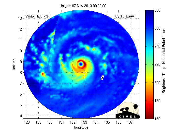
Goni
Haiyan

Haiyan
3 likes
Very useful information on the Dvorak Technique --
https://severe.worldweather.wmo.int/TCF ... kBeven.pdf
https://severe.worldweather.wmo.int/TCF ... kBeven.pdf
Re: WPAC: GONI - Typhoon
It's back to 158 knots 
2020OCT31 114000 7.4 910.3 152.0 7.4 7.6 7.6 NO LIMIT OFF OFF OFF OFF 12.12 -80.82 EYE 12 IR 54.0 14.21 -126.49 ARCHER HIM-8 23.4
2020OCT31 121000 7.4 910.3 152.0 7.4 7.3 7.3 NO LIMIT OFF OFF OFF OFF -11.26 -81.37 EYE 11 IR 54.0 14.21 -126.38 ARCHER HIM-8 23.5
2020OCT31 124000 7.4 910.3 152.0 7.4 7.8 7.8 NO LIMIT OFF OFF OFF OFF 13.03 -82.03 EYE 12 IR 54.0 14.10 -126.20 ARCHER HIM-8 23.5
2020OCT31 131000 7.4 911.8 152.0 7.4 7.5 7.5 NO LIMIT OFF OFF OFF OFF -3.67 -82.23 EYE 10 IR 54.0 14.11 -126.02 ARCHER HIM-8 23.7
2020OCT31 133000 7.5 908.7 155.0 7.5 7.8 7.8 NO LIMIT OFF OFF OFF OFF 12.15 -82.05 EYE 12 IR 54.0 14.05 -125.97 ARCHER HIM-8 23.7
2020OCT31 141000 7.5 908.7 155.0 7.5 7.4 7.4 NO LIMIT OFF OFF OFF OFF -9.32 -82.07 EYE 9 IR 54.0 14.03 -125.76 ARCHER HIM-8 23.8
2020OCT31 143000 7.6 905.6 158.0 7.6 7.8 7.8 NO LIMIT OFF OFF OFF OFF 16.23 -82.27 EYE 11 IR 54.0 13.95 -125.72 ARCHER HIM-8 23.8
0 likes
ヤンデレ女が寝取られるているのを見たい!!!
ECMWF ensemble NWPAC plots: https://ecmwfensnwpac.imgbb.com/
Multimodel NWPAC plots: https://multimodelnwpac.imgbb.com/
GFS Ensemble NWPAC plots (16 & 35 day forecast): https://gefsnwpac.imgbb.com/
Plots updated automatically
ECMWF ensemble NWPAC plots: https://ecmwfensnwpac.imgbb.com/
Multimodel NWPAC plots: https://multimodelnwpac.imgbb.com/
GFS Ensemble NWPAC plots (16 & 35 day forecast): https://gefsnwpac.imgbb.com/
Plots updated automatically
-
euro6208
Re: WPAC: GONI - Typhoon
Basically a high end F3 low end F4 tornado about to come through...but over a larger area and longer time span.
0 likes
-
Meteophile
- Tropical Depression

- Posts: 50
- Joined: Tue May 12, 2020 3:38 pm
Re: WPAC: GONI - Typhoon
The reason why haiyan had this abnormally thick cdo is maybe the growing outer eyewall we can see on mw:
Goni seems to have a part of the feature on its western side, the rest of the cdo is less thick, but still thick because the eyewall itself is thick.
0 likes
-
1900hurricane
- Category 5
- Posts: 6063
- Age: 34
- Joined: Fri Feb 06, 2015 12:04 pm
- Location: Houston, TX
- Contact:
Re: WPAC: GONI - Typhoon

4 likes
Contract Meteorologist. TAMU & MSST. Fiercely authentic, one of a kind. We are all given free will, so choose a life meant to be lived. We are the Masters of our own Stories.
Opinions expressed are mine alone.
Follow me on Twitter at @1900hurricane : Read blogs at https://1900hurricane.wordpress.com/
Opinions expressed are mine alone.
Follow me on Twitter at @1900hurricane : Read blogs at https://1900hurricane.wordpress.com/
-
euro6208
Re: WPAC: GONI - Typhoon
Looks more like a beauty contest.
Too bad it doesn't tell us how low the pressure in the eye and how strong the winds are under the convection.
Last edited by euro6208 on Sat Oct 31, 2020 10:36 am, edited 3 times in total.
0 likes

-
Iceresistance

- Category 5
- Posts: 9579
- Age: 22
- Joined: Sat Oct 10, 2020 9:45 am
- Location: Tecumseh, OK/Norman, OK
Re: WPAC: GONI - Typhoon
Imran_doomhaMwx wrote:https://twitter.com/DrKimWood/status/1322545208878387201
Does that mean that Goni is about as strong as Dorian in 2019!?

0 likes
Bill 2015 & Beta 2020
Winter 2020-2021
All observations are in Tecumseh, OK unless otherwise noted.
Winter posts are focused mainly for Oklahoma & Texas.
Take any of my forecasts with a grain of salt, refer to the NWS, SPC, and NHC for official information
Never say Never with weather! Because ANYTHING is possible!
Winter 2020-2021
All observations are in Tecumseh, OK unless otherwise noted.
Winter posts are focused mainly for Oklahoma & Texas.
Take any of my forecasts with a grain of salt, refer to the NWS, SPC, and NHC for official information
Never say Never with weather! Because ANYTHING is possible!
Who is online
Users browsing this forum: No registered users and 117 guests