
ATL: LAURA - Models
Moderator: S2k Moderators
-
eastcoastFL

- Category 5

- Posts: 3996
- Age: 44
- Joined: Thu Apr 12, 2007 12:29 pm
- Location: Palm City, FL
Re: ATL: INVEST 98L - Models
Nimbus wrote:eastcoastFL wrote:Nimbus wrote:Wednesday GFS and HWRF models going with the western side of the wave tracking further south into the Caribbean.
Kind of an important detail..
Are you looking at 0z? 06z just started running
South shore of Puerto Rico for GFS..
06z HWRF also favoring southern PR
0 likes
Personal Forecast Disclaimer:
The posts in this forum are NOT official forecast and should not be used as such. They are just the opinion of the poster and may or may not be backed by sound meteorological data. They are NOT endorsed by any professional institution or storm2k.org. For official information, please refer to the NHC and NWS products.
The posts in this forum are NOT official forecast and should not be used as such. They are just the opinion of the poster and may or may not be backed by sound meteorological data. They are NOT endorsed by any professional institution or storm2k.org. For official information, please refer to the NHC and NWS products.
-
eastcoastFL
- Category 5
- Posts: 3996
- Age: 44
- Joined: Thu Apr 12, 2007 12:29 pm
- Location: Palm City, FL
Re: ATL: INVEST 98L - Models
PR doesn’t seem to bother this hurricane too much. Coming out the other side at 964mb but winds down to 70kt

0 likes
Personal Forecast Disclaimer:
The posts in this forum are NOT official forecast and should not be used as such. They are just the opinion of the poster and may or may not be backed by sound meteorological data. They are NOT endorsed by any professional institution or storm2k.org. For official information, please refer to the NHC and NWS products.
The posts in this forum are NOT official forecast and should not be used as such. They are just the opinion of the poster and may or may not be backed by sound meteorological data. They are NOT endorsed by any professional institution or storm2k.org. For official information, please refer to the NHC and NWS products.
-
eastcoastFL
- Category 5
- Posts: 3996
- Age: 44
- Joined: Thu Apr 12, 2007 12:29 pm
- Location: Palm City, FL
Re: ATL: INVEST 98L - Models
HMON skips PR to the north then briefly brushes Hispaniola and starts to strengthen as it passes to its north

0 likes
Personal Forecast Disclaimer:
The posts in this forum are NOT official forecast and should not be used as such. They are just the opinion of the poster and may or may not be backed by sound meteorological data. They are NOT endorsed by any professional institution or storm2k.org. For official information, please refer to the NHC and NWS products.
The posts in this forum are NOT official forecast and should not be used as such. They are just the opinion of the poster and may or may not be backed by sound meteorological data. They are NOT endorsed by any professional institution or storm2k.org. For official information, please refer to the NHC and NWS products.
-
Hurricaneman

- Category 5
- Posts: 7404
- Age: 45
- Joined: Tue Aug 31, 2004 3:24 pm
- Location: central florida
Re: ATL: INVEST 98L - Models
The models have this moving WNW off the bat when it’s moving due west, I have a feeling that the models will shift south of Hispaniola, hoping so because Puerto Rico and Hispaniola don’t need this
2 likes
-
eastcoastFL
- Category 5
- Posts: 3996
- Age: 44
- Joined: Thu Apr 12, 2007 12:29 pm
- Location: Palm City, FL
Re: ATL: INVEST 98L - Models
HWRF strengthens briefly before hitting the southern part of DR


0 likes
Personal Forecast Disclaimer:
The posts in this forum are NOT official forecast and should not be used as such. They are just the opinion of the poster and may or may not be backed by sound meteorological data. They are NOT endorsed by any professional institution or storm2k.org. For official information, please refer to the NHC and NWS products.
The posts in this forum are NOT official forecast and should not be used as such. They are just the opinion of the poster and may or may not be backed by sound meteorological data. They are NOT endorsed by any professional institution or storm2k.org. For official information, please refer to the NHC and NWS products.
-
eastcoastFL
- Category 5
- Posts: 3996
- Age: 44
- Joined: Thu Apr 12, 2007 12:29 pm
- Location: Palm City, FL
Re: ATL: INVEST 98L - Models
Hurricaneman wrote:The models have this moving WNW off the bat when it’s moving due west, I have a feeling that the models will shift south of Hispaniola, hoping so because Puerto Rico and Hispaniola don’t need this
Without a well defined center it’s kinda hard to say which way exactly it’s moving
0 likes
Personal Forecast Disclaimer:
The posts in this forum are NOT official forecast and should not be used as such. They are just the opinion of the poster and may or may not be backed by sound meteorological data. They are NOT endorsed by any professional institution or storm2k.org. For official information, please refer to the NHC and NWS products.
The posts in this forum are NOT official forecast and should not be used as such. They are just the opinion of the poster and may or may not be backed by sound meteorological data. They are NOT endorsed by any professional institution or storm2k.org. For official information, please refer to the NHC and NWS products.
-
supercane4867
- Category 5
- Posts: 4966
- Joined: Wed Nov 14, 2012 10:43 am
-
eastcoastFL
- Category 5
- Posts: 3996
- Age: 44
- Joined: Thu Apr 12, 2007 12:29 pm
- Location: Palm City, FL
Re: ATL: INVEST 98L - Models
HMON riding the Cuban coast but staying in the water

0 likes
Personal Forecast Disclaimer:
The posts in this forum are NOT official forecast and should not be used as such. They are just the opinion of the poster and may or may not be backed by sound meteorological data. They are NOT endorsed by any professional institution or storm2k.org. For official information, please refer to the NHC and NWS products.
The posts in this forum are NOT official forecast and should not be used as such. They are just the opinion of the poster and may or may not be backed by sound meteorological data. They are NOT endorsed by any professional institution or storm2k.org. For official information, please refer to the NHC and NWS products.
-
eastcoastFL
- Category 5
- Posts: 3996
- Age: 44
- Joined: Thu Apr 12, 2007 12:29 pm
- Location: Palm City, FL
Re: ATL: INVEST 98L - Models
HWRF going through the middle of Hispaniola. The mountains are taking a chunk out of it. Looks to survive but up next is Cuba

0 likes
Personal Forecast Disclaimer:
The posts in this forum are NOT official forecast and should not be used as such. They are just the opinion of the poster and may or may not be backed by sound meteorological data. They are NOT endorsed by any professional institution or storm2k.org. For official information, please refer to the NHC and NWS products.
The posts in this forum are NOT official forecast and should not be used as such. They are just the opinion of the poster and may or may not be backed by sound meteorological data. They are NOT endorsed by any professional institution or storm2k.org. For official information, please refer to the NHC and NWS products.
-
Shell Mound
- Category 5
- Posts: 2432
- Age: 33
- Joined: Thu Sep 07, 2017 3:39 pm
- Location: St. Petersburg, FL → Scandinavia
Re: ATL: INVEST 98L - Models
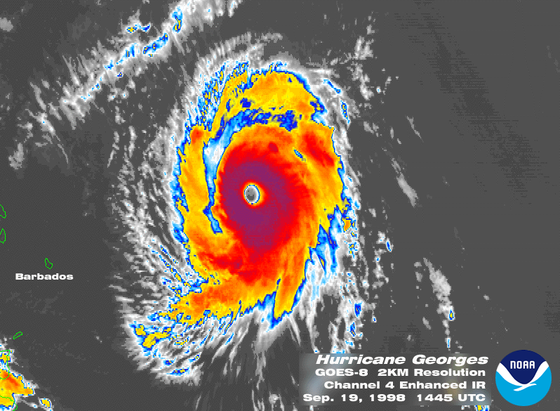
06Z HWRF is basically Georges 2.0, with a strengthening Cat-2/-3 hitting PR, weakening over land, and then re-intensifying into a major before hitting the DR.
Note: people will say it shifted south, but the 06Z/18Z runs lack the full data incorporated into the 12Z/00Z runs. 06Z actually shifted north vs. yesterday’s 18Z.
I’m still thinking a stronger system in the short term, as is currently happening, is likely to pass north of the islands. Models are not finished with their shifts.
0 likes
CVW / MiamiensisWx / Shell Mound
The posts in this forum are NOT official forecasts and should not be used as such. They are just the opinion of the poster and may or may not be backed by sound meteorological data. They are NOT endorsed by any professional institution or STORM2K. For official information, please refer to products from the NHC and NWS.

-
toad strangler

- S2K Supporter

- Posts: 4546
- Joined: Sun Jul 28, 2013 3:09 pm
- Location: Earth
- Contact:
Re: ATL: INVEST 98L - Models
SFLcane wrote:06z Euro...Nada
I wasn't expecting much after 00z.
3 likes
My Weather Station
https://www.wunderground.com/dashboard/pws/KFLPORTS603
https://www.wunderground.com/dashboard/pws/KFLPORTS603
-
SFLcane

- S2K Supporter
- Posts: 10281
- Age: 48
- Joined: Sat Jun 05, 2010 1:44 pm
- Location: Lake Worth Florida
Re: ATL: INVEST 98L - Models
toad strangler wrote:SFLcane wrote:06z Euro...Nada
I wasn't expecting much after 00z.
Watch the convection evolution the euro for now nailing it. Doubt we see any upgrade today at least. Might go poof if trends currently continue
2 likes
-
Evil Jeremy

- S2K Supporter
- Posts: 5463
- Age: 32
- Joined: Mon Apr 10, 2006 2:10 pm
- Location: Los Angeles, CA
Re: ATL: INVEST 98L - Models
Hurricaneman wrote:The models have this moving WNW off the bat when it’s moving due west, I have a feeling that the models will shift south of Hispaniola, hoping so because Puerto Rico and Hispaniola don’t need this
It’s literally pre-Isaias all over again.
3 likes
Frances 04 / Jeanne 04 / Katrina 05 / Wilma 05 / Fay 08 / Debby 12 / Andrea 13 / Colin 16 / Hermine 16 / Matthew 16 / Irma 17
-
eastcoastFL
- Category 5
- Posts: 3996
- Age: 44
- Joined: Thu Apr 12, 2007 12:29 pm
- Location: Palm City, FL
Re: ATL: INVEST 98L - Models
SFLcane wrote:toad strangler wrote:SFLcane wrote:06z Euro...Nada
I wasn't expecting much after 00z.
Watch the convection evolution the euro for now nailing it. Doubt we see any upgrade today at least. Might go poof if trends currently continue
I see what you mean but it’s a little soon to call it a trend. Just 2 hours ago it was firing on all cylinders.
2 likes
Personal Forecast Disclaimer:
The posts in this forum are NOT official forecast and should not be used as such. They are just the opinion of the poster and may or may not be backed by sound meteorological data. They are NOT endorsed by any professional institution or storm2k.org. For official information, please refer to the NHC and NWS products.
The posts in this forum are NOT official forecast and should not be used as such. They are just the opinion of the poster and may or may not be backed by sound meteorological data. They are NOT endorsed by any professional institution or storm2k.org. For official information, please refer to the NHC and NWS products.

Re: ATL: INVEST 98L - Models
Evil Jeremy wrote:Hurricaneman wrote:The models have this moving WNW off the bat when it’s moving due west, I have a feeling that the models will shift south of Hispaniola, hoping so because Puerto Rico and Hispaniola don’t need this
It’s literally pre-Isaias all over again.
It’s getting close to being as frustrating as Isaias as well.
2 likes
Irene '11 Sandy '12 Hermine '16 5/15/2018 Derecho Fay '20 Isaias '20 Elsa '21 Henri '21 Ida '21
I am only a meteorology enthusiast who knows a decent amount about tropical cyclones. Look to the professional mets, the NHC, or your local weather office for the best information.
I am only a meteorology enthusiast who knows a decent amount about tropical cyclones. Look to the professional mets, the NHC, or your local weather office for the best information.

Re: ATL: INVEST 98L - Models
Shell Mound wrote:06Z HWRF is basically Georges 2.0, with a strengthening Cat-2/-3 hitting PR, weakening over land, and then re-intensifying into a major before hitting the DR.
Note: people will say it shifted south, but the 06Z/18Z runs lack the full data incorporated into the 12Z/00Z runs. 06Z actually shifted north vs. yesterday’s 18Z.
I’m still thinking a stronger system in the short term, as is currently happening, is likely to pass north of the islands. Models are not finished with their shifts.
I was thinking this might be similar to Georges. It can be argued that Georges was near cat 5 strength before hitting the islands, it's satellite images were impressive, perfect symmetrical eye, eyewall ECT..
http://huracanado1.tripod.com/sitebuild ... res/06.gif
0 likes
-
SFLcane
- S2K Supporter
- Posts: 10281
- Age: 48
- Joined: Sat Jun 05, 2010 1:44 pm
- Location: Lake Worth Florida
Re: ATL: INVEST 98L - Models
Enjoy Island tour 

Last edited by SFLcane on Wed Aug 19, 2020 8:55 am, edited 1 time in total.
0 likes
-
cp79
Re: ATL: INVEST 98L - Models
SFLcane wrote:12z models Lol see ya... will never amount to much if trends continue. Enjoy Island tour
https://cdn1.bbcode0.com/uploads/2020/8/19/747cc753b6391bf859a26701aa0be64d-full.png
Agree. It appears it’s going to take a visit to the Graveyard of hurricanes. Only concern is if does more of a Charley/Ivan and heads south of Haiti/Cuba. That seems more plausible right now compared to hit heading north of them.
Looking better for the east coast. The GOM still needs to keep an eye on it for the south track.
0 likes
Who is online
Users browsing this forum: No registered users and 47 guests