ATL: ETA - Models
Moderator: S2k Moderators
-
SouthFLTropics

- Category 5

- Posts: 4258
- Age: 50
- Joined: Thu Aug 14, 2003 8:04 am
- Location: Port St. Lucie, Florida
Re: ATL: ETA - Models
The long range models are starting to come into agreement of a large, caged monster pacing back in forth in the Western Caribbean just waiting to strike at the first opportunity a trough gives them. The next 10 to 14 days are likely to be crazy.
7 likes
Fourth Generation Florida Native
Personal Storm History: David 79, Andrew 92, Erin 95, Floyd 99, Irene 99, Frances 04, Jeanne 04, Wilma 05, Matthew 16, Irma 17, Ian 22, Nicole 22, Milton 24
Personal Storm History: David 79, Andrew 92, Erin 95, Floyd 99, Irene 99, Frances 04, Jeanne 04, Wilma 05, Matthew 16, Irma 17, Ian 22, Nicole 22, Milton 24
-
p1nheadlarry

- Category 2

- Posts: 672
- Age: 34
- Joined: Wed Jan 29, 2014 2:42 pm
- Location: SR County FL
Re: ATL: ETA - Models
toad strangler wrote:p1nheadlarry wrote:toad strangler wrote:
A mid November strong 'cane into the FL peninsula. That would be one for the books. The ONLY one for the books.
Not the peninsula but Hurricane Kate hit Mexico Beach as a solid Cat-2 right around Thanksgiving in '85. Worst storm in the Big Bend region until Oct 10 2018.
Indeed but Kate was not a Caribbean storm. She is one of your TWO examples since 1859 … the other was not of Caribbean origin either. So this would be a first time for the books should it happen. Still a long shot though.
Ok, but Michael was of Caribbean origin (CAG); however not your traditional WCARIB storm a la Wilma or Gilbert.
0 likes
--;->#GoNoles--;->.
-
toad strangler

- S2K Supporter

- Posts: 4546
- Joined: Sun Jul 28, 2013 3:09 pm
- Location: Earth
- Contact:
Re: ATL: ETA - Models
p1nheadlarry wrote:toad strangler wrote:p1nheadlarry wrote:
Not the peninsula but Hurricane Kate hit Mexico Beach as a solid Cat-2 right around Thanksgiving in '85. Worst storm in the Big Bend region until Oct 10 2018.
Indeed but Kate was not a Caribbean storm. She is one of your TWO examples since 1859 … the other was not of Caribbean origin either. So this would be a first time for the books should it happen. Still a long shot though.
Ok, but Michael was of Caribbean origin (CAG); however not your traditional WCARIB storm a la Wilma or Gilbert.
Michael was in October. Not November.
2 likes
My Weather Station
https://www.wunderground.com/dashboard/pws/KFLPORTS603
https://www.wunderground.com/dashboard/pws/KFLPORTS603
-
Deshaunrob17
- Tropical Storm

- Posts: 211
- Joined: Tue Aug 18, 2020 7:49 am
Re: ATL: ETA - Models
Another win for the GFS in 2020... Looks like Euro is trending to the Caribbean side... More importantly, another win for GFS para for picking up this system.... GFS Para has been leading the way the tropical cyclone genesis in the Atlantic even though it can be a tad bullish
6 likes
-
p1nheadlarry
- Category 2
- Posts: 672
- Age: 34
- Joined: Wed Jan 29, 2014 2:42 pm
- Location: SR County FL
Re: ATL: ETA - Models
toad strangler wrote:p1nheadlarry wrote:toad strangler wrote:
Indeed but Kate was not a Caribbean storm. She is one of your TWO examples since 1859 … the other was not of Caribbean origin either. So this would be a first time for the books should it happen. Still a long shot though.
Ok, but Michael was of Caribbean origin (CAG); however not your traditional WCARIB storm a la Wilma or Gilbert.
Michael was in October. Not November.
I read "one of your two examples" as literally one of my two examples
1 likes
--;->#GoNoles--;->.
-
TheStormExpert
Re: ATL: ETA - Models
p1nheadlarry wrote:Only parallel I can think of is Michelle in 2001
Makes sense. Just don’t see how a storm can strike Florida from the SW in November. I expect the models to shift south and east with the latest 12z guidance trending that way.
2 likes
-
SconnieCane
- Category 5
- Posts: 1013
- Joined: Thu Aug 02, 2018 5:29 pm
- Location: Madison, WI
Re: ATL: ETA - Models
TheStormExpert wrote:p1nheadlarry wrote:Only parallel I can think of is Michelle in 2001
Makes sense. Just don’t see how a storm can strike Florida from the SW in November. I expect the models to shift south and east with the latest 12z guidance trending that way.
Same way Wilma did in late October...
6 likes

Re: ATL: ETA - Models
TheStormExpert wrote:p1nheadlarry wrote:Only parallel I can think of is Michelle in 2001
Makes sense. Just don’t see how a storm can strike Florida from the SW in November. I expect the models to shift south and east with the latest 12z guidance trending that way.
I agree with you because earlier I pointed out the same thing and another poster pointed out that high pressure is supposed to build back in and turn it NW towards us.
0 likes
-
tolakram
- Admin

- Posts: 20179
- Age: 62
- Joined: Sun Aug 27, 2006 8:23 pm
- Location: Florence, KY (name is Mark)
Re: ATL: ETA - Models
The term Florida shield does not belong in this discussion or frankly any discussion, I'm tired of reading about it and the dumb responses. I moved a bunch of posts to the moderation area.
STAY ON TOPIC. If you want to discuss model runs and scientific analysis (as best we amateurs can) that's fine, but stop the nonsense please.
STAY ON TOPIC. If you want to discuss model runs and scientific analysis (as best we amateurs can) that's fine, but stop the nonsense please.
11 likes
M a r k
- - - - -
Join us in chat: Storm2K Chatroom Invite. Android and IOS apps also available.
The posts in this forum are NOT official forecasts and should not be used as such. Posts are NOT endorsed by any professional institution or STORM2K.org. For official information and forecasts, please refer to NHC and NWS products.
-
wxman57

- Moderator-Pro Met

- Posts: 23172
- Age: 68
- Joined: Sat Jun 21, 2003 8:06 pm
- Location: Houston, TX (southwest)
Re: ATL: ETA - Models
NHC track is right along consensus (TVCN). I figured they couldn't keep it inland forever in the 5-day forecast. Times on the graphic are in CST. Last point of the NHC track is 6am Saturday. Last point in TVCN is 6am Monday.

1 likes
-
gatorcane

- S2K Supporter
- Posts: 23708
- Age: 48
- Joined: Sun Mar 13, 2005 3:54 pm
- Location: Boca Raton, FL
Re: ATL: ETA - Models
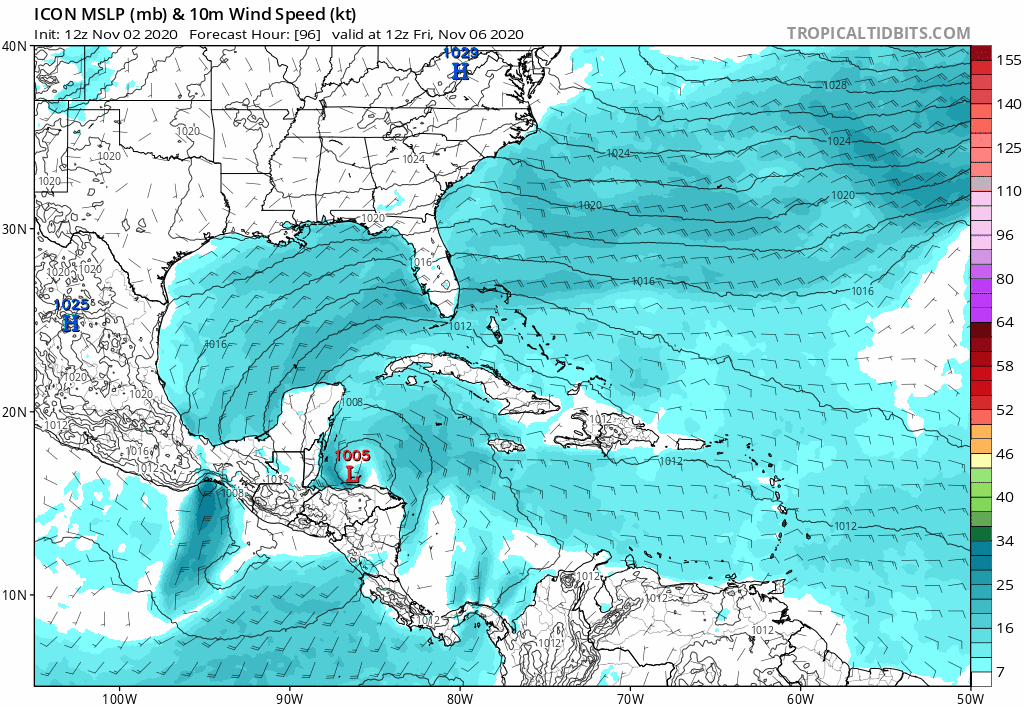
This is definitely a time to not put much stock in the models beyond 5 days especially until we see what re-emerges into the Gulf of Honduras. But taking a peek at the start of 12Z global guidance already shows a big shift east with the ICON:
1 likes
-
toad strangler
- S2K Supporter
- Posts: 4546
- Joined: Sun Jul 28, 2013 3:09 pm
- Location: Earth
- Contact:
Re: ATL: ETA - Models
gatorcane wrote:This is definitely a time to not put much stock in the models beyond 5 days especially until we see what re-emerges into the Gulf of Honduras. But taking a peek at the start of 12Z global guidance already shows a big shift east with the ICON:
https://i.postimg.cc/cJwYWPBY/icon-mslp-wind-watl-fh96-174.gif
This type of scenario would be most expected per climo and what I think will happen should Eta survive the CA plunge.
0 likes
My Weather Station
https://www.wunderground.com/dashboard/pws/KFLPORTS603
https://www.wunderground.com/dashboard/pws/KFLPORTS603
-
Blown Away

- S2K Supporter
- Posts: 10253
- Joined: Wed May 26, 2004 6:17 am
Re: ATL: ETA - Models
gatorcane wrote:This is definitely a time to not put much stock in the models beyond 5 days especially until we see what re-emerges into the Gulf of Honduras. But taking a peek at the start of 12Z global guidance already shows a big shift east with the ICON:
https://i.postimg.cc/cJwYWPBY/icon-mslp-wind-watl-fh96-174.gif
I think if extrapolate that past 180 hours, Eta would be forced back W. Crazy track.
2 likes
Hurricane Eye Experience: David 79, Irene 99, Frances 04, Jeanne 04, Wilma 05… Hurricane Brush Experience: Andrew 92, Erin 95, Floyd 99, Matthew 16, Irma 17, Ian 22, Nicole 22…
-
Hurricane Mike
- Category 2
- Posts: 675
- Joined: Tue Apr 10, 2018 7:44 am
Re: ATL: ETA - Models
If that EURO model panned out, the rainfall would be historically devastating for Central America.
0 likes
-
AutoPenalti
- Category 5
- Posts: 4091
- Age: 29
- Joined: Mon Aug 17, 2015 4:16 pm
- Location: Ft. Lauderdale, Florida
Re: ATL: ETA - Models
gatorcane wrote:This is definitely a time to not put much stock in the models beyond 5 days especially until we see what re-emerges into the Gulf of Honduras. But taking a peek at the start of 12Z global guidance already shows a big shift east with the ICON:
https://i.postimg.cc/cJwYWPBY/icon-mslp-wind-watl-fh96-174.gif
So whatever happened to that massive ridge people were talking about?
0 likes
The posts in this forum are NOT official forecasts and should not be used as such. They are just the opinion of the poster and may or may not be backed by sound meteorological data. They are NOT endorsed by any professional institution or STORM2K. For official information, please refer to products from the NHC and NWS.
Model Runs Cheat Sheet:
GFS (5:30 AM/PM, 11:30 AM/PM)
HWRF, GFDL, UKMET, NAVGEM (6:30-8:00 AM/PM, 12:30-2:00 AM/PM)
ECMWF (1:45 AM/PM)
TCVN is a weighted averaged
-
chris_fit

- Category 5
- Posts: 3261
- Age: 43
- Joined: Wed Sep 10, 2003 11:58 pm
- Location: Tampa Bay Area, FL
Re: ATL: ETA - Models
gatorcane wrote:This is definitely a time to not put much stock in the models beyond 5 days especially until we see what re-emerges into the Gulf of Honduras. But taking a peek at the start of 12Z global guidance already shows a big shift east with the ICON:
https://i.postimg.cc/cJwYWPBY/icon-mslp-wind-watl-fh96-174.gif
Same with the GFS through 130 hours - Way E
0 likes
-
Blown Away
- S2K Supporter
- Posts: 10253
- Joined: Wed May 26, 2004 6:17 am
Re: ATL: ETA - Models
chris_fit wrote:gatorcane wrote:This is definitely a time to not put much stock in the models beyond 5 days especially until we see what re-emerges into the Gulf of Honduras. But taking a peek at the start of 12Z global guidance already shows a big shift east with the ICON:
https://i.postimg.cc/cJwYWPBY/icon-mslp-wind-watl-fh96-174.gif
Same with the GFS through 130 hours - Way E
My guess is a loop beginning @130 hours.
0 likes
Hurricane Eye Experience: David 79, Irene 99, Frances 04, Jeanne 04, Wilma 05… Hurricane Brush Experience: Andrew 92, Erin 95, Floyd 99, Matthew 16, Irma 17, Ian 22, Nicole 22…
-
AutoPenalti
- Category 5
- Posts: 4091
- Age: 29
- Joined: Mon Aug 17, 2015 4:16 pm
- Location: Ft. Lauderdale, Florida
Re: ATL: ETA - Models
Blown Away wrote:chris_fit wrote:gatorcane wrote:This is definitely a time to not put much stock in the models beyond 5 days especially until we see what re-emerges into the Gulf of Honduras. But taking a peek at the start of 12Z global guidance already shows a big shift east with the ICON:
https://i.postimg.cc/cJwYWPBY/icon-mslp-wind-watl-fh96-174.gif
Same with the GFS through 130 hours - Way E
My guess is a loop beginning @130 hours.
Nope.
0 likes
The posts in this forum are NOT official forecasts and should not be used as such. They are just the opinion of the poster and may or may not be backed by sound meteorological data. They are NOT endorsed by any professional institution or STORM2K. For official information, please refer to products from the NHC and NWS.
Model Runs Cheat Sheet:
GFS (5:30 AM/PM, 11:30 AM/PM)
HWRF, GFDL, UKMET, NAVGEM (6:30-8:00 AM/PM, 12:30-2:00 AM/PM)
ECMWF (1:45 AM/PM)
TCVN is a weighted averaged
-
supercane4867
- Category 5
- Posts: 4966
- Joined: Wed Nov 14, 2012 10:43 am

-
chris_fit
- Category 5
- Posts: 3261
- Age: 43
- Joined: Wed Sep 10, 2003 11:58 pm
- Location: Tampa Bay Area, FL
Re: ATL: ETA - Models
Looks like it's going to go the other way now (West or NW) @ 160 hours.
0 likes
Who is online
Users browsing this forum: No registered users and 89 guests