Haven’t been on the last couple of hours, but I noticed that TD 13 finally initialized.
Of course now some models are actually weakening this right after this was classified. No surprises there.
ATL: LAURA - Post-Tropical - Discussion
Moderator: S2k Moderators
-
AutoPenalti
- Category 5

- Posts: 4091
- Age: 29
- Joined: Mon Aug 17, 2015 4:16 pm
- Location: Ft. Lauderdale, Florida
Re: ATL: THIRTEEN - Tropical Depression - Discussion
0 likes
The posts in this forum are NOT official forecasts and should not be used as such. They are just the opinion of the poster and may or may not be backed by sound meteorological data. They are NOT endorsed by any professional institution or STORM2K. For official information, please refer to products from the NHC and NWS.
Model Runs Cheat Sheet:
GFS (5:30 AM/PM, 11:30 AM/PM)
HWRF, GFDL, UKMET, NAVGEM (6:30-8:00 AM/PM, 12:30-2:00 AM/PM)
ECMWF (1:45 AM/PM)
TCVN is a weighted averaged
-
SouthFLTropics

- Category 5
- Posts: 4258
- Age: 50
- Joined: Thu Aug 14, 2003 8:04 am
- Location: Port St. Lucie, Florida
Re: ATL: THIRTEEN - Tropical Depression - Discussion
eastcoastFL wrote:SouthFLTropics wrote:eastcoastFL wrote:
Feeling safeish for now up here in southern Martin county.
Ooof, that's it...Now you went and done it. Now you've cursed us on the Treasure Coast.
In all seriousness, I'll feel safe once this thing is north of us. Until then, all bets are off.
North of us? I like it better being south of us. I don’t want to see any shifts north. I feel like this one should stay to our south. I think it may end up missing Miami through the keys even...
North means it's headed out and won't likely come back (Except for Jeanne and Betsy). If it's South of us, we are still in play.
5 likes
Fourth Generation Florida Native
Personal Storm History: David 79, Andrew 92, Erin 95, Floyd 99, Irene 99, Frances 04, Jeanne 04, Wilma 05, Matthew 16, Irma 17, Ian 22, Nicole 22, Milton 24
Personal Storm History: David 79, Andrew 92, Erin 95, Floyd 99, Irene 99, Frances 04, Jeanne 04, Wilma 05, Matthew 16, Irma 17, Ian 22, Nicole 22, Milton 24
-
DestinHurricane

- Category 4

- Posts: 935
- Joined: Tue May 01, 2018 8:05 am
- Location: New York, NY
Re: ATL: THIRTEEN - Tropical Depression - Discussion
eastcoastFL wrote:SouthFLTropics wrote:eastcoastFL wrote:
Feeling safeish for now up here in southern Martin county.
Ooof, that's it...Now you went and done it. Now you've cursed us on the Treasure Coast.
In all seriousness, I'll feel safe once this thing is north of us. Until then, all bets are off.
North of us? I like it better being south of us. I don’t want to see any shifts north. I feel like this one should stay to our south. I think it may end up missing Miami through the keys even...
Why do you like it better south of you? That would mean an onshore flow, worse winds, and higher probability of it shifting towards you as shifts northeast towards a recurve are usually more common than the other way in this situation.
6 likes
Michael 2018
Re: ATL: THIRTEEN - Tropical Depression - Discussion
AutoPenalti wrote:Haven’t been on the last couple of hours, but I noticed that TD 13 finally initialized.
Of course now some models are actually weakening this right after this was classified. No surprises there.
The 6z models will be the first ones after classification, so we would wait to see what they do with it.
0 likes
-
ozonepete
- Professional-Met

- Posts: 4743
- Joined: Mon Sep 07, 2009 3:23 pm
- Location: From Ozone Park, NYC / Now in Brooklyn, NY
Re: ATL: THIRTEEN - Tropical Depression - Discussion
wx98 wrote:AutoPenalti wrote:Haven’t been on the last couple of hours, but I noticed that TD 13 finally initialized.
Of course now some models are actually weakening this right after this was classified. No surprises there.
The 6z models will be the first ones after classification, so we would wait to see what they do with it.
The 12Z global will be most important/interesting.
2 likes
-
AutoPenalti
- Category 5
- Posts: 4091
- Age: 29
- Joined: Mon Aug 17, 2015 4:16 pm
- Location: Ft. Lauderdale, Florida
Re: ATL: THIRTEEN - Tropical Depression - Discussion
ozonepete wrote:wx98 wrote:AutoPenalti wrote:Haven’t been on the last couple of hours, but I noticed that TD 13 finally initialized.
Of course now some models are actually weakening this right after this was classified. No surprises there.
The 6z models will be the first ones after classification, so we would wait to see what they do with it.
The 12Z global will be most important/interesting.
That’s assuming it’s established a center by then.
0 likes
The posts in this forum are NOT official forecasts and should not be used as such. They are just the opinion of the poster and may or may not be backed by sound meteorological data. They are NOT endorsed by any professional institution or STORM2K. For official information, please refer to products from the NHC and NWS.
Model Runs Cheat Sheet:
GFS (5:30 AM/PM, 11:30 AM/PM)
HWRF, GFDL, UKMET, NAVGEM (6:30-8:00 AM/PM, 12:30-2:00 AM/PM)
ECMWF (1:45 AM/PM)
TCVN is a weighted averaged
-
jaxfladude
- Category 5
- Posts: 1249
- Joined: Wed Aug 24, 2005 9:36 pm
- Location: Jacksonville, Fla
Re: ATL: THIRTEEN - Tropical Depression - Discussion
Local Northeast Florida area impacts will be what strong winds lots of rains, or too soon to tell?
0 likes
Stay safe y'all
-
curtadams
- S2K Supporter

- Posts: 1122
- Joined: Sun Aug 28, 2005 7:57 pm
- Location: Orange, California
- Contact:
Re: ATL: THIRTEEN - Tropical Depression - Discussion
It's a ginormous system, and big systems have a hard time staying formally closed. When the globals "lose" it maybe they're just thinking it'll stay a great big unclosed sort-of-low, which isn't crazy. Northerly convection notwithstanding, if you look at the clouds for an area not moving or going west, you have to look near the ITCZ, implying the surface low, if there is one, is pretty low latitude and far from that convection, which is not favorable for development.
0 likes
-
ozonepete
- Professional-Met
- Posts: 4743
- Joined: Mon Sep 07, 2009 3:23 pm
- Location: From Ozone Park, NYC / Now in Brooklyn, NY
Re: ATL: THIRTEEN - Tropical Depression - Discussion
jaxfladude wrote:Local Northeast Florida area impacts will be what strong winds lots of rains, or too soon to tell?
Way too soon.
1 likes
-
Shell Mound
- Category 5
- Posts: 2432
- Age: 33
- Joined: Thu Sep 07, 2017 3:39 pm
- Location: St. Petersburg, FL → Scandinavia
Re: ATL: THIRTEEN - Tropical Depression - Discussion
https://twitter.com/webberweather/status/1296235432066396161
https://twitter.com/webberweather/status/1296238371325521928
https://twitter.com/webberweather/status/1296240023940009984
https://twitter.com/AndyHazelton/status/1296243480575070209
https://twitter.com/JackSillin/status/1296238992225120256
https://twitter.com/webberweather/status/1296238371325521928
https://twitter.com/webberweather/status/1296240023940009984
https://twitter.com/AndyHazelton/status/1296243480575070209
https://twitter.com/JackSillin/status/1296238992225120256
0 likes
CVW / MiamiensisWx / Shell Mound
The posts in this forum are NOT official forecasts and should not be used as such. They are just the opinion of the poster and may or may not be backed by sound meteorological data. They are NOT endorsed by any professional institution or STORM2K. For official information, please refer to products from the NHC and NWS.
-
ColdMiser123

- Professional-Met
- Posts: 905
- Age: 29
- Joined: Mon Sep 26, 2016 3:26 pm
- Location: Northeast US
Re: ATL: THIRTEEN - Tropical Depression - Discussion
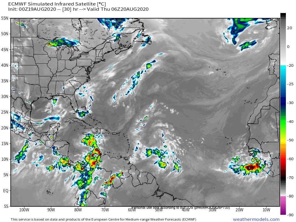
This was the 0z Euro forecast valid at hour 30, less than 2 hours from now. It didn't have any convection colder than ~-50 C, which clearly isn't the case so far, since we have plenty of <-70 C cloud tops.
Last edited by ColdMiser123 on Wed Aug 19, 2020 11:33 pm, edited 1 time in total.
12 likes
B.S., M.S., Meteorology & Atmospheric Science

Re: ATL: THIRTEEN - Tropical Depression - Discussion
ColdMiser123 wrote:This was the 0z Euro forecast valid at hour 30, less than 2 hours from now. It didn't have any convection colder than -50 C, which clearly isn't the case so far, since we have plenty of <-70 C cloud tops.
https://pbs.twimg.com/media/EfyWC9qWsAAo_9U?format=jpg&name=medium
Seems like the Euro simply isn't reading the atmosphere correctly. GFS/Icon have pretty similar scenarios, along with the CMC albeit with it's typical east bias--and all three vastly different than the Euro.
2 likes
The above post is not official and should not be used as such. It is the opinion of the poster and may or may not be backed by sound meteorological data. It is not endorsed by any professional institution or storm2k.org. For official information, please refer to the NHC and NWS products.
-
ozonepete
- Professional-Met
- Posts: 4743
- Joined: Mon Sep 07, 2009 3:23 pm
- Location: From Ozone Park, NYC / Now in Brooklyn, NY
Re: ATL: THIRTEEN - Tropical Depression - Discussion
ColdMiser123 wrote:This was the 0z Euro forecast valid at hour 30, less than 2 hours from now. It didn't have any convection colder than ~-50 C, which clearly isn't the case so far, since we have plenty of <-70 C cloud tops.
https://pbs.twimg.com/media/EfyWC9qWsAAo_9U?format=jpg&name=medium
Shows how much further both we and the models have to go.
5 likes
-
SouthFLTropics
- Category 5
- Posts: 4258
- Age: 50
- Joined: Thu Aug 14, 2003 8:04 am
- Location: Port St. Lucie, Florida
Re: ATL: THIRTEEN - Tropical Depression - Discussion
Whoever made that Miami to Cedar Key forecast a little bit ago. CMC is not far off from it. Maybe a hair north on the landfall.
1 likes
Fourth Generation Florida Native
Personal Storm History: David 79, Andrew 92, Erin 95, Floyd 99, Irene 99, Frances 04, Jeanne 04, Wilma 05, Matthew 16, Irma 17, Ian 22, Nicole 22, Milton 24
Personal Storm History: David 79, Andrew 92, Erin 95, Floyd 99, Irene 99, Frances 04, Jeanne 04, Wilma 05, Matthew 16, Irma 17, Ian 22, Nicole 22, Milton 24
-
ColdMiser123
- Professional-Met
- Posts: 905
- Age: 29
- Joined: Mon Sep 26, 2016 3:26 pm
- Location: Northeast US
Re: ATL: THIRTEEN - Tropical Depression - Discussion
ozonepete wrote:ColdMiser123 wrote:This was the 0z Euro forecast valid at hour 30, less than 2 hours from now. It didn't have any convection colder than ~-50 C, which clearly isn't the case so far, since we have plenty of <-70 C cloud tops.
https://pbs.twimg.com/media/EfyWC9qWsAAo_9U?format=jpg&name=medium
Shows how much further both we and the models have to go.
This could be an excellent satellite DA case study for a graduate research project.
4 likes
B.S., M.S., Meteorology & Atmospheric Science
-
ozonepete
- Professional-Met
- Posts: 4743
- Joined: Mon Sep 07, 2009 3:23 pm
- Location: From Ozone Park, NYC / Now in Brooklyn, NY
Re: ATL: THIRTEEN - Tropical Depression - Discussion
Hurricaneman wrote:Here’s my forecast and those between Palm Beach to the Key West May need to prepare for a major hurricane
Here is the forecast intensity
Now. TD. 35mph
12hrs. TS. 40mph
24hrs. TS. 45mph
36hrs. TS. 50mph
48hrs. TS 60mph
72hrs. C1. 80mph
96hrs. C2. 100mph
108hrs C2. 110mph over Miami
120hrs C1 85mph Over Lakeland
144hrs. C1. 80mph near Cedar Key
You really have to put a plainly visible disclaimer on a forecast like that (or any really) that it's a non-professional opinion.
There are a lot of people on here who might panic after seeing your forecast and spread it to other people.
11 likes
-
Evil Jeremy

- S2K Supporter
- Posts: 5463
- Age: 32
- Joined: Mon Apr 10, 2006 2:10 pm
- Location: Los Angeles, CA
Re: ATL: THIRTEEN - Tropical Depression - Discussion
ozonepete wrote:You really have to put a plainly visible disclaimer on a forecast like that (or any really) that it's a non-professional opinion.
There are a lot of people on here who might panic after seeing your forecast and spread it to other people.
Unrelated, but remember 10+ years ago when people had their own forecast threads with regular “advisories”? And the pro-Mets has their own forum for their personal advisories? Good times...
8 likes
Frances 04 / Jeanne 04 / Katrina 05 / Wilma 05 / Fay 08 / Debby 12 / Andrea 13 / Colin 16 / Hermine 16 / Matthew 16 / Irma 17
-
Hurricane Mike
- Category 2

- Posts: 675
- Joined: Tue Apr 10, 2018 7:44 am
Re: ATL: THIRTEEN - Tropical Depression - Discussion
Have there been any synoptic flights ahead of this thing yet?
0 likes
-
Hurricaneman

- Category 5
- Posts: 7404
- Age: 45
- Joined: Tue Aug 31, 2004 3:24 pm
- Location: central florida
Re: ATL: THIRTEEN - Tropical Depression - Discussion
Hurricane Mike wrote:Have there been any synoptic flights ahead of this thing yet?
Not yet but I do expect them either tomorrow or Friday
0 likes
-
Shell Mound
- Category 5
- Posts: 2432
- Age: 33
- Joined: Thu Sep 07, 2017 3:39 pm
- Location: St. Petersburg, FL → Scandinavia
Re: ATL: THIRTEEN - Tropical Depression - Discussion
Personally, I think there is a good chance that this ends up missing FL to the east, given that models are underestimating short-term as well as long-term organisation. The key is that the ridge to its north is going to be narrow. Any changes in either the size/intensity of 98L and/or the orientation of the ridge axis relative to the numerous shortwave impulses will make a tremendous difference, since 98L will be nearing the Bahamas and FL at an angle, heading WNW or even NW. This puts us in yet another Matthew-, Irma-, or Dorian-type scenario, with potentially large ramifications. Note that the global models show persistent northwesterly flow over the Northeastern U.S. This kind of pattern normally would favour a sharp curve at some point, especially if one is contending with a powerful major hurricane. Of course, uncertainty is still high at this stage, but climatology and the upcoming setup combined would normally favour a track missing FL, especially if we are dealing with a major hurricane.
CMC
ECMWF
EPS
CMC
ECMWF
EPS
3 likes
CVW / MiamiensisWx / Shell Mound
The posts in this forum are NOT official forecasts and should not be used as such. They are just the opinion of the poster and may or may not be backed by sound meteorological data. They are NOT endorsed by any professional institution or STORM2K. For official information, please refer to products from the NHC and NWS.
Who is online
Users browsing this forum: No registered users and 40 guests