ATL: LAURA - Post-Tropical - Discussion

Moderator: S2k Moderators

Message
Author
AutoPenalti
Category 5
Category 5
Posts: 4030
Age: 29
Joined: Mon Aug 17, 2015 4:16 pm
Location: Ft. Lauderdale, Florida

Re: ATL: THIRTEEN - Tropical Depression - Discussion

#941 Postby AutoPenalti » Thu Aug 20, 2020 8:10 am

SFLcane wrote:
Blown Away wrote:
SconnieCane wrote:
An hour and a half ago it looked "horrible" according to SFLcane.


At the surface much better, true LLC likely there. SFLCane I think meant appearance on the IR, doesn't tell the whole story.


Still think satellite appearance is meh this morning.

For a TD, this looks sufficient.
6 likes   
The posts in this forum are NOT official forecasts and should not be used as such. They are just the opinion of the poster and may or may not be backed by sound meteorological data. They are NOT endorsed by any professional institution or STORM2K. For official information, please refer to products from the NHC and NWS.


Model Runs Cheat Sheet:
GFS (5:30 AM/PM, 11:30 AM/PM)
HWRF, GFDL, UKMET, NAVGEM (6:30-8:00 AM/PM, 12:30-2:00 AM/PM)
ECMWF (1:45 AM/PM)

TCVN
is a weighted averaged

User avatar
SFLcane
S2K Supporter
S2K Supporter
Posts: 10163
Age: 47
Joined: Sat Jun 05, 2010 1:44 pm
Location: Lake Worth Florida

Re: ATL: THIRTEEN - Tropical Depression - Discussion

#942 Postby SFLcane » Thu Aug 20, 2020 8:14 am

AutoPenalti wrote:
SFLcane wrote:
Blown Away wrote:
At the surface much better, true LLC likely there. SFLCane I think meant appearance on the IR, doesn't tell the whole story.


Still think satellite appearance is meh this morning.

For a TD, this looks sufficient.


Sure.. just would like to see a little more consolidation.
0 likes   

Do_For_Love
Category 1
Category 1
Posts: 271
Age: 35
Joined: Sat May 09, 2015 7:47 am
Location: Delaware

Re: ATL: THIRTEEN - Tropical Depression - Discussion

#943 Postby Do_For_Love » Thu Aug 20, 2020 8:18 am

Levi Cowan pointed out some factors that could keep a lid on TD13 for today, such as shearing and some SAL influence. After that though it probably will strengthen, which the NHC also agrees with in it's current forecast. My takeaway from all that is that there is a lot of uncertainty with the system but it definitely has potential to develop further and to be dangerous.

 https://twitter.com/TropicalTidbits/status/1296430785256476672


The posts in this forum are NOT official forecasts and should not be used as such. They are just the opinion of the poster and may or may not be backed by sound meteorological data. They are NOT endorsed by any professional institution or STORM2K. For official information, please refer to products from the NHC and NWS.
2 likes   
Irene '11, Sandy '12, Fay '20, Isaias '20, Ida '21

User avatar
Evil Jeremy
S2K Supporter
S2K Supporter
Posts: 5463
Age: 32
Joined: Mon Apr 10, 2006 2:10 pm
Location: Los Angeles, CA

Re: ATL: THIRTEEN - Tropical Depression - Discussion

#944 Postby Evil Jeremy » Thu Aug 20, 2020 8:26 am

Based on this morning’s models, the NHC is all but certain to bump the cone up slightly at 11am. I would also expect them to forecast a Hurricane in days 4-5. I understood why they didn’t go that route last night, but the message needs to be conveyed now that this will have a ripe environment for strengthening in the Bahamas.
5 likes   
Frances 04 / Jeanne 04 / Katrina 05 / Wilma 05 / Fay 08 / Debby 12 / Andrea 13 / Colin 16 / Hermine 16 / Matthew 16 / Irma 17

Shell Mound
Category 5
Category 5
Posts: 2434
Age: 32
Joined: Thu Sep 07, 2017 3:39 pm
Location: St. Petersburg, FL → Scandinavia

Re: ATL: THIRTEEN - Tropical Depression - Discussion

#945 Postby Shell Mound » Thu Aug 20, 2020 8:39 am

BensonTCwatcher wrote:Hmm seeing a LOT of confident statements in the blocking ridge setup, and I am not stating that that in any way that scenario is not the most likely one at this time. But own personal observations of many other synoptic scale setups 100 hours or more in the future has something nagging at me.

1. The "thumb" portion of the ridge that will be in place SW of Bermuda with the East/West axis is clearly the dominant steering feature ( sown on GFS 500 mb height)
2. I see in the GFS model upstream sampling (soundings) ahead of the storm the steering flow at 102 hours is WNW up through 500 mb height
3. I also notice the flow is much more northerly both above 500 mb AND as you go up the FL east coast. There does not seem to be any wiggle room either. I see that if this storm is stronger than forecast at 102 hours, or if it is riding the right side of the forecast envelope it could be influenced by the change in the steering vector right at the "thumbnail" portion of the clockwise flow - somewhere around WPB.
4. The above factors combined with the angle of the FL coast makes a FL landfall point forecast slip up the coast as it approaches. Given we are still pretty far out from this point, I can see at least a possibility that this "misses the 2 a.m. Monday forecast point by being much stronger than a TS and being a tad on the right of the guidance. There are ensemble members showing this on the latest run. Not at all saying this re-curves OTS or anything like that, or even that this does not get into the Gulf - still most likely- just that clearly the intensity forecast confidence is low and if this at all a strong hurricane coming through the Bahamas it looks like the steering flow will be quite different. Some Dominoes stacked up here on this one. Won't be sure which way they will fall till the wee hours on Monday though.

Regarding the upcoming 500-mb synoptic setup: there is a striking similarity between the ensemble projections and the analysed setup for Matthew (2016) in terms of the orientation, position, and amplitude of the Western Atlantic Ridge (WAR). (Additionally, note that several models have shifted eastward since 06Z, a few of which even show some eastward component by the end of the period.) Note that the 590-dm contour forms a parabolic, SSE-to-NNE curve near the longitude of West Palm Beach or slightly eastward. If TD Thirteen is a strong (that is, deep) Category-4+ TC as it nears and passes through the Bahamas, then it is likely to sense the western edge of this contour, since such a strong system would easily reach the highest of the mid-levels. So at this point I will continue to give 60/40 advantage to the likelihood that TD Thirteen, while attaining major-hurricane status, will curve between FL and Grand Bahama, narrowly missing FL to the east, à la Matthew (2016). Unfortunately, the Bahamas will very likely experience a devastating hurricane, particularly the central and northwestern Bahamas, including New Providence, the site of the capital Nassau, and Grand Bahama. Those areas would likely experience the northeastern portion of the RMW. If the ridge were stronger and farther NW I would put the risk to South Florida at a much higher level of likelihood.
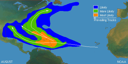
06Z GEFS
00Z EPS
Matthew (2016)

Mean climatological path (August)
Last edited by Shell Mound on Thu Aug 20, 2020 8:45 am, edited 1 time in total.
0 likes   
CVW / MiamiensisWx / Shell Mound
The posts in this forum are NOT official forecasts and should not be used as such. They are just the opinion of the poster and may or may not be backed by sound meteorological data. They are NOT endorsed by any professional institution or STORM2K. For official information, please refer to products from the NHC and NWS.

User avatar
SFLcane
S2K Supporter
S2K Supporter
Posts: 10163
Age: 47
Joined: Sat Jun 05, 2010 1:44 pm
Location: Lake Worth Florida

Re: ATL: THIRTEEN - Tropical Depression - Discussion

#946 Postby SFLcane » Thu Aug 20, 2020 8:40 am

I am not fully convinced this is a TD right now.

Image
2 likes   

User avatar
wxman57
Moderator-Pro Met
Moderator-Pro Met
Posts: 22980
Age: 67
Joined: Sat Jun 21, 2003 8:06 pm
Location: Houston, TX (southwest)

Re: ATL: THIRTEEN - Tropical Depression - Discussion

#947 Postby wxman57 » Thu Aug 20, 2020 8:45 am

Thirteen needs to wear a dust mask. Dust is being drawn into the SW quadrant now. More dust ahead across Bahamas south through Caribbean.

Image
6 likes   

User avatar
gfsperpendicular
Category 1
Category 1
Posts: 383
Age: 21
Joined: Mon Jun 19, 2017 3:04 pm
Location: Northern Virginia

Re: ATL: THIRTEEN - Tropical Depression - Discussion

#948 Postby gfsperpendicular » Thu Aug 20, 2020 8:47 am

Looks like it's outrun the anticyclone a little bit, could lead to it being hit hard by shear if it continues
Image
0 likes   
I'm not sleeping, I'm waiting for the 0900 UTC advisory!

#1 CMC stan

User avatar
SFLcane
S2K Supporter
S2K Supporter
Posts: 10163
Age: 47
Joined: Sat Jun 05, 2010 1:44 pm
Location: Lake Worth Florida

Re: ATL: THIRTEEN - Tropical Depression - Discussion

#949 Postby SFLcane » Thu Aug 20, 2020 8:49 am

Not well organized at all. Plenty of obstacles ahead.

Euro has nothing so there is still some chance it may end up being correct and this never develops.
2 likes   

User avatar
toad strangler
S2K Supporter
S2K Supporter
Posts: 4543
Joined: Sun Jul 28, 2013 3:09 pm
Location: Earth
Contact:

Re: ATL: THIRTEEN - Tropical Depression - Discussion

#950 Postby toad strangler » Thu Aug 20, 2020 8:49 am

SFLcane wrote:
Blown Away wrote:
SconnieCane wrote:
An hour and a half ago it looked "horrible" according to SFLcane.


At the surface much better, true LLC likely there. SFLCane I think meant appearance on the IR, doesn't tell the whole story.


Still think satellite appearance is meh this morning.


Well, according to Levi Cowan it's going to be a mess until and IF it clear the big islands to the N. IF that happens, he said would be the time for real organization and much better environment.. That's not for a long while yet.
0 likes   

AutoPenalti
Category 5
Category 5
Posts: 4030
Age: 29
Joined: Mon Aug 17, 2015 4:16 pm
Location: Ft. Lauderdale, Florida

Re: ATL: THIRTEEN - Tropical Depression - Discussion

#951 Postby AutoPenalti » Thu Aug 20, 2020 8:51 am

SFLcane wrote:Not well organized at all. Plenty of obstacles ahead.

Euro has nothing so there is still some chance it may end up being correct and this never develops.

Yikes, that would be a full blown flop from all models if that were the case, Levi did mention that this has potential to be a lot stronger once shear relaxes.
0 likes   
The posts in this forum are NOT official forecasts and should not be used as such. They are just the opinion of the poster and may or may not be backed by sound meteorological data. They are NOT endorsed by any professional institution or STORM2K. For official information, please refer to products from the NHC and NWS.


Model Runs Cheat Sheet:
GFS (5:30 AM/PM, 11:30 AM/PM)
HWRF, GFDL, UKMET, NAVGEM (6:30-8:00 AM/PM, 12:30-2:00 AM/PM)
ECMWF (1:45 AM/PM)

TCVN
is a weighted averaged

User avatar
Evil Jeremy
S2K Supporter
S2K Supporter
Posts: 5463
Age: 32
Joined: Mon Apr 10, 2006 2:10 pm
Location: Los Angeles, CA

Re: ATL: THIRTEEN - Tropical Depression - Discussion

#952 Postby Evil Jeremy » Thu Aug 20, 2020 8:52 am

SFLcane wrote:Not well organized at all. Plenty of obstacles ahead.

Euro has nothing so there is still some chance it may end up being correct and this never develops.


NHC should have went with PTC for the near-term. I didn't think the structure was sustained long enough last night to warrant TD designation, just going off of how the NHC treated 92L/Pre-Isaias.

Again, not that it makes a huge difference in the long run.
2 likes   
Frances 04 / Jeanne 04 / Katrina 05 / Wilma 05 / Fay 08 / Debby 12 / Andrea 13 / Colin 16 / Hermine 16 / Matthew 16 / Irma 17

User avatar
SFLcane
S2K Supporter
S2K Supporter
Posts: 10163
Age: 47
Joined: Sat Jun 05, 2010 1:44 pm
Location: Lake Worth Florida

Re: ATL: THIRTEEN - Tropical Depression - Discussion

#953 Postby SFLcane » Thu Aug 20, 2020 8:54 am

Euro, EPS, GFSP all show TD 13 fizzling.
0 likes   

User avatar
DestinHurricane
Category 4
Category 4
Posts: 935
Joined: Tue May 01, 2018 8:05 am
Location: New York, NY

Re: ATL: THIRTEEN - Tropical Depression - Discussion

#954 Postby DestinHurricane » Thu Aug 20, 2020 8:58 am

SFLcane wrote:Euro, EPS, GFSP all show TD 13 fizzling.


And literally every other model shows it strengthening.
5 likes   
Michael 2018

User avatar
NDG
S2K Supporter
S2K Supporter
Posts: 15446
Joined: Sun Jul 09, 2006 10:14 pm
Location: Orlando, FL

Re: ATL: THIRTEEN - Tropical Depression - Discussion

#955 Postby NDG » Thu Aug 20, 2020 9:00 am

wxman57 wrote:Thirteen needs to wear a dust mask. Dust is being drawn into the SW quadrant now. More dust ahead across Bahamas south through Caribbean.

http://wxman57.com/images/Dust.JPG


Model shows dust should not be much of a problem when it gets to the Bahamas, clearly shows it will be A OK :wink:

Image
1 likes   

User avatar
SFLcane
S2K Supporter
S2K Supporter
Posts: 10163
Age: 47
Joined: Sat Jun 05, 2010 1:44 pm
Location: Lake Worth Florida

Re: ATL: THIRTEEN - Tropical Depression - Discussion

#956 Postby SFLcane » Thu Aug 20, 2020 9:01 am

toad strangler wrote:
SFLcane wrote:
Blown Away wrote:
At the surface much better, true LLC likely there. SFLCane I think meant appearance on the IR, doesn't tell the whole story.


Still think satellite appearance is meh this morning.


Well, according to Levi Cowan it's going to be a mess until and IF it clear the big islands to the N. IF that happens, he said would be the time for real organization and much better environment.. That's not for a long while yet.


What Euro, EPS are saying is the current structure doesn't let it get there.
0 likes   

User avatar
SFLcane
S2K Supporter
S2K Supporter
Posts: 10163
Age: 47
Joined: Sat Jun 05, 2010 1:44 pm
Location: Lake Worth Florida

Re: ATL: THIRTEEN - Tropical Depression - Discussion

#957 Postby SFLcane » Thu Aug 20, 2020 9:03 am

DestinHurricane wrote:
SFLcane wrote:Euro, EPS, GFSP all show TD 13 fizzling.


And literally every other model shows it strengthening.


One of the trickiest cases I can ever remember.
0 likes   

User avatar
aspen
Category 5
Category 5
Posts: 8818
Joined: Sat Oct 12, 2019 7:10 pm
Location: Connecticut, USA

Re: ATL: THIRTEEN - Tropical Depression - Discussion

#958 Postby aspen » Thu Aug 20, 2020 9:04 am

We can probably all agree that TD13 will struggle for the next 36-48 hours as it passes north of the Lesser Antilles, and it probably won’t get past 40 kt during that time frame, but the door is open for a stronger system once it nears the Bahamas.

Nearly all models show it staying north of the GAs. Assuming those remain correct, there’s a fairly high likelihood of at least a strong TS/weak hurricane in 4-5 days.
3 likes   
Irene '11 Sandy '12 Hermine '16 5/15/2018 Derecho Fay '20 Isaias '20 Elsa '21 Henri '21 Ida '21

I am only a meteorology enthusiast who knows a decent amount about tropical cyclones. Look to the professional mets, the NHC, or your local weather office for the best information.

User avatar
DestinHurricane
Category 4
Category 4
Posts: 935
Joined: Tue May 01, 2018 8:05 am
Location: New York, NY

Re: ATL: THIRTEEN - Tropical Depression - Discussion

#959 Postby DestinHurricane » Thu Aug 20, 2020 9:05 am

Storm2k one minute says it's going to be an open wave. The next minute they'll say major into Miami. Make up your mind lol
16 likes   
Michael 2018

User avatar
toad strangler
S2K Supporter
S2K Supporter
Posts: 4543
Joined: Sun Jul 28, 2013 3:09 pm
Location: Earth
Contact:

Re: ATL: THIRTEEN - Tropical Depression - Discussion

#960 Postby toad strangler » Thu Aug 20, 2020 9:09 am

SFLcane wrote:
toad strangler wrote:
SFLcane wrote:
Still think satellite appearance is meh this morning.


Well, according to Levi Cowan it's going to be a mess until and IF it clear the big islands to the N. IF that happens, he said would be the time for real organization and much better environment.. That's not for a long while yet.


What Euro, EPS are saying is the current structure doesn't let it get there.


We all know that.
0 likes   


Return to “2020”

Who is online

Users browsing this forum: No registered users and 6 guests