ATL: ETA - Models
Moderator: S2k Moderators
-
Hurricane Alexis

- Category 2

- Posts: 683
- Age: 29
- Joined: Thu Jun 14, 2012 7:59 pm
- Location: Miami,Florida
Re: ATL: ETA - Models
Gordon 1994 comes to mind considering eta potentially being subtropical and hanging around a few days. Something like that wouldn't be destructive but very disruptive.
0 likes
Personal Forecast Disclaimer:
The posts in this forum are NOT official forecast and should not be used as such. They are just the opinion of the poster and may or may not be backed by sound meteorological data. They are NOT endorsed by any professional institution or storm2k.org. For official information, please refer to the NHC and NWS products.
The posts in this forum are NOT official forecast and should not be used as such. They are just the opinion of the poster and may or may not be backed by sound meteorological data. They are NOT endorsed by any professional institution or storm2k.org. For official information, please refer to the NHC and NWS products.


-
DESTRUCTION5

- Category 5

- Posts: 4430
- Age: 44
- Joined: Wed Sep 03, 2003 11:25 am
- Location: Stuart, FL
Re: ATL: ETA - Models
Here we go again...
06 GFS sheared nothing after 96 hr
00 EURO strong cane into the panhandle
Another day if changes.
06 GFS sheared nothing after 96 hr
00 EURO strong cane into the panhandle
Another day if changes.
0 likes
GATOR NATION IS E V E R Y W H E R E !
-
SFLcane

- S2K Supporter

- Posts: 10281
- Age: 48
- Joined: Sat Jun 05, 2010 1:44 pm
- Location: Lake Worth Florida
Re: ATL: ETA - Models
Wow 06z with a hurricane before Cuba coming into SFL.
**Hurricane King 1950**
**Hurricane King 1950**
0 likes
-
Blown Away

- S2K Supporter
- Posts: 10253
- Joined: Wed May 26, 2004 6:17 am
Re: ATL: ETA - Models
SFLcane wrote:06z hwrf and Hmon are west.
I think you mean east.
0 likes
Hurricane Eye Experience: David 79, Irene 99, Frances 04, Jeanne 04, Wilma 05… Hurricane Brush Experience: Andrew 92, Erin 95, Floyd 99, Matthew 16, Irma 17, Ian 22, Nicole 22…
-
SFLcane
- S2K Supporter
- Posts: 10281
- Age: 48
- Joined: Sat Jun 05, 2010 1:44 pm
- Location: Lake Worth Florida
Re: ATL: ETA - Models
Blown Away wrote:SFLcane wrote:06z hwrf and Hmon are west.
I think you mean east.
Yep, thanks!
0 likes
-
Weatherboy1

- Category 5
- Posts: 1190
- Age: 50
- Joined: Mon Jul 05, 2004 1:50 pm
- Location: Jupiter/Sarasota, FL
Re: ATL: ETA - Models
SFLcane wrote:Blown Away wrote:SFLcane wrote:06z hwrf and Hmon are west.
I think you mean east.
Yep, thanks!
Next 24/36 hours crucial IMO. Need to see what is left of ETA circulation and/or when/where it “jumps” off the coast. Still think the MOST we get is an Irene-strength hurricane. More likely a high-end TS or ST storm
2 likes
-
SFLcane
- S2K Supporter
- Posts: 10281
- Age: 48
- Joined: Sat Jun 05, 2010 1:44 pm
- Location: Lake Worth Florida
Re: ATL: ETA - Models
Weatherboy1 wrote:SFLcane wrote:Blown Away wrote:
I think you mean east.
Yep, thanks!
Next 24/36 hours crucial IMO. Need to see what is left of ETA circulation and/or when/where it “jumps” off the coast. Still think the MOST we get is an Irene-strength hurricane. More likely a high-end TS or ST storm
Irene type storm is all you need for disruption power outages etc.
0 likes
-
TheStormExpert
Re: ATL: ETA - Models
12z Guidance shows a scare to South Florida with a turn to the west last minute. Intensity guidance all keep this is a weak to moderate TS.


0 likes
-
TheStormExpert
Re: ATL: ETA - Models
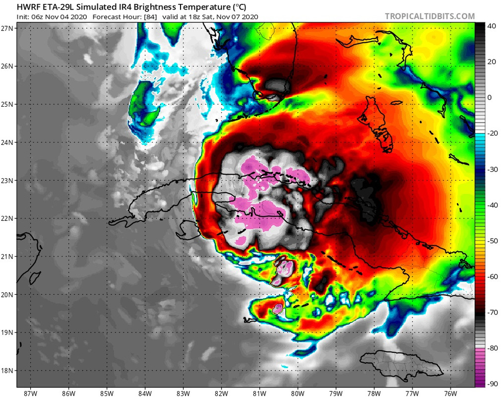
Here's the 06z HWRF with a 977mb hurricane over Palm Beach County in 99hrs. for what it's worth.

0 likes
-
AutoPenalti
- Category 5
- Posts: 4091
- Age: 29
- Joined: Mon Aug 17, 2015 4:16 pm
- Location: Ft. Lauderdale, Florida
Re: ATL: ETA - Models
TheStormExpert wrote:Here's the 06z HWRF with a 977mb hurricane over Palm Beach County in 99hrs. for what it's worth.
https://i.imgur.com/Cnp5Hco.png
Typical Summer time afternoon storm?
3 likes
The posts in this forum are NOT official forecasts and should not be used as such. They are just the opinion of the poster and may or may not be backed by sound meteorological data. They are NOT endorsed by any professional institution or STORM2K. For official information, please refer to products from the NHC and NWS.
Model Runs Cheat Sheet:
GFS (5:30 AM/PM, 11:30 AM/PM)
HWRF, GFDL, UKMET, NAVGEM (6:30-8:00 AM/PM, 12:30-2:00 AM/PM)
ECMWF (1:45 AM/PM)
TCVN is a weighted averaged
-
TheStormExpert
Re: ATL: ETA - Models
AutoPenalti wrote:TheStormExpert wrote:Here's the 06z HWRF with a 977mb hurricane over Palm Beach County in 99hrs. for what it's worth.
https://i.imgur.com/Cnp5Hco.png
Typical Summer time afternoon storm?
It's an outlier at the moment so take it with a grain of salt.
0 likes

Re: ATL: ETA - Models
TheStormExpert wrote:AutoPenalti wrote:TheStormExpert wrote:Here's the 06z HWRF with a 977mb hurricane over Palm Beach County in 99hrs. for what it's worth.
https://i.imgur.com/Cnp5Hco.png
Typical Summer time afternoon storm?
It's an outlier at the moment so take it with a grain of salt.
Technically, the HWRF was also an outlier showing a Cat 4/5 hurricane on approach to Nicaragua.
It’s been performing pretty well this year, so nothing can be excluded from it just yet. Everything depends on what Eta looks like in a few days after moving off of CA.
4 likes
Irene '11 Sandy '12 Hermine '16 5/15/2018 Derecho Fay '20 Isaias '20 Elsa '21 Henri '21 Ida '21
I am only a meteorology enthusiast who knows a decent amount about tropical cyclones. Look to the professional mets, the NHC, or your local weather office for the best information.
I am only a meteorology enthusiast who knows a decent amount about tropical cyclones. Look to the professional mets, the NHC, or your local weather office for the best information.
-
TheStormExpert
Re: ATL: ETA - Models
aspen wrote:TheStormExpert wrote:AutoPenalti wrote:Typical Summer time afternoon storm?
It's an outlier at the moment so take it with a grain of salt.
Technically, the HWRF was also an outlier showing a Cat 4/5 hurricane on approach to Nicaragua.
It’s been performing pretty well this year, so nothing can be excluded from it just yet. Everything depends on what Eta looks like in a few days after moving off of CA.
We need to wait and see the state of Eta when it re-emerges into the Caribbean in a few days. I'm sure one of these models might be correct, but which one?
0 likes

Re: ATL: ETA - Models
Blown Away wrote:SFLcane wrote:06z hwrf and Hmon are west.
I think you mean east.
Or Both
0 likes
Personal Forecast Disclaimer:
The posts in this forum are NOT official forecast and should not be used as such. They are just the opinion of the poster and may or may not be backed by sound meteorological data. They are NOT endorsed by any professional institution or storm2k.org. For official information, please refer to the NHC and NWS products.
The posts in this forum are NOT official forecast and should not be used as such. They are just the opinion of the poster and may or may not be backed by sound meteorological data. They are NOT endorsed by any professional institution or storm2k.org. For official information, please refer to the NHC and NWS products.
-
Blown Away
- S2K Supporter
- Posts: 10253
- Joined: Wed May 26, 2004 6:17 am
Re: ATL: ETA - Models

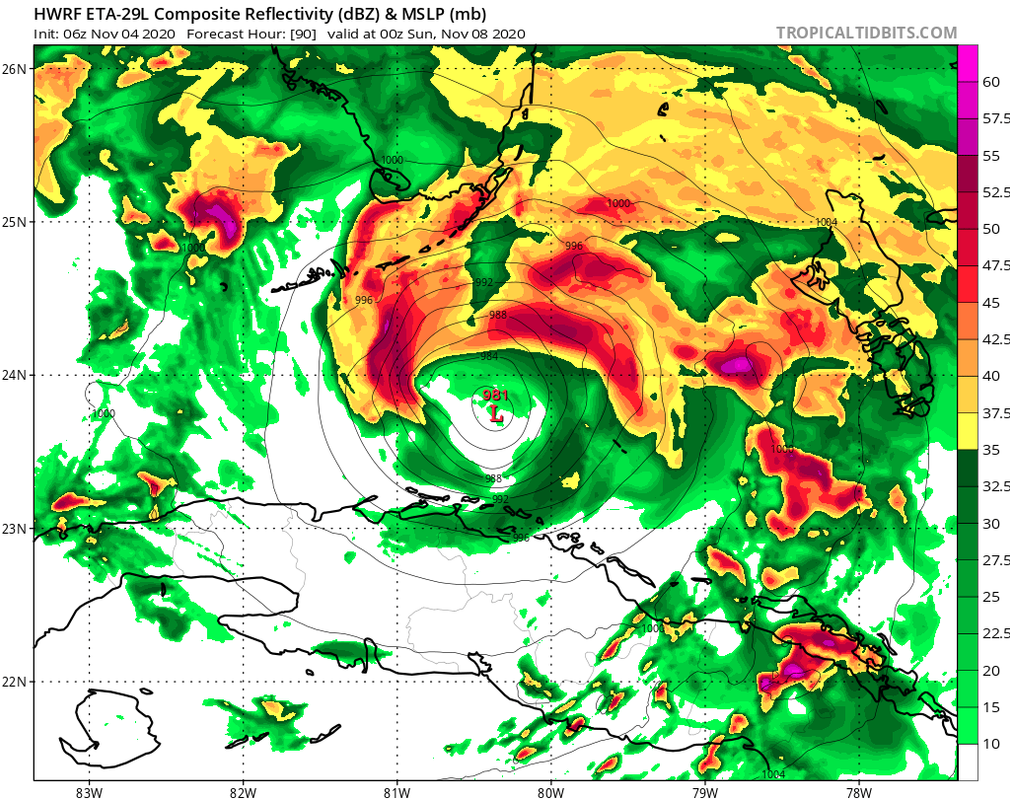
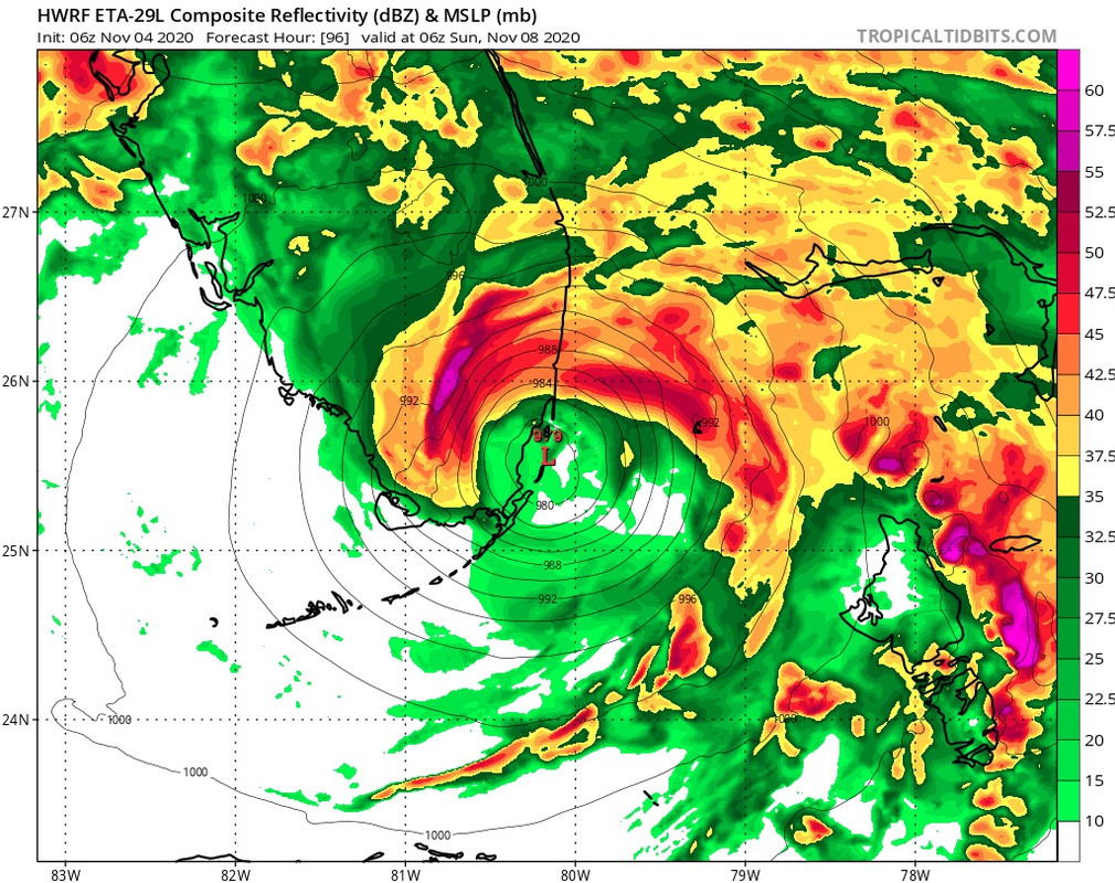
06z Navgem
3 likes
Hurricane Eye Experience: David 79, Irene 99, Frances 04, Jeanne 04, Wilma 05… Hurricane Brush Experience: Andrew 92, Erin 95, Floyd 99, Matthew 16, Irma 17, Ian 22, Nicole 22…
-
AdamFirst

- S2K Supporter
- Posts: 2490
- Age: 36
- Joined: Thu Aug 14, 2008 10:54 am
- Location: Port Saint Lucie, FL
Re: ATL: ETA - Models
NAVGEM has been pretty consistent in that Bahamas to FL solution. Obviously it's just the NAVGEM but the models are all honing in on a westerly course at one point or another
3 likes
Dolphins Marlins Canes Golden Panthers HEAT
Andrew 1992 - Irene 1999 - Frances 2004 - Jeanne 2004 - Wilma 2005 - Fay 2008 - Isaac 2012 - Matthew 2016 - Irma 2017 - Dorian 2019 - Ian 2022 - Nicole 2022 - Milton 2024
Andrew 1992 - Irene 1999 - Frances 2004 - Jeanne 2004 - Wilma 2005 - Fay 2008 - Isaac 2012 - Matthew 2016 - Irma 2017 - Dorian 2019 - Ian 2022 - Nicole 2022 - Milton 2024
Re: ATL: ETA - Models
Center reformation will be key. I don't think it'll take until Friday for us to see a new circulation brewing, and probably not as far west as models would indicate. The next 48 hours will be interesting as it will shift the track east or west depending on where this occurs...
1 likes
Andrew (1992), Irene (1999), Frances (2004), Katrina (2005), Wilma (2005), Fay (2008), Irma (2017), Eta (2020), Ian (2022)
Who is online
Users browsing this forum: No registered users and 8 guests