EPAC: DOLORES - Remnants
Moderator: S2k Moderators
-
Kingarabian

- S2K Supporter

- Posts: 16373
- Joined: Sat Aug 08, 2009 3:06 am
- Location: Honolulu, Hawaii
-
Kingarabian
- S2K Supporter
- Posts: 16373
- Joined: Sat Aug 08, 2009 3:06 am
- Location: Honolulu, Hawaii
Re: EPAC: DOLORES - Tropical Storm

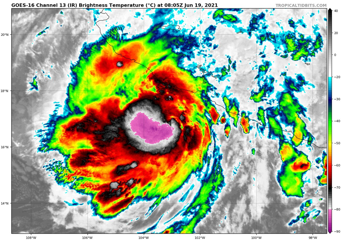
Hope it's not bombing out. This frame looks to be a T4.0 now.
0 likes
RIP Kobe Bryant
-
Kingarabian
- S2K Supporter
- Posts: 16373
- Joined: Sat Aug 08, 2009 3:06 am
- Location: Honolulu, Hawaii
Re: EPAC: DOLORES - Tropical Storm
Tropical Storm Dolores Discussion Number 5
NWS National Hurricane Center Miami FL EP042021
400 AM CDT Sat Jun 19 2021
Dolores appears to be in another bursting pattern coincident with
the diurnal max this morning, as deep convection and cold cloud tops
have increased in coverage and intensity near the estimated
low-level center. A distinct curved band has also formed along the
storm's southern semicircle. The latest Dvorak subjective intensity
estimates were both T3.5/55 kt from TAFB and SAB, though the most
recent CIMSS-ADT intensity estimate was only T3.0/45 kt.
Unfortunately there has not been no recent microwave or
scatterometer data available to better assess the inner core
structure of the cyclone. Blending the subjective and objective
intensity estimates, the maximum sustained winds was raised to 50 kt
for this advisory, though this value may be conservative.
Dolores appears to be making a slow right turn as the storm
gradually accelerates while it rounds the western side of a
mid-level ridge, currently moving at 330/9 kt. A gradual
acceleration toward the north-northwest is anticipated until
landfall with this motion continuing until the storm dissipates over
the high terrain of western Mexico. The latest track forecast is a
bit to the east of the previous forecast cycle but remains in close
agreement with the multi-model consensus. On this track, Dolores is
expected to reach the Mexican coastline in the next 12 h and push
far inland thereafter. Given the eastward adjustment in the forecast
track, the government of Mexico has extended the hurricane watch
further to the southeast for this advisory.
Environmental conditions are expected to remain favorable for
additional intensification right up until landfall along the Mexican
coast, close to Punta San Telmo, in about 12 h. The current forecast
intensity for 60 kt in 12 hours is a bit higher than the guidance
consensus, as few models already have the storm inland at that time.
Rapid weakening is forecast as Dolores moves inland over western
Mexico thereafter and the storm will likely dissipate by 36 h, if
not sooner.
Key Messages:
1. Dolores is expected to continue strengthening today up until
landfall, and it could be near hurricane strength when it reaches
the coast of west-central Mexico by this afternoon. A tropical
storm warning and a hurricane watch are in effect for portions of
the southwestern and west-central coasts of Mexico.
2. Heavy rains are forecast over coastal sections of the Mexican
states of Oaxaca, Guerrero, Michoacan, Colima, Jalisco, and Nayarit
during the next few days, which could result in life-threatening
flash flooding and mudslides.
FORECAST POSITIONS AND MAX WINDS
INIT 19/0900Z 17.0N 103.1W 50 KT 60 MPH
12H 19/1800Z 18.6N 103.6W 60 KT 70 MPH...NEAR THE COAST
24H 20/0600Z 21.4N 104.4W 30 KT 35 MPH...INLAND
36H 20/1800Z...DISSIPATED
$$
Forecaster Papin/Blake
0 likes
RIP Kobe Bryant
-
Yellow Evan

- Professional-Met

- Posts: 16242
- Age: 27
- Joined: Fri Jul 15, 2011 12:48 pm
- Location: Henderson, Nevada/Honolulu, HI
- Contact:
Re: EPAC: DOLORES - Tropical Storm
684
WTPZ34 KNHC 191151
TCPEP4
BULLETIN
Tropical Storm Dolores Intermediate Advisory Number 5A
NWS National Hurricane Center Miami FL EP042021
700 AM CDT Sat Jun 19 2021
...DOLORES STILL GRADUALLY STRENGTHENING AND NEARING LANDFALL ALONG
THE WESTERN MICHOACAN OR COLIMA COAST...
...HEAVY RAIN BANDS CONTINUE TO STREAM ONSHORE...
SUMMARY OF 700 AM CDT...1200 UTC...INFORMATION
----------------------------------------------
LOCATION...17.9N 103.4W
ABOUT 80 MI...125 KM W OF LAZARO CARDENAS MEXICO
ABOUT 95 MI...155 KM SE OF MANZANILLO MEXICO
MAXIMUM SUSTAINED WINDS...65 MPH...100 KM/H
PRESENT MOVEMENT...NNW OR 340 DEGREES AT 13 MPH...20 KM/H
MINIMUM CENTRAL PRESSURE...994 MB...29.35 INCHES
WATCHES AND WARNINGS
--------------------
CHANGES WITH THIS ADVISORY:
None.
SUMMARY OF WATCHES AND WARNINGS IN EFFECT:
A Tropical Storm Warning is in effect for...
* Lazaro Cardenas to Cabo Corrientes Mexico
A Hurricane Watch is in effect for...
* Lazaro Cardenas to Cabo Corrientes Mexico
A Tropical Storm Watch is in effect for...
* North of Cabo Corrientes to Escuinapa Mexico
A Tropical Storm Warning means that tropical storm conditions are
expected somewhere within the warning area, in this case within the
next 12 to 24 hours.
A Hurricane Watch means that hurricane conditions are possible
within the watch area, in this case within the next 12 hours.
A Tropical Storm Watch means that tropical storm conditions are
possible within the watch area, generally within 48 hours.
For storm information specific to your area, please monitor
products issued by your national meteorological service.
DISCUSSION AND OUTLOOK
----------------------
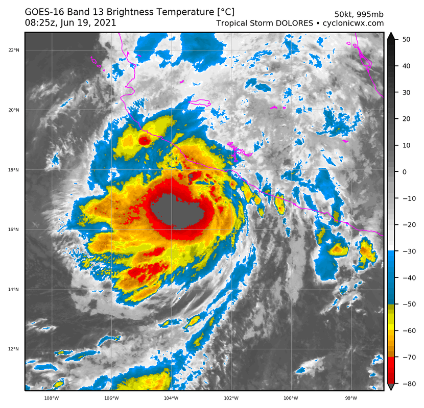
At 700 AM CDT (1200 UTC), the center of Tropical Storm Dolores was
located near latitude 17.9 North, longitude 103.4 West. Dolores is
moving faster toward the north-northwest near 13 mph (20 km/h), and
this motion is expected to continue until landfall. Dolores is
forecast to make landfall along the southwestern coast of Mexico
within the next few hours.
Maximum sustained winds have increased to near 65 mph (100 km/h)
with higher gusts. Additional intensification is possible prior to
landfall, and Dolores is forecast to be near hurricane intensity
when it makes landfall later today. Rapid weakening is expected
after landfall, and Dolores is expected to dissipate by the end of
the weekend.
Tropical-storm-force winds extend outward up to 105 miles (165 km)
from the center.
The estimated minimum central pressure is 994 mb (29.35 inches).
HAZARDS AFFECTING LAND
----------------------
Key messages for Tropical Storm Dolores can be found in the
Tropical Cyclone Discussion under AWIPS header MIATCDEP4, WMO
header WTPZ44 KNHC, and on the web
at www.hurricanes.gov/graphics_ep4.shtml?key_messages.
WIND: Tropical storm conditions are likely occurring within the
warning area, and outside preparations should be complete.
Hurricane conditions are possible within the hurricane watch area
within the next few hours. Tropical storm conditions are possible
within the tropical storm watch area this evening through Sunday
morning.
RAINFALL: Tropical Storm Dolores will produce heavy rainfall of 6
to 10 inches with isolated maximum amounts of 15 inches across
coastal sections of the Mexican states of Guerrero, Michoacan,
Colima, Jalisco, and Nayarit through the weekend. This will likely
produce life threatening flash flooding and mudslides.
Additionally, 3 to 5 inches of rainfall with isolated maximum
amounts of 8 inches are expected for western Oaxaca, as well as
southern Sinaloa. This may produce life threatening flash flooding.
STORM SURGE: A storm surge is expected to produce coastal flooding
near and to the east of where the center makes landfall. Near the
coast, the surge will be accompanied by large and destructive waves.
SURF: Swells generated by Dolores will affect portions of the
southwestern coast of Mexico through the weekend. These swells are
likely to cause life-threatening surf and rip current conditions.
Please consult products from your local weather office.
NEXT ADVISORY
-------------
Next complete advisory at 1000 AM CDT.
$$
Forecaster Berg
WTPZ34 KNHC 191151
TCPEP4
BULLETIN
Tropical Storm Dolores Intermediate Advisory Number 5A
NWS National Hurricane Center Miami FL EP042021
700 AM CDT Sat Jun 19 2021
...DOLORES STILL GRADUALLY STRENGTHENING AND NEARING LANDFALL ALONG
THE WESTERN MICHOACAN OR COLIMA COAST...
...HEAVY RAIN BANDS CONTINUE TO STREAM ONSHORE...
SUMMARY OF 700 AM CDT...1200 UTC...INFORMATION
----------------------------------------------
LOCATION...17.9N 103.4W
ABOUT 80 MI...125 KM W OF LAZARO CARDENAS MEXICO
ABOUT 95 MI...155 KM SE OF MANZANILLO MEXICO
MAXIMUM SUSTAINED WINDS...65 MPH...100 KM/H
PRESENT MOVEMENT...NNW OR 340 DEGREES AT 13 MPH...20 KM/H
MINIMUM CENTRAL PRESSURE...994 MB...29.35 INCHES
WATCHES AND WARNINGS
--------------------
CHANGES WITH THIS ADVISORY:
None.
SUMMARY OF WATCHES AND WARNINGS IN EFFECT:
A Tropical Storm Warning is in effect for...
* Lazaro Cardenas to Cabo Corrientes Mexico
A Hurricane Watch is in effect for...
* Lazaro Cardenas to Cabo Corrientes Mexico
A Tropical Storm Watch is in effect for...
* North of Cabo Corrientes to Escuinapa Mexico
A Tropical Storm Warning means that tropical storm conditions are
expected somewhere within the warning area, in this case within the
next 12 to 24 hours.
A Hurricane Watch means that hurricane conditions are possible
within the watch area, in this case within the next 12 hours.
A Tropical Storm Watch means that tropical storm conditions are
possible within the watch area, generally within 48 hours.
For storm information specific to your area, please monitor
products issued by your national meteorological service.
DISCUSSION AND OUTLOOK
----------------------
At 700 AM CDT (1200 UTC), the center of Tropical Storm Dolores was
located near latitude 17.9 North, longitude 103.4 West. Dolores is
moving faster toward the north-northwest near 13 mph (20 km/h), and
this motion is expected to continue until landfall. Dolores is
forecast to make landfall along the southwestern coast of Mexico
within the next few hours.
Maximum sustained winds have increased to near 65 mph (100 km/h)
with higher gusts. Additional intensification is possible prior to
landfall, and Dolores is forecast to be near hurricane intensity
when it makes landfall later today. Rapid weakening is expected
after landfall, and Dolores is expected to dissipate by the end of
the weekend.
Tropical-storm-force winds extend outward up to 105 miles (165 km)
from the center.
The estimated minimum central pressure is 994 mb (29.35 inches).
HAZARDS AFFECTING LAND
----------------------
Key messages for Tropical Storm Dolores can be found in the
Tropical Cyclone Discussion under AWIPS header MIATCDEP4, WMO
header WTPZ44 KNHC, and on the web
at www.hurricanes.gov/graphics_ep4.shtml?key_messages.
WIND: Tropical storm conditions are likely occurring within the
warning area, and outside preparations should be complete.
Hurricane conditions are possible within the hurricane watch area
within the next few hours. Tropical storm conditions are possible
within the tropical storm watch area this evening through Sunday
morning.
RAINFALL: Tropical Storm Dolores will produce heavy rainfall of 6
to 10 inches with isolated maximum amounts of 15 inches across
coastal sections of the Mexican states of Guerrero, Michoacan,
Colima, Jalisco, and Nayarit through the weekend. This will likely
produce life threatening flash flooding and mudslides.
Additionally, 3 to 5 inches of rainfall with isolated maximum
amounts of 8 inches are expected for western Oaxaca, as well as
southern Sinaloa. This may produce life threatening flash flooding.
STORM SURGE: A storm surge is expected to produce coastal flooding
near and to the east of where the center makes landfall. Near the
coast, the surge will be accompanied by large and destructive waves.
SURF: Swells generated by Dolores will affect portions of the
southwestern coast of Mexico through the weekend. These swells are
likely to cause life-threatening surf and rip current conditions.
Please consult products from your local weather office.
NEXT ADVISORY
-------------
Next complete advisory at 1000 AM CDT.
$$
Forecaster Berg
0 likes
-
Yellow Evan
- Professional-Met
- Posts: 16242
- Age: 27
- Joined: Fri Jul 15, 2011 12:48 pm
- Location: Henderson, Nevada/Honolulu, HI
- Contact:
Re: EPAC: DOLORES - Tropical Storm
Appears to have an actual CDO now. Wouldn’t surprise me if Recon finds a hurricane if still offshore.
0 likes
-
Yellow Evan
- Professional-Met
- Posts: 16242
- Age: 27
- Joined: Fri Jul 15, 2011 12:48 pm
- Location: Henderson, Nevada/Honolulu, HI
- Contact:
Re: EPAC: DOLORES - Tropical Storm

Actually this probably makes it onshore before Recon arrives.
0 likes
-
Sciencerocks
- Category 5

- Posts: 10186
- Age: 40
- Joined: Thu Jul 06, 2017 1:51 am


Re: EPAC: DOLORES - Tropical Storm
Will the end result of this storm bring rain into Texas or will it last long? Even after all the rain we have had recently, my yard could use some.
0 likes
Alicia, Rita, Ike, Harvey and Beryl...moved to Splendora lol
-
Yellow Evan
- Professional-Met
- Posts: 16242
- Age: 27
- Joined: Fri Jul 15, 2011 12:48 pm
- Location: Henderson, Nevada/Honolulu, HI
- Contact:
-
cycloneye

- Admin

- Posts: 149550
- Age: 69
- Joined: Thu Oct 10, 2002 10:54 am
- Location: San Juan, Puerto Rico
Re: EPAC: DOLORES - Tropical Storm
BULLETIN
Tropical Storm Dolores Advisory Number 6
NWS National Hurricane Center Miami FL EP042021
1000 AM CDT Sat Jun 19 2021
...DOLORES MAKING LANDFALL NEAR THE MICHOACAN/COLIMA BORDER JUST
BELOW HURRICANE INTENSITY...
...LIFE-THREATENING FLASH FLOODING AND MUDSLIDES LIKELY ACROSS
PORTIONS OF SOUTHWESTERN AND WEST-CENTRAL MEXICO...
SUMMARY OF 1000 AM CDT...1500 UTC...INFORMATION
-----------------------------------------------
LOCATION...18.6N 103.7W
ABOUT 50 MI...75 KM SE OF MANZANILLO MEXICO
ABOUT 105 MI...170 KM WNW OF LAZARO CARDENAS MEXICO
MAXIMUM SUSTAINED WINDS...70 MPH...110 KM/H
PRESENT MOVEMENT...NNW OR 335 DEGREES AT 13 MPH...20 KM/H
MINIMUM CENTRAL PRESSURE...990 MB...29.24 INCHES
WATCHES AND WARNINGS
--------------------
CHANGES WITH THIS ADVISORY:
None.
SUMMARY OF WATCHES AND WARNINGS IN EFFECT:
A Tropical Storm Warning is in effect for...
* Lazaro Cardenas to Cabo Corrientes Mexico
A Hurricane Watch is in effect for...
* Lazaro Cardenas to Cabo Corrientes Mexico
A Tropical Storm Watch is in effect for...
* North of Cabo Corrientes to Escuinapa Mexico
A Tropical Storm Warning means that tropical storm conditions are
expected somewhere within the warning area.
A Hurricane Watch means that hurricane conditions are possible
within the watch area, in this case within the next few hours.
A Tropical Storm Watch means that tropical storm conditions are
possible within the watch area, in this case within 24 hours.
For storm information specific to your area, please monitor
products issued by your national meteorological service.
DISCUSSION AND OUTLOOK
----------------------
At 1000 AM CDT (1500 UTC), the center of Tropical Storm Dolores was
making landfall on the southwestern coast of Mexico near latitude
18.6 North, longitude 103.7 West. Dolores is moving toward the
north-northwest near 13 mph (20 km/h), and this general motion is
expected to continue through tonight. On the forecast track, the
center of Dolores will move farther inland across western
Michoacan, Colima, Jalisco, and Nayarit.
Maximum sustained winds have increased to near 70 mph (110 km/h)
with higher gusts. Now that Dolores is making landfall, rapid
weakening is expected later today and tonight while the center
moves inland over the mountainous terrain of west-central Mexico.
Dolores is likely to dissipate over west-central Mexico on Sunday.
Tropical-storm-force winds extend outward up to 90 miles (150 km)
from the center.
The estimated minimum central pressure is 990 mb (29.24 inches).
HAZARDS AFFECTING LAND
----------------------
Key messages for Tropical Storm Dolores can be found in the
Tropical Cyclone Discussion under AWIPS header MIATCDEP4, WMO
header WTPZ44 KNHC, and on the web
at http://www.hurricanes.gov/graphics_ep4. ... y_messages.
WIND: Tropical storm conditions are occurring within the warning
area and will continue to spread inland across portions of
west-central Mexico through tonight. Hurricane conditions,
especially in gusts, are still possible within the hurricane watch
area for a few more hours. Tropical storm conditions are possible
within the tropical storm watch area this evening through Sunday
morning.
RAINFALL: Tropical Storm Dolores will produce heavy rainfall of 6
to 10 inches with isolated maximum amounts of 15 inches across
coastal sections of the Mexican states of Guerrero, Michoacan,
Colima, Jalisco, Nayarit, and southern Sinaloa through the weekend.
This will likely produce life threatening flash flooding and
mudslides.
Additionally, 2 to 4 inches of rainfall with isolated maximum
amounts of 6 inches is expected for western Oaxaca.
STORM SURGE: A storm surge is expected to produce coastal flooding
near and to the east of where the center makes landfall. Near the
coast, the surge will be accompanied by large and destructive waves.
SURF: Swells generated by Dolores will affect portions of the
southwestern coast of Mexico through the weekend. These swells are
likely to cause life-threatening surf and rip current conditions.
Please consult products from your local weather office.
NEXT ADVISORY
-------------
Next intermediate advisory at 100 PM CDT.
Next complete advisory at 400 PM CDT.
$$
Forecaster Berg
Tropical Storm Dolores Discussion Number 6
NWS National Hurricane Center Miami FL EP042021
1000 AM CDT Sat Jun 19 2021
Satellite imagery indicates that Dolores's center is moving onshore
near the Michoacan/Colima border a little to the northwest of Punta
San Telmo, Mexico. Within its last few hours over water, Dolores's
satellite presentation continued to improve, and an SSMIS microwave
pass from 1155 UTC showed that the storm has a large, well-defined
mid-level eye surrounded by a nearly closed eyewall. Dolores
appears to be very close to hurricane strength, and its current
intensity is set at 60 kt as a compromise between estimates of T3.5
and T4.5 from TAFB and SAB, respectively.
Dolores has been accelerating while approaching the coast, and its
current motion is estimated to be toward the north-northwest (335
degrees) at 11 kt. With the center forecast to move farther inland
through the day, the mountainous terrain of west-central Mexico is
expected to disrupt the surface circulation, and the model guidance
generally shows the low-level vorticity dissipating in about 12
hours, or less. To maintain continuity with previous forecasts,
the NHC official forecast maintains a track for 24 hours, showing
Dolores weakening fast and degenerating to a remnant low over
west-central Mexico by this time tomorrow. However, it is entirely
possible that the surface circulation will have dissipated by
Sunday morning, with the associated rains continuing to spread
northward with the remnant mid-level circulation.
Even though Dolores is making landfall, the hurricane watch for the
coast of Mexico is being maintained on this advisory since gusts to
hurricane force could be occurring to the east of where the center
is moving onshore.
Key Messages:
1. Even though Dolores had made landfall, tropical storm conditions
are still occurring within the tropical storm warning area and will
spread farther inland across west-central Mexico through the day
and tonight. Hurricane conditions, especially in gusts, are still
possible for a few more hours within the hurricane watch area.
2. Heavy rains are forecast over coastal sections of the Mexican
states of Oaxaca, Guerrero, Michoacan, Colima, Jalisco, Nayarit,
and southern Sinaloa through the weekend, which could result in
life-threatening flash flooding and mudslides.
FORECAST POSITIONS AND MAX WINDS
INIT 19/1500Z 18.6N 103.7W 60 KT 70 MPH...ON THE COAST
12H 20/0000Z 20.4N 104.2W 40 KT 45 MPH...INLAND
24H 20/1200Z 21.8N 104.6W 30 KT 35 MPH...POST-TROP/INLAND
36H 21/0000Z...DISSIPATED
$$
Forecaster Berg
0 likes
Visit the Caribbean-Central America Weather Thread where you can find at first post web cams,radars
and observations from Caribbean basin members Click Here
and observations from Caribbean basin members Click Here
-
Yellow Evan
- Professional-Met
- Posts: 16242
- Age: 27
- Joined: Fri Jul 15, 2011 12:48 pm
- Location: Henderson, Nevada/Honolulu, HI
- Contact:
Re: EPAC: DOLORES - Tropical Storm
Win for the GFS/HWRF here. Though honestly shouldn’t this be a hurricane at landfall given SAB’s T4.5?
0 likes
-
Yellow Evan
- Professional-Met
- Posts: 16242
- Age: 27
- Joined: Fri Jul 15, 2011 12:48 pm
- Location: Henderson, Nevada/Honolulu, HI
- Contact:

-
Yellow Evan
- Professional-Met
- Posts: 16242
- Age: 27
- Joined: Fri Jul 15, 2011 12:48 pm
- Location: Henderson, Nevada/Honolulu, HI
- Contact:
-
Sciencerocks
- Category 5
- Posts: 10186
- Age: 40
- Joined: Thu Jul 06, 2017 1:51 am

-
galaxy401

- Category 5
- Posts: 2446
- Age: 30
- Joined: Sat Aug 25, 2012 9:04 pm
- Location: Casa Grande, Arizona
Re: EPAC: DOLORES - Tropical Storm
Dolores really sped up right before landfall. I guess she didn't want recon to come. But because of that, we might never get a hurricane upgrade for it.
0 likes
Got my eyes on moving right into Hurricane Alley: Florida.
-
Astromanía
- Category 2

- Posts: 796
- Age: 27
- Joined: Sat Aug 25, 2018 10:34 pm
- Location: Monterrey, N.L, México
Re: EPAC: DOLORES - Tropical Storm
Two comfirmed deaths due to a mudslide in Oaxaca state for now
1 likes
-
Stormybajan

- Category 1

- Posts: 453
- Joined: Thu May 20, 2021 3:21 pm
- Location: Windward Islands
Re: EPAC: DOLORES - Tropical Storm
Astromanía wrote:Two comfirmed deaths due to a mudslide in Oaxaca state for now
Already? thats sad man hope everyone over there being affected stays safe
1 likes
Sad West Indies and Manchester United fan ⚽️
-
Yellow Evan
- Professional-Met
- Posts: 16242
- Age: 27
- Joined: Fri Jul 15, 2011 12:48 pm
- Location: Henderson, Nevada/Honolulu, HI
- Contact:
Re: EPAC: DOLORES - Tropical Storm
Astromanía wrote:Two comfirmed deaths due to a mudslide in Oaxaca state for now
Source? Not finding this in Mexico media.
1 likes
-
Sciencerocks
- Category 5
- Posts: 10186
- Age: 40
- Joined: Thu Jul 06, 2017 1:51 am

-
Astromanía
- Category 2
- Posts: 796
- Age: 27
- Joined: Sat Aug 25, 2018 10:34 pm
- Location: Monterrey, N.L, México
Re: EPAC: DOLORES - Tropical Storm
Yellow Evan wrote:Astromanía wrote:Two comfirmed deaths due to a mudslide in Oaxaca state for now
Source? Not finding this in Mexico media.
The video is in spanish
[youtube]https://youtu.be/58GpqdguTNI[/youtube]
0 likes
Who is online
Users browsing this forum: No registered users and 13 guests