https://twitter.com/pppapin/status/1408564251984158724
EPAC: ENRIQUE - Remnants
Moderator: S2k Moderators
-
Yellow Evan

- Professional-Met

- Posts: 16240
- Age: 27
- Joined: Fri Jul 15, 2011 12:48 pm
- Location: Henderson, Nevada/Honolulu, HI
- Contact:
-
cycloneye

- Admin

- Posts: 149508
- Age: 69
- Joined: Thu Oct 10, 2002 10:54 am
- Location: San Juan, Puerto Rico
Re: EPAC: ENRIQUE - Tropical Storm
65 mph
BULLETIN
Tropical Storm Enrique Intermediate Advisory Number 3A
NWS National Hurricane Center Miami FL EP052021
700 PM CDT Fri Jun 25 2021
...ENRIQUE QUICKLY STRENGTHENING...
...EXPECTED TO BECOME A HURRICANE LATER TONIGHT OR SATURDAY...
SUMMARY OF 700 PM CDT...0000 UTC...INFORMATION
----------------------------------------------
LOCATION...16.1N 103.8W
ABOUT 205 MI...325 KM S OF MANZANILLO MEXICO
ABOUT 320 MI...520 KM SSE OF CABO CORRIENTES MEXICO
MAXIMUM SUSTAINED WINDS...65 MPH...100 KM/H
PRESENT MOVEMENT...WNW OR 290 DEGREES AT 8 MPH...13 KM/H
MINIMUM CENTRAL PRESSURE...996 MB...29.41 INCHES
WATCHES AND WARNINGS
--------------------
CHANGES WITH THIS ADVISORY:
None.
SUMMARY OF WATCHES AND WARNINGS IN EFFECT:
A Tropical Storm Warning is in effect for...
* Zihuatanejo to Cabo Corrientes Mexico
A Tropical Storm Watch is in effect for...
* Cabo Corrientes to San Blas Mexico
A Tropical Storm Warning means that tropical storm conditions are
expected somewhere within the warning area.
A Tropical Storm Watch means that tropical storm conditions are
possible within the watch area, generally within 48 hours.
For storm information specific to your area, please monitor
products issued by your national meteorological service.
DISCUSSION AND OUTLOOK
----------------------
At 700 PM CDT (0000 UTC), the center of Tropical Storm Enrique was
located near latitude 16.1 North, longitude 103.8 West. Enrique is
moving toward the west-northwest near 8 mph (13 km/h). The storm is
forecast to gradually slow down with a turn toward the northwest
expected to occur by Sunday. On the forecast track, the core of
Enrique is expected to remain offshore roughly parallel to the
southwestern coast of Mexico during the next few days.
Maximum sustained winds have increased to near 65 mph (100 km/h)
with higher gusts. Additional strengthening is forecast, and
Enrique is likely to become a hurricane later tonight or on
Saturday.
Tropical-storm-force winds extend outward up to 140 miles (220 km)
from the center.
The estimated minimum central pressure is 996 mb (29.41 inches).
HAZARDS AFFECTING LAND
----------------------
Key messages for Tropical Storm Enrique can be found in the
Tropical Cyclone Discussion under AWIPS header MIATCDEP5, WMO
header WTPZ45 KNHC, and on the web
at www.hurricanes.gov/graphics_ep5.shtml?key_messages.
WIND: Tropical storm conditions are likely occuring in the
eastern portions of the warning area. These winds are expected to
spread westward within the warning area tonight and through
the weekend. Tropical storm conditions are possible in the watch
area on Sunday.
RAINFALL: Enrique is expected to produce total rain accumulations
of 4 to 8 inches with possible isolated maximum amounts of 12
inches through Sunday. These rains could cause life-threatening
flash floods and mudslides over portions of southwestern Mexico.
SURF: Swells generated by Enrique will affect the southwestern
coast of Mexico during the next few days. These swells are likely to
cause life-threatening surf and rip current conditions. Please
consult products from your local weather office.
NEXT ADVISORY
-------------
Next complete advisory at 1000 PM CDT.
$$
Forecaster Brown/Berg
0 likes
Visit the Caribbean-Central America Weather Thread where you can find at first post web cams,radars
and observations from Caribbean basin members Click Here
and observations from Caribbean basin members Click Here
-
Kingarabian

- S2K Supporter

- Posts: 16366
- Joined: Sat Aug 08, 2009 3:06 am
- Location: Honolulu, Hawaii
Re: EPAC: ENRIQUE - Tropical Storm
The SSMIS F-18 pass also missed. Last hope is the lower resolution SSMI F-15 and possibly an SSMIS F-17 pass in a few more hours.
0 likes
RIP Kobe Bryant
-
Yellow Evan
- Professional-Met
- Posts: 16240
- Age: 27
- Joined: Fri Jul 15, 2011 12:48 pm
- Location: Henderson, Nevada/Honolulu, HI
- Contact:
Re: EPAC: ENRIQUE - Tropical Storm
Might be a hurricane but with earlier ASCAT I’m still a bit spooked. Would be nice if we had microwave to confirm but I suspect there is one right now.
1 likes
-
Yellow Evan
- Professional-Met
- Posts: 16240
- Age: 27
- Joined: Fri Jul 15, 2011 12:48 pm
- Location: Henderson, Nevada/Honolulu, HI
- Contact:
Re: EPAC: ENRIQUE - Tropical Storm
TXPZ24 KNES 252359
TCSENP
A. 05E (ENRIQUE)
B. 25/2330Z
C. 16.0N
D. 103.5W
E. THREE/GOES-E
F. T3.5/3.5
G. IR/EIR/VIS
H. REMARKS...SYSTEM HAS 9/10 BANDING RESULTING IN A DT OF 3.5. MET
IS 3.0 AND PT IS 3.5. SYSTEM INTENSIFIED RAPIDLY THUS CONSTRAINTS WERE
BROKEN. FT IS BASED ON PT DUE TO BANDING FEATURES NOT BEING CLEAR CUT.
I. ADDL POSITIONS
NIL
...PATEL
0 likes
-
cycloneye
- Admin
- Posts: 149508
- Age: 69
- Joined: Thu Oct 10, 2002 10:54 am
- Location: San Juan, Puerto Rico
Re: EPAC: ENRIQUE - Tropical Storm
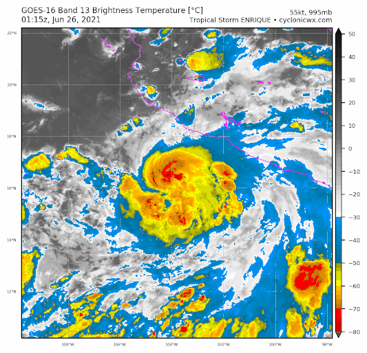
EP, 05, 2021062600, , BEST, 0, 162N, 1038W, 55, 995, TS, 50, NEQ, 30, 20, 0, 20, 1007, 180, 25, 0, 0, E, 0, , 0, 0, ENRIQUE, D
0 likes
Visit the Caribbean-Central America Weather Thread where you can find at first post web cams,radars
and observations from Caribbean basin members Click Here
and observations from Caribbean basin members Click Here
-
Yellow Evan
- Professional-Met
- Posts: 16240
- Age: 27
- Joined: Fri Jul 15, 2011 12:48 pm
- Location: Henderson, Nevada/Honolulu, HI
- Contact:
Re: EPAC: ENRIQUE - Tropical Storm
* GFS version *
* EAST PACIFIC 2021 SHIPS INTENSITY FORECAST *
* IR SAT DATA AVAILABLE, OHC AVAILABLE *
* ENRIQUE EP052021 06/26/21 00 UTC *
TIME (HR) 0 6 12 18 24 36 48 60 72 84 96 108 120 132 144 156 168
V (KT) NO LAND 55 63 73 82 89 97 90 78 66 56 44 36 28 20 N/A N/A N/A
V (KT) LAND 55 63 73 82 89 97 90 78 66 56 44 36 28 20 N/A N/A N/A
V (KT) LGEM 55 62 69 75 79 83 77 71 67 61 55 47 39 32 26 21 17
Storm Type TROP TROP TROP TROP TROP TROP TROP TROP TROP TROP TROP TROP TROP TROP TROP TROP TROP
SHEAR (KT) 5 4 5 12 13 14 17 7 7 8 11 15 20 22 25 27 27
SHEAR ADJ (KT) 5 7 1 -2 -4 3 -2 1 0 -2 2 0 0 -2 -1 -2 -1
SHEAR DIR 350 292 175 133 98 91 92 92 53 111 120 136 139 141 133 138 138
SST (C) 29.4 29.4 29.3 29.3 29.2 29.0 28.6 27.9 26.4 24.7 24.1 23.1 21.9 21.9 22.3 22.2 21.4
POT. INT. (KT) 158 158 156 155 154 152 148 141 126 107 101 90 78 77 82 82 74
200 MB T (C) -53.0 -53.3 -53.4 -52.8 -52.5 -53.0 -52.1 -53.1 -52.7 -53.2 -52.9 -53.3 -53.1 -53.2 -53.1 -53.1 -52.8
200 MB VXT (C) 0.3 0.5 0.4 0.3 0.6 0.7 0.3 0.8 0.5 0.5 0.3 0.3 0.2 0.3 0.1 0.4 0.3
TH_E DEV (C) 7 5 4 5 4 3 4 3 4 2 3 2 2 1 1 0 0
700-500 MB RH 80 82 81 79 80 81 76 77 71 69 64 64 58 60 55 52 43
MODEL VTX (KT) 15 17 20 21 22 22 16 12 9 9 6 6 5 5 3 4 3
850 MB ENV VOR 51 58 51 64 68 77 97 89 76 57 60 34 40 29 18 21 16
200 MB DIV 132 126 117 153 160 85 129 96 33 11 5 2 -15 -11 5 7 -13
700-850 TADV -3 -2 0 -2 -1 -11 -6 1 0 0 -1 0 0 0 1 2 5
LAND (KM) 227 240 261 263 256 224 199 195 271 241 172 126 131 177 239 293 330
LAT (DEG N) 16.2 16.5 16.7 16.9 17.1 17.7 18.6 19.5 20.4 20.9 21.4 21.8 22.3 xx.x xx.x xx.x xx.x
LONG(DEG W) 103.8 104.5 105.2 105.5 105.7 106.2 106.7 107.3 108.3 109.1 109.6 110.3 111.1 xxx.x xxx.x xxx.x xxx.x
STM SPEED (KT) 8 7 5 3 3 5 5 6 5 4 4 4 4 3 4 6 7
HEAT CONTENT 21 20 19 17 16 16 15 10 2 0 0 0 0 0 0 0 0
FORECAST TRACK FROM OFCI INITIAL HEADING/SPEED (DEG/KT):295/ 9 CX,CY: -7/ 4
T-12 MAX WIND: 40 PRESSURE OF STEERING LEVEL (MB): 566 (MEAN=587)
GOES IR BRIGHTNESS TEMP. STD DEV. 50-200 KM RAD: 6.4 (MEAN=14.5)
% GOES IR PIXELS WITH T < -20 C 50-200 KM RAD: 97.0 (MEAN=65.0)
PRELIM RI PROB (DV .GE. 35 KT IN 36 HR): 69.4
INDIVIDUAL CONTRIBUTIONS TO INTENSITY CHANGE
6 12 18 24 36 48 60 72 84 96 108 120 132 144 156 168
------------------------------------------------------------------------------
SAMPLE MEAN CHANGE 0. 0. 1. 1. 1. 2. 1. 1. 0. -0. -1. -2. -2. -3. -4. -4.
SST POTENTIAL 1. 2. 3. 4. 6. 7. 8. 9. 8. 7. 5. 1. -3. -7. -11. -15.
VERTICAL SHEAR MAG 0. 1. 1. 1. 1. 1. 1. 2. 2. 2. 2. 0. -2. -4. -7. -9.
VERTICAL SHEAR ADJ -0. -1. -1. -0. -1. -1. -0. -0. -0. -0. -0. -0. 0. 0. 0. 0.
VERTICAL SHEAR DIR -0. -0. -1. -0. -0. -0. -0. -1. -1. -2. -2. -2. -2. -2. -2. -2.
PERSISTENCE 3. 5. 5. 5. 4. 3. 2. 2. 1. 2. 1. 1. 1. 1. 1. 1.
200/250 MB TEMP. 0. 0. -0. -0. -1. -1. -1. -1. -1. -0. 0. 1. 2. 3. 4. 4.
THETA_E EXCESS -0. -0. -0. -1. -2. -3. -4. -4. -5. -6. -7. -7. -8. -9. -11. -13.
700-500 MB RH 0. 0. 0. 1. 1. 1. 1. 2. 2. 2. 2. 2. 2. 2. 3. 3.
MODEL VTX TENDENCY 1. 3. 5. 6. 6. 1. -3. -7. -8. -12. -11. -12. -11. -11. -10. -10.
850 MB ENV VORTICITY 0. 0. 0. 0. 0. -0. -0. -1. -1. -1. -1. -1. -1. -1. -1. -1.
200 MB DIVERGENCE 0. 1. 1. 2. 2. 3. 6. 6. 6. 6. 4. 3. 2. 0. -0. -1.
850-700 T ADVEC 0. 0. 0. 0. 0. -0. -0. -0. -0. -0. -0. -0. -0. -0. -0. -0.
ZONAL STORM MOTION 0. 0. 0. 0. 0. 0. 0. 0. 0. 0. -0. -0. -0. -0. -0. 0.
STEERING LEVEL PRES -0. -0. -0. -0. -0. -0. -0. -0. -0. -0. -0. -0. -0. -0. -0. -0.
DAYS FROM CLIM. PEAK -0. -0. -0. -0. -0. -0. -1. -1. -2. -2. -2. -2. -3. -3. -4. -5.
GOES PREDICTORS 1. 2. 3. 3. 3. 2. 3. 2. 2. 2. 2. 3. 2. 2. 1. 1.
OCEAN HEAT CONTENT 0. 0. 0. -0. -0. -0. -0. -0. -0. -0. 0. 0. 1. 2. 3. 4.
RI POTENTIAL 2. 5. 9. 13. 21. 19. 11. 3. -3. -7. -11. -12. -12. -12. -12. -11.
------------------------------------------------------------------------------
TOTAL CHANGE 8. 18. 27. 34. 42. 35. 23. 11. 1. -11. -19. -27. -35. -43. -49. -57.
CURRENT MAX WIND (KT): 55. LAT, LON: 16.2 103.8
** 2021 E. Pacific RI INDEX EP052021 ENRIQUE 06/26/21 00 UTC **
(SHIPS-RII PREDICTOR TABLE for 30 KT OR MORE MAXIMUM WIND INCREASE IN NEXT 24-h)
Predictor Value RI Predictor Range Scaled Value(0-1) % Contribution
POT = MPI-VMAX (KT) : 100.9 40.5 to 149.3 0.56 12.7
12 HR PERSISTENCE (KT) : 15.0 -22.0 to 44.0 0.56 14.6
D200 (10**7s-1) : 137.6 -33.0 to 159.5 0.89 18.8
850-200 MB SHEAR (KT) : 7.8 19.6 to 1.3 0.64 13.1
MAXIMUM WIND (KT) : 55.0 22.5 to 132.0 0.92 14.7
STD DEV OF IR BR TEMP : 6.4 37.8 to 2.1 0.88 12.6
BL DRY-AIR FLUX (W/M2) : 36.8 800.8 to -82.5 0.86 -13.9
HEAT CONTENT (KJ/CM2) : 18.6 2.7 to 106.7 0.15 1.8
%area of TPW <45 mm upshear : 0.0 56.6 to 0.0 1.00 4.5
2nd PC OF IR BR TEMP : 0.2 2.2 to -2.3 0.44 1.1
SHIPS Prob RI for 20kt/ 12hr RI threshold= 56% is 8.9 times climatological mean ( 6.3%)
SHIPS Prob RI for 25kt/ 24hr RI threshold= 90% is 7.2 times climatological mean (12.5%)
SHIPS Prob RI for 30kt/ 24hr RI threshold= 80% is 9.3 times climatological mean ( 8.6%)
SHIPS Prob RI for 35kt/ 24hr RI threshold= 72% is 11.6 times climatological mean ( 6.2%)
SHIPS Prob RI for 40kt/ 24hr RI threshold= 53% is 12.6 times climatological mean ( 4.2%)
SHIPS Prob RI for 45kt/ 36hr RI threshold= 63% is 9.4 times climatological mean ( 6.7%)
SHIPS Prob RI for 55kt/ 48hr RI threshold= 43% is 7.4 times climatological mean ( 5.9%)
SHIPS Prob RI for 65kt/ 72hr RI threshold= 13% is 2.8 times climatological mean ( 4.7%)
Matrix of RI probabilities
------------------------------------------------------------------------------
RI (kt / h) | 20/12 | 25/24 | 30/24 | 35/24 | 40/24 | 45/36 | 55/48 |65/72
------------------------------------------------------------------------------
SHIPS-RII: 55.8% 89.9% 80.1% 71.8% 52.9% 62.9% 43.5% 13.2%
Logistic: 49.5% 62.0% 53.6% 42.8% 12.9% 40.2% 10.5% 2.5%
Bayesian: 53.0% 39.5% 48.0% 33.3% 2.2% 9.7% 1.2% 0.1%
Consensus: 52.8% 63.8% 60.6% 49.3% 22.7% 37.6% 18.4% 5.3%
DTOPS: 33.0% 73.0% 49.0% 34.0% 22.0% 41.0% 15.0% 0.0%
## ANNULAR HURRICANE INDEX (AHI) EP052021 ENRIQUE 06/26/21 00 UTC ##
## STORM NOT ANNULAR, SCREENING STEP FAILED, NPASS=3 NFAIL=4 ##
## AHI= 0 (AHI OF 100 IS BEST FIT TO ANN. STRUC., 1 IS MARGINAL, 0 IS NOT ANNULAR) ##
0 likes
-
Sciencerocks
- Category 5

- Posts: 10186
- Age: 40
- Joined: Thu Jul 06, 2017 1:51 am

-
Yellow Evan
- Professional-Met
- Posts: 16240
- Age: 27
- Joined: Fri Jul 15, 2011 12:48 pm
- Location: Henderson, Nevada/Honolulu, HI
- Contact:


Re: EPAC: ENRIQUE - Tropical Storm
That certainly explains its current convective structure. Just needs some more deep convection to rotate to the NW quadrant to close off the eyewall.
1 likes
Irene '11 Sandy '12 Hermine '16 5/15/2018 Derecho Fay '20 Isaias '20 Elsa '21 Henri '21 Ida '21
I am only a meteorology enthusiast who knows a decent amount about tropical cyclones. Look to the professional mets, the NHC, or your local weather office for the best information.
I am only a meteorology enthusiast who knows a decent amount about tropical cyclones. Look to the professional mets, the NHC, or your local weather office for the best information.
-
Kingarabian
- S2K Supporter
- Posts: 16366
- Joined: Sat Aug 08, 2009 3:06 am
- Location: Honolulu, Hawaii
Re: EPAC: ENRIQUE - Tropical Storm
aspen wrote:
That certainly explains its current convective structure. Just needs some more deep convection to rotate to the NW quadrant to close off the eyewall.
Still needs to work it's way up, but very likely it's closed off at the lower levels. Probably is a hurricane.
0 likes
RIP Kobe Bryant
-
ElectricStorm

- Category 5
- Posts: 5147
- Age: 25
- Joined: Tue Aug 13, 2019 11:23 pm
- Location: Norman, OK
Re: EPAC: ENRIQUE - Tropical Storm
Got a feeling this thing is about to bomb out...
0 likes
B.S Meteorology, University of Oklahoma '25
Please refer to the NHC, NWS, or SPC for official information.
Please refer to the NHC, NWS, or SPC for official information.
Re: EPAC: ENRIQUE - Tropical Storm
Weather Dude wrote:Got a feeling this thing is about to bomb out...
If the HWRF and its simulated IR structure forecast are right, then Enrique might actually be struggling for some time.
0 likes
Irene '11 Sandy '12 Hermine '16 5/15/2018 Derecho Fay '20 Isaias '20 Elsa '21 Henri '21 Ida '21
I am only a meteorology enthusiast who knows a decent amount about tropical cyclones. Look to the professional mets, the NHC, or your local weather office for the best information.
I am only a meteorology enthusiast who knows a decent amount about tropical cyclones. Look to the professional mets, the NHC, or your local weather office for the best information.
-
cycloneye
- Admin
- Posts: 149508
- Age: 69
- Joined: Thu Oct 10, 2002 10:54 am
- Location: San Juan, Puerto Rico
Re: EPAC: ENRIQUE - Tropical Storm
BULLETIN
Tropical Storm Enrique Advisory Number 4
NWS National Hurricane Center Miami FL EP052021
1000 PM CDT Fri Jun 25 2021
...ENRIQUE FORECAST TO RAPIDLY STRENGTHEN INTO A HURRICANE
TONIGHT OR SATURDAY...
SUMMARY OF 1000 PM CDT...0300 UTC...INFORMATION
-----------------------------------------------
LOCATION...16.3N 104.1W
ABOUT 185 MI...300 KM S OF MANZANILLO MEXICO
ABOUT 300 MI...485 KM SSE OF CABO CORRIENTES MEXICO
MAXIMUM SUSTAINED WINDS...65 MPH...100 KM/H
PRESENT MOVEMENT...WNW OR 295 DEGREES AT 9 MPH...15 KM/H
MINIMUM CENTRAL PRESSURE...995 MB...29.39 INCHES
WATCHES AND WARNINGS
--------------------
CHANGES WITH THIS ADVISORY:
None.
SUMMARY OF WATCHES AND WARNINGS IN EFFECT:
A Tropical Storm Warning is in effect for...
* Zihuatanejo to Cabo Corrientes Mexico
A Tropical Storm Watch is in effect for...
* Cabo Corrientes to San Blas Mexico
A Tropical Storm Warning means that tropical storm conditions are
expected somewhere within the warning area.
A Tropical Storm Watch means that tropical storm conditions are
possible within the watch area, generally within 48 hours.
For storm information specific to your area, please monitor
products issued by your national meteorological service.
DISCUSSION AND OUTLOOK
----------------------
At 1000 PM CDT (0300 UTC), the center of Tropical Storm Enrique was
located near latitude 16.3 North, longitude 104.1 West. Enrique is
moving toward the west-northwest near 9 mph (15 km/h). The storm is
forecast to gradually slow down and turn toward the northwest
Saturday night or Sunday, and then continue on a northwesterly
heading through Monday. On the forecast track, the core of
Enrique is expected to remain offshore roughly parallel to the
southwestern coast of Mexico during the next two to three days.
Maximum sustained winds are near 65 mph (100 km/h) with higher
gusts. Rapid strengthening is forecast during the next day or so,
and Enrique is likely to become a hurricane later tonight or on
Saturday.
Tropical-storm-force winds extend outward up to 140 miles (220 km)
from the center.
The estimated minimum central pressure is 995 mb (29.39 inches).
HAZARDS AFFECTING LAND
----------------------
Key messages for Tropical Storm Enrique can be found in the
Tropical Cyclone Discussion under AWIPS header MIATCDEP5, WMO
header WTPZ45 KNHC, and on the web
at www.hurricanes.gov/graphics_ep5.shtml?key_messages.
WIND: Tropical storm conditions are likely occuring in the
eastern portions of the warning area. These winds are expected to
spread westward within the warning area tonight and through
the weekend. Tropical storm conditions are possible in the watch
area on Sunday.
RAINFALL: Enrique is expected to produce total rain accumulations
of 4 to 8 inches with possible isolated maximum amounts of 12
inches through Sunday. These rains could cause life-threatening
flash floods and mudslides over portions of southwestern Mexico.
SURF: Swells generated by Enrique will affect the southwestern
coast of Mexico during the next few days. These swells are likely to
cause life-threatening surf and rip current conditions. Please
consult products from your local weather office.
NEXT ADVISORY
-------------
Next intermediate advisory at 100 AM CDT.
Next complete advisory at 400 AM CDT.
$$
Forecaster Brown
Tropical Storm Enrique Discussion Number 4
NWS National Hurricane Center Miami FL EP052021
1000 PM CDT Fri Jun 25 2021
Enrique's cloud pattern has continued to improve since this
afternoon. There has been a notable increase in banding, and the
Central Dense Overcast has become more symmetric. In addition, a
SSMIS microwave overpass from shortly before 0000 UTC revealed an
improved inner core structure with a band of deep convection
wrapping about three-quarters of the way around the center. The
latest subjective Dvorak T-numbers from SAB and TAFB are T3.5 (55
kt) and T3.0 (45 kt), respectively. Given the improvement in
structure the intensity was increased to 55 kt on the 0000 UTC
intermediate advisory and remains at that value for this advisory.
The tropical storm is forecast to remain within an environment of
low vertical wind shear and over warm sea surface temperatures
during the next 24 to 36 hours. Those favorable conditions along
with Enrique's improved inner core structure are likely to result
in a period of rapid strengthening during the next day or so. In
fact, the SHIPS guidance explicitly calls for rapid strengthening,
and the latest NHC forecast follows suit. The new NHC intensity
forecast calls for a peak intensity near major hurricane strength
in 36 hours and lies between the SHIPS model and the slightly lower
HCCA and ICON consensus aids. After 36-48 h, increasing shear,
and possibly cooler upwelled waters, are likely to induce steady
weakening throughout the remainder of the forecast period.
Enrique continues to move west-northwestward or 295/8 kt. A
mid-level ridge to the north of the storm is forecast to weaken
over the next day or so which should cause Enrique to slow down and
bend northwestward between 24 and 60 hours. After that time, the
ridge is expected to re-strengthen causing the tropical cyclone to
turn west-northwestward once again. There has been little overall
change to the track guidance this cycle, and the updated NHC
forecast is not very different from before. It should be noted
that the GFS and HWRF models depict a sharper northward turn over
the weekend and bring the center of Enrique somewhat closer to the
southwestern coast of Mexico than the remainder of the guidance,
however the most recent run of the HWRF has trended westward during
the early portion of the forecast.
Key Messages:
1. The outer rainbands of Enrique are likely to produce heavy rains
across portions of southwestern Mexico during the next couple of
days, which could cause life-threatening flash floods and mudslides.
2. Tropical-storm-force winds are expected across portions of
southwestern Mexico tonight and this weekend, and a Tropical Storm
Warning is in effect for a portion of that area.
3. Swells generated by Enrique are expected to affect the
southwestern coast of Mexico during the next few days. These swells
could cause life-threatening surf and rip currents.
FORECAST POSITIONS AND MAX WINDS
INIT 26/0300Z 16.3N 104.1W 55 KT 65 MPH
12H 26/1200Z 16.7N 105.2W 70 KT 80 MPH
24H 27/0000Z 17.1N 105.9W 85 KT 100 MPH
36H 27/1200Z 17.8N 106.3W 95 KT 110 MPH
48H 28/0000Z 18.9N 106.8W 90 KT 105 MPH
60H 28/1200Z 19.8N 107.5W 75 KT 85 MPH
72H 29/0000Z 20.5N 108.3W 65 KT 75 MPH
96H 30/0000Z 21.5N 109.7W 50 KT 60 MPH
120H 01/0000Z 22.5N 111.0W 35 KT 40 MPH
$$
Forecaster Brown
2 likes
Visit the Caribbean-Central America Weather Thread where you can find at first post web cams,radars
and observations from Caribbean basin members Click Here
and observations from Caribbean basin members Click Here
-
Kingarabian
- S2K Supporter
- Posts: 16366
- Joined: Sat Aug 08, 2009 3:06 am
- Location: Honolulu, Hawaii
-
Kingarabian
- S2K Supporter
- Posts: 16366
- Joined: Sat Aug 08, 2009 3:06 am
- Location: Honolulu, Hawaii
Re: EPAC: ENRIQUE - Tropical Storm
ADT 9.0 is lower than SSD's ADT 8.2:
9.0
8.2:
9.0
UW - CIMSS
ADVANCED DVORAK TECHNIQUE
ADT-Version 9.0
Tropical Cyclone Intensity Algorithm
----- Current Analysis -----
Date : 26 JUN 2021 Time : 022022 UTC
Lat : 16:08:06 N Lon : 103:57:07 W
CI# /Pressure/ Vmax
3.3 / 992.8mb/ 51.0kt
Final T# Adj T# Raw T#
3.3 3.6 3.9
Center Temp : -55.4C Cloud Region Temp : -59.6C
Scene Type : UNIFORM CDO CLOUD REGION
Subtropical Adjustment : OFF
Extratropical Adjustment : OFF
Positioning Method : FORECAST INTERPOLATION
Ocean Basin : EAST PACIFIC
Dvorak CI > MSLP Conversion Used : CKZ Method
Tno/CI Rules : Constraint Limits : 0.2T/hour
Weakening Flag : OFF
Rapid Dissipation Flag : OFF
C/K/Z MSLP Estimate Inputs :
- Average 34 knot radii : 75nmi
- Environmental MSLP : 1007mb
Satellite Name : GOES16
Satellite Viewing Angle : 37.9 degrees
8.2:
2021JUN26 023000 4.1 983.9 67.4 4.1 4.1 4.1 NO LIMIT OFF OFF -66.16 -61.92 UNIFRM N/A 2.8 16.28 104.04 FCST GOES16 38.3
0 likes
RIP Kobe Bryant
-
USTropics
- Professional-Met
- Posts: 2739
- Joined: Sun Aug 12, 2007 3:45 am
- Location: Florida State University
Re: EPAC: ENRIQUE - Tropical Storm
Consecutive gravity waves and an expanding CDO, definitely signs that RI is occurring this evening:

6 likes
-
Kingarabian
- S2K Supporter
- Posts: 16366
- Joined: Sat Aug 08, 2009 3:06 am
- Location: Honolulu, Hawaii


Re: EPAC: ENRIQUE - Tropical Storm
NHC issuing advisories for the Eastern Pacific on Hurricane Enrique
2 likes
-
Kingarabian
- S2K Supporter
- Posts: 16366
- Joined: Sat Aug 08, 2009 3:06 am
- Location: Honolulu, Hawaii
Re: EPAC: ENRIQUE - Tropical Storm
Hurricane Enrique Discussion Number 5
NWS National Hurricane Center Miami FL EP052021
400 AM CDT Sat Jun 26 2021
The cloud pattern of Enrique has continued to become better
organized since the last advisory, with a well-defined central
dense overcast and a small, but persistent, area of cloud tops
colder than -80C that may be the top of an eyewall. Satellite
intensity estimates include subjective Dvorak estimates of 55 kt
from TAFB and SAB and an objective estimate of 65 kt from the CIMSS
ADT. The initial intensity is increased to 65 kt based mainly on
the latter estimate. Although the cyclone continues to intensify,
cirrus cloud motions to the west of the center suggest some shear
is occurring.
The initial motion is 290/7. A mid-level ridge to the north of the
storm is forecast to weaken over the next day or so which should
cause Enrique to slow down and bend northwestward between 24-60 h.
After that time, the ridge is expected to re-strengthen, causing
the tropical cyclone to turn west-northwestward once again. The
track guidance has shifted a little to the right since the last
advisory during the first 72 h, and the GFS model continues to show
a sharper northward turn that would bring the center closer to the
coast of Mexico. The new forecast track is also shifted a little to
the right during the first 72 h, but it lies west of the various
consensus models. Any subsequent adjustment of the forecast track
to the right/east could require a hurricane watch for portions of
the southwestern coast of Mexico later today.
Enrique is forecast to remain within an environment of low vertical
wind shear and over warm sea surface temperatures during the next
24 to 36 hours. Therefore, continued steady to rapid strengthening
is likely as indicated by the Rapid Intensification Indices of the
SHIPS model. The new intensity forecast calls for a peak intensity
of 95 kt at 36 h, which is near the high end of the intensity
guidance. After 36 h, increasing shear and decreasing sea surface
temperatures along the forecast track should cause a steady
weakening.
Key Messages:
1. The outer rainbands of Enrique are likely to produce heavy rains
across a portion of southwestern Mexico during the next couple days,
which would likely cause life-threatening flash flooding and
mudslides.
2. Tropical-storm-force winds are expected across portions of
southwestern Mexico today and this weekend, and a Tropical Storm
Warning is in effect for a portion of that area.
3. Swells generated by Enrique are expected to affect the
southwestern coast of Mexico during the next few days. These swells
could cause life-threatening surf and rip currents.
FORECAST POSITIONS AND MAX WINDS
INIT 26/0900Z 16.7N 104.7W 65 KT 75 MPH
12H 26/1800Z 16.9N 105.5W 75 KT 85 MPH
24H 27/0600Z 17.5N 106.1W 90 KT 105 MPH
36H 27/1800Z 18.5N 106.4W 95 KT 110 MPH
48H 28/0600Z 19.5N 107.1W 90 KT 105 MPH
60H 28/1800Z 20.2N 107.8W 75 KT 85 MPH
72H 29/0600Z 20.7N 108.5W 65 KT 75 MPH
96H 30/0600Z 21.5N 109.5W 45 KT 50 MPH
120H 01/0600Z 22.5N 111.0W 30 KT 35 MPH
$$
Forecaster Beven
1 likes
RIP Kobe Bryant
Who is online
Users browsing this forum: No registered users and 28 guests