
The HWRF is up to its old tricks with a 960s Cat 2/3 in the Caribbean. It has very minimal gain in latitude for 95L until the last moment, when it’s like “you know what screw Haiti” and suddenly 95L takes a sharp turn north, making landfall as a 90-95 kt Cat 2.
The main takeaway from this run is that if 95L gains latitude much more slowly than the GFS/Euro show and it makes it into the Caribbean without hitting the GAs, then it could have the opportunity to become significant. The same would probably be true if it stays north of the big islands instead of south.
ATL: GRACE - Models
Moderator: S2k Moderators
Re: ATL: 95L - Models
3 likes
Irene '11 Sandy '12 Hermine '16 5/15/2018 Derecho Fay '20 Isaias '20 Elsa '21 Henri '21 Ida '21
I am only a meteorology enthusiast who knows a decent amount about tropical cyclones. Look to the professional mets, the NHC, or your local weather office for the best information.
I am only a meteorology enthusiast who knows a decent amount about tropical cyclones. Look to the professional mets, the NHC, or your local weather office for the best information.
Re: ATL: 95L - Models
At the end of the 12Z HWRF 92L barely clips the southern tip of the DR and looks like it will make landfall in Western Haiti.
0 likes
-
Spacecoast

- Category 2

- Posts: 773
- Joined: Thu Aug 31, 2017 2:03 pm
Re: ATL: 95L - Models
12z ECMF - a few less member, and a few less yellow members

12z GEFS

latest spaghetti - GEFS plus globals plus OFCL
(white is consensus)

12z GEFS
latest spaghetti - GEFS plus globals plus OFCL
(white is consensus)
0 likes
Re: ATL: 95L - Models
18z GFS has a stronger vortex, and it misses Hispaniola with 95L tracking north into the Bahamas once it reaches Puerto Rico.
By 7-9 days out, 95L gets strung out over the Bahamas, suggesting shear might be present at the time (shear forecasts on the models, as we all know, are rather unreliable more than a few days out). The GFS is probably overdoing the effects of shear due to not having a well-developed TC at that time and location.
By 7-9 days out, 95L gets strung out over the Bahamas, suggesting shear might be present at the time (shear forecasts on the models, as we all know, are rather unreliable more than a few days out). The GFS is probably overdoing the effects of shear due to not having a well-developed TC at that time and location.
0 likes
Irene '11 Sandy '12 Hermine '16 5/15/2018 Derecho Fay '20 Isaias '20 Elsa '21 Henri '21 Ida '21
I am only a meteorology enthusiast who knows a decent amount about tropical cyclones. Look to the professional mets, the NHC, or your local weather office for the best information.
I am only a meteorology enthusiast who knows a decent amount about tropical cyclones. Look to the professional mets, the NHC, or your local weather office for the best information.
-
tolakram
- Admin

- Posts: 20186
- Age: 62
- Joined: Sun Aug 27, 2006 8:23 pm
- Location: Florence, KY (name is Mark)
Re: ATL: 95L - Models
18Z HWRF loses Fred and loses 95L.
0 likes
M a r k
- - - - -
Join us in chat: Storm2K Chatroom Invite. Android and IOS apps also available.
The posts in this forum are NOT official forecasts and should not be used as such. Posts are NOT endorsed by any professional institution or STORM2K.org. For official information and forecasts, please refer to NHC and NWS products.
-
tolakram
- Admin
- Posts: 20186
- Age: 62
- Joined: Sun Aug 27, 2006 8:23 pm
- Location: Florence, KY (name is Mark)
Re: ATL: 95L - Models
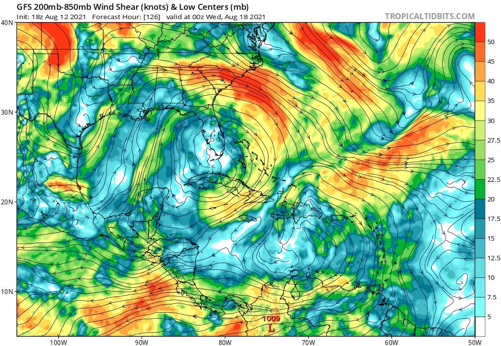
Check out the monster high pressure and 50kts winds at 200mb in 126 hours. This is partly ripping up 95L. What is that?

0 likes
M a r k
- - - - -
Join us in chat: Storm2K Chatroom Invite. Android and IOS apps also available.
The posts in this forum are NOT official forecasts and should not be used as such. Posts are NOT endorsed by any professional institution or STORM2K.org. For official information and forecasts, please refer to NHC and NWS products.
- - - - -
Join us in chat: Storm2K Chatroom Invite. Android and IOS apps also available.
The posts in this forum are NOT official forecasts and should not be used as such. Posts are NOT endorsed by any professional institution or STORM2K.org. For official information and forecasts, please refer to NHC and NWS products.
Re: ATL: 95L - Models
tolakram wrote:18Z HWRF loses Fred and loses 95L.
Seems like the 18z HWRF is playing Where’s Waldo with the two systems and failing miserably. Given how poorly it initialized Fred, I’m guessing all of the 18z HWRF runs are problematic.
0 likes
Irene '11 Sandy '12 Hermine '16 5/15/2018 Derecho Fay '20 Isaias '20 Elsa '21 Henri '21 Ida '21
I am only a meteorology enthusiast who knows a decent amount about tropical cyclones. Look to the professional mets, the NHC, or your local weather office for the best information.
I am only a meteorology enthusiast who knows a decent amount about tropical cyclones. Look to the professional mets, the NHC, or your local weather office for the best information.
-
gatorcane

- S2K Supporter

- Posts: 23708
- Age: 48
- Joined: Sun Mar 13, 2005 3:54 pm
- Location: Boca Raton, FL
Re: ATL: 95L - Models
tolakram wrote:Check out the monster high pressure and 50kts winds at 200mb in 126 hours. This is partly ripping up 95L. What is that?
https://i.imgur.com/Ien0RrC.png
Not sure but here is the corresponding shear chart. Looks hostile across the Bahamas and SW Atlantic. This is only 5 days from now so certainly possible:
0 likes
-
Hypercane_Kyle

- Category 5

- Posts: 3465
- Joined: Sat Mar 07, 2015 7:58 pm
- Location: Cape Canaveral, FL
Re: ATL: 95L - Models
00z GFS coming in a good bit stronger through 72 hours.
1 likes
My posts are my own personal opinion, defer to the National Hurricane Center (NHC) and other NOAA products for decision making during hurricane season.
-
lsuhurricane
- Category 1

- Posts: 270
- Joined: Tue Aug 15, 2017 2:53 pm
Re: ATL: 95L - Models
Signs of life on this GFS run….lookout
Ridging off the Carolinas keeps a strengthening hurricane stalled east of the Bahamas. This run is sure to open some eyeballs
Ridging off the Carolinas keeps a strengthening hurricane stalled east of the Bahamas. This run is sure to open some eyeballs
1 likes
-
Hypercane_Kyle
- Category 5
- Posts: 3465
- Joined: Sat Mar 07, 2015 7:58 pm
- Location: Cape Canaveral, FL
Re: ATL: 95L - Models
lsuhurricane wrote:Signs of life on this GFS run….lookout
Ridging off the Carolinas keeps a strengthening hurricane stalled east of the Bahamas. This run is sure to open some eyeballs
That's until the 06z run drops it entirely lol
0 likes
My posts are my own personal opinion, defer to the National Hurricane Center (NHC) and other NOAA products for decision making during hurricane season.
-
Category5Kaiju

- Category 5
- Posts: 4338
- Joined: Thu Dec 24, 2020 12:45 pm
- Location: Seattle during the summer, Phoenix during the winter
Re: ATL: 95L - Models
The 0z GFS run is literally like a weaker version of Dorian. Freeport and Great Abaco almost certainly do not need this.
4 likes
Unless explicitly stated, all information in my posts is based on my own opinions and observations. Tropical storms and hurricanes can be extremely dangerous. Refer to an accredited weather research agency or meteorologist if you need to make serious decisions regarding an approaching storm.
-
AxaltaRacing24
- Category 5
- Posts: 1774
- Age: 25
- Joined: Wed Jul 27, 2016 11:14 am
- Location: Jupiter, FL
Re: ATL: 95L - Models
Category5Kaiju wrote:The 0z GFS run is literally like a weaker version of Dorian. Freeport and Great Abaco almost certainly do not need this.
Some potential tracks this year literally mimic Dorian's "what if" scenario had it kept going west, so hopefully we don't see that come into play this early in the season.
0 likes
Re: ATL: 95L - Models
GFS stalls 95L near the Bahamas and it just keeps strengthing down to 946 MB.
0 likes
-
AxaltaRacing24
- Category 5
- Posts: 1774
- Age: 25
- Joined: Wed Jul 27, 2016 11:14 am
- Location: Jupiter, FL
Re: ATL: 95L - Models
Hypercane_Kyle wrote:lsuhurricane wrote:Signs of life on this GFS run….lookout
Ridging off the Carolinas keeps a strengthening hurricane stalled east of the Bahamas. This run is sure to open some eyeballs
That's until the 06z run drops it entirely lol
Can't drop it once it develops.
0 likes
Re: ATL: 95L - Models
This run just seems to be asking what if Dorian went to the Carolinas at full strength
0 likes
-
Hurricaneman

- Category 5
- Posts: 7404
- Age: 45
- Joined: Tue Aug 31, 2004 3:24 pm
- Location: central florida
Re: ATL: 95L - Models
My thoughts on the GFS is wow and hopefully Florida keeps its guard up because that’s a serious hurricane in that location and not far from the east coast
0 likes
-
AxaltaRacing24
- Category 5
- Posts: 1774
- Age: 25
- Joined: Wed Jul 27, 2016 11:14 am
- Location: Jupiter, FL
Re: ATL: 95L - Models
Hurricaneman wrote:My thoughts on the GFS is wow and hopefully Florida keeps its guard up because that’s a serious hurricane in that location and not far from the east coast
That would likely be a cat 5... and with that track, I am more worried about the Bahamas who just took the bullet for us in 2019.
0 likes
-
Hurricaneman
- Category 5
- Posts: 7404
- Age: 45
- Joined: Tue Aug 31, 2004 3:24 pm
- Location: central florida
Re: ATL: 95L - Models
lsuhurricane wrote:Signs of life on this GFS run….lookout
Ridging off the Carolinas keeps a strengthening hurricane stalled east of the Bahamas. This run is sure to open some eyeballs
Verbatim is very close ridge wise to being a nasty hit for Florida to the Carolinas
1 likes
Re: ATL: 95L - Models
944 min on the GFS heading towards Outer Banks
Icon says blob into South Florida but has a developing storm SE of Bermuda
Icon says blob into South Florida but has a developing storm SE of Bermuda
Last edited by caneseddy on Thu Aug 12, 2021 11:50 pm, edited 2 times in total.
0 likes
Who is online
Users browsing this forum: No registered users and 21 guests