
The recurve on the GFS is happening over 240 hours out. Compared to the past two runs its not even a similar setup. No point in speculating on recurve potential right now.
At hour 144 GFS ensembles are generally a tad stronger and further SW than the 06z and 00z run.
ATL: PETER - Models
Moderator: S2k Moderators
Re: ATL: INVEST 95L - Models
3 likes
-
toad strangler

- S2K Supporter

- Posts: 4546
- Joined: Sun Jul 28, 2013 3:09 pm
- Location: Earth
- Contact:
Re: ATL: INVEST 95L - Models
Buried into the GA's at 6z and back to Larryish once again. Back and forth like a yo yo. I was correct that there would be a near 100% chance of a vastly different outcome and here it is lol. Near 100% it's vastly different again at 18z
1 likes
My Weather Station
https://www.wunderground.com/dashboard/pws/KFLPORTS603
https://www.wunderground.com/dashboard/pws/KFLPORTS603

Re: ATL: INVEST 95L - Models
12z models now showing more favorable environment toward the end of the runs. This is such a fluid forecast not only with the intensity but the track. Very early to call this an OTS. This one has my attention.
3 likes
The following post is NOT an official forecast and should not be used as such. It is just the opinion of the poster and may or may not be backed by sound meteorological data. It is NOT endorsed by any professional institution including storm2k.org For Official Information please refer to the NHC and NWS products.
-
SFLcane

- S2K Supporter
- Posts: 10281
- Age: 48
- Joined: Sat Jun 05, 2010 1:44 pm
- Location: Lake Worth Florida
Re: ATL: INVEST 95L - Models
Incoming trof to save the day. Being almost Oct it will be hard for any ridge to hold. Many days out so I guess worth keeping an eye on.
0 likes
-
AutoPenalti
- Category 5

- Posts: 4091
- Age: 29
- Joined: Mon Aug 17, 2015 4:16 pm
- Location: Ft. Lauderdale, Florida
Re: ATL: INVEST 95L - Models
So we're just going to ignore that tiny dot?
0 likes
The posts in this forum are NOT official forecasts and should not be used as such. They are just the opinion of the poster and may or may not be backed by sound meteorological data. They are NOT endorsed by any professional institution or STORM2K. For official information, please refer to products from the NHC and NWS.
Model Runs Cheat Sheet:
GFS (5:30 AM/PM, 11:30 AM/PM)
HWRF, GFDL, UKMET, NAVGEM (6:30-8:00 AM/PM, 12:30-2:00 AM/PM)
ECMWF (1:45 AM/PM)
TCVN is a weighted averaged
Re: ATL: INVEST 95L - Models
12Z UKMET: still a bear
TROPICAL DEPRESSION 95L ANALYSED POSITION : 14.0N 18.2W
ATCF IDENTIFIER : AL952021
LEAD CENTRAL MAXIMUM WIND
VERIFYING TIME TIME POSITION PRESSURE (MB) SPEED (KNOTS)
-------------- ---- -------- ------------- -------------
1200UTC 14.09.2021 0 14.0N 18.2W 1012 20
0000UTC 15.09.2021 12 CEASED TRACKING
0 likes
Personal Forecast Disclaimer:
The posts in this forum are NOT official forecasts and should not be used as such. They are just the opinion of the poster and may or may not be backed by sound meteorological data. They are NOT endorsed by any professional institution or storm2k.org. For official information, please refer to the NHC and NWS products.
The posts in this forum are NOT official forecasts and should not be used as such. They are just the opinion of the poster and may or may not be backed by sound meteorological data. They are NOT endorsed by any professional institution or storm2k.org. For official information, please refer to the NHC and NWS products.
-
StPeteMike

- Category 2

- Posts: 655
- Joined: Thu Jun 07, 2018 11:26 pm
Re: ATL: INVEST 95L - Models
GFS didn’t have development of this a few days ago. Any runs from it showing it being killed off or recurving should be taken with the littlest of a grain of salt.
I’ll wait to see where it’s at in looks and trajectory in a few days to be certain of its fate.
I’ll wait to see where it’s at in looks and trajectory in a few days to be certain of its fate.
4 likes
The above post is not official and should not be used as such. It is the opinion of the poster and may or may not be backed by sound meteorological data. It is not endorsed by any professional institution or storm2k.org. For official information, please refer to the NHC and NWS products.

Re: ATL: INVEST 95L - Models
12z GFS survives the TUTT quite well, but doesn’t find any super favorable conditions in the rest of the run. Smacks Bermuda again, this time as a Cat 2.
12z CMC doesn’t develop this until it passes the Leeward Islands, then it stalls over an area of very high SSTs and OHC.
12z HWRF once again has slow development for the next few days, before it starts intensifying into a hurricane over the weekend. This appears to be when UL winds will be the most favorable before 95L encounters the TUTT early next week.
0 likes
Irene '11 Sandy '12 Hermine '16 5/15/2018 Derecho Fay '20 Isaias '20 Elsa '21 Henri '21 Ida '21
I am only a meteorology enthusiast who knows a decent amount about tropical cyclones. Look to the professional mets, the NHC, or your local weather office for the best information.
I am only a meteorology enthusiast who knows a decent amount about tropical cyclones. Look to the professional mets, the NHC, or your local weather office for the best information.

Re: ATL: INVEST 95L - Models
12z HWRF, by far its strongest run so far. Consistently above 35 kt as of +24 (Wednesday morning), 65+ kt as of +99 (Saturday morning). An intensifying cat 2 at the end of the run.

2 likes
-
gatorcane

- S2K Supporter
- Posts: 23708
- Age: 48
- Joined: Sun Mar 13, 2005 3:54 pm
- Location: Boca Raton, FL
Re: ATL: INVEST 95L - Models
12Z Euro loop through 192 hours, an uneventful model run which is good news:
1 likes

Re: ATL: INVEST 95L - Models
https://twitter.com/AndyHazelton/status/1437797848960077827
A lot of things can change, but the future doesn't look bright for 95L at the moment.
A lot of things can change, but the future doesn't look bright for 95L at the moment.
2 likes
TC naming lists: retirements and intensity
Most aggressive Advisory #1's in North Atlantic (cr. kevin for starting the list)
Most aggressive Advisory #1's in North Atlantic (cr. kevin for starting the list)
-
SconnieCane
- Category 5
- Posts: 1013
- Joined: Thu Aug 02, 2018 5:29 pm
- Location: Madison, WI
Re: ATL: INVEST 95L - Models
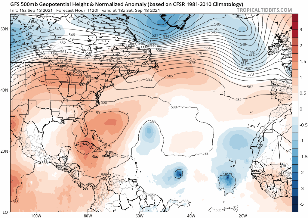
gatorcane wrote:Looks like nearly an identical 500MB setup for 95l as with Larry on this particular run of the long-range GFS with a one-two punch of troughs rolling off the eastern seaboard. Those troughs usher in well below normal temps for much of the eastern half of the CONUS:
https://i.postimg.cc/MpvPW5qw/gfs-z500a-Norm-atl-fh120-294.gif
Interesting, my local forecast (southern Wisconsin) has much ABOVE-normal temperatures from Thursday through the end of the period. 87 Sunday, 88 Monday.
0 likes
Re: ATL: INVEST 95L - Models
95L gets eaten by a stalling 96L on the 12z Euro.
Also, the 12z HWRF-P gets its focus stuck on a low pressure area over Africa, so we don’t know what the UL environment in the 12z HWRF is like. 95L’s more robust intensification phase suggests it might be closer to being under the anticyclone in this run.
Also, the 12z HWRF-P gets its focus stuck on a low pressure area over Africa, so we don’t know what the UL environment in the 12z HWRF is like. 95L’s more robust intensification phase suggests it might be closer to being under the anticyclone in this run.
0 likes
Irene '11 Sandy '12 Hermine '16 5/15/2018 Derecho Fay '20 Isaias '20 Elsa '21 Henri '21 Ida '21
I am only a meteorology enthusiast who knows a decent amount about tropical cyclones. Look to the professional mets, the NHC, or your local weather office for the best information.
I am only a meteorology enthusiast who knows a decent amount about tropical cyclones. Look to the professional mets, the NHC, or your local weather office for the best information.
Re: ATL: INVEST 95L - Models
12Z EPS at 240: amazingly quiet for Sep 24th, especially considering how active recent runs were

1 likes
Personal Forecast Disclaimer:
The posts in this forum are NOT official forecasts and should not be used as such. They are just the opinion of the poster and may or may not be backed by sound meteorological data. They are NOT endorsed by any professional institution or storm2k.org. For official information, please refer to the NHC and NWS products.
The posts in this forum are NOT official forecasts and should not be used as such. They are just the opinion of the poster and may or may not be backed by sound meteorological data. They are NOT endorsed by any professional institution or storm2k.org. For official information, please refer to the NHC and NWS products.
-
gatorcane
- S2K Supporter
- Posts: 23708
- Age: 48
- Joined: Sun Mar 13, 2005 3:54 pm
- Location: Boca Raton, FL
Re: ATL: INVEST 95L - Models
LarryWx wrote:12Z EPS at 240: amazingly quiet for Sep 24th, especially considering how active recent runs were
https://i.imgur.com/uuerAkO.png
Wow

It is apparent from the modeling there could be a rough road ahead for 95l
1 likes
-
otowntiger
- Category 5
- Posts: 1932
- Joined: Tue Aug 31, 2004 7:06 pm
Re: ATL: INVEST 95L - Models
. Apparently not just 95l. If the models are to be believed the rest of September could be anomolosly (sp) quiet.gatorcane wrote:LarryWx wrote:12Z EPS at 240: amazingly quiet for Sep 24th, especially considering how active recent runs were
https://i.imgur.com/uuerAkO.png
Wow
It is apparent from the modeling there could be a rough road ahead for 95l
0 likes
-
Category5Kaiju

- Category 5
- Posts: 4334
- Joined: Thu Dec 24, 2020 12:45 pm
- Location: Seattle and Phoenix
Re: ATL: INVEST 95L - Models
otowntiger wrote:. Apparently not just 95l. If the models are to be believed the rest of September could be anomolosly (sp) quiet.gatorcane wrote:LarryWx wrote:12Z EPS at 240: amazingly quiet for Sep 24th, especially considering how active recent runs were
https://i.imgur.com/uuerAkO.png
Wow
It is apparent from the modeling there could be a rough road ahead for 95l
Quite interestingly, the models are also pretty bearish about future activity in the WPAC and EPAC for most of this month...huh????
2 likes
Unless explicitly stated, all info in my posts is based on my own opinions and observations. Tropical storms and hurricanes can be extremely dangerous. Refer to an accredited weather research agency or meteorologist if you need to make serious decisions regarding an approaching storm.
-
jaxfladude
- Category 5
- Posts: 1249
- Joined: Wed Aug 24, 2005 9:36 pm
- Location: Jacksonville, Fla
Re: RE: Re: ATL: INVEST 95L - Models
Good news if true. Hopefully the 2021 Atlantic Hurricane Season ends soon enough!!!!otowntiger wrote:. Apparently not just 95l. If the models are to be believed the rest of September could be anomolosly (sp) quiet.gatorcane wrote:LarryWx wrote:12Z EPS at 240: amazingly quiet for Sep 24th, especially considering how active recent runs were
https://i.imgur.com/uuerAkO.png
Wow
It is apparent from the modeling there could be a rough road ahead for 95l
0 likes
Stay safe y'all
-
SouthFLTropics

- Category 5
- Posts: 4258
- Age: 50
- Joined: Thu Aug 14, 2003 8:04 am
- Location: Port St. Lucie, Florida
Re: ATL: INVEST 95L - Models
I’m just afraid that this is the calm before the storm… it may signal the shutdown to the MDR but I’m more concerned about what may come out of the Western Caribbean in October.
Sent from my iPhone using Tapatalk
Sent from my iPhone using Tapatalk
3 likes
Fourth Generation Florida Native
Personal Storm History: David 79, Andrew 92, Erin 95, Floyd 99, Irene 99, Frances 04, Jeanne 04, Wilma 05, Matthew 16, Irma 17, Ian 22, Nicole 22, Milton 24
Personal Storm History: David 79, Andrew 92, Erin 95, Floyd 99, Irene 99, Frances 04, Jeanne 04, Wilma 05, Matthew 16, Irma 17, Ian 22, Nicole 22, Milton 24
Re: ATL: INVEST 95L - Models
18z is a different run again. No 96l as it gets out quick. Ridge building in this time more.
Big variations in the mid range.
Edit: another low develops to dent the ridge. Also rapidly strengthening this time north of the islands. Crazy.
Big variations in the mid range.
Edit: another low develops to dent the ridge. Also rapidly strengthening this time north of the islands. Crazy.
0 likes
The following post is NOT an official forecast and should not be used as such. It is just the opinion of the poster and may or may not be backed by sound meteorological data. It is NOT endorsed by any professional institution including storm2k.org For Official Information please refer to the NHC and NWS products.
Who is online
Users browsing this forum: No registered users and 61 guests