
ATL: FRED - Models
Moderator: S2k Moderators
-
tolakram
- Admin

- Posts: 20186
- Age: 62
- Joined: Sun Aug 27, 2006 8:23 pm
- Location: Florence, KY (name is Mark)
Re: ATL: 94L - Models
GFS a bit further south this run so far.
0 likes
M a r k
- - - - -
Join us in chat: Storm2K Chatroom Invite. Android and IOS apps also available.
The posts in this forum are NOT official forecasts and should not be used as such. Posts are NOT endorsed by any professional institution or STORM2K.org. For official information and forecasts, please refer to NHC and NWS products.
-
tolakram
- Admin
- Posts: 20186
- Age: 62
- Joined: Sun Aug 27, 2006 8:23 pm
- Location: Florence, KY (name is Mark)
Re: ATL: 94L - Models
12Z GFS tracks over mostly land, but what's left looks to make it into the gulf.

0 likes
M a r k
- - - - -
Join us in chat: Storm2K Chatroom Invite. Android and IOS apps also available.
The posts in this forum are NOT official forecasts and should not be used as such. Posts are NOT endorsed by any professional institution or STORM2K.org. For official information and forecasts, please refer to NHC and NWS products.
- - - - -
Join us in chat: Storm2K Chatroom Invite. Android and IOS apps also available.
The posts in this forum are NOT official forecasts and should not be used as such. Posts are NOT endorsed by any professional institution or STORM2K.org. For official information and forecasts, please refer to NHC and NWS products.
-
tolakram
- Admin
- Posts: 20186
- Age: 62
- Joined: Sun Aug 27, 2006 8:23 pm
- Location: Florence, KY (name is Mark)
Re: ATL: 94L - Models

0 likes
M a r k
- - - - -
Join us in chat: Storm2K Chatroom Invite. Android and IOS apps also available.
The posts in this forum are NOT official forecasts and should not be used as such. Posts are NOT endorsed by any professional institution or STORM2K.org. For official information and forecasts, please refer to NHC and NWS products.
- - - - -
Join us in chat: Storm2K Chatroom Invite. Android and IOS apps also available.
The posts in this forum are NOT official forecasts and should not be used as such. Posts are NOT endorsed by any professional institution or STORM2K.org. For official information and forecasts, please refer to NHC and NWS products.
-
gatorcane

- S2K Supporter

- Posts: 23708
- Age: 48
- Joined: Sun Mar 13, 2005 3:54 pm
- Location: Boca Raton, FL
Re: ATL: 94L - Models
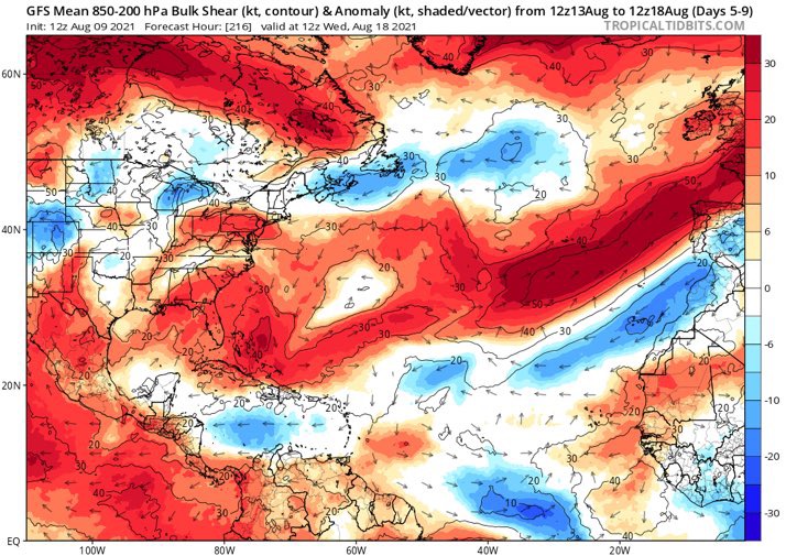
The GFS, as well as the other globals models show a hostile upper environment due to the ULL near Florida as 94l moves west through the Bahamas or Antilles. It does appear the upper environment becomes somewhat more favorable once 94l is past South Florida and in the EGOM on the GFS:

Last edited by gatorcane on Mon Aug 09, 2021 11:22 am, edited 1 time in total.
1 likes
-
tolakram
- Admin
- Posts: 20186
- Age: 62
- Joined: Sun Aug 27, 2006 8:23 pm
- Location: Florence, KY (name is Mark)
Re: ATL: 94L - Models
Weak and meandering onshore.

0 likes
M a r k
- - - - -
Join us in chat: Storm2K Chatroom Invite. Android and IOS apps also available.
The posts in this forum are NOT official forecasts and should not be used as such. Posts are NOT endorsed by any professional institution or STORM2K.org. For official information and forecasts, please refer to NHC and NWS products.
- - - - -
Join us in chat: Storm2K Chatroom Invite. Android and IOS apps also available.
The posts in this forum are NOT official forecasts and should not be used as such. Posts are NOT endorsed by any professional institution or STORM2K.org. For official information and forecasts, please refer to NHC and NWS products.
-
tolakram
- Admin
- Posts: 20186
- Age: 62
- Joined: Sun Aug 27, 2006 8:23 pm
- Location: Florence, KY (name is Mark)
Re: ATL: 94L - Models
gatorcane wrote:The GFS, as well as the other globals models show a hostile upper environment due to the ULL near Florida as 94l moves west through the Bahamas or Antilles. It does appear the upper environment becomes somewhat more favorable once 94l is past South Florida and in the EGOM on the GFS:
https://i.postimg.cc/bvH5V687/gfs-shear-watl-fh42-150.gif
Bastardi is pointing out the horrible track record models have when the MJO moves into phase II. I like his pattern matching so I'm paying attention. I still don't think this storm does much, but we'll see.
2 likes
M a r k
- - - - -
Join us in chat: Storm2K Chatroom Invite. Android and IOS apps also available.
The posts in this forum are NOT official forecasts and should not be used as such. Posts are NOT endorsed by any professional institution or STORM2K.org. For official information and forecasts, please refer to NHC and NWS products.
- - - - -
Join us in chat: Storm2K Chatroom Invite. Android and IOS apps also available.
The posts in this forum are NOT official forecasts and should not be used as such. Posts are NOT endorsed by any professional institution or STORM2K.org. For official information and forecasts, please refer to NHC and NWS products.
-
SFLcane

- S2K Supporter
- Posts: 10281
- Age: 48
- Joined: Sat Jun 05, 2010 1:44 pm
- Location: Lake Worth Florida
Re: ATL: 94L - Models
Based on some of the models it’s toast past 70w. Maybe a brief window to intensify a little bit.
0 likes
-
gatorcane
- S2K Supporter
- Posts: 23708
- Age: 48
- Joined: Sun Mar 13, 2005 3:54 pm
- Location: Boca Raton, FL
Re: ATL: 94L - Models
tolakram wrote:Southeast Florida is very difficult to hit (I know people think otherwise, but it's protected by the Islands). A track just north of the Hispaniola and a ridge in just the right place to stop a recurve, but weak enough to still send it NE is the equation needed. I don't think we'll know for sure until just a few days out. This is why everyone should already be prepared prior to the start of the season.
Agreed it is very difficult. I think Broward County, where Fort Lauderdale is located has never seen a major hurricane landfall from the east. South Florida is more vulnerable from hits from the south with storms recurving north than NE out of the Caribbean which makes lates season, particular October, South Florida’s most vulnerable month for a cyclone hit which many may not know either.
1 likes

Re: ATL: 94L - Models
0 likes
Personal Forecast Disclaimer:
The posts in this forum are NOT official forecast and should not be used as such. They are just the opinion of the poster and may or may not be backed by sound meteorological data. They are NOT endorsed by any professional institution or storm2k.org. For official information, please refer to the NHC and NWS products.
The posts in this forum are NOT official forecast and should not be used as such. They are just the opinion of the poster and may or may not be backed by sound meteorological data. They are NOT endorsed by any professional institution or storm2k.org. For official information, please refer to the NHC and NWS products.
-
tolakram
- Admin
- Posts: 20186
- Age: 62
- Joined: Sun Aug 27, 2006 8:23 pm
- Location: Florence, KY (name is Mark)
Re: ATL: 94L - Models
CMC keeps it north and while not strong, it's not torn apart like the GFS shows.

0 likes
M a r k
- - - - -
Join us in chat: Storm2K Chatroom Invite. Android and IOS apps also available.
The posts in this forum are NOT official forecasts and should not be used as such. Posts are NOT endorsed by any professional institution or STORM2K.org. For official information and forecasts, please refer to NHC and NWS products.
- - - - -
Join us in chat: Storm2K Chatroom Invite. Android and IOS apps also available.
The posts in this forum are NOT official forecasts and should not be used as such. Posts are NOT endorsed by any professional institution or STORM2K.org. For official information and forecasts, please refer to NHC and NWS products.
-
tolakram
- Admin
- Posts: 20186
- Age: 62
- Joined: Sun Aug 27, 2006 8:23 pm
- Location: Florence, KY (name is Mark)
Re: ATL: 94L - Models
CMC landfall, very close to the GFS.

0 likes
M a r k
- - - - -
Join us in chat: Storm2K Chatroom Invite. Android and IOS apps also available.
The posts in this forum are NOT official forecasts and should not be used as such. Posts are NOT endorsed by any professional institution or STORM2K.org. For official information and forecasts, please refer to NHC and NWS products.
- - - - -
Join us in chat: Storm2K Chatroom Invite. Android and IOS apps also available.
The posts in this forum are NOT official forecasts and should not be used as such. Posts are NOT endorsed by any professional institution or STORM2K.org. For official information and forecasts, please refer to NHC and NWS products.
-
AtlanticWind

- S2K Supporter
- Posts: 1898
- Age: 67
- Joined: Sun Aug 08, 2004 9:57 pm
- Location: Plantation,Fla
Re: ATL: 94L - Models
gatorcane wrote:tolakram wrote:Southeast Florida is very difficult to hit (I know people think otherwise, but it's protected by the Islands). A track just north of the Hispaniola and a ridge in just the right place to stop a recurve, but weak enough to still send it NE is the equation needed. I don't think we'll know for sure until just a few days out. This is why everyone should already be prepared prior to the start of the season.
Agreed it is very difficult. I think Broward County, where Fort Lauderdale is located has never seen a major hurricane landfall from the east. South Florida is more vulnerable from hits from the south with storms recurving north than NE out of the Caribbean which makes lates season, particular October, South Florida’s most vulnerable month for a cyclone hit which many may not know either.
1947 Cat 4 , Major Cape Verde storm hit Ft Lauderdale
0 likes
Re: ATL: 94L - Models
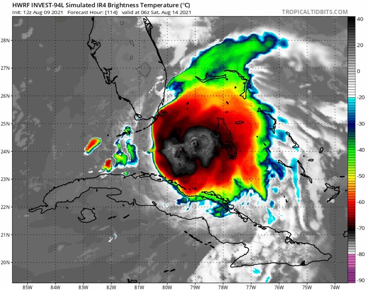
The 12z HWRF never really gets 94L going, even though it only barely clips the islands. The HMON isn't even coherent.
Last edited by BobHarlem on Mon Aug 09, 2021 12:49 pm, edited 1 time in total.
0 likes
-
jlauderdal
- S2K Supporter
- Posts: 7240
- Joined: Wed May 19, 2004 5:46 am
- Location: NE Fort Lauderdale
- Contact:
Re: ATL: 94L - Models
AtlanticWind wrote:gatorcane wrote:tolakram wrote:Southeast Florida is very difficult to hit (I know people think otherwise, but it's protected by the Islands). A track just north of the Hispaniola and a ridge in just the right place to stop a recurve, but weak enough to still send it NE is the equation needed. I don't think we'll know for sure until just a few days out. This is why everyone should already be prepared prior to the start of the season.
Agreed it is very difficult. I think Broward County, where Fort Lauderdale is located has never seen a major hurricane landfall from the east. South Florida is more vulnerable from hits from the south with storms recurving north than NE out of the Caribbean which makes lates season, particular October, South Florida’s most vulnerable month for a cyclone hit which many may not know either.
1947 Cat 4 , Major Cape Verde storm hit Ft Lauderdale
We get a bunch of majors hitting us on the model maps and majors heading right at us and getting close in the Bahamas only to never make it, the stars have to align to get a direct hit here.
1 likes
-
SFLcane
- S2K Supporter
- Posts: 10281
- Age: 48
- Joined: Sat Jun 05, 2010 1:44 pm
- Location: Lake Worth Florida
Re: ATL: 94L - Models
BobHarlem wrote:The 12z HWRF never really gets 94L going, even though it only barely clips the islands. The HMON isn't even coherent.
0 likes
-
SFLcane
- S2K Supporter
- Posts: 10281
- Age: 48
- Joined: Sat Jun 05, 2010 1:44 pm
- Location: Lake Worth Florida
Re: ATL: 94L - Models
jlauderdal wrote:AtlanticWind wrote:gatorcane wrote:
Agreed it is very difficult. I think Broward County, where Fort Lauderdale is located has never seen a major hurricane landfall from the east. South Florida is more vulnerable from hits from the south with storms recurving north than NE out of the Caribbean which makes lates season, particular October, South Florida’s most vulnerable month for a cyclone hit which many may not know either.
1947 Cat 4 , Major Cape Verde storm hit Ft Lauderdale
We get a bunch of majors hitting us on the model maps and majors heading right at us and getting close in the Bahamas only to never make it, the stars have to align to get a direct hit here.
Hits like those are extremely extremely rare coming from the Caribbean you have the islands protecting you and coming north of the islands the ridge has be in a perfect orientation to allow such path. Off course upper level conditions play a role which This go around are extremely hostile. Like I said past 70w this thing will struggle
1 likes
-
Hypercane_Kyle

- Category 5

- Posts: 3465
- Joined: Sat Mar 07, 2015 7:58 pm
- Location: Cape Canaveral, FL
Re: ATL: 94L - Models
12z HWRF keeps the system a tropical cyclone, but very weak. Getting absolutely slammed with shear in the Bahamas.
0 likes
My posts are my own personal opinion, defer to the National Hurricane Center (NHC) and other NOAA products for decision making during hurricane season.
-
Blown Away

- S2K Supporter
- Posts: 10253
- Joined: Wed May 26, 2004 6:17 am
Re: ATL: 94L - Models

12z EURO 48 Hours... Through PR and appears N of Hispaniola...
0 likes
Hurricane Eye Experience: David 79, Irene 99, Frances 04, Jeanne 04, Wilma 05… Hurricane Brush Experience: Andrew 92, Erin 95, Floyd 99, Matthew 16, Irma 17, Ian 22, Nicole 22…

Re: ATL: 94L - Models
12z HWRF has shifted further north, and 94L starts to re-develop near Florida after crossing over the DR. It also looks to begin recurving by 120hr.
0 likes
Irene '11 Sandy '12 Hermine '16 5/15/2018 Derecho Fay '20 Isaias '20 Elsa '21 Henri '21 Ida '21
I am only a meteorology enthusiast who knows a decent amount about tropical cyclones. Look to the professional mets, the NHC, or your local weather office for the best information.
I am only a meteorology enthusiast who knows a decent amount about tropical cyclones. Look to the professional mets, the NHC, or your local weather office for the best information.
Who is online
Users browsing this forum: No registered users and 16 guests