
WPAC: CHANTHU - Post-Tropical
Moderator: S2k Moderators
-
mrbagyo

- Category 5

- Posts: 3963
- Age: 33
- Joined: Thu Apr 12, 2012 9:18 am
- Location: 14.13N 120.98E
- Contact:
Re: WPAC: CHANTHU - Typhoon
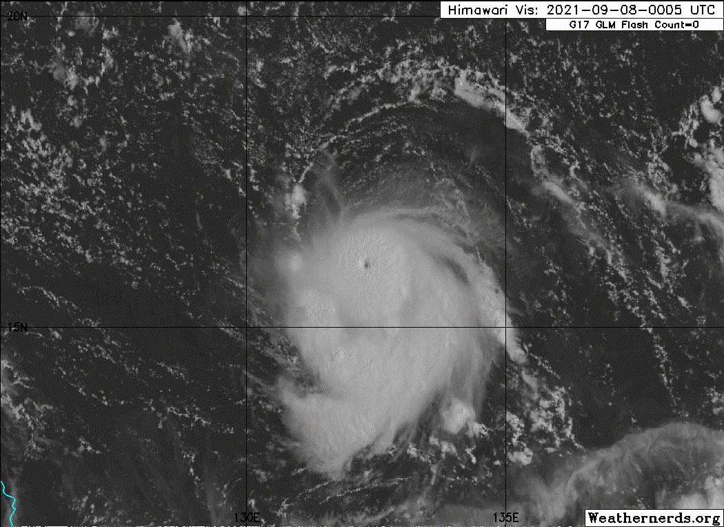
Eye has fully cleared, color of the ocean is now visible through that tiny eye
3 likes
The posts in this forum are NOT official forecast and should not be used as such. They are just the opinion of the poster and may or may not be backed by sound meteorological data. They are NOT endorsed by any professional institution or storm2k.org. For official information, please refer to RSMC, NHC and NWS products.

Re: WPAC: CHANTHU - Typhoon
2021SEP07 224000 5.4 958.0 99.6 5.4 5.7 5.7 NO LIMIT OFF OFF OFF OFF -11.08 -69.44 EYE 6 IR 41.2 16.04 -132.58 ARCHER HIM-8 21.0
2021SEP07 231000 5.4 957.9 99.6 5.3 4.8 3.9 0.5T/hour ON OFF OFF OFF -69.53 -60.32 UNIFRM N/A 41.2 16.29 -132.65 FCST HIM-8 21.2
2021SEP07 234000 5.4 957.9 99.6 5.3 4.8 3.2 1.2T/12hr ON OFF OFF OFF -69.94 -58.11 IRRCDO N/A 29.6 16.29 -132.58 FCST HIM-8 21.3
2021SEP08 001000 5.4 958.1 99.6 5.1 4.7 4.2 1.2T/12hr ON OFF OFF OFF -66.76 -64.93 UNIFRM N/A 29.6 15.69 -132.65 ARCHER HIM-8 20.6
1 likes
ヤンデレ女が寝取られるているのを見たい!!!
ECMWF ensemble NWPAC plots: https://ecmwfensnwpac.imgbb.com/
Multimodel NWPAC plots: https://multimodelnwpac.imgbb.com/
GFS Ensemble NWPAC plots (16 & 35 day forecast): https://gefsnwpac.imgbb.com/
Plots updated automatically
ECMWF ensemble NWPAC plots: https://ecmwfensnwpac.imgbb.com/
Multimodel NWPAC plots: https://multimodelnwpac.imgbb.com/
GFS Ensemble NWPAC plots (16 & 35 day forecast): https://gefsnwpac.imgbb.com/
Plots updated automatically

Re: WPAC: CHANTHU - Typhoon
This is probably 130 kt at a minimum and 145 kt at the maximum. The CDO is too ragged and not deep enough for me to think this is anything on the level of Wilma or Hagibis. Having recon data would help, but pinholes are so rare in the region where recon is readily available that there’s so little data to go off of as a comparison.
Using Delta as a comparison, I’m going to guess that Chanthu had a massive pressure drop around 11am-2pm EST, but the pressure leveled out from 2-6pm EST to let the winds catch up, like how Delta stair-stepped down to a pinhole Cat 4. This time frame was when the eye stopped warming. Once the winds caught up an hour or so ago, the storm began deepening again and the eye cleared, despite shear squashing the NW side.
Using Delta as a comparison, I’m going to guess that Chanthu had a massive pressure drop around 11am-2pm EST, but the pressure leveled out from 2-6pm EST to let the winds catch up, like how Delta stair-stepped down to a pinhole Cat 4. This time frame was when the eye stopped warming. Once the winds caught up an hour or so ago, the storm began deepening again and the eye cleared, despite shear squashing the NW side.
5 likes
Irene '11 Sandy '12 Hermine '16 5/15/2018 Derecho Fay '20 Isaias '20 Elsa '21 Henri '21 Ida '21
I am only a meteorology enthusiast who knows a decent amount about tropical cyclones. Look to the professional mets, the NHC, or your local weather office for the best information.
I am only a meteorology enthusiast who knows a decent amount about tropical cyclones. Look to the professional mets, the NHC, or your local weather office for the best information.
-
Yellow Evan

- Professional-Met

- Posts: 16240
- Age: 27
- Joined: Fri Jul 15, 2011 12:48 pm
- Location: Henderson, Nevada/Honolulu, HI
- Contact:

Re: WPAC: CHANTHU - Typhoon
163kt from CIRA’s experimental satellite estimates 
https://rammb-data.cira.colostate.edu/t ... 2109080000
https://rammb-data.cira.colostate.edu/t ... 2109080000
0 likes
Irene '11 Sandy '12 Hermine '16 5/15/2018 Derecho Fay '20 Isaias '20 Elsa '21 Henri '21 Ida '21
I am only a meteorology enthusiast who knows a decent amount about tropical cyclones. Look to the professional mets, the NHC, or your local weather office for the best information.
I am only a meteorology enthusiast who knows a decent amount about tropical cyclones. Look to the professional mets, the NHC, or your local weather office for the best information.
Re: WPAC: CHANTHU - Typhoon
aspen wrote:163kt from CIRA’s experimental satellite estimates
https://rammb-data.cira.colostate.edu/t ... 2109080000

We really need an smap reading
0 likes
ヤンデレ女が寝取られるているのを見たい!!!
ECMWF ensemble NWPAC plots: https://ecmwfensnwpac.imgbb.com/
Multimodel NWPAC plots: https://multimodelnwpac.imgbb.com/
GFS Ensemble NWPAC plots (16 & 35 day forecast): https://gefsnwpac.imgbb.com/
Plots updated automatically
ECMWF ensemble NWPAC plots: https://ecmwfensnwpac.imgbb.com/
Multimodel NWPAC plots: https://multimodelnwpac.imgbb.com/
GFS Ensemble NWPAC plots (16 & 35 day forecast): https://gefsnwpac.imgbb.com/
Plots updated automatically


Re: WPAC: CHANTHU - Typhoon
These storms that take the southwest dip usually go really big. I wouldn't doubt we have 140kts+ soon.
3 likes
The above post and any post by Ntxw is NOT an official forecast and should not be used as such. It is just the opinion of the poster and may or may not be backed by sound meteorological data. It is NOT endorsed by any professional institution including Storm2k. For official information, please refer to NWS products.
Help support Storm2K!

-
mrbagyo
- Category 5
- Posts: 3963
- Age: 33
- Joined: Thu Apr 12, 2012 9:18 am
- Location: 14.13N 120.98E
- Contact:
Re: WPAC: CHANTHU - Typhoon
Nepartak-ish


4 likes
The posts in this forum are NOT official forecast and should not be used as such. They are just the opinion of the poster and may or may not be backed by sound meteorological data. They are NOT endorsed by any professional institution or storm2k.org. For official information, please refer to RSMC, NHC and NWS products.
-
Sciencerocks
- Category 5
- Posts: 10186
- Age: 40
- Joined: Thu Jul 06, 2017 1:51 am
-
ElectricStorm

- Category 5
- Posts: 5147
- Age: 25
- Joined: Tue Aug 13, 2019 11:23 pm
- Location: Norman, OK
Re: WPAC: CHANTHU - Typhoon
I just cannot fathom how this could even possibly be only 120kts. Looks like a Cat 5 to me. 135kts at the very minimum
0 likes
B.S Meteorology, University of Oklahoma '25
Please refer to the NHC, NWS, or SPC for official information.
Please refer to the NHC, NWS, or SPC for official information.
-
Yellow Evan
- Professional-Met
- Posts: 16240
- Age: 27
- Joined: Fri Jul 15, 2011 12:48 pm
- Location: Henderson, Nevada/Honolulu, HI
- Contact:
Re: WPAC: CHANTHU - Typhoon
TPPN11 PGTW 080325
A. TYPHOON 19W (CHANTHU)
B. 08/0300Z
C. 15.81N
D. 131.77E
E. ONE/HMWRI8
F. T6.5/6.5/D3.0/24HRS STT: D0.5/03HRS
G. IR/EIR/VIS/MSI
H. REMARKS: 07A/PBO IRREG EYE/ANMTN. OW EYE SURROUNDED BY W
YIELDS AN E# OF 6.0. ADDED 0.5 EYE ADJUSTMENT FOR CMG, TO YIELD
A DT OF 6.5. MET YIELDS A 5.5 AND PT YIELDS A 6.0. DBO DT.
I. ADDITIONAL POSITIONS: NONE
BERMEA
Eye was WMG at 3z frame.
0 likes
-
ElectricStorm
- Category 5
- Posts: 5147
- Age: 25
- Joined: Tue Aug 13, 2019 11:23 pm
- Location: Norman, OK
Re: WPAC: CHANTHU - Typhoon
-80C tops expanding to the east and north a bit so the light shear from earlier might be lessening. Not like it had much effect on it anyway
0 likes
B.S Meteorology, University of Oklahoma '25
Please refer to the NHC, NWS, or SPC for official information.
Please refer to the NHC, NWS, or SPC for official information.
-
ElectricStorm
- Category 5
- Posts: 5147
- Age: 25
- Joined: Tue Aug 13, 2019 11:23 pm
- Location: Norman, OK
Re: WPAC: CHANTHU - Typhoon
Eye contracting a bit at the end of the loop. One of the smallest eyes I've ever seen. Amazing storm

2 likes
B.S Meteorology, University of Oklahoma '25
Please refer to the NHC, NWS, or SPC for official information.
Please refer to the NHC, NWS, or SPC for official information.
-
dexterlabio
- Category 5
- Posts: 3508
- Joined: Sat Oct 24, 2009 11:50 pm
Re: WPAC: CHANTHU - Typhoon
I believe the SW dive cannot be attributed to fujiwara interaction with Conson, but rather the strength of the subtropical ridge to its north. Intense typhoons diving SW is a classic sight during La Niña years.
0 likes
Personal Forecast Disclaimer:
The posts in this forum are NOT official forecast and should not be used as such. They are just the opinion of the poster and may or may not be backed by sound meteorological data. They are NOT endorsed by any professional institution or storm2k.org. For official information, please refer to the NHC and NWS products.
The posts in this forum are NOT official forecast and should not be used as such. They are just the opinion of the poster and may or may not be backed by sound meteorological data. They are NOT endorsed by any professional institution or storm2k.org. For official information, please refer to the NHC and NWS products.
-
mrbagyo
- Category 5
- Posts: 3963
- Age: 33
- Joined: Thu Apr 12, 2012 9:18 am
- Location: 14.13N 120.98E
- Contact:
Re: WPAC: CHANTHU - Typhoon
00z GFS dips it further south and west - now showing a potential landfall in extreme northern tip of Luzon
0 likes
The posts in this forum are NOT official forecast and should not be used as such. They are just the opinion of the poster and may or may not be backed by sound meteorological data. They are NOT endorsed by any professional institution or storm2k.org. For official information, please refer to RSMC, NHC and NWS products.
-
Ed_2001

- Tropical Storm

- Posts: 246
- Age: 24
- Joined: Wed Jun 21, 2017 11:39 pm
- Location: Santa Barbara, CA>>Tampa, FL
Re: WPAC: CHANTHU - Typhoon
Eye has cooled back down and cdo looks to be expanding. EWRC coming soon?
0 likes
The answer my friend, is blowing in the wind...
-
Stormybajan

- Category 1

- Posts: 453
- Joined: Thu May 20, 2021 3:21 pm
- Location: Windward Islands
Re: WPAC: CHANTHU - Typhoon
IMO Chanthu is one of the rare typhoons/hurricanes that look better on IR than on visible. Very unique look, I hope one a picture of Chanthu is placed in the Best Sat Photos of Alltime thread ..if its not Cat 5 intensity then its very close at around 130-135 knots.
0 likes
Sad West Indies and Manchester United fan ⚽️
-
ElectricStorm
- Category 5
- Posts: 5147
- Age: 25
- Joined: Tue Aug 13, 2019 11:23 pm
- Location: Norman, OK
Re: WPAC: CHANTHU - Typhoon
Eye is extremely small now and there appears to be a moat on IR so it looks to me like an ERC is about to happen, but we'll need a microwave pass to confirm. I personally would say it peaked at ~140kts a couple hours ago. It should have time to intensify again after the ERC.
Also that's quite the SW dive there, northern Luzon might be in play
Also that's quite the SW dive there, northern Luzon might be in play
0 likes
B.S Meteorology, University of Oklahoma '25
Please refer to the NHC, NWS, or SPC for official information.
Please refer to the NHC, NWS, or SPC for official information.
-
mrbagyo
- Category 5
- Posts: 3963
- Age: 33
- Joined: Thu Apr 12, 2012 9:18 am
- Location: 14.13N 120.98E
- Contact:
Re: WPAC: CHANTHU - Typhoon
Weather Dude wrote:Eye is extremely small now and there appears to be a moat on IR so it looks to me like an ERC is about to happen, but we'll need a microwave pass to confirm. I personally would say it peaked at ~140kts a couple hours ago. It should have time to intensify again after the ERC.
Also that's quite the SW dive there, northern Luzon might be in play
latest microwave pass (& there would be 2 more pass later- 0732 & 0746z)


0 likes
The posts in this forum are NOT official forecast and should not be used as such. They are just the opinion of the poster and may or may not be backed by sound meteorological data. They are NOT endorsed by any professional institution or storm2k.org. For official information, please refer to RSMC, NHC and NWS products.

Who is online
Users browsing this forum: No registered users and 39 guests