ATL: ELSA - Post-Tropical - Discussion

Moderator: S2k Moderators

Message
Author
User avatar
aspen
Category 5
Category 5
Posts: 8819
Joined: Sat Oct 12, 2019 7:10 pm
Location: Connecticut, USA

Re: ATL: ELSA - Hurricane - Discussion

#1521 Postby aspen » Fri Jul 02, 2021 3:45 pm

Ubuntwo wrote:
Blown Away wrote:An hour ago Elsa was at 13.99N and she is steady climbing. NHC at 11am forecasted Elsa to cross 14.6N later tonight, IMO Elsa will cross that mark very soon.

Looks to be at about 14.1N based on radar edge returns.

Exactly where the 12z HWRF predicted it was going to be at this time.
1 likes   
Irene '11 Sandy '12 Hermine '16 5/15/2018 Derecho Fay '20 Isaias '20 Elsa '21 Henri '21 Ida '21

I am only a meteorology enthusiast who knows a decent amount about tropical cyclones. Look to the professional mets, the NHC, or your local weather office for the best information.

User avatar
GCANE
S2K Supporter
S2K Supporter
Posts: 11500
Joined: Mon Oct 22, 2007 8:03 am

Re: ATL: ELSA - Hurricane - Discussion

#1522 Postby GCANE » Fri Jul 02, 2021 3:46 pm

Deepest convection right on the CoC.
Elsa is getting serious.

Image
3 likes   

User avatar
toad strangler
S2K Supporter
S2K Supporter
Posts: 4543
Joined: Sun Jul 28, 2013 3:09 pm
Location: Earth
Contact:

Re: ATL: ELSA - Hurricane - Discussion

#1523 Postby toad strangler » Fri Jul 02, 2021 3:46 pm

Main thing I'm going to be looking at intently is the growing thought that Elsa will approach Cuba at such an angle that the center could have to traverse much terra firma before she pops out on the N side. Worst case would be almost due S to N has Cuba would pretty much be just a speed bump but come in at the angle I'm seeing and Cuba knocks her teeth out.
Last edited by toad strangler on Fri Jul 02, 2021 3:48 pm, edited 2 times in total.
1 likes   

User avatar
captainbarbossa19
Professional-Met
Professional-Met
Posts: 1092
Age: 27
Joined: Wed Aug 21, 2019 11:09 pm
Location: Beaumont, TX

Re: ATL: ELSA - Hurricane - Discussion

#1524 Postby captainbarbossa19 » Fri Jul 02, 2021 3:47 pm

Not sure if it's what I am seeing, but on visible, it sure looks like an eye feature is trying to develop.
0 likes   

User avatar
InfernoFlameCat
Category 5
Category 5
Posts: 2102
Age: 22
Joined: Mon Dec 14, 2020 10:52 am
Location: Buford, GA

Re: ATL: ELSA - Hurricane - Discussion

#1525 Postby InfernoFlameCat » Fri Jul 02, 2021 3:49 pm

Yeah I saw that too and mentioned it. Glad to see I am not the only one.
0 likes   
I am by no means a professional. DO NOT look at my forecasts for official information or make decisions based on what I post.

Goal: to become a registered expert over tropical and subtropical cyclones.

User avatar
NDG
S2K Supporter
S2K Supporter
Posts: 15446
Joined: Sun Jul 09, 2006 10:14 pm
Location: Orlando, FL

Re: ATL: ELSA - Hurricane - Discussion

#1526 Postby NDG » Fri Jul 02, 2021 3:55 pm

5:00 PM AST Fri Jul 2
Location: 14.2°N 63.7°W
Moving: W at 30 mph
Min pressure: 991 mb
Max sustained: 85 mph
0 likes   

User avatar
toad strangler
S2K Supporter
S2K Supporter
Posts: 4543
Joined: Sun Jul 28, 2013 3:09 pm
Location: Earth
Contact:

Re: ATL: ELSA - Hurricane - Discussion

#1527 Postby toad strangler » Fri Jul 02, 2021 3:55 pm

Hurricane Elsa
5:00 PM AST Fri Jul 2
Location: 14.2°N 63.7°W
Moving: W at 30 mph
Min pressure: 991 mb
Max sustained: 85 mph


JESUS 30mph :P
1 likes   

User avatar
gatorcane
S2K Supporter
S2K Supporter
Posts: 23691
Age: 47
Joined: Sun Mar 13, 2005 3:54 pm
Location: Boca Raton, FL

Re: ATL: ELSA - Hurricane - Discussion

#1528 Postby gatorcane » Fri Jul 02, 2021 3:55 pm

Image
0 likes   

User avatar
aspen
Category 5
Category 5
Posts: 8819
Joined: Sat Oct 12, 2019 7:10 pm
Location: Connecticut, USA

Re: ATL: ELSA - Hurricane - Discussion

#1529 Postby aspen » Fri Jul 02, 2021 3:56 pm

GCANE wrote:Deepest convection right on the CoC.
Elsa is getting serious.

https://i.imgur.com/fqvuAid.jpg

I think the CoC is a little over to the left, not perfectly under that blob.

The 5pm NHC forecast is, once again, conservative with intensity and doesn’t show any more intensification. A fair assessment because crashing into Haiti is still not off the table yet.
2 likes   
Irene '11 Sandy '12 Hermine '16 5/15/2018 Derecho Fay '20 Isaias '20 Elsa '21 Henri '21 Ida '21

I am only a meteorology enthusiast who knows a decent amount about tropical cyclones. Look to the professional mets, the NHC, or your local weather office for the best information.

User avatar
GCANE
S2K Supporter
S2K Supporter
Posts: 11500
Joined: Mon Oct 22, 2007 8:03 am

Re: ATL: ELSA - Hurricane - Discussion

#1530 Postby GCANE » Fri Jul 02, 2021 3:56 pm

Picking up some moisture from the Amazon

Image
3 likes   

User avatar
eastcoastFL
Category 5
Category 5
Posts: 3901
Age: 43
Joined: Thu Apr 12, 2007 12:29 pm
Location: Palm City, FL

Re: ATL: ELSA - Hurricane - Discussion

#1531 Postby eastcoastFL » Fri Jul 02, 2021 3:57 pm

Image
1 likes   
Personal Forecast Disclaimer:
The posts in this forum are NOT official forecast and should not be used as such. They are just the opinion of the poster and may or may not be backed by sound meteorological data. They are NOT endorsed by any professional institution or storm2k.org. For official information, please refer to the NHC and NWS products.

User avatar
aspen
Category 5
Category 5
Posts: 8819
Joined: Sat Oct 12, 2019 7:10 pm
Location: Connecticut, USA

Re: ATL: ELSA - Hurricane - Discussion

#1532 Postby aspen » Fri Jul 02, 2021 3:57 pm


It really slows down starting late tomorrow. If it stays off of the Haitian/Jamaican/Cuban coasts, things could get nasty.
0 likes   
Irene '11 Sandy '12 Hermine '16 5/15/2018 Derecho Fay '20 Isaias '20 Elsa '21 Henri '21 Ida '21

I am only a meteorology enthusiast who knows a decent amount about tropical cyclones. Look to the professional mets, the NHC, or your local weather office for the best information.

User avatar
toad strangler
S2K Supporter
S2K Supporter
Posts: 4543
Joined: Sun Jul 28, 2013 3:09 pm
Location: Earth
Contact:

Re: ATL: ELSA - Hurricane - Discussion

#1533 Postby toad strangler » Fri Jul 02, 2021 3:59 pm

aspen wrote:

It really slows down starting late tomorrow. If it stays off of the Haitian/Jamaican/Cuban coasts, things could get nasty.


If I was forced to, I would hang my hat on Cuba knocking her teeth out due to angle of approach. I do know that, nothing is off the table .... of course.
0 likes   

tolakram
Admin
Admin
Posts: 20012
Age: 62
Joined: Sun Aug 27, 2006 8:23 pm
Location: Florence, KY (name is Mark)

Re: ATL: ELSA - Hurricane - Discussion

#1534 Postby tolakram » Fri Jul 02, 2021 4:00 pm

Hurricane Elsa Discussion Number 10
NWS National Hurricane Center Miami FL AL052021
500 PM AST Fri Jul 02 2021

Reports from a NOAA Hurricane Hunter aircraft indicate that Elsa
has strengthened a little more since the last advisory, with a
combination of flight-level winds, SFMR surface wind estimates, and
dropsonde data showing that the maximum winds are near 75 kt. The
aircraft also reported that the 700-mb circulation remains somewhat
disorganized, and that the 700-mb center is not vertically aligned
with with the surface center. The former issue is likely due to
the rapid motion, and the latter may be due to the effects of
westerly shear.

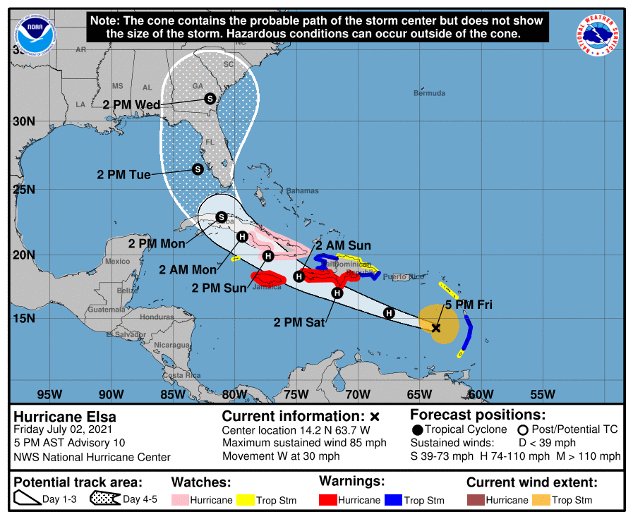
The initial motion now is 290/26. There is again little change to
the forecast track or the forecast guidance. The guidance is in
good agreement on a rapid west-northwestward notion to near the
south coast of the Dominican Republic and Haiti by 24-30 h, followed
by a continued west-northwestward motion at a slower forward speed
through 48 h. After that time, Elsa should gradually turn
northwestward and eventually northward as it moves through a
weakness in the subtropical ridge created by a mid-latitude trough
over the eastern United States. This motion should take the
cyclone across Cuba and over the eastern Gulf of Mexico or the
nearby Florida Peninsula, eventually moving into the southeastern
United States by the end of the period. The track guidance is a
little less divergent than earlier, but there is still enough spread
in the potential tracks that this part of the forecast remains low
confidence.

The latest global model runs and the associated intensity guidance
are forecasting a less favorable environment for Elsa during the
next several days. The SHIPS model now calls for 10-20 kt of
northwesterly shear during the next 48 h, and 15-25 kt of shear
after 60 h. In addition, the 12Z GFS forecasts a considerably
weaker storm than its last several runs. The intensity forecast
thus calls for little change in strength during the first 24 h,
although it is possible the hurricane could strengthen a little more
during that time. After that, land interaction and shear are
likely to cause weakening until Elsa emerges into the Gulf of
Mexico. However, the HWRF still calls for Elsa to intensify into a
Category 3 hurricane, and like the track forecast the intensity
forecast remains of low confidence due to the spread in the
guidance.

It should be noted that the average NHC track errors are 175 miles
and 200 miles at days 4 and 5, respectively. Given the
larger-than-normal uncertainty and because hazards will extend well
away from the center of the storm, users are urged to not focus on
the exact forecast points.

Key Messages:

1. Hurricane conditions and dangerous storm surge are expected
within the Hurricane Warning areas in Haiti and the Dominican
Republic beginning Saturday and in Jamaica beginning Sunday.

2. Heavy rainfall will gradually subside across the Windward and
southern Leeward Islands tonight, including Barbados. Outer rain
bands will impact Puerto Rico by late tonight, and affect southern
Hispaniola and Jamaica Saturday into Sunday. Isolated to scattered
flash flooding and mudslides are possible. By early next week, heavy
rain will impact the Cayman Islands and Cuba. Significant flooding
and mudslides are possible.

3. Hurricane conditions and dangerous storm surge are possible in
portions of eastern Cuba beginning early Sunday where a Hurricane
Watch is in effect. There is an increasing risk of wind, storm
surge, and rainfall impacts elsewhere in Cuba Sunday and Monday.

4. There is an increasing risk of storm surge, wind, and rainfall
impacts beginning Monday in the Florida Keys and spreading northward
along the Florida Peninsula through Tuesday. However, the forecast
uncertainty remains larger than usual due to Elsa's potential
interaction with the islands of Hispaniola and Cuba this weekend.
Interests throughout Florida should monitor Elsa's progress and
updates to the forecast.

FORECAST POSITIONS AND MAX WINDS

INIT 02/2100Z 14.2N 63.7W 75 KT 85 MPH
12H 03/0600Z 15.4N 67.5W 75 KT 85 MPH
24H 03/1800Z 17.0N 71.7W 75 KT 85 MPH
36H 04/0600Z 18.3N 74.8W 70 KT 80 MPH
48H 04/1800Z 19.9N 77.3W 70 KT 80 MPH...INLAND
60H 05/0600Z 21.4N 79.4W 65 KT 75 MPH...OVER WATER
72H 05/1800Z 22.9N 81.1W 55 KT 65 MPH...INLAND
96H 06/1800Z 26.5N 83.0W 55 KT 65 MPH...OVER WATER
120H 07/1800Z 31.6N 82.0W 40 KT 45 MPH...INLAND

$$
Forecaster Beven
0 likes   
M a r k
- - - - -
Join us in chat: Storm2K Chatroom Invite. Android and IOS apps also available.

The posts in this forum are NOT official forecasts and should not be used as such. Posts are NOT endorsed by any professional institution or STORM2K.org. For official information and forecasts, please refer to NHC and NWS products.

psyclone
S2K Supporter
S2K Supporter
Posts: 4769
Joined: Wed Aug 24, 2005 9:04 pm
Location: palm harbor fl

Re: ATL: ELSA - Hurricane - Discussion

#1535 Postby psyclone » Fri Jul 02, 2021 4:01 pm

It's another track where the black line is within stone throwing distance. now just barely to my west after being slightly to my east the past two advisories.
0 likes   

AutoPenalti
Category 5
Category 5
Posts: 4030
Age: 29
Joined: Mon Aug 17, 2015 4:16 pm
Location: Ft. Lauderdale, Florida

Re: ATL: ELSA - Hurricane - Discussion

#1536 Postby AutoPenalti » Fri Jul 02, 2021 4:04 pm

Didn’t take into account SHIPS was forecasting shear in the GoM
0 likes   
The posts in this forum are NOT official forecasts and should not be used as such. They are just the opinion of the poster and may or may not be backed by sound meteorological data. They are NOT endorsed by any professional institution or STORM2K. For official information, please refer to products from the NHC and NWS.


Model Runs Cheat Sheet:
GFS (5:30 AM/PM, 11:30 AM/PM)
HWRF, GFDL, UKMET, NAVGEM (6:30-8:00 AM/PM, 12:30-2:00 AM/PM)
ECMWF (1:45 AM/PM)

TCVN
is a weighted averaged

User avatar
GCANE
S2K Supporter
S2K Supporter
Posts: 11500
Joined: Mon Oct 22, 2007 8:03 am

Re: ATL: ELSA - Hurricane - Discussion

#1537 Postby GCANE » Fri Jul 02, 2021 4:05 pm

For a 2C warm core, can't get much better looking than this.
Tracking into some heavy duty CAPE and low 355K PV.
NW side of the CoC is pretty low shear thru 250mb.

Image
1 likes   

User avatar
Hurrilurker
Category 2
Category 2
Posts: 719
Joined: Mon Jun 09, 2003 3:32 pm
Location: San Francisco, CA

Re: ATL: ELSA - Hurricane - Discussion

#1538 Postby Hurrilurker » Fri Jul 02, 2021 4:09 pm

NHC still saying this is the max intensity for the life of the storm. We'll see but the initial value keeps getting bumped up.
0 likes   

User avatar
aspen
Category 5
Category 5
Posts: 8819
Joined: Sat Oct 12, 2019 7:10 pm
Location: Connecticut, USA

Re: ATL: ELSA - Hurricane - Discussion

#1539 Postby aspen » Fri Jul 02, 2021 4:12 pm

tolakram wrote:
The latest global model runs and the associated intensity guidance
are forecasting a less favorable environment for Elsa during the
next several days. The SHIPS model now calls for 10-20 kt of
northwesterly shear during the next 48 h, and 15-25 kt of shear
after 60 h. In addition, the 12Z GFS forecasts a considerably
weaker storm than its last several runs. The intensity forecast
thus calls for little change in strength during the first 24 h,
although it is possible the hurricane could strengthen a little more
during that time. After that, land interaction and shear are
likely to cause weakening until Elsa emerges into the Gulf of
Mexico. However, the HWRF still calls for Elsa to intensify into a
Category 3 hurricane, and like the track forecast the intensity
forecast remains of low confidence due to the spread in the
guidance.


Huh, moderate shear now forecast by SHIPS for the next 2-3 days. I wonder if the 18z HWRF will take that into account, and how much its forecast might change.

It certainly isn’t nearly enough to weaken Elsa into an open wave like some models suggest.
0 likes   
Irene '11 Sandy '12 Hermine '16 5/15/2018 Derecho Fay '20 Isaias '20 Elsa '21 Henri '21 Ida '21

I am only a meteorology enthusiast who knows a decent amount about tropical cyclones. Look to the professional mets, the NHC, or your local weather office for the best information.

AveryTheComrade
Tropical Depression
Tropical Depression
Posts: 76
Joined: Fri Jul 10, 2020 9:19 pm

Re: ATL: ELSA - Hurricane - Discussion

#1540 Postby AveryTheComrade » Fri Jul 02, 2021 4:17 pm

Ok definite turn the to the west lately, maybe ruling out the Hispaniola path
0 likes   


Return to “2021”

Who is online

Users browsing this forum: No registered users and 8 guests