EPAC: CARLOS - Remnants

Moderator: S2k Moderators

Message
Author
User avatar
cycloneye
Admin
Admin
Posts: 139339
Age: 67
Joined: Thu Oct 10, 2002 10:54 am
Location: San Juan, Puerto Rico

Re: EPAC: CARLOS - Tropical Storm

#161 Postby cycloneye » Sat Jun 12, 2021 9:54 pm

...TROPICAL DEPRESSION INTENSIFIES INTO TROPICAL STORM CARLOS...


SUMMARY OF 800 PM PDT...0300 UTC...INFORMATION
----------------------------------------------
LOCATION...11.9N 124.5W
ABOUT 1225 MI...1970 KM SW OF THE SOUTHERN TIP OF BAJA CALIFORNIA
MAXIMUM SUSTAINED WINDS...40 MPH...65 KM/H
PRESENT MOVEMENT...W OR 270 DEGREES AT 7 MPH...11 KM/H
MINIMUM CENTRAL PRESSURE...1005 MB...29.68 INCHES


Tropical Storm Carlos Discussion Number 2
NWS National Hurricane Center Miami FL EP032021
800 PM PDT Sat Jun 12 2021

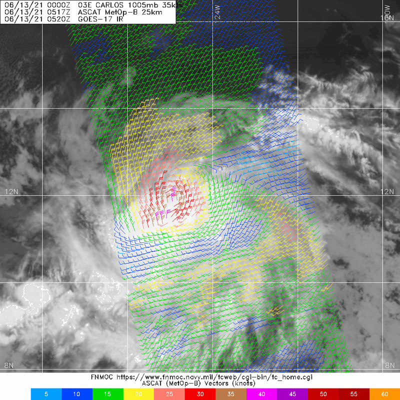
Satellite imagery indicates improved organization this evening as a
cold convective burst has expanded over the estimated low-level
circulation center. A 2032 UTC AMSR2 microwave pass indicated that
underneath this convective burst was also improved convective
banding, especially over the southern semicircle. The latest round
of Dvorak satellite estimates were T2.0/30 kt from TAFB and T2.5/35
kt from SAB. The most recent UW-CIMSS Advanced Dvorak Technique
value was also T2.5/35 kt. Favoring the higher intensity estimates,
and assuming some intensification has occurred from the earlier
scatterometer passes, Tropical Depression Three-E has been upgraded
to Tropical Storm Carlos with an advisory intensity of 35 kt.

Carlos appears to be gradually turning leftward and slowing down
this evening, with the most recent estimated motion at 270/06 kt.
The mid-level ridge north of Carlos is forecast to gradually weaken,
shift northward, and then be replaced by a deep-layer trough that
will essentially shut down the steering currents near the cyclone
after 24 h. Between 36 to 48 h the motion of Carlos is likely to
slow to a crawl, generally to the west-southwest. By 72 h, another
mid-to-upper level trough digging in from the northwest will finally
induce some northerly steering, helping Carlos to gradually
accelerate to the north. The latest track forecast is a bit west of
the previous NHC forecast owing to the current motion, but remains
very close to the HFIP corrected consensus and TCVE track consensus.
It should be noted that there remains large spread in the guidance
on how quickly Carlos slows down, with the latest GFS forecast
slowing down the cyclone almost immediately, while the CMC and ECMWF
runs show a much faster track to the west-southwest.

The intensity forecast is tricky due to both the small size of the
tropical cyclone and also the less than optimal environment
surrounding the system. While deep-layer vertical wind shear is only
expected to be low to moderate over the next 72 h, mid-level shear
out of the north to northwest is a bit higher (15-25 kt) and could
occasionally import very dry mid-level air from that direction. In
fact, ECMWF-SHIPS mid-level humidity values gradually decrease to
under 500ver the next 36 h. In addition, the very slow motion of
Carlos expected between 24-72 h could potentially upwell cooler
sea-surface temperatures than the current 27-28 C values along the
forecast track. For this reason, the latest NHC intensity forecast
is fairly conservative, forecasting a peak intensity of 45 kt
between 24-60 h, which is close to the HFIP corrected consensus and
peak intensity of the most recent HWRF run. Thereafter, as the storm
begins to gain latitude, increasingly dry, stable air in addition to
decreasing sea surface temperatures should lead to gradual weakening
beyond 60 h.


FORECAST POSITIONS AND MAX WINDS

INIT 13/0300Z 11.9N 124.5W 35 KT 40 MPH
12H 13/1200Z 11.8N 125.5W 40 KT 45 MPH
24H 14/0000Z 11.4N 126.5W 45 KT 50 MPH
36H 14/1200Z 10.8N 127.2W 45 KT 50 MPH
48H 15/0000Z 10.6N 127.4W 45 KT 50 MPH
60H 15/1200Z 10.3N 127.7W 45 KT 50 MPH
72H 16/0000Z 10.3N 128.0W 40 KT 45 MPH
96H 17/0000Z 11.5N 128.1W 35 KT 40 MPH
120H 18/0000Z 13.5N 127.9W 30 KT 35 MPH

$$
Forecaster Papin/Pasch
0 likes   
Visit the Caribbean-Central America Weather Thread where you can find at first post web cams,radars
and observations from Caribbean basin members Click Here

User avatar
AnnularCane
S2K Supporter
S2K Supporter
Posts: 2647
Joined: Thu Jun 08, 2006 9:18 am
Location: Wytheville, VA

Re: EPAC: CARLOS - Tropical Storm

#162 Postby AnnularCane » Sat Jun 12, 2021 10:05 pm

Bienvenidos, Carlos! :Bcool:
2 likes   
"But it never rained rain. It never snowed snow. And it never blew just wind. It rained things like soup and juice. It snowed mashed potatoes and green peas. And sometimes the wind blew in storms of hamburgers." -- Judi Barrett, Cloudy with a Chance of Meatballs

User avatar
Kingarabian
S2K Supporter
S2K Supporter
Posts: 15451
Joined: Sat Aug 08, 2009 3:06 am
Location: Honolulu, Hawaii

Re: EPAC: CARLOS - Tropical Storm

#163 Postby Kingarabian » Sun Jun 13, 2021 1:04 am

Image
Some 40kt vectors. Could be 45kts now.
0 likes   
RIP Kobe Bryant

User avatar
Kingarabian
S2K Supporter
S2K Supporter
Posts: 15451
Joined: Sat Aug 08, 2009 3:06 am
Location: Honolulu, Hawaii

Re: EPAC: CARLOS - Tropical Storm

#164 Postby Kingarabian » Sun Jun 13, 2021 1:28 am

CMC and Euro have had their strengths so far but remain garbage in initializing TC's correctly.

Image
Image
0 likes   
RIP Kobe Bryant

Sciencerocks
Category 5
Category 5
Posts: 7287
Age: 38
Joined: Thu Jul 06, 2017 1:51 am

Re: EPAC: CARLOS - Tropical Storm

#165 Postby Sciencerocks » Sun Jun 13, 2021 2:16 am

Image
1 likes   

storminabox
Category 1
Category 1
Posts: 260
Joined: Sun Jul 09, 2017 10:50 pm

Re: EPAC: CARLOS - Tropical Storm

#166 Postby storminabox » Sun Jun 13, 2021 3:49 am

A solid tropical storm. Glad this guy could come back and make a name for itself.
0 likes   

User avatar
Kingarabian
S2K Supporter
S2K Supporter
Posts: 15451
Joined: Sat Aug 08, 2009 3:06 am
Location: Honolulu, Hawaii

Re: EPAC: CARLOS - Tropical Storm

#167 Postby Kingarabian » Sun Jun 13, 2021 3:59 am

UW - CIMSS
ADVANCED DVORAK TECHNIQUE
ADT-Version 9.0
Tropical Cyclone Intensity Algorithm

----- Current Analysis -----
Date : 13 JUN 2021 Time : 082032 UTC
Lat : 11:51:38 N Lon : 125:04:14 W


CI# /Pressure/ Vmax
3.0 /1003.6mb/ 45.0kt


Final T# Adj T# Raw T#
3.0 3.2 3.2

Center Temp : -61.8C Cloud Region Temp : -56.7C

Scene Type : UNIFORM CDO CLOUD REGION

Subtropical Adjustment : OFF

Extratropical Adjustment : OFF

Positioning Method : FORECAST INTERPOLATION

Ocean Basin : EAST PACIFIC
Dvorak CI > MSLP Conversion Used : CKZ Method

Tno/CI Rules : Constraint Limits : NO LIMIT
Weakening Flag : OFF
Rapid Dissipation Flag : OFF
0 likes   
RIP Kobe Bryant

User avatar
Kingarabian
S2K Supporter
S2K Supporter
Posts: 15451
Joined: Sat Aug 08, 2009 3:06 am
Location: Honolulu, Hawaii

Re: EPAC: CARLOS - Tropical Storm

#168 Postby Kingarabian » Sun Jun 13, 2021 4:11 am

Tropical Storm Carlos Discussion Number 3
NWS National Hurricane Center Miami FL EP032021
200 AM PDT Sun Jun 13 2021

Infrared and scatterometer satellite data indicate that Carlos
remains a compact tropical cyclone. Two ASCAT passes between
0400-0500 UTC revealed a radius of maximum wind of 10-12 nmi and
tropical-storm-force winds that only extended outward about 20 nmi.
Cloud tops colder than -50C only extend outward about 60 nmi from
the center. The earlier ASCAT-A/-B passes contained peak surface
wind vectors of 37 kt/40 kt, respectively, so the estimated
intensity has been increased to 40 kt for this advisory, which
could be a little conservative owing to the small size of the
cyclone and possible undersampling of the scatterometer instrument.

The initial motion estimate is due west or 270/07 kt. There is
little change to the previous NHC track forecast or reasoning. The
latest model runs are in good agreement on Carlos turning toward the
west-southwest later today, followed by a southwestward motion on
Monday and Tuesday as a low- to mid-level ridge to the north of the
cyclone builds southward. By day 3, the models diverge significantly
when the deep-layer steering currents collapse, followed by possible
rapid weakening. The ECMWF weakens Carlos into a shallow remnant low
by 72 h, with the shallow vortex then being driven southwestward by
a strong low-level ridge to the north and northeast. In contrast,
the GFS and some of the other global and regional models keep Carlos
stronger and vertically deeper, which results in a ridge to the east
lifting the cyclone out toward the north. Given the large spread in
the track guidance on days 4 and 5, the new NHC track forecast is
similar to but slightly slower than the previous advisory track, and
close to a blend of the TVCE and GFEX simple consensus track models.

Carlos' small size in combination with the relatively low deep-layer
vertical shear of 5-10 kt for the next 36 h or so would normally
argue for significant strengthening. However, the cyclone's
proximity to very dry mid-level and cooler sea-surface just to its
north and northwest is expected to result in the periodic
entrainment of stable air for the 72 h or so, resulting in
intermittent disruptions of the central deep convection. Thus,
little change in strength is forecast during that time. Thereafter,
the combination of increasing southwesterly wind shear and sub-27C
sea-surface temperatures along the track is expected to induce
gradual weakening. The official intensity forecast is similar to
the previous advisory, and closely follows the IVCN and HCCA
intensity consensus models.


FORECAST POSITIONS AND MAX WINDS

INIT 13/0900Z 11.9N 125.3W 40 KT 45 MPH
12H 13/1800Z 11.6N 126.1W 45 KT 50 MPH
24H 14/0600Z 11.2N 126.9W 45 KT 50 MPH
36H 14/1800Z 10.7N 127.4W 45 KT 50 MPH
48H 15/0600Z 10.3N 127.7W 45 KT 50 MPH
60H 15/1800Z 10.2N 128.0W 40 KT 45 MPH
72H 16/0600Z 10.6N 128.1W 40 KT 45 MPH
96H 17/0600Z 12.0N 128.2W 35 KT 40 MPH
120H 18/0600Z 14.0N 127.9W 30 KT 35 MPH

$$
Forecaster Stewart
0 likes   
RIP Kobe Bryant

User avatar
cycloneye
Admin
Admin
Posts: 139339
Age: 67
Joined: Thu Oct 10, 2002 10:54 am
Location: San Juan, Puerto Rico

Re: EPAC: CARLOS - Tropical Storm

#169 Postby cycloneye » Sun Jun 13, 2021 7:43 am

Up to 3.5.

TXPZ21 KNES 131229
TCSENP

A. 03E (CARLOS)

B. 13/1130Z

C. 11.8N

D. 125.6W

E. THREE/GOES-W

F. T3.5/3.5

G. IR/EIR/SWIR/AMSR2

H. REMARKS...0.8 CURVED BANDING RESULTS IN A DT OF 3.5. THE MET IS 3.0
BASED ON A RAPIDLY DEVELOPING TREND IN APPARENT INTENSITY BASED MAINLY
ON TRENDS IN MICROWAVE DATA OVER THE PAST 24 HOURS. THE PT IS 3.5. THE
FT IS BASED ON THE DT. OF NOTE IS THE APPEARANCE OF AN EYE-LIKE FEATURE
IN THE 13/1004Z AMSR2 MICROWAVE IMAGE.

I. ADDL POSITIONS

13/1004Z 11.8N 125.4W AMSR2


...HOSLEY
0 likes   
Visit the Caribbean-Central America Weather Thread where you can find at first post web cams,radars
and observations from Caribbean basin members Click Here

User avatar
cycloneye
Admin
Admin
Posts: 139339
Age: 67
Joined: Thu Oct 10, 2002 10:54 am
Location: San Juan, Puerto Rico

Re: EPAC: CARLOS - Tropical Storm

#170 Postby cycloneye » Sun Jun 13, 2021 8:41 am

Up to 45 kts.

EP, 03, 2021061312, , BEST, 0, 119N, 1257W, 45, 1000, TS
1 likes   
Visit the Caribbean-Central America Weather Thread where you can find at first post web cams,radars
and observations from Caribbean basin members Click Here

User avatar
SouthDadeFish
Professional-Met
Professional-Met
Posts: 2835
Joined: Thu Sep 23, 2010 2:54 pm
Location: Miami, FL
Contact:

Re: EPAC: CARLOS - Tropical Storm

#171 Postby SouthDadeFish » Sun Jun 13, 2021 10:30 am

2 likes   

Sciencerocks
Category 5
Category 5
Posts: 7287
Age: 38
Joined: Thu Jul 06, 2017 1:51 am

Re: EPAC: CARLOS - Tropical Storm

#172 Postby Sciencerocks » Sun Jun 13, 2021 11:17 am

Image
0 likes   

User avatar
cycloneye
Admin
Admin
Posts: 139339
Age: 67
Joined: Thu Oct 10, 2002 10:54 am
Location: San Juan, Puerto Rico

Re: EPAC: CARLOS - Tropical Storm

#173 Postby cycloneye » Sun Jun 13, 2021 11:21 am

For the record.

Tropical Storm Carlos Discussion Number 4
NWS National Hurricane Center Miami FL EP032021
800 AM PDT Sun Jun 13 2021

Deep convection has persisted over the center of Carlos throughout
the night and a new convective burst with cloud tops of -60 to -70
degrees C is occuring over the estimated center location. A blend
of the latest Dvorak intensity estimates from TAFB and SAB support
increasing the initial intensity to 45 kt. This seems reasonable,
as an earlier ASCAT-B overpass had several vectors of 40-41 kt,
and the vortex likely has spun up further due to the ongoing deep
convection.

Carlos continues to move west at around 7 kt, steered by a
mid-level ridge to the north. This ridge is forecast to become
oriented northeast to southwest later today and prevail over the
next couple days which should cause the cyclone to move slowly
west-southwestward. After 48 h the models diverge significantly in
their track solutions, with the GFS and ECMWF turning the system
abruptly northward, while most of the other guidance has a more
westward then west-northwestward motion beyond 72 h. There is a mid-
to upper-level low currently located west of Mexico that the models
are handling differently. The easternmost track solutions for Carlos
weaken this feature more quickly and replace it with a ridge to the
east of Carlos, while the western solutions keep the feature around,
delaying the more poleward motion of the cyclone. The latest NHC
track forecast is near the previous one through 48 h, but is shifted
west thereafter. Still, the NHC forecast track is well east of the
consensus after 48 h. Needless to say the track forecast confidence
beyond day 2 is low.

Northerly shear of 10-15 kt and the proximity to dry and stable
mid-level air to its north should cause periodic weakening of the
storm's deep convection, which would prevent any further
strengthening, and Carlos is expected to hold its current
intensity for the next couple of days. Thereafter, regardless of
the western or eastern track model solutions, Carlos is expected to
encounter an even drier and more stable airmass and cooler sea
surface temperatures. This should cause a weakening trend to begin
by mid-week. The latest NHC intensity forecast is little changed
from the previous one, and is close to the multi-model consensus.


FORECAST POSITIONS AND MAX WINDS

INIT 13/1500Z 11.8N 126.0W 45 KT 50 MPH
12H 14/0000Z 11.6N 126.7W 45 KT 50 MPH
24H 14/1200Z 11.1N 127.5W 45 KT 50 MPH
36H 15/0000Z 10.7N 128.0W 45 KT 50 MPH
48H 15/1200Z 10.4N 128.5W 45 KT 50 MPH
60H 16/0000Z 10.4N 129.0W 40 KT 45 MPH
72H 16/1200Z 11.0N 129.4W 35 KT 40 MPH
96H 17/1200Z 12.8N 129.6W 30 KT 35 MPH
120H 18/1200Z 15.2N 129.4W 30 KT 35 MPH

$$
Forecaster Latto
0 likes   
Visit the Caribbean-Central America Weather Thread where you can find at first post web cams,radars
and observations from Caribbean basin members Click Here

User avatar
Yellow Evan
Professional-Met
Professional-Met
Posts: 15956
Age: 25
Joined: Fri Jul 15, 2011 12:48 pm
Location: Henderson, Nevada/Honolulu, HI
Contact:

Re: EPAC: CARLOS - Tropical Storm

#174 Postby Yellow Evan » Sun Jun 13, 2021 11:34 am

Given how good it looks, you’d expect steady strengthening to be forecast, though I generally agree with the NHC’s reasoning for lack of additional intensification here.
0 likes   

User avatar
Kingarabian
S2K Supporter
S2K Supporter
Posts: 15451
Joined: Sat Aug 08, 2009 3:06 am
Location: Honolulu, Hawaii

Re: EPAC: CARLOS - Tropical Storm

#175 Postby Kingarabian » Sun Jun 13, 2021 2:09 pm

Maybe it when it begins to dip SW it will have a better chance at becoming a hurricane. Right now its convection is waning a little.
0 likes   
RIP Kobe Bryant

User avatar
cycloneye
Admin
Admin
Posts: 139339
Age: 67
Joined: Thu Oct 10, 2002 10:54 am
Location: San Juan, Puerto Rico

Re: EPAC: CARLOS - Tropical Storm

#176 Postby cycloneye » Sun Jun 13, 2021 2:15 pm

EP, 03, 2021061318, , BEST, 0, 118N, 1263W, 45, 1000, TS
0 likes   
Visit the Caribbean-Central America Weather Thread where you can find at first post web cams,radars
and observations from Caribbean basin members Click Here

User avatar
Yellow Evan
Professional-Met
Professional-Met
Posts: 15956
Age: 25
Joined: Fri Jul 15, 2011 12:48 pm
Location: Henderson, Nevada/Honolulu, HI
Contact:

Re: EPAC: CARLOS - Tropical Storm

#177 Postby Yellow Evan » Sun Jun 13, 2021 2:18 pm

Kingarabian wrote:Maybe it when it begins to dip SW it will have a better chance at becoming a hurricane. Right now its convection is waning a little.


It's also going to start upwelling down the line due to its slow motion. This may be why convection is already waning, in fact.
0 likes   

User avatar
Yellow Evan
Professional-Met
Professional-Met
Posts: 15956
Age: 25
Joined: Fri Jul 15, 2011 12:48 pm
Location: Henderson, Nevada/Honolulu, HI
Contact:

Re: EPAC: CARLOS - Tropical Storm

#178 Postby Yellow Evan » Sun Jun 13, 2021 2:24 pm

Image
0 likes   

User avatar
Kingarabian
S2K Supporter
S2K Supporter
Posts: 15451
Joined: Sat Aug 08, 2009 3:06 am
Location: Honolulu, Hawaii

Re: EPAC: CARLOS - Tropical Storm

#179 Postby Kingarabian » Sun Jun 13, 2021 3:12 pm

12z Euro and CMC have a basin crosser.

Image
Image
0 likes   
RIP Kobe Bryant

Sciencerocks
Category 5
Category 5
Posts: 7287
Age: 38
Joined: Thu Jul 06, 2017 1:51 am

Re: EPAC: CARLOS - Tropical Storm

#180 Postby Sciencerocks » Sun Jun 13, 2021 3:13 pm

Image
0 likes   


Return to “2021”

Who is online

Users browsing this forum: No registered users and 3 guests