

ATL: ELSA - Post-Tropical - Discussion
Moderator: S2k Moderators
Re: ATL: INVEST 97L - Discussion
You can clearly see the ML vorticity taking over, wouldn't be long before it gets stacked.
9 likes
-
HurricaneEnzo

- Category 2

- Posts: 743
- Joined: Wed Mar 14, 2018 12:18 pm
- Location: Newport, NC (Hurricane Alley)
Re: ATL: INVEST 97L - Discussion
Welp may be another straight to TS special.
7 likes
Bertha 96' - Fran 96' - Bonnie 98' - Dennis 99' - Floyd 99' - Isabel 03' - Alex 04' - Ophelia 05' - Irene 11' - Arthur 14' - Matthew 16' - Florence 18' - Dorian 19' - Isaias 20' (countless other tropical storms and Hurricane swipes)
I am not a Professional Met just an enthusiast. Get your weather forecasts from the Pros!
I am not a Professional Met just an enthusiast. Get your weather forecasts from the Pros!
-
Iceresistance

- Category 5

- Posts: 9579
- Age: 22
- Joined: Sat Oct 10, 2020 9:45 am
- Location: Tecumseh, OK/Norman, OK
Re: ATL: INVEST 97L - Discussion
Now up to 60/80%

1. A broad area of low pressure, associated with a tropical wave, is
located about midway between the west coast of Africa and the
Windward Islands. This system is producing a large area of showers
and thunderstorms that continues to show some signs of organization.
Environmental conditions appear generally favorable for development,
and a tropical depression is likely to form during the next few
days while the system moves west-northwestward at about 20 mph.
Interests in the Windward and Leeward Islands should closely
monitor this system as it will likely be moving through that region
on Friday.
* Formation chance through 48 hours...medium...60 percent.
* Formation chance through 5 days...high...80 percent.
1 likes
Bill 2015 & Beta 2020
Winter 2020-2021
All observations are in Tecumseh, OK unless otherwise noted.
Winter posts are focused mainly for Oklahoma & Texas.
Take any of my forecasts with a grain of salt, refer to the NWS, SPC, and NHC for official information
Never say Never with weather! Because ANYTHING is possible!
Winter 2020-2021
All observations are in Tecumseh, OK unless otherwise noted.
Winter posts are focused mainly for Oklahoma & Texas.
Take any of my forecasts with a grain of salt, refer to the NWS, SPC, and NHC for official information
Never say Never with weather! Because ANYTHING is possible!

Re: ATL: INVEST 97L - Discussion
HurricaneEnzo wrote:
Welp may be another straight to TS special.
Even if it isn't upgraded to a tropical cyclone, seems to me a PTC advisory is in order at 11 o'clock, seeing that it's likely to start affecting us (Barbados) within 48 hours' time.
5 likes
-
AutoPenalti
- Category 5
- Posts: 4091
- Age: 29
- Joined: Mon Aug 17, 2015 4:16 pm
- Location: Ft. Lauderdale, Florida
Re: ATL: INVEST 97L - Discussion


This is developing fast.
Last edited by AutoPenalti on Wed Jun 30, 2021 9:23 am, edited 1 time in total.
6 likes
The posts in this forum are NOT official forecasts and should not be used as such. They are just the opinion of the poster and may or may not be backed by sound meteorological data. They are NOT endorsed by any professional institution or STORM2K. For official information, please refer to products from the NHC and NWS.
Model Runs Cheat Sheet:
GFS (5:30 AM/PM, 11:30 AM/PM)
HWRF, GFDL, UKMET, NAVGEM (6:30-8:00 AM/PM, 12:30-2:00 AM/PM)
ECMWF (1:45 AM/PM)
TCVN is a weighted averaged
-
eastcoastFL

- Category 5
- Posts: 3996
- Age: 44
- Joined: Thu Apr 12, 2007 12:29 pm
- Location: Palm City, FL
Re: ATL: INVEST 97L - Discussion
SFWMD Tropical Outlook June 30
A strong tropical wave and a possible broad area of surface low pressure are located about 1050 miles east-southeast of the Windward Islands this morning. Showers and thunderstorms associated with this disturbance are becoming better organized with banding-type features developing, and environmental conditions are conducive for the wave to become a tropical depression or storm before reaching the Caribbean on Friday. The potential tropical cyclone is expected to move westward and then west-northwestward into the eastern and central Caribbean Sea this weekend but with an unknown path after that time. It is unclear at the moment whether this system would pose a possible threat to the District, but if it does so, it would be late in the weekend to early next week.
A strong tropical wave and a possible broad area of surface low pressure are located about 1050 miles east-southeast of the Windward Islands this morning. Showers and thunderstorms associated with this disturbance are becoming better organized with banding-type features developing, and environmental conditions are conducive for the wave to become a tropical depression or storm before reaching the Caribbean on Friday. The potential tropical cyclone is expected to move westward and then west-northwestward into the eastern and central Caribbean Sea this weekend but with an unknown path after that time. It is unclear at the moment whether this system would pose a possible threat to the District, but if it does so, it would be late in the weekend to early next week.
2 likes
Personal Forecast Disclaimer:
The posts in this forum are NOT official forecast and should not be used as such. They are just the opinion of the poster and may or may not be backed by sound meteorological data. They are NOT endorsed by any professional institution or storm2k.org. For official information, please refer to the NHC and NWS products.
The posts in this forum are NOT official forecast and should not be used as such. They are just the opinion of the poster and may or may not be backed by sound meteorological data. They are NOT endorsed by any professional institution or storm2k.org. For official information, please refer to the NHC and NWS products.
-
eastcoastFL
- Category 5
- Posts: 3996
- Age: 44
- Joined: Thu Apr 12, 2007 12:29 pm
- Location: Palm City, FL
Re: ATL: INVEST 97L - Discussion
Iceresistance wrote:Now up to 60/80%1. A broad area of low pressure, associated with a tropical wave, is
located about midway between the west coast of Africa and the
Windward Islands. This system is producing a large area of showers
and thunderstorms that continues to show some signs of organization.
Environmental conditions appear generally favorable for development,
and a tropical depression is likely to form during the next few
days while the system moves west-northwestward at about 20 mph.
Interests in the Windward and Leeward Islands should closely
monitor this system as it will likely be moving through that region
on Friday.
* Formation chance through 48 hours...medium...60 percent.
* Formation chance through 5 days...high...80 percent.
https://s6.gifyu.com/images/two_atl_5d1.png
It’ll probably get bumped to 70/90 at 11am
1 likes
Personal Forecast Disclaimer:
The posts in this forum are NOT official forecast and should not be used as such. They are just the opinion of the poster and may or may not be backed by sound meteorological data. They are NOT endorsed by any professional institution or storm2k.org. For official information, please refer to the NHC and NWS products.
The posts in this forum are NOT official forecast and should not be used as such. They are just the opinion of the poster and may or may not be backed by sound meteorological data. They are NOT endorsed by any professional institution or storm2k.org. For official information, please refer to the NHC and NWS products.
-
Hypercane_Kyle

- Category 5
- Posts: 3465
- Joined: Sat Mar 07, 2015 7:58 pm
- Location: Cape Canaveral, FL
Re: ATL: INVEST 97L - Discussion
Developing tropical storm.

16 likes
My posts are my own personal opinion, defer to the National Hurricane Center (NHC) and other NOAA products for decision making during hurricane season.

Re: ATL: INVEST 97L - Discussion
eastcoastFL wrote:Iceresistance wrote:Now up to 60/80%1. A broad area of low pressure, associated with a tropical wave, is
located about midway between the west coast of Africa and the
Windward Islands. This system is producing a large area of showers
and thunderstorms that continues to show some signs of organization.
Environmental conditions appear generally favorable for development,
and a tropical depression is likely to form during the next few
days while the system moves west-northwestward at about 20 mph.
Interests in the Windward and Leeward Islands should closely
monitor this system as it will likely be moving through that region
on Friday.
* Formation chance through 48 hours...medium...60 percent.
* Formation chance through 5 days...high...80 percent.
https://s6.gifyu.com/images/two_atl_5d1.png
It’ll probably get bumped to 70/90 at 11am
TWOs are issued with a 3 hour offset from advisories, the next will come out at 2pm.
3 likes
Kendall -> SLO -> PBC
Memorable Storms: Katrina (for its Florida landfall...) Wilma Matthew Irma
Memorable Storms: Katrina (for its Florida landfall...) Wilma Matthew Irma
-
InfernoFlameCat

- Category 5
- Posts: 2127
- Age: 22
- Joined: Mon Dec 14, 2020 10:52 am
- Location: Buford, GA
Re: ATL: INVEST 97L - Discussion
Deshaunrob17 wrote:I could be wrong but this looks better than when Laura first became a depression.
Laura was one ugly depression. Multiple centers were competing. This is definitely better looking.
3 likes
I am by no means a professional. DO NOT look at my forecasts for official information or make decisions based on what I post.
Goal: to become a registered expert over tropical and subtropical cyclones.
Goal: to become a registered expert over tropical and subtropical cyclones.
-
Evil Jeremy

- S2K Supporter

- Posts: 5463
- Age: 32
- Joined: Mon Apr 10, 2006 2:10 pm
- Location: Los Angeles, CA
Re: ATL: INVEST 97L - Discussion
I’m going out of state on vacation tomorrow until July 8… Was watching 95L over the weekend wondering if I’d need to take some precautionary measures… had some relief Monday when those odds started to drop…. Now back in that original bucket. It’s never an encouraging sign when waves spin together as quickly as this. I’ve seen this story before. 95L eating up the dry air ahead of 97L had a big effect. Cleared the way for this.
1 likes
Frances 04 / Jeanne 04 / Katrina 05 / Wilma 05 / Fay 08 / Debby 12 / Andrea 13 / Colin 16 / Hermine 16 / Matthew 16 / Irma 17
-
Iceresistance
- Category 5
- Posts: 9579
- Age: 22
- Joined: Sat Oct 10, 2020 9:45 am
- Location: Tecumseh, OK/Norman, OK
Re: ATL: INVEST 97L - Discussion
InfernoFlameCat wrote:Deshaunrob17 wrote:I could be wrong but this looks better than when Laura first became a depression.
Laura was one ugly depression. Multiple centers were competing. This is definitely better looking.
Same here, but this allowed Laura to become Powerful in the GoM
0 likes
Bill 2015 & Beta 2020
Winter 2020-2021
All observations are in Tecumseh, OK unless otherwise noted.
Winter posts are focused mainly for Oklahoma & Texas.
Take any of my forecasts with a grain of salt, refer to the NWS, SPC, and NHC for official information
Never say Never with weather! Because ANYTHING is possible!
Winter 2020-2021
All observations are in Tecumseh, OK unless otherwise noted.
Winter posts are focused mainly for Oklahoma & Texas.
Take any of my forecasts with a grain of salt, refer to the NWS, SPC, and NHC for official information
Never say Never with weather! Because ANYTHING is possible!
-
SFLcane

- S2K Supporter
- Posts: 10281
- Age: 48
- Joined: Sat Jun 05, 2010 1:44 pm
- Location: Lake Worth Florida
Re: ATL: INVEST 97L - Discussion
NDG wrote:You can clearly see the ML vorticity taking over, wouldn't be long before it gets stacked.
https://i.imgur.com/Djx5YfD.gif
It's getting very close. Nice post
0 likes
-
Iceresistance
- Category 5
- Posts: 9579
- Age: 22
- Joined: Sat Oct 10, 2020 9:45 am
- Location: Tecumseh, OK/Norman, OK
Re: ATL: INVEST 97L - Discussion
SFLcane wrote:NDG wrote:You can clearly see the ML vorticity taking over, wouldn't be long before it gets stacked.
https://i.imgur.com/Djx5YfD.gif
It's getting very close. Nice post
It’s the Last Day of June! This shouldn’t normally happen until at least August!
Maybe 2020 caused this to happen for the next 9 years . . .
0 likes
Bill 2015 & Beta 2020
Winter 2020-2021
All observations are in Tecumseh, OK unless otherwise noted.
Winter posts are focused mainly for Oklahoma & Texas.
Take any of my forecasts with a grain of salt, refer to the NWS, SPC, and NHC for official information
Never say Never with weather! Because ANYTHING is possible!
Winter 2020-2021
All observations are in Tecumseh, OK unless otherwise noted.
Winter posts are focused mainly for Oklahoma & Texas.
Take any of my forecasts with a grain of salt, refer to the NWS, SPC, and NHC for official information
Never say Never with weather! Because ANYTHING is possible!
-
wxman57

- Moderator-Pro Met

- Posts: 23172
- Age: 68
- Joined: Sat Jun 21, 2003 8:06 pm
- Location: Houston, TX (southwest)
Re: ATL: INVEST 97L - Discussion
abajan wrote:HurricaneEnzo wrote:
Welp may be another straight to TS special.
Even if it isn't upgraded to a tropical cyclone, seems to me a PTC advisory is in order at 11 o'clock, seeing that it's likely to start affecting us (Barbados) within 48 hours' time.
It doesn't meet the NHC's "High" chance of development within 48 hrs for PTC advisories. However, development chances are just as high within 48 hrs as beyond 48 hrs.
1 likes

Re: ATL: INVEST 97L - Discussion
HurricaneEnzo wrote:
Welp may be another straight to TS special.
Unfortunately not this advisory, but if trends continue then they could go straight to TS Elsa at 5pm.
0 likes
Irene '11 Sandy '12 Hermine '16 5/15/2018 Derecho Fay '20 Isaias '20 Elsa '21 Henri '21 Ida '21
I am only a meteorology enthusiast who knows a decent amount about tropical cyclones. Look to the professional mets, the NHC, or your local weather office for the best information.
I am only a meteorology enthusiast who knows a decent amount about tropical cyclones. Look to the professional mets, the NHC, or your local weather office for the best information.
-
SFLcane
- S2K Supporter
- Posts: 10281
- Age: 48
- Joined: Sat Jun 05, 2010 1:44 pm
- Location: Lake Worth Florida
Re: ATL: INVEST 97L - Discussion
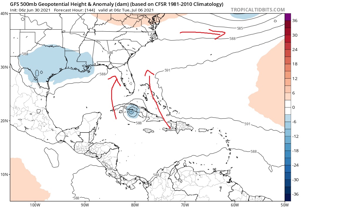
Some speculation you can see the trof on the GFS swing by and weaken the ridge opening the door for 97L to eventually head north. Euro also shows the trof digging
0 likes
-
Shell Mound
- Category 5
- Posts: 2432
- Age: 33
- Joined: Thu Sep 07, 2017 3:39 pm
- Location: St. Petersburg, FL → Scandinavia
Re: ATL: INVEST 97L - Discussion
SFLcane wrote:Some speculation you can see the trof on the GFS swing by and weaken the ridge opening the door for 97L to eventually head north. Euro also shows the trof digging
https://i.postimg.cc/63Hf81jf/yea1.jpg
97L is likely to dissipate around 70°W, however, so I would not focus beyond the Lesser Antilles at this stage. The Windward Islands should watch closely.
Last edited by Shell Mound on Wed Jun 30, 2021 10:00 am, edited 1 time in total.
0 likes
CVW / MiamiensisWx / Shell Mound
The posts in this forum are NOT official forecasts and should not be used as such. They are just the opinion of the poster and may or may not be backed by sound meteorological data. They are NOT endorsed by any professional institution or STORM2K. For official information, please refer to products from the NHC and NWS.

Re: ATL: INVEST 97L - Discussion
SFLcane wrote:Some speculation you can see the trof on the GFS swing by and weaken the ridge opening the door for 97L to eventually head north. Euro also shows the trof digging
https://i.postimg.cc/63Hf81jf/yea1.jpg
Aren't troughs digging into the south this time of year just as whacky as storms forming? Are we just getting an overall weather pattern change early this year? Seems like those puzzle pieces are fitting together nicely. That path looks like a damn October path.
6 likes
Personal Forecast Disclaimer:
The posts in this forum are NOT official forecast and should not be used as such. They are just the opinion of the poster and may or may not be backed by sound meteorological data. They are NOT endorsed by any professional institution or storm2k.org. For official information, please refer to the NHC and NWS products.
The posts in this forum are NOT official forecast and should not be used as such. They are just the opinion of the poster and may or may not be backed by sound meteorological data. They are NOT endorsed by any professional institution or storm2k.org. For official information, please refer to the NHC and NWS products.
Who is online
Users browsing this forum: No registered users and 28 guests