CPAC: JIMENA - Remnants
Moderator: S2k Moderators
-
Yellow Evan

- Professional-Met

- Posts: 16240
- Age: 27
- Joined: Fri Jul 15, 2011 12:48 pm
- Location: Henderson, Nevada/Honolulu, HI
- Contact:
-
cycloneye

- Admin

- Posts: 149505
- Age: 69
- Joined: Thu Oct 10, 2002 10:54 am
- Location: San Juan, Puerto Rico
Re: EPAC: JIMENA - Tropical Depression
Tropical Depression Jimena Discussion Number 16
NWS National Hurricane Center Miami FL EP092021
1100 AM HST Fri Aug 06 2021
During the last 6 hours, deep convection associated with Jimena has
waned. A recently arriving 1756 UTC ASCAT pass revealed peak
believable winds of around 30 kt. The latest Dvorak T- and
CI-numbers from TAFB and SAB have also decreased, and these
data support lowering the initial intensity to 30 kt. Jimena is
currently moving over SSTs near 24C and into a more stable air mass.
In addition, westerly shear will increase along the cyclone's path
during the next 12 hours. These factors should cause continued
weakening, and Jimena is expected to degenerate into a remnant low
by late tonight or early Saturday.
The initial motion estimate is 295/7 kt. The west-northwestward
motion is forecast to continue for another day or so, followed by a
gradual bend to the west as Jimena weakens and is steered by the
low-level trade wind flow. The new track forecast is slightly to
the south of the previous NHC advisory, and is in best agreement
with the HCCA and TVCN consensus models.
Jimena is crossing into the central Pacific basin, and this will be
the final NHC advisory on this system. Future information on Jimena
can be found in Forecast/Advisories issued by the Central Pacific
Hurricane Center beginning at 0300 UTC under AWIPS header HFOTCMCP2
and WMO header WTPA22 PHFO.
FORECAST POSITIONS AND MAX WINDS
INIT 06/2100Z 17.6N 140.0W 30 KT 35 MPH
12H 07/0600Z 18.2N 141.2W 25 KT 30 MPH...POST-TROP/REMNT LOW
24H 07/1800Z 18.8N 142.5W 25 KT 30 MPH...POST-TROP/REMNT LOW
36H 08/0600Z 19.1N 143.9W 20 KT 25 MPH...POST-TROP/REMNT LOW
48H 08/1800Z 19.2N 145.5W 20 KT 25 MPH...POST-TROP/REMNT LOW
60H 09/0600Z...DISSIPATED
$$
Forecaster Hagen/Brown
0 likes
Visit the Caribbean-Central America Weather Thread where you can find at first post web cams,radars
and observations from Caribbean basin members Click Here
and observations from Caribbean basin members Click Here
-
cycloneye
- Admin
- Posts: 149505
- Age: 69
- Joined: Thu Oct 10, 2002 10:54 am
- Location: San Juan, Puerto Rico
Re: CPAC: JIMENA - Remnants
Post-Tropical Cyclone Jimena Discussion Number 17
NWS Central Pacific Hurricane Center Honolulu HI EP092021
500 PM HST Fri Aug 06 2021
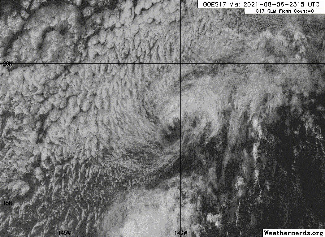
Deep convection near center of Jimena collapsed overnight, and
Jimena consists of a low cloud swirl with shallow convection
flaring along its northern and eastern flanks. Dvorak current
intensity estimates varied from 1.5 at HFO to unclassifiable at SAB,
while CIMSS ADT held onto a 2.0/30 kt. Jimena is moving over sub 24C
sea surface temperatures as it draws in dry air from the north, and
westerly vertical wind shear of more than 15 kt is increasing.
Given its current structure and the hostile environment ahead,
Jimena has been downgraded to a post-tropical remnant low with an
initial intensity of 30 kt.
Post-Tropical Cyclone Jimena will continue to be steered toward the
west-northwest (295 degrees) around 7 kt tonight by a deep
subtropical ridge to the north. Under an environment of cool sea
surface temperatures and continued westerly vertical wind shear,
the increasingly shallow system will move toward the west this
weekend until dissipation.
This is the last advisory issued by the Central Pacific Hurricane
Center on Jimena. Additional information on this system can be
found in the High Seas Forecasts issued by the National Weather
Service in Honolulu under AWIPS header HFOHSFNP and WMO header
FZPN40 PHFO.
FORECAST POSITIONS AND MAX WINDS
INIT 07/0300Z 17.9N 140.8W 30 KT 35 MPH...POST-TROPICAL
12H 07/1200Z 18.5N 142.0W 25 KT 30 MPH...POST-TROP/REMNT LOW
24H 08/0000Z 18.9N 143.3W 25 KT 30 MPH...POST-TROP/REMNT LOW
36H 08/1200Z 19.2N 144.8W 20 KT 25 MPH...POST-TROP/REMNT LOW
48H 09/0000Z...DISSIPATED
$$
Forecaster Wroe
NWS Central Pacific Hurricane Center Honolulu HI EP092021
500 PM HST Fri Aug 06 2021
Deep convection near center of Jimena collapsed overnight, and
Jimena consists of a low cloud swirl with shallow convection
flaring along its northern and eastern flanks. Dvorak current
intensity estimates varied from 1.5 at HFO to unclassifiable at SAB,
while CIMSS ADT held onto a 2.0/30 kt. Jimena is moving over sub 24C
sea surface temperatures as it draws in dry air from the north, and
westerly vertical wind shear of more than 15 kt is increasing.
Given its current structure and the hostile environment ahead,
Jimena has been downgraded to a post-tropical remnant low with an
initial intensity of 30 kt.
Post-Tropical Cyclone Jimena will continue to be steered toward the
west-northwest (295 degrees) around 7 kt tonight by a deep
subtropical ridge to the north. Under an environment of cool sea
surface temperatures and continued westerly vertical wind shear,
the increasingly shallow system will move toward the west this
weekend until dissipation.
This is the last advisory issued by the Central Pacific Hurricane
Center on Jimena. Additional information on this system can be
found in the High Seas Forecasts issued by the National Weather
Service in Honolulu under AWIPS header HFOHSFNP and WMO header
FZPN40 PHFO.
FORECAST POSITIONS AND MAX WINDS
INIT 07/0300Z 17.9N 140.8W 30 KT 35 MPH...POST-TROPICAL
12H 07/1200Z 18.5N 142.0W 25 KT 30 MPH...POST-TROP/REMNT LOW
24H 08/0000Z 18.9N 143.3W 25 KT 30 MPH...POST-TROP/REMNT LOW
36H 08/1200Z 19.2N 144.8W 20 KT 25 MPH...POST-TROP/REMNT LOW
48H 09/0000Z...DISSIPATED
$$
Forecaster Wroe
0 likes
Visit the Caribbean-Central America Weather Thread where you can find at first post web cams,radars
and observations from Caribbean basin members Click Here
and observations from Caribbean basin members Click Here
-
Sciencerocks
- Category 5

- Posts: 10186
- Age: 40
- Joined: Thu Jul 06, 2017 1:51 am
Who is online
Users browsing this forum: No registered users and 59 guests