ATL: PETER - Remnants - Discussion
Moderator: S2k Moderators
-
hurricanes1234
- Category 5

- Posts: 2908
- Joined: Sat Jul 28, 2012 6:19 pm
- Location: Trinidad and Tobago
Re: ATL: INVEST 95L - Discussion
Glad they lowered the chances. I would expect further reductions in subsequent TWOs.
3 likes
PLEASE NOTE: With the exception of information from weather agencies that I may copy and paste here, my posts will NEVER be official, since I am NOT a meteorologist. They are solely my amateur opinion, and may or may not be accurate. Therefore, please DO NOT use them as official details, particularly when making important decisions. Thank you.


-
AutoPenalti
- Category 5
- Posts: 4091
- Age: 29
- Joined: Mon Aug 17, 2015 4:16 pm
- Location: Ft. Lauderdale, Florida
Re: ATL: INVEST 95L - Discussion
This may be a sleeper wave now.
0 likes
The posts in this forum are NOT official forecasts and should not be used as such. They are just the opinion of the poster and may or may not be backed by sound meteorological data. They are NOT endorsed by any professional institution or STORM2K. For official information, please refer to products from the NHC and NWS.
Model Runs Cheat Sheet:
GFS (5:30 AM/PM, 11:30 AM/PM)
HWRF, GFDL, UKMET, NAVGEM (6:30-8:00 AM/PM, 12:30-2:00 AM/PM)
ECMWF (1:45 AM/PM)
TCVN is a weighted averaged
-
Stormybajan

- Category 1

- Posts: 453
- Joined: Thu May 20, 2021 3:21 pm
- Location: Windward Islands
Re: ATL: INVEST 95L - Discussion
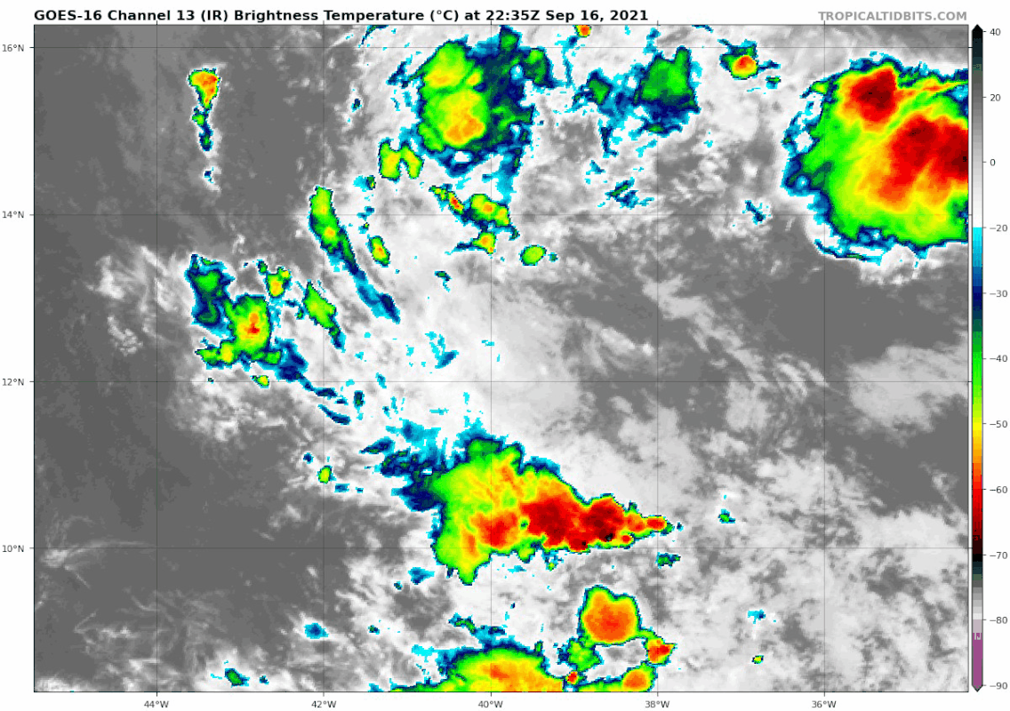
gatorcane wrote:Looks really disorganized, 60% looks generous:
https://i.postimg.cc/FHW1DFM9/goes16-ir-95-L-202109162235.gif
The way its struggling you would think its July and not checks notes , Cape Verde peak season September 16th
1 likes
Sad West Indies and Manchester United fan ⚽️
-
AlphaToOmega
- Category 5
- Posts: 1448
- Joined: Sat Jun 26, 2021 10:51 am
- Location: Somewhere in Massachusetts
Re: ATL: INVEST 95L - Discussion
I still think this will develop. There is still strong model support.
1 likes
-
AlphaToOmega
- Category 5
- Posts: 1448
- Joined: Sat Jun 26, 2021 10:51 am
- Location: Somewhere in Massachusetts
Re: ATL: INVEST 95L - Discussion
If this failed to develop, it would be an embarrassment to the GEFS and the ECENS. That is a big if
0 likes
Re: ATL: INVEST 95L - Discussion
I think it will develop, but it won't be very strong. It's going to have a window where it can develop and strengthen but I wouldn't expect anything more than a cat 2 before it runs into a more unfavorable environment due to the TUTT.
Last edited by IcyTundra on Thu Sep 16, 2021 8:47 pm, edited 1 time in total.
0 likes
-
AlphaToOmega
- Category 5
- Posts: 1448
- Joined: Sat Jun 26, 2021 10:51 am
- Location: Somewhere in Massachusetts
Re: ATL: INVEST 95L - Discussion
It is a terrible idea to use satellite presentation to determine if a system will develop: what matters is what is under the hood. ASCAT almost shows a closed circulation.
2 likes
-
ElectricStorm

- Category 5
- Posts: 5148
- Age: 25
- Joined: Tue Aug 13, 2019 11:23 pm
- Location: Norman, OK
Re: ATL: INVEST 95L - Discussion
AlphaToOmega wrote:It is a terrible idea to use satellite presentation to determine if a system will develop: what matters is what is under the hood. ASCAT almost shows a closed circulation.
But a TC is closed circulation AND strong convection. Not just a closed circulation. This hardly has any convection right now.
4 likes
B.S Meteorology, University of Oklahoma '25
Please refer to the NHC, NWS, or SPC for official information.
Please refer to the NHC, NWS, or SPC for official information.
-
cycloneye

- Admin

- Posts: 149525
- Age: 69
- Joined: Thu Oct 10, 2002 10:54 am
- Location: San Juan, Puerto Rico
Re: ATL: INVEST 95L - Discussion
AlphaToOmega wrote:It is a terrible idea to use satellite presentation to determine if a system will develop: what matters is what is under the hood. ASCAT almost shows a closed circulation.
Do you have that ASCAT pass?
0 likes
Visit the Caribbean-Central America Weather Thread where you can find at first post web cams,radars
and observations from Caribbean basin members Click Here
and observations from Caribbean basin members Click Here

Re: ATL: INVEST 95L - Discussion
cycloneye wrote:AlphaToOmega wrote:It is a terrible idea to use satellite presentation to determine if a system will develop: what matters is what is under the hood. ASCAT almost shows a closed circulation.
Do you have that ASCAT pass?
There is a 'closed' circulation down around 9-10N north.

The GFS resolved this exact feature well. It amplified/developed the north end of the wave axis, which is currently just an axis as it depicts.

5 likes
Kendall -> SLO -> PBC
Memorable Storms: Katrina (for its Florida landfall...) Wilma Matthew Irma
Memorable Storms: Katrina (for its Florida landfall...) Wilma Matthew Irma
-
CyclonicFury

- Category 5
- Posts: 2035
- Age: 27
- Joined: Sun Jul 02, 2017 12:32 pm
- Location: NC
- Contact:
Re: ATL: INVEST 95L - Discussion
Very elongated. 95L has a lot of work to do to ever become a TC.

3 likes
NCSU B.S. in Meteorology Class of 2021. Tropical weather blogger at http://www.cyclonicfury.com. My forecasts and thoughts are NOT official, for official forecasts please consult the National Hurricane Center.
-
Sciencerocks
- Category 5
- Posts: 10186
- Age: 40
- Joined: Thu Jul 06, 2017 1:51 am


Re: ATL: INVEST 95L - Discussion
If we don’t have improving convection by tonight, this will either not develop at all, or it’ll wait until after the TUTT to develop like the CMC has been showing. The latter scenario is rather concerning because while there is an escape route thanks to 96L, this could get quite close to the Bahamas and/or Bermuda.
0 likes
Irene '11 Sandy '12 Hermine '16 5/15/2018 Derecho Fay '20 Isaias '20 Elsa '21 Henri '21 Ida '21
I am only a meteorology enthusiast who knows a decent amount about tropical cyclones. Look to the professional mets, the NHC, or your local weather office for the best information.
I am only a meteorology enthusiast who knows a decent amount about tropical cyclones. Look to the professional mets, the NHC, or your local weather office for the best information.

Re: ATL: INVEST 95L - Discussion
Looks like there is some strengthening of 700mb vort.
925 mb vort seems to be consolidating a bit as well along 10N, SE of the 700mb vort.
925 mb vort seems to be consolidating a bit as well along 10N, SE of the 700mb vort.
1 likes
Re: ATL: INVEST 95L - Discussion
Teban54 wrote:IcyTundra wrote:Another MDR system that is going to have issues developing seems like the trend ever since the 2018 season.
2018 had C2 Helene (almost a major in the eastern MDR), C1 Isaac and C1 Florence that became a C4 just north of the MDR boundaries. 2019 had C4 Lorenzo and C2 Jerry. 2020 had C4 Teddy. 2021 had C3 Larry. They definitely don't count as struggling to me, unless the comparison uses 2004/10/17 as baselines.
I'm also not sure if that's indeed a trend or just a coincidence of unfortunate random factors. 2018 had a developing El Nino, 2020 had a typhoon-induced TUTT, and 2021 had a weird cycle of intraseasonal signals. Especially 2020 and 2021 - these factors are pretty much out of control even with favorable conditions otherwise.
2018 looks to me like the MDR wasn't that great for tropical cyclones. Florence didn't get going until moving north into the sub-tropics. There were a couple of very short lived minimal hurricanes in the MDR itself, and one that recurved very far east, and the rest were weak tropical storms.
2019 is more difficult to judge because MDR storms curved north soon after forming, there were no systems tracking west for a long time. There were seven MDR storms, four of them didn't get past tropical storm strength, one didn't whilst in the MDR and strengthened near the Lesser Antilles, eventually becoming a devestating cat 5 landfall on the Bahamas. Only two storms reached hurricane strength in the MDR, and they were well on their way out of the MDR at that time. It looks to me that if anything had tracked due west towards the Caribbean sea, it would have been like 2020 and got ripped apart.
2020 had one cat 4 which formed in the MDR but didn't strengthen to a major until it was well north of the MDR. Aside from that one storm, there were a ton of systems that couldn't strengthen beyond tropical storm strength anywhere in the tropical Atlantic and either strengthened after moving into the Caribbean sea/Gulf, the sub-tropics, or went poof. It is fair to say the MDR last year was not favourable for tropical cyclones. There were far more hurricanes in the sub-tropics than the MDR last year.
Overall I would say it is fair to claim that MDR tropical cyclone development has been hampered since 2017. Looks like this year is going the same way. Larry is the one exception out of several systems that tracked across the MDR and couldn't get past tropical storm strength (again), and now we have a tropical wave which had a 90% chance of development at the peak of the season which has stubbornly refused to develop.
2 likes
Re: ATL: INVEST 95L - Discussion
Current GFS weakens the Virgin Island TUTT quite a bit and moves it north as the wave approaches.
Chances looking better for development in the Carib or Bahamas.
Chances looking better for development in the Carib or Bahamas.
1 likes
-
jconsor
- Professional-Met

- Posts: 580
- Joined: Mon Jun 30, 2008 9:31 pm
- Location: Jerusalem, Israel
- Contact:
Re: ATL: INVEST 95L - Discussion
Don't count out 95L yet. However chance of direct impacts to US remains low.
https://twitter.com/yconsor/status/1438850948122693633
https://twitter.com/yconsor/status/1438854228441812995
https://twitter.com/yconsor/status/1438850948122693633
https://twitter.com/yconsor/status/1438854228441812995
0 likes

Re: ATL: INVEST 95L - Discussion
Looks like I am in the cone again! 
0 likes
Too many hurricanes to remember
Re: ATL: INVEST 95L - Discussion
This may be trying to consolidate around 12.5-13.0N, based on visible/IR imagery. Let’s see if this keeps up.
1 likes
Irene '11 Sandy '12 Hermine '16 5/15/2018 Derecho Fay '20 Isaias '20 Elsa '21 Henri '21 Ida '21
I am only a meteorology enthusiast who knows a decent amount about tropical cyclones. Look to the professional mets, the NHC, or your local weather office for the best information.
I am only a meteorology enthusiast who knows a decent amount about tropical cyclones. Look to the professional mets, the NHC, or your local weather office for the best information.
Who is online
Users browsing this forum: No registered users and 77 guests