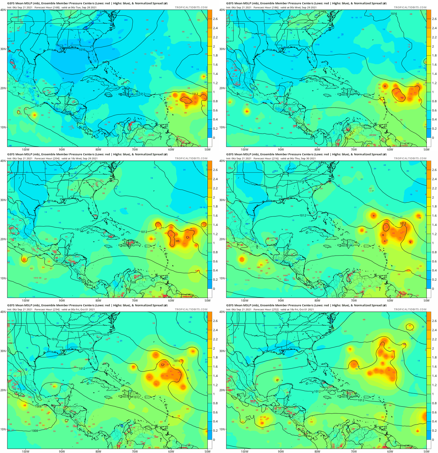
Semantics aside I think what you said still makes lots of sense based upon the projected conditions in that particular model run at that particular period. If it were to verify as shown up to that point, we in Florida and the CONUS east coast in general would not have much to be worried about. Of course there are a ton of 'ifs' in that statement. I do think that given climo the chances of significant impact from 98L and whatever comes of it on the CONUS are very minimal as things stand now.tolakram wrote:Cat5James wrote:tolakram wrote:Here's the 0Z euro 250mb chart at 240 hours. Looks to me like Florida and the gulf still out of play, or at least any storm will be significantly ripped up if it moves through that shear zone.
https://i.imgur.com/ll6VNWT.png
You can’t look at the Euro/CMC and say anyone is “out of play”…. High pressure is building back in to the north on both of those runs
Sure, fair enough, I was careless with the wording, and this run is different from the previous 0Z run. What I intended to say is not that Florida is out of play but the Euro is showing conditions that would rip any storm up. At 240 hours all this map represents is most likely what won't happen. This is different, in my opinion, from saying Florida is safe, it most certainly is not, but reading it back it looks like I'm calling the all clear.
ATL: SAM - Models
Moderator: S2k Moderators
-
otowntiger
- Category 5

- Posts: 1932
- Joined: Tue Aug 31, 2004 7:06 pm
Re: ATL: INVEST 98L - Models
1 likes
Re: ATL: INVEST 98L - Models
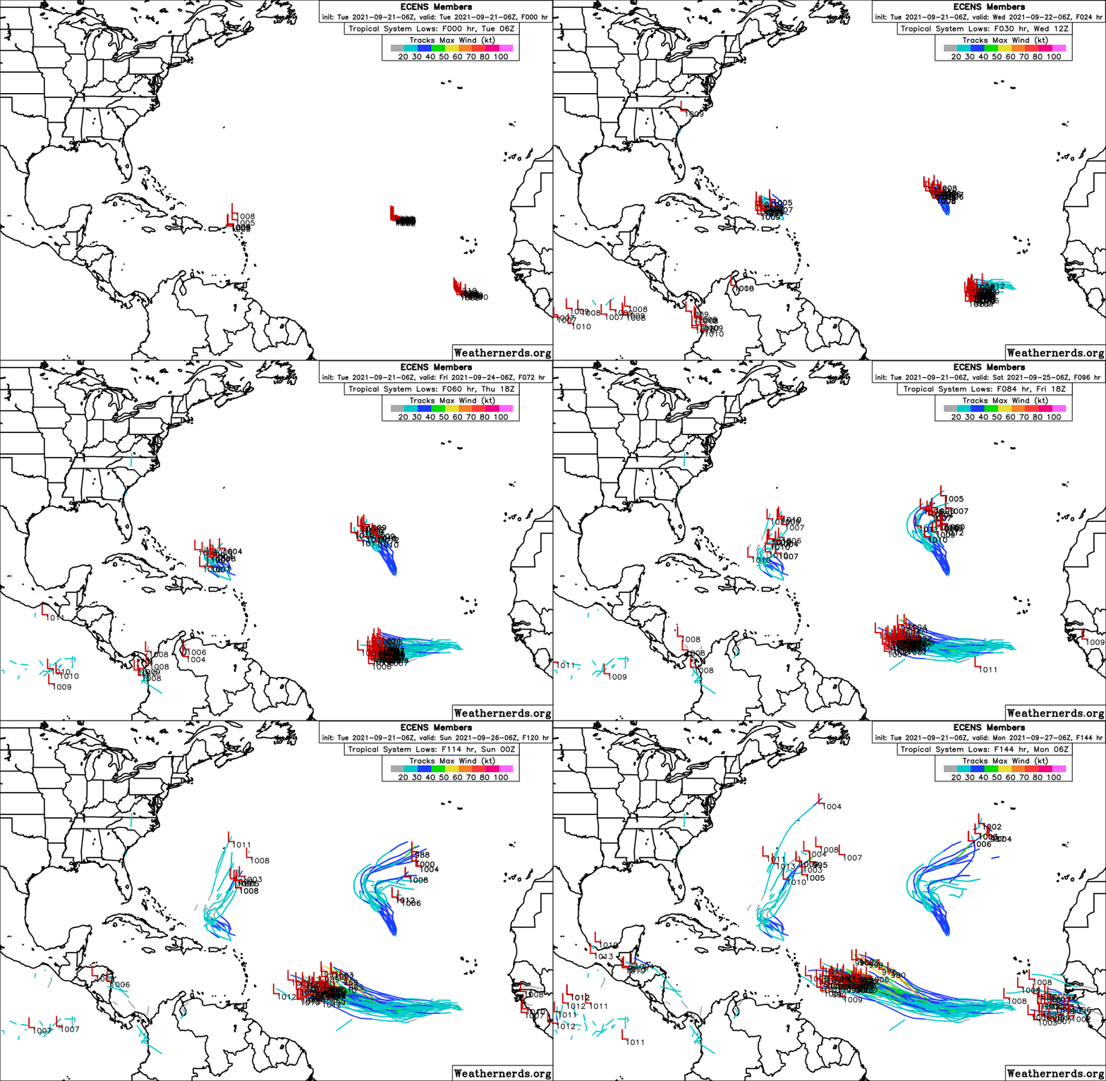
SFLcane wrote::crazyeyes:
https://i.postimg.cc/SxqXQyw4/EDF08-C0-C-E1-C0-457-E-8-CDC-9-A659-A79179-B.gif
Also interesting to see how there's a split between the members that become strong soon (further north) and the ones that take a bit longer to develop (the large southern cluster). Unfortunately, it looks like 98L might still take a while to get going which would mean the more western tracks with a larger chance of land impacts might be more realistic.
0 likes
Re: ATL: INVEST 98L - Models
SFLcane wrote::crazyeyes:
https://i.postimg.cc/SxqXQyw4/EDF08-C0-C-E1-C0-457-E-8-CDC-9-A659-A79179-B.gif
Another CAG system showing up?
0 likes
Personal Forecast Disclaimer:
The posts in this forum are NOT official forecast and should not be used as such. They are just the opinion of the poster and may or may not be backed by sound meteorological data. They are NOT endorsed by any professional institution or storm2k.org. For official information, please refer to the NHC and NWS products.
The posts in this forum are NOT official forecast and should not be used as such. They are just the opinion of the poster and may or may not be backed by sound meteorological data. They are NOT endorsed by any professional institution or storm2k.org. For official information, please refer to the NHC and NWS products.
-
otowntiger
- Category 5

- Posts: 1932
- Joined: Tue Aug 31, 2004 7:06 pm
-
AutoPenalti
- Category 5

- Posts: 4091
- Age: 29
- Joined: Mon Aug 17, 2015 4:16 pm
- Location: Ft. Lauderdale, Florida
Re: ATL: INVEST 98L - Models
Looks like 98L will be moving into a suppressed phase of the Kelvin Wave, which is why slower development is possible, likely affecting track downstream.
https://twitter.com/AndyHazelton/status/1440311324064374787
https://twitter.com/AndyHazelton/status/1440313866009808913
https://twitter.com/AndyHazelton/status/1440311324064374787
https://twitter.com/AndyHazelton/status/1440313866009808913
0 likes
The posts in this forum are NOT official forecasts and should not be used as such. They are just the opinion of the poster and may or may not be backed by sound meteorological data. They are NOT endorsed by any professional institution or STORM2K. For official information, please refer to products from the NHC and NWS.
Model Runs Cheat Sheet:
GFS (5:30 AM/PM, 11:30 AM/PM)
HWRF, GFDL, UKMET, NAVGEM (6:30-8:00 AM/PM, 12:30-2:00 AM/PM)
ECMWF (1:45 AM/PM)
TCVN is a weighted averaged
- skyline385
- Category 5

- Posts: 2728
- Age: 35
- Joined: Wed Aug 26, 2020 11:15 pm
- Location: Houston TX
ATL: INVEST 98L - Models
AutoPenalti wrote:Looks like 98L will be moving into a suppressed phase of the Kelvin Wave, which is why slower development is possible, likely affecting track downstream.
https://twitter.com/AndyHazelton/status/1440311324064374787
https://twitter.com/AndyHazelton/status/1440313866009808913
CSU biweekly report had forecasted the same as well, they were predicting average tropical activity due to the suppressed phase of the Kelvin wave over the Atlantic for the next two weeks...
0 likes
Re: ATL: INVEST 98L - Models
otowntiger wrote:HUGE swing east from the 0z run.
Worth reminding people that as of this moment, GFS is huge outlier. All other modeling used by NHC shows different story, for now
3 likes
-
otowntiger
- Category 5

- Posts: 1932
- Joined: Tue Aug 31, 2004 7:06 pm
Re: ATL: INVEST 98L - Models
Good point and thanks for the reminder. Certainly no conclusions can be made about any model this far out. However it is noteworthy since it is one of the top two or three models they rely upon. Others could swing toward the GFS or vice versa in the coming days.sma10 wrote:otowntiger wrote:HUGE swing east from the 0z run.
Worth reminding people that as of this moment, GFS is huge outlier. All other modeling used by NHC shows different story, for now
0 likes
Re: ATL: INVEST 98L - Models
otowntiger wrote:Good point and thanks for the reminder. Certainly no conclusions can be made about any model this far out. However it is noteworthy since it is one of the top two or three models they rely upon. Others could swing toward the GFS or vice versa in the coming days.sma10 wrote:otowntiger wrote: HUGE swing east from the 0z run.
Worth reminding people that as of this moment, GFS is huge outlier. All other modeling used by NHC shows different story, for now
Agree - or the correct solution might be a blend. That's what will make the 12z UK and Euro interesting.
1 likes
-
grapealcoholic
- Category 2

- Posts: 703
- Joined: Tue Aug 10, 2021 3:26 pm
Re: ATL: INVEST 98L - Models
SFLcane wrote::crazyeyes:
https://i.postimg.cc/SxqXQyw4/EDF08-C0-C-E1-C0-457-E-8-CDC-9-A659-A79179-B.gif
This is a very tight spread as far as ensemble runs go. PR should watch this one very closely
0 likes
- Fego
- S2K Supporter

- Posts: 767
- Age: 66
- Joined: Sun Apr 18, 2004 7:58 pm
- Location: San Juan, Puerto Rico
- Contact:
Re: ATL: INVEST 98L - Models
grapealcoholic wrote:SFLcane wrote::crazyeyes:
https://i.postimg.cc/SxqXQyw4/EDF08-C0-C-E1-C0-457-E-8-CDC-9-A659-A79179-B.gif
This is a very tight spread as far as ensemble runs go. PR should watch this one very closely
We are... very closely. Thanks.
I think 98l will take longer to develop, than predicted by the models.
3 likes
Go Giants! Go Niners! Go Warriors!
-
AutoPenalti
- Category 5

- Posts: 4091
- Age: 29
- Joined: Mon Aug 17, 2015 4:16 pm
- Location: Ft. Lauderdale, Florida
Re: ATL: INVEST 98L - Models
GFS backing down on intensity in the short term so far.
0 likes
The posts in this forum are NOT official forecasts and should not be used as such. They are just the opinion of the poster and may or may not be backed by sound meteorological data. They are NOT endorsed by any professional institution or STORM2K. For official information, please refer to products from the NHC and NWS.
Model Runs Cheat Sheet:
GFS (5:30 AM/PM, 11:30 AM/PM)
HWRF, GFDL, UKMET, NAVGEM (6:30-8:00 AM/PM, 12:30-2:00 AM/PM)
ECMWF (1:45 AM/PM)
TCVN is a weighted averaged
Re: ATL: INVEST 98L - Models
12z GFS has a TC by midday Friday. Prior to Thursday, 98L remains convectively weak.
0 likes
Irene '11 Sandy '12 Hermine '16 5/15/2018 Derecho Fay '20 Isaias '20 Elsa '21 Henri '21 Ida '21
I am only a meteorology enthusiast who knows a decent amount about tropical cyclones. Look to the professional mets, the NHC, or your local weather office for the best information.
I am only a meteorology enthusiast who knows a decent amount about tropical cyclones. Look to the professional mets, the NHC, or your local weather office for the best information.
Re: ATL: INVEST 98L - Models
Let's hope it doesn't hit Puerto Rico. They can't take another cat 4
0 likes
Very useful information on the Dvorak Technique --
https://severe.worldweather.wmo.int/TCF ... kBeven.pdf
https://severe.worldweather.wmo.int/TCF ... kBeven.pdf
-
grapealcoholic
- Category 2

- Posts: 703
- Joined: Tue Aug 10, 2021 3:26 pm
-
AutoPenalti
- Category 5

- Posts: 4091
- Age: 29
- Joined: Mon Aug 17, 2015 4:16 pm
- Location: Ft. Lauderdale, Florida
Re: ATL: INVEST 98L - Models
Trough is still there though, I wonder if it will pick it up.
0 likes
The posts in this forum are NOT official forecasts and should not be used as such. They are just the opinion of the poster and may or may not be backed by sound meteorological data. They are NOT endorsed by any professional institution or STORM2K. For official information, please refer to products from the NHC and NWS.
Model Runs Cheat Sheet:
GFS (5:30 AM/PM, 11:30 AM/PM)
HWRF, GFDL, UKMET, NAVGEM (6:30-8:00 AM/PM, 12:30-2:00 AM/PM)
ECMWF (1:45 AM/PM)
TCVN is a weighted averaged
-
otowntiger
- Category 5

- Posts: 1932
- Joined: Tue Aug 31, 2004 7:06 pm
Re: ATL: INVEST 98L - Models
well I don't know if I'd say 'like the Euro' in that it appears to still be pretty far right of the Euro. It is (a little) further west than previous runs, it appears, but will still miss the Islands by several hundred miles and seems to be doing another clear OTS solution.grapealcoholic wrote:12z GFS coming in further south like the euro
Last edited by otowntiger on Tue Sep 21, 2021 11:36 am, edited 2 times in total.
0 likes
-
grapealcoholic
- Category 2

- Posts: 703
- Joined: Tue Aug 10, 2021 3:26 pm
Re: ATL: INVEST 98L - Models
AutoPenalti wrote:Trough is still there though, I wonder if it will pick it up.
I'm not buying that phantom trough placement tbh. Also still really far out for that area to resolve
0 likes
Who is online
Users browsing this forum: No registered users and 25 guests


