ATL: SAM - Remnants - Discussion

Moderator: S2k Moderators

Message
Author
User avatar
cheezyWXguy
Category 5
Category 5
Posts: 6108
Joined: Mon Feb 13, 2006 12:29 am
Location: Dallas, TX

Re: ATL: SAM - Hurricane - Discussion

#1921 Postby cheezyWXguy » Fri Oct 01, 2021 12:54 am

Shell Mound wrote:This is easily the weakest-looking 130-kt system that I have seen on satellite, given lingering southwestern shear, the large, some what ragged eye, and the fairly warm, expansive CDO. Dorian, by contrast, was less sheared and far better organized. I wonder whether those FL winds are mixing to the surface. Also, 936 mb is a relatively high MSLP for a large 130-kt system at Sam's current cooordinates, near the subtropics. I am not a professional, of course, but maybe surface winds are lower than FL would suggest.

Looks pretty good to me
6 likes   

grapealcoholic
Category 2
Category 2
Posts: 684
Joined: Tue Aug 10, 2021 3:26 pm

Re: ATL: SAM - Hurricane - Discussion

#1922 Postby grapealcoholic » Fri Oct 01, 2021 12:57 am

936 is lower than Laura's peak
1 likes   

User avatar
beoumont
Category 1
Category 1
Posts: 473
Joined: Sun Jul 10, 2011 4:13 pm
Location: East Central Florida
Contact:

Re: ATL: SAM - Hurricane - Discussion

#1923 Postby beoumont » Fri Oct 01, 2021 12:57 am

Quite a satellite study of an intense MATURE hurricane. One thing to my recollection: the relatively not-so-cold cloud tops in the central core is quite rare for such an intense system.
Last edited by beoumont on Fri Oct 01, 2021 1:44 am, edited 1 time in total.
4 likes   
List of 79 tropical cyclones intercepted by Richard Horodner:
http://www.canebeard.com/page/page/572246.htm

User avatar
cheezyWXguy
Category 5
Category 5
Posts: 6108
Joined: Mon Feb 13, 2006 12:29 am
Location: Dallas, TX

Re: ATL: SAM - Hurricane - Discussion

#1924 Postby cheezyWXguy » Fri Oct 01, 2021 1:12 am

It’s pretty amazing to me that there was not one, but 4 consecutive obs at or above 145kt FL. Usually you’re lucky to get a brief spike. Did any storm last year have FL winds this strong?
0 likes   

grapealcoholic
Category 2
Category 2
Posts: 684
Joined: Tue Aug 10, 2021 3:26 pm

Re: ATL: SAM - Hurricane - Discussion

#1925 Postby grapealcoholic » Fri Oct 01, 2021 1:22 am

It's getting a huge boost from the trough via divergence; also there's stronger coriolisis effect at Sam's latitude
1 likes   

User avatar
Yellow Evan
Professional-Met
Professional-Met
Posts: 16143
Age: 27
Joined: Fri Jul 15, 2011 12:48 pm
Location: Henderson, Nevada/Honolulu, HI
Contact:

Re: ATL: SAM - Hurricane - Discussion

#1926 Postby Yellow Evan » Fri Oct 01, 2021 1:38 am

Image

Way outrunning Dvorak here.
0 likes   

Sciencerocks
Category 5
Category 5
Posts: 9154
Age: 39
Joined: Thu Jul 06, 2017 1:51 am

Re: ATL: SAM - Hurricane - Discussion

#1927 Postby Sciencerocks » Fri Oct 01, 2021 1:40 am

Is there any cat5's north of 26 and east of 70 and west of 50 in recorded history???

Closes
Dorian
Andrew
1938 hurricane
1932 Great bahama hurricane
0 likes   

User avatar
kevin
Category 5
Category 5
Posts: 2586
Age: 26
Joined: Wed Aug 28, 2019 4:35 am

Re: ATL: SAM - Hurricane - Discussion

#1928 Postby kevin » Fri Oct 01, 2021 1:57 am

Hopefully they can do one more NE pass, the strongest winds are clearly in quadrant.
0 likes   

grapealcoholic
Category 2
Category 2
Posts: 684
Joined: Tue Aug 10, 2021 3:26 pm

Re: ATL: SAM - Hurricane - Discussion

#1929 Postby grapealcoholic » Fri Oct 01, 2021 2:01 am

Need some convection to wrap around that NE side
0 likes   

bob rulz
Category 5
Category 5
Posts: 1704
Age: 35
Joined: Sat Jan 28, 2006 7:30 pm
Location: Salt Lake City, Utah

Re: ATL: SAM - Hurricane - Discussion

#1930 Postby bob rulz » Fri Oct 01, 2021 2:03 am


This shows just how vital recon is. Same with Dorian 2019. Dvorak is usually pretty close, but sometimes it's way off and it's important to understand why.
1 likes   

User avatar
kevin
Category 5
Category 5
Posts: 2586
Age: 26
Joined: Wed Aug 28, 2019 4:35 am

Re: ATL: SAM - Hurricane - Discussion

#1931 Postby kevin » Fri Oct 01, 2021 2:04 am

The most impressive thing about Sam is just how long he's been able to stay this strong despite forecast saying that he should weaken. An advisory from 3 days ago said that Sam should be weakening and back to 110 kt right now, but instead FL winds indicate that it's still a 130-135 kt monster.
3 likes   

User avatar
kevin
Category 5
Category 5
Posts: 2586
Age: 26
Joined: Wed Aug 28, 2019 4:35 am

Re: ATL: SAM - Hurricane - Discussion

#1932 Postby kevin » Fri Oct 01, 2021 2:19 am

Looks like recon is leaving. Next one arrives in 10 hours. I really thought Sam should be weakening by now, but he keeps surprising me so who knows what the next recon will find.
0 likes   

User avatar
kevin
Category 5
Category 5
Posts: 2586
Age: 26
Joined: Wed Aug 28, 2019 4:35 am

Re: ATL: SAM - Hurricane - Discussion

#1933 Postby kevin » Fri Oct 01, 2021 2:28 am

cheezyWXguy wrote:It’s pretty amazing to me that there was not one, but 4 consecutive obs at or above 145kt FL. Usually you’re lucky to get a brief spike. Did any storm last year have FL winds this strong?


Highest FL winds found in last year's MHs, all sourced from the official NHC reports. Thresholds are based on a 0.9 conversion factor.

--- cat 5 threshold = 152 kt
Laura = 148 kt
Sam (2021) = 147 kt
Iota = 147 kt
Eta = 137 kt
Delta = 132 kt
Teddy = 130 kt
--- cat 4 threshold = 126 kt
Zeta = 119 kt
Epsilon = 110 kt
--- cat 3 threshold = 107 kt
6 likes   

User avatar
kevin
Category 5
Category 5
Posts: 2586
Age: 26
Joined: Wed Aug 28, 2019 4:35 am

Re: ATL: SAM - Hurricane - Discussion

#1934 Postby kevin » Fri Oct 01, 2021 3:19 am

One of these is a 130 kt cat 4, the other one a 160 kt cat 5. If you didn't know which storms they are I can imagine you might accidentally assign the intensity the wrong way around. Sam is another case more similar to Dorian where the intensity outperforms the IR based estimates.

Image

Image
8 likes   

grapealcoholic
Category 2
Category 2
Posts: 684
Joined: Tue Aug 10, 2021 3:26 pm

Re: ATL: SAM - Hurricane - Discussion

#1935 Postby grapealcoholic » Fri Oct 01, 2021 3:22 am

Of course Sam starts ripping after recon leaves lol
0 likes   

User avatar
Ubuntwo
Category 5
Category 5
Posts: 1406
Age: 31
Joined: Thu Oct 05, 2017 10:41 pm

Re: ATL: SAM - Hurricane - Discussion

#1936 Postby Ubuntwo » Fri Oct 01, 2021 3:49 am

Shell Mound wrote:This is easily the weakest-looking 130-kt system that I have seen on satellite, given lingering southwestern shear, the large, some what ragged eye, and the fairly warm, expansive CDO. Dorian, by contrast, was less sheared and far better organized. I wonder whether those FL winds are mixing to the surface. Also, 936 mb is a relatively high MSLP for a large 130-kt system at Sam's current cooordinates, near the subtropics. I am not a professional, of course, but maybe surface winds are lower than FL would suggest.

KZC analysis for Sam right now comes out to 129.2kt.
0 likes   
Kendall -> SLO -> PBC

Memorable Storms: Katrina (for its Florida landfall...) Wilma Matthew Irma

SteveM
Tropical Depression
Tropical Depression
Posts: 76
Joined: Wed Jul 22, 2020 8:21 am

Re: ATL: SAM - Hurricane - Discussion

#1937 Postby SteveM » Fri Oct 01, 2021 4:24 am

As others have mentioned, the cloud tops are warmer than one might expect. Do I see slight contraction of the eye, though?
0 likes   

User avatar
FLpanhandle91
Category 5
Category 5
Posts: 1033
Age: 34
Joined: Mon Sep 13, 2010 3:50 pm
Location: Fort Walton Beach, FL

Re: ATL: SAM - Hurricane - Discussion

#1938 Postby FLpanhandle91 » Fri Oct 01, 2021 6:45 am

Warm eyes can do more for a storm than cold convection in a lot of cases.
1 likes   

User avatar
aspen
Category 5
Category 5
Posts: 8818
Joined: Sat Oct 12, 2019 7:10 pm
Location: Connecticut, USA

Re: ATL: SAM - Hurricane - Discussion

#1939 Postby aspen » Fri Oct 01, 2021 6:52 am

I’m doubtful the next recon mission will still find a 130 kt Cat 4; Sam is probably down to 125 kt now IMO. Regardless, it’ll most likely hit 40 ACE sometime today, and the longer it holds on to Cat 4 status, the better shot it has at hitting 50 ACE.
0 likes   
Irene '11 Sandy '12 Hermine '16 5/15/2018 Derecho Fay '20 Isaias '20 Elsa '21 Henri '21 Ida '21

I am only a meteorology enthusiast who knows a decent amount about tropical cyclones. Look to the professional mets, the NHC, or your local weather office for the best information.

User avatar
beoumont
Category 1
Category 1
Posts: 473
Joined: Sun Jul 10, 2011 4:13 pm
Location: East Central Florida
Contact:

Re: ATL: SAM - Hurricane - Discussion

#1940 Postby beoumont » Fri Oct 01, 2021 7:06 am

Sciencerocks wrote:Is there any cat5's north of 26 and east of 70 and west of 50 in recorded history???

Closes
Dorian
Andrew
1938 hurricane
1932 Great bahama hurricane


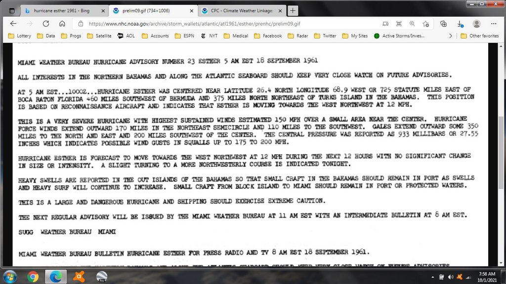
Hurricane Esther 1961. 26.4 n / 68.9 w. 150 mph sustained, gusts 175-200. Gales extend 350 miles NE, 200 SW. Hurricane winds 170 miles NE, 110 SW.

<<<<However, reanalysis as part of the Atlantic hurricane reanalysis project concluded that Esther was in fact a Category 5 hurricane with winds of 160 mph (260 km/h) and a minimum pressure of 919 mbar (91.9 kPa; 27.1 inHg); this has now been officially incorporated into HURDAT.[6]>>>>>>

On September 16, a Navy plane flew into the eye of Esther about 400 miles (644 km) northeast of Puerto Rico, and dropped canisters of silver iodide into the storm. (not spinach, Popeye.) hurricane appeared to weaken slightly in response to the seeding, reportedly by ten percent. This weakening was temporary, however, as the hurricane resumed strengthening shortly after

Image
Last edited by beoumont on Fri Oct 01, 2021 7:45 am, edited 4 times in total.
4 likes   
List of 79 tropical cyclones intercepted by Richard Horodner:
http://www.canebeard.com/page/page/572246.htm


Return to “2021”

Who is online

Users browsing this forum: No registered users and 6 guests