https://twitter.com/philklotzbach/status/1443905715865669634
ATL: SAM - Remnants - Discussion
Moderator: S2k Moderators
-
cycloneye

- Admin

- Posts: 149508
- Age: 69
- Joined: Thu Oct 10, 2002 10:54 am
- Location: San Juan, Puerto Rico
Re: ATL: SAM - Hurricane - Discussion
0 likes
Visit the Caribbean-Central America Weather Thread where you can find at first post web cams,radars
and observations from Caribbean basin members Click Here
and observations from Caribbean basin members Click Here
-
cheezyWXguy

- Category 5

- Posts: 6282
- Joined: Mon Feb 13, 2006 12:29 am
- Location: Dallas, TX
Re: ATL: SAM - Hurricane - Discussion
It’s funny how sw shear seems to pick up a little bit every night around the same time and then gradually ease as the day goes on. Is this the 3rd or 4th day in a row that this has happened?
0 likes

Re: ATL: SAM - Hurricane - Discussion
Sam is a storm I would’ve expected between late August and mid September, not late September into early October. Who would’ve expected a 40 ACE long-tracking Cape Verde major intensifying to 130 kt at 28N/62W on October 1st?
5 likes
Irene '11 Sandy '12 Hermine '16 5/15/2018 Derecho Fay '20 Isaias '20 Elsa '21 Henri '21 Ida '21
I am only a meteorology enthusiast who knows a decent amount about tropical cyclones. Look to the professional mets, the NHC, or your local weather office for the best information.
I am only a meteorology enthusiast who knows a decent amount about tropical cyclones. Look to the professional mets, the NHC, or your local weather office for the best information.
Re: ATL: SAM - Hurricane - Discussion
Is there going to be another recon flight today?
Edit: AF307 is on the runaway.
Edit: AF307 is on the runaway.
0 likes
Irene '11 Sandy '12 Hermine '16 5/15/2018 Derecho Fay '20 Isaias '20 Elsa '21 Henri '21 Ida '21
I am only a meteorology enthusiast who knows a decent amount about tropical cyclones. Look to the professional mets, the NHC, or your local weather office for the best information.
I am only a meteorology enthusiast who knows a decent amount about tropical cyclones. Look to the professional mets, the NHC, or your local weather office for the best information.

Re: ATL: SAM - Hurricane - Discussion
Sam actually looks better on dvorak now compared to the time when recon made the 147 FL kt measurements.
Dvorak when recon measured 147 kt FL:

Now:

Dvorak when recon measured 147 kt FL:
Now:
0 likes
Re: ATL: SAM - Hurricane - Discussion
kevin wrote:Sam actually looks better on dvorak now compared to the time when recon made the 147 FL kt measurements.
Dvorak when recon measured 147 kt FL:
https://i.imgur.com/7c7hk0v.jpg
Now:
https://i.imgur.com/oOzGRaH.jpg
Imagine if recon finds a Cat 5 lol.
147kt FL translates to 132kt at the surface, so if recon finds 150+ kt FL winds, that would justify at least 135 kt.
0 likes
Irene '11 Sandy '12 Hermine '16 5/15/2018 Derecho Fay '20 Isaias '20 Elsa '21 Henri '21 Ida '21
I am only a meteorology enthusiast who knows a decent amount about tropical cyclones. Look to the professional mets, the NHC, or your local weather office for the best information.
I am only a meteorology enthusiast who knows a decent amount about tropical cyclones. Look to the professional mets, the NHC, or your local weather office for the best information.
Re: ATL: SAM - Hurricane - Discussion
aspen wrote:kevin wrote:Sam actually looks better on dvorak now compared to the time when recon made the 147 FL kt measurements.
Dvorak when recon measured 147 kt FL:
https://i.imgur.com/7c7hk0v.jpg
Now:
https://i.imgur.com/oOzGRaH.jpg
Imagine if recon finds a Cat 5 lol.
147kt FL translates to 132kt at the surface, so if recon finds 150+ kt FL winds, that would justify at least 135 kt.
It would be the ultimate fairytale ending for Sam
0 likes
-
grapealcoholic
- Category 2

- Posts: 703
- Joined: Tue Aug 10, 2021 3:26 pm

-
Shell Mound
- Category 5
- Posts: 2432
- Age: 33
- Joined: Thu Sep 07, 2017 3:39 pm
- Location: St. Petersburg, FL → Scandinavia
Re: ATL: SAM - Hurricane - Discussion
cycloneye wrote:https://twitter.com/philklotzbach/status/1443905715865669634
While Sam is impressive for its latitude, I doubt that the 147-kt FL winds were mixing efficiently. Neither Dvorak nor IR has supported ≥ 130 kt. Before others mention Dorian, I would like to point out that Dorian’s CDO and eye were far more symmetric than Sam’s has been over the past few days. Dorian’s eye was also notably warmer and coincided with cooler cloud-tops than Sam’s has. If I were to analyse current imagery of Sam, including visible, I would assign MSW of ~105–115 kt at most. Sam isn’t even exhibiting a well-defined stadium effect, a telltale sign of a ≥ 130-kt TC. Therefore, I think all these high FL winds have been enhanced by factors other than convection, and have not been representative of Sam’s MSW at 10 m.
0 likes
CVW / MiamiensisWx / Shell Mound
The posts in this forum are NOT official forecasts and should not be used as such. They are just the opinion of the poster and may or may not be backed by sound meteorological data. They are NOT endorsed by any professional institution or STORM2K. For official information, please refer to products from the NHC and NWS.
-
InfernoFlameCat

- Category 5
- Posts: 2127
- Age: 22
- Joined: Mon Dec 14, 2020 10:52 am
- Location: Buford, GA
Re: ATL: SAM - Hurricane - Discussion
Shell Mound wrote:cycloneye wrote:https://twitter.com/philklotzbach/status/1443905715865669634
While Sam is impressive for its latitude, I doubt that the 147-kt FL winds were mixing efficiently. Neither Dvorak nor IR has supported ≥ 130 kt. Before others mention Dorian, I would like to point out that Dorian’s CDO and eye were far more symmetric than Sam’s has been over the past few days. Dorian’s eye was also notably warmer and coincided with cooler cloud-tops than Sam’s has. If I were to analyse current imagery of Sam, including visible, I would assign MSW of ~105–115 kt at most. Sam isn’t even exhibiting a well-defined stadium effect, a telltale sign of a ≥ 130-kt TC. Therefore, I think all these high FL winds have been enhanced by factors other than convection, and have not been representative of Sam’s MSW at 10 m.
Why would they not be mixing efficiently. The storm is not sheared. Also Dvorak is less accurate than recon.
4 likes
I am by no means a professional. DO NOT look at my forecasts for official information or make decisions based on what I post.
Goal: to become a registered expert over tropical and subtropical cyclones.
Goal: to become a registered expert over tropical and subtropical cyclones.

Re: ATL: SAM - Hurricane - Discussion
I'm mostly here to see if Sam can get to the impressive 50 ACE level. Current forecast has it getting close.
4 likes
Re: ATL: SAM - Hurricane - Discussion
Shell Mound wrote:cycloneye wrote:https://twitter.com/philklotzbach/status/1443905715865669634
While Sam is impressive for its latitude, I doubt that the 147-kt FL winds were mixing efficiently. Neither Dvorak nor IR has supported ≥ 130 kt. Before others mention Dorian, I would like to point out that Dorian’s CDO and eye were far more symmetric than Sam’s has been over the past few days. Dorian’s eye was also notably warmer and coincided with cooler cloud-tops than Sam’s has. If I were to analyse current imagery of Sam, including visible, I would assign MSW of ~105–115 kt at most. Sam isn’t even exhibiting a well-defined stadium effect, a telltale sign of a ≥ 130-kt TC. Therefore, I think all these high FL winds have been enhanced by factors other than convection, and have not been representative of Sam’s MSW at 10 m.
I doubt the mixing factor is that inefficient. Surface winds of 115kt with FL winds of 147kt would mean a conversion rate of just 0.75, similar to storms that are interaction with troughs are are being baroclinically enhanced (like Isaias’ second peak). Sam doesn’t seem to be undergoing as much of an interaction yet. Also, the eye looks a lot better on visible than it has in days.
1 likes
Irene '11 Sandy '12 Hermine '16 5/15/2018 Derecho Fay '20 Isaias '20 Elsa '21 Henri '21 Ida '21
I am only a meteorology enthusiast who knows a decent amount about tropical cyclones. Look to the professional mets, the NHC, or your local weather office for the best information.
I am only a meteorology enthusiast who knows a decent amount about tropical cyclones. Look to the professional mets, the NHC, or your local weather office for the best information.
-
Shell Mound
- Category 5
- Posts: 2432
- Age: 33
- Joined: Thu Sep 07, 2017 3:39 pm
- Location: St. Petersburg, FL → Scandinavia
Re: ATL: SAM - Hurricane - Discussion
InfernoFlameCat wrote:Shell Mound wrote:cycloneye wrote:https://twitter.com/philklotzbach/status/1443905715865669634
While Sam is impressive for its latitude, I doubt that the 147-kt FL winds were mixing efficiently. Neither Dvorak nor IR has supported ≥ 130 kt. Before others mention Dorian, I would like to point out that Dorian’s CDO and eye were far more symmetric than Sam’s has been over the past few days. Dorian’s eye was also notably warmer and coincided with cooler cloud-tops than Sam’s has. If I were to analyse current imagery of Sam, including visible, I would assign MSW of ~105–115 kt at most. Sam isn’t even exhibiting a well-defined stadium effect, a telltale sign of a ≥ 130-kt TC. Therefore, I think all these high FL winds have been enhanced by factors other than convection, and have not been representative of Sam’s MSW at 10 m.
Why would they not be mixing efficiently. The storm is not sheared. Also Dvorak is less accurate than recon.
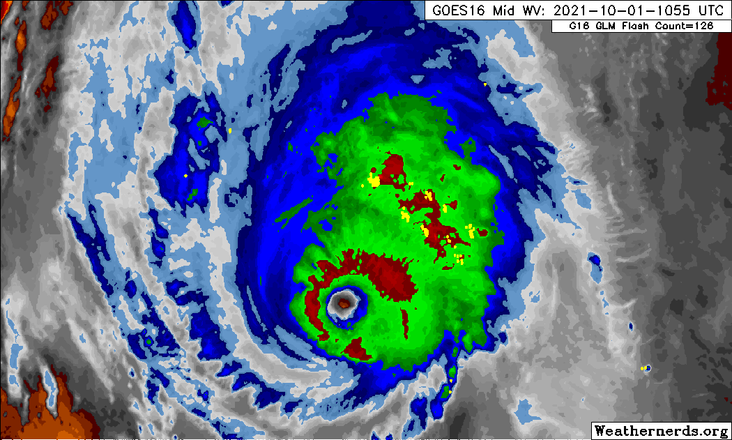
This loop illustrates bouts of westerly shear that have hindered full consolidation over the past few days. The core has consistently been a bit lopsided (diagram).
0 likes
CVW / MiamiensisWx / Shell Mound
The posts in this forum are NOT official forecasts and should not be used as such. They are just the opinion of the poster and may or may not be backed by sound meteorological data. They are NOT endorsed by any professional institution or STORM2K. For official information, please refer to products from the NHC and NWS.


Re: ATL: SAM - Hurricane - Discussion
The best Sam has looked in days. A fantastic storm for this far north this late in the year. Recon might find a 135 kt storm at this rate.

4 likes
Irene '11 Sandy '12 Hermine '16 5/15/2018 Derecho Fay '20 Isaias '20 Elsa '21 Henri '21 Ida '21
I am only a meteorology enthusiast who knows a decent amount about tropical cyclones. Look to the professional mets, the NHC, or your local weather office for the best information.
I am only a meteorology enthusiast who knows a decent amount about tropical cyclones. Look to the professional mets, the NHC, or your local weather office for the best information.
-
Hypercane_Kyle

- Category 5
- Posts: 3465
- Joined: Sat Mar 07, 2015 7:58 pm
- Location: Cape Canaveral, FL
Re: ATL: SAM - Hurricane - Discussion
RL3AO wrote:I'm mostly here to see if Sam can get to the impressive 50 ACE level. Current forecast has it getting close.
If it can stay 130 knots for the rest of the day, it has a real shot. Haven't seen an Atlantic power machine like this since Irma.
3 likes
My posts are my own personal opinion, defer to the National Hurricane Center (NHC) and other NOAA products for decision making during hurricane season.
Re: ATL: SAM - Hurricane - Discussion
Any idea why recon left earlier than expected (they weren't 'supposed to' leave until 15z, which is 30 minutes from now). Not complaining, just curious whether someone knows.
0 likes
-
Hypercane_Kyle
- Category 5
- Posts: 3465
- Joined: Sat Mar 07, 2015 7:58 pm
- Location: Cape Canaveral, FL
Re: ATL: SAM - Hurricane - Discussion
Shell Mound wrote:cycloneye wrote:https://twitter.com/philklotzbach/status/1443905715865669634
While Sam is impressive for its latitude, I doubt that the 147-kt FL winds were mixing efficiently. Neither Dvorak nor IR has supported ≥ 130 kt. Before others mention Dorian, I would like to point out that Dorian’s CDO and eye were far more symmetric than Sam’s has been over the past few days.
No offense, but your logic doesn't make any sense. Sam isn't nearly as strong as Dorian, that's confirmed by recon. So obviously, Sam isn't going to have nearly as symmetric of a CDO and eye. Sam doesn't need to be as strong as Dorian for the Dvorak estimates to be incorrect.
7 likes
My posts are my own personal opinion, defer to the National Hurricane Center (NHC) and other NOAA products for decision making during hurricane season.
Who is online
Users browsing this forum: No registered users and 37 guests