EPAC: FELICIA - Post-Tropical
Moderator: S2k Moderators
-
Kingarabian

- S2K Supporter

- Posts: 16367
- Joined: Sat Aug 08, 2009 3:06 am
- Location: Honolulu, Hawaii
Re: EPAC: FELICIA - Hurricane
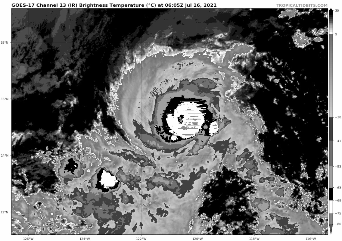
Eye is cooling but also very cold convection is wrapping around. So once/if the eye clears out, it would be a cat.4.
0 likes
RIP Kobe Bryant
-
Sciencerocks
- Category 5

- Posts: 10186
- Age: 40
- Joined: Thu Jul 06, 2017 1:51 am

-
Yellow Evan

- Professional-Met

- Posts: 16241
- Age: 27
- Joined: Fri Jul 15, 2011 12:48 pm
- Location: Henderson, Nevada/Honolulu, HI
- Contact:
Re: EPAC: FELICIA - Hurricane

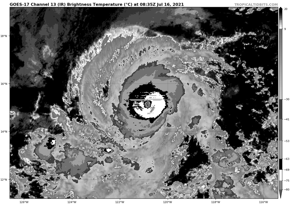
Becoming better organized. Eye will probably warm again in a few hours.
1 likes
-
Kingarabian
- S2K Supporter
- Posts: 16367
- Joined: Sat Aug 08, 2009 3:06 am
- Location: Honolulu, Hawaii
Re: EPAC: FELICIA - Hurricane
Eye warming a bit:

Very cold ring wrapping around:

Very cold ring wrapping around:
0 likes
RIP Kobe Bryant
-
Yellow Evan
- Professional-Met
- Posts: 16241
- Age: 27
- Joined: Fri Jul 15, 2011 12:48 pm
- Location: Henderson, Nevada/Honolulu, HI
- Contact:

-
Kingarabian
- S2K Supporter
- Posts: 16367
- Joined: Sat Aug 08, 2009 3:06 am
- Location: Honolulu, Hawaii
Re: EPAC: FELICIA - Hurricane
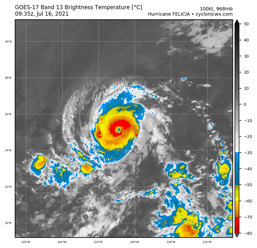
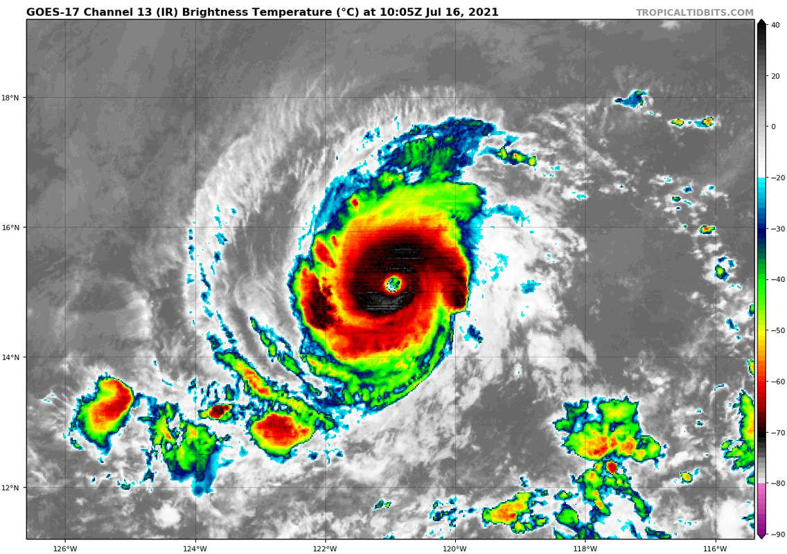
HURRICANE FELICIA ANALYSED POSITION : 15.2N 120.0W
ATCF IDENTIFIER : EP062021
LEAD CENTRAL MAXIMUM WIND
VERIFYING TIME TIME POSITION PRESSURE (MB) SPEED (KNOTS)
-------------- ---- -------- ------------- -------------
0000UTC 16.07.2021 0 15.2N 120.0W 966 76
1200UTC 16.07.2021 12 15.1N 121.6W 958 81
0000UTC 17.07.2021 24 14.7N 123.4W 966 66
1200UTC 17.07.2021 36 14.2N 124.9W 970 71
0000UTC 18.07.2021 48 14.2N 126.6W 976 58
1200UTC 18.07.2021 60 14.5N 128.4W 979 56
0000UTC 19.07.2021 72 14.7N 130.3W 981 60
1200UTC 19.07.2021 84 14.9N 132.2W 984 60
0000UTC 20.07.2021 96 15.0N 134.1W 986 55
1200UTC 20.07.2021 108 14.9N 135.9W 989 52
0000UTC 21.07.2021 120 14.7N 138.0W 992 51
1200UTC 21.07.2021 132 14.3N 140.2W 993 46
0000UTC 22.07.2021 144 14.0N 142.5W 997 47
0 likes
RIP Kobe Bryant

Re: EPAC: FELICIA - Hurricane
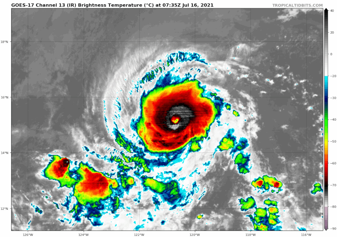
It's a small core, I think this is one of those systems Dvorak will have trouble keeping up with. Those small cores can shed millibars fast, and despite the eye not being fully clear and warm, I'd bet the pressure is dropping fairly quick with that convective signature. Wouldn't surprise me if she was already at 110-115kts.
0 likes
Solar Aquarian
Lunar Cancerian
 Sagittarian
Lunar Cancerian
-
Yellow Evan
- Professional-Met
- Posts: 16241
- Age: 27
- Joined: Fri Jul 15, 2011 12:48 pm
- Location: Henderson, Nevada/Honolulu, HI
- Contact:
Re: EPAC: FELICIA - Hurricane

Eyewall seems to be eroding a bit. May be the new burst of convection which is also causing it to cool.
0 likes
-
Yellow Evan
- Professional-Met
- Posts: 16241
- Age: 27
- Joined: Fri Jul 15, 2011 12:48 pm
- Location: Henderson, Nevada/Honolulu, HI
- Contact:

-
Yellow Evan
- Professional-Met
- Posts: 16241
- Age: 27
- Joined: Fri Jul 15, 2011 12:48 pm
- Location: Henderson, Nevada/Honolulu, HI
- Contact:
Re: EPAC: FELICIA - Hurricane
----- Current Analysis -----
Date : 16 JUL 2021 Time : 045031 UTC
Lat : 15:12:36 N Lon : 120:23:23 W
CI# /Pressure/ Vmax
5.4 / 963.4mb/ 99.6kt
Final T# Adj T# Raw T#
5.2 5.3 5.3
Estimated radius of max. wind based on IR : 5 km
Center Temp : -39.1C Cloud Region Temp : -62.7C
Scene Type : EYE
Date : 16 JUL 2021 Time : 045031 UTC
Lat : 15:12:36 N Lon : 120:23:23 W
CI# /Pressure/ Vmax
5.4 / 963.4mb/ 99.6kt
Final T# Adj T# Raw T#
5.2 5.3 5.3
Estimated radius of max. wind based on IR : 5 km
Center Temp : -39.1C Cloud Region Temp : -62.7C
Scene Type : EYE
0 likes
-
Yellow Evan
- Professional-Met
- Posts: 16241
- Age: 27
- Joined: Fri Jul 15, 2011 12:48 pm
- Location: Henderson, Nevada/Honolulu, HI
- Contact:

-
Yellow Evan
- Professional-Met
- Posts: 16241
- Age: 27
- Joined: Fri Jul 15, 2011 12:48 pm
- Location: Henderson, Nevada/Honolulu, HI
- Contact:
Re: EPAC: FELICIA - Hurricane
TXPZ25 KNES 160554
TCSENP
A. 06E (FELICIA)
B. 16/0530Z
C. 15.3N
D. 120.5W
E. ONE/GOES-W
F. T5.5/5.5
G. IR/EIR/SWIR
H. REMARKS...A MEDIUM GREY EYE THAT IS SURROUNDED BY WHITE AND EMBEDDED
IN BLACK COLD OVERCAST RESULTS IN A DT OF 5.5 WITH NO EYE ADJUSTMENT
MADE TO THE DT. THE MET AND PT AGREE WITH THE DT AND ARE ALSO EQUAL TO
5.5 BASED ON A RAPID DEVELOPMENT TREND OVER THE PAST 24 HOURS. THE FT
IS BASED ON THE DT.
I. ADDL POSITIONS
NIL
...SAMBUCCI
0 likes
-
Kingarabian
- S2K Supporter
- Posts: 16367
- Joined: Sat Aug 08, 2009 3:06 am
- Location: Honolulu, Hawaii
Re: EPAC: FELICIA - Hurricane
0 likes
RIP Kobe Bryant
Re: EPAC: FELICIA - Major Hurricane
EP, 06, 2021071606, , BEST, 0, 152N, 1206W, 100, 968, HU, 34, NEQ, 50, 40, 40, 50, 1012, 120, 15, 0, 0, E, 0, , 0, 0, FELICIA, D, 0, , 0, 0, 0, 0, genesis-num, 009,
EP, 06, 2021071606, , BEST, 0, 152N, 1206W, 100, 968, HU, 50, NEQ, 30, 30, 20, 30, 1012, 120, 15, 0, 0, E, 0, , 0, 0, FELICIA, D, 0, , 0, 0, 0, 0, genesis-num, 009,
EP, 06, 2021071606, , BEST, 0, 152N, 1206W, 100, 968, HU, 64, NEQ, 20, 10, 10, 20, 1012, 120, 15, 0, 0, E, 0, , 0, 0, FELICIA, D, 0, , 0, 0, 0, 0, genesis-num, 009,
2 likes
-
Kingarabian
- S2K Supporter
- Posts: 16367
- Joined: Sat Aug 08, 2009 3:06 am
- Location: Honolulu, Hawaii
Re: EPAC: FELICIA - Hurricane
Solid Dvorak presentation for the past few hours:
0 likes
RIP Kobe Bryant
-
Kingarabian
- S2K Supporter
- Posts: 16367
- Joined: Sat Aug 08, 2009 3:06 am
- Location: Honolulu, Hawaii
-
cycloneye

- Admin

- Posts: 149514
- Age: 69
- Joined: Thu Oct 10, 2002 10:54 am
- Location: San Juan, Puerto Rico
Re: EPAC: FELICIA - Hurricane
BULLETIN
Hurricane Felicia Advisory Number 9
NWS National Hurricane Center Miami FL EP062021
200 AM PDT Fri Jul 16 2021
...FELICIA BECOMES A MAJOR HURRICANE...
...FURTHER STRENGTHENING FORECASTED...
SUMMARY OF 200 AM PDT...0900 UTC...INFORMATION
----------------------------------------------
LOCATION...15.1N 121.0W
ABOUT 900 MI...1450 KM SW OF THE SOUTHERN TIP OF BAJA CALIFORNIA
MAXIMUM SUSTAINED WINDS...115 MPH...185 KM/H
PRESENT MOVEMENT...W OR 260 DEGREES AT 9 MPH...15 KM/H
MINIMUM CENTRAL PRESSURE...968 MB...28.59 INCHES
WATCHES AND WARNINGS
--------------------
There are no coastal watches or warnings in effect.
DISCUSSION AND OUTLOOK
----------------------
At 200 AM PDT (0900 UTC), the center of Hurricane Felicia was
located near latitude 15.1 North, longitude 121.0 West. Felicia is
moving toward the west near 9 mph (15 km/h). A general
west-southwest motion is expected over the next 24 hours with a
turn back to the west expected over the weekend.
Maximum sustained winds have increased to near 115 mph (185 km/h)
with higher gusts. Felicia is now category 3 hurricane on the
Saffir-Simpson Hurricane Wind Scale and additional strengthening is
forecast today. This will be followed by a very gradual weakening
trend through the end of the weekend.
Felicia is a small tropical cyclone, with hurricane-force winds
extending outward up to 25 miles (35 km) from the center and
tropical-storm-force winds extend outward up to 60 miles (95 km).
The estimated minimum central pressure is 968 mb (28.59 inches).
HAZARDS AFFECTING LAND
----------------------
None.
NEXT ADVISORY
-------------
Next complete advisory at 800 AM PDT.
$$
Forecaster Papin/Beven
Hurricane Felicia Discussion Number 9
NWS National Hurricane Center Miami FL EP062021
200 AM PDT Fri Jul 16 2021
Tiny Felicia has continued to intensify tonight. Earlier SSMIS
microwave imagery showed that the hurricane was maintaining a closed
circular eyewall and cloud-top temperatures surrounding the eye on
infrared satellite have continued to cool below -70 C. Scatterometer
data from an ASCAT-A pass at 0418 UTC also indicated the small size
of Felicia's wind field, with peak 34-kt wind radii only extending
roughly 50 nm from the center in the northern semicircle. Subjective
Dvorak estimates at 0600 UTC were both T5.5/102 kt from TAFB and SAB
while the latest UW-CIMSS ADT objective estimate was T5.4/100 kt. A
blend of these intensity estimates support a current intensity of
100 kt, making Felicia the first major hurricane in the East Pacific
basin this year.
Felicia now appears to be moving slightly south of due west with the
latest estimated motion at 260/8 kt. Now that the strongest
deep-layer ridging is positioned northwest of the hurricane, a
west-southwestward motion is expected to continue for the next day
or so. Afterwards, a narrow ridge axis shifts back north of Felicia,
and the cyclone is expected to resume a more due westward motion
between 24 to 72 hours. In the latter portion of the track forecast,
the hurricane will come under the influence of a stronger mid-level
ridge located north of Hawaii, resulting in another leftward turn by
the end of the forecast period. The latest track guidance remains in
good agreement for the majority of the forecast. The official NHC
forecast is a touch south of the previous track and lies between the
HCCA and TVCE consensus aids.
Additional short-term intensification is forecast while Felicia
remains in a favorable environment of low vertical wind shear
between 5-10 kt and warm sea-surface temperatures (SSTs) between
27-28 C. Thereafter, mid-level humidity values are forecasted by the
ECMWF-SHIPS guidance to drop below 50 percent as SSTs also gradually
decrease. However, both deep-layer (200-850 hPa) and mid-level
vertical wind shear are expected to remain light and easterly
through at least the next 72 hours. Light easterly shear in
combination with marginally warm SSTs are common environmental
factors associated with major hurricanes that develop annular
characteristics, and these storms are known to weaken at a slower
than typical rate. To account for this possibility, the intensity
forecast only shows very gradual weakening between 24 to 48 hours
which is above the majority of the intensity guidance but lies
closest to CTCI (COAMPS-TC). Afterwards, Felicia's weakening rate is
forecast to increase as SSTs cool further, and northwesterly
vertical-wind shear impinges on the cyclone by the end of the
forecast period. The latter portion of the intensity forecast is
closer to the mean of the intensity guidance and is near the HCCA
intensity consensus aid at 120 hours.
FORECAST POSITIONS AND MAX WINDS
INIT 16/0900Z 15.1N 121.0W 100 KT 115 MPH
12H 16/1800Z 14.9N 122.0W 110 KT 125 MPH
24H 17/0600Z 14.6N 123.4W 105 KT 120 MPH
36H 17/1800Z 14.5N 125.1W 100 KT 115 MPH
48H 18/0600Z 14.6N 126.8W 95 KT 110 MPH
60H 18/1800Z 14.7N 128.7W 85 KT 100 MPH
72H 19/0600Z 14.8N 130.5W 80 KT 90 MPH
96H 20/0600Z 14.6N 134.2W 65 KT 75 MPH
120H 21/0600Z 13.8N 137.6W 55 KT 65 MPH
$$
Forecaster Papin/Beven
1 likes
Visit the Caribbean-Central America Weather Thread where you can find at first post web cams,radars
and observations from Caribbean basin members Click Here
and observations from Caribbean basin members Click Here
-
Kingarabian
- S2K Supporter
- Posts: 16367
- Joined: Sat Aug 08, 2009 3:06 am
- Location: Honolulu, Hawaii
Re: EPAC: FELICIA - Hurricane
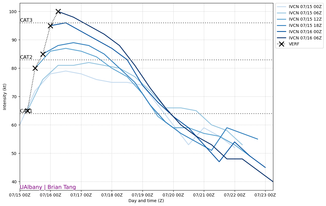
Felicia has been wrecking the intensity forecasts:
8 likes
RIP Kobe Bryant
-
Kingarabian
- S2K Supporter
- Posts: 16367
- Joined: Sat Aug 08, 2009 3:06 am
- Location: Honolulu, Hawaii
Re: EPAC: FELICIA - Hurricane
Rare to see the GFS initialize this bad.
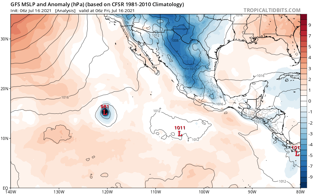
But the models in general have struggled so far with intensity. Probably will have implication down the line.
But the models in general have struggled so far with intensity. Probably will have implication down the line.
1 likes
RIP Kobe Bryant
-
Kingarabian
- S2K Supporter
- Posts: 16367
- Joined: Sat Aug 08, 2009 3:06 am
- Location: Honolulu, Hawaii
Who is online
Users browsing this forum: No registered users and 32 guests