Si Senor...HWRF creates max excitement but in reality it usually shoots blanksSFLcane wrote:Cuba still waiting for their Cat2 from Elsa. One day hwrf will get it right.
ATL: FRED - Models
Moderator: S2k Moderators
-
jlauderdal
- S2K Supporter

- Posts: 7240
- Joined: Wed May 19, 2004 5:46 am
- Location: NE Fort Lauderdale
- Contact:
Re: RE: Re: ATL: SIX - Models
2 likes
-
jlauderdal
- S2K Supporter
- Posts: 7240
- Joined: Wed May 19, 2004 5:46 am
- Location: NE Fort Lauderdale
- Contact:
Re: RE: Re: ATL: SIX - Models
Well the 2021 season is young but likely the hwrf isnt going to deliverAutoPenalti wrote:sucks that after excelling in 2020, the hwrf is likely about to be the donkey of 2021
1 likes

Re: ATL: SIX - Models
AutoPenalti wrote:sucks that after excelling in 2020, the hwrf is likely about to be the donkey of 2021
To be fair, a high end TS is a reasonable upper limit for intensity while in the Caribbean. Not sure about intensity after the Greater Antilles because so much depends on exactly where it tracks and where the TUTT will be by then.
1 likes
Irene '11 Sandy '12 Hermine '16 5/15/2018 Derecho Fay '20 Isaias '20 Elsa '21 Henri '21 Ida '21
I am only a meteorology enthusiast who knows a decent amount about tropical cyclones. Look to the professional mets, the NHC, or your local weather office for the best information.
I am only a meteorology enthusiast who knows a decent amount about tropical cyclones. Look to the professional mets, the NHC, or your local weather office for the best information.
-
hurricane2025
- Category 1

- Posts: 254
- Joined: Thu Apr 08, 2021 10:36 am
Re: ATL: SIX - Models
I say cat 1 but I think the one in 10 days will be a major problem
Last edited by hurricane2025 on Mon Aug 09, 2021 9:03 pm, edited 1 time in total.
1 likes

Re: ATL: SIX - Models
AlphaToOmega wrote:The HWRF strengthens Potential Tropical Cyclone 06L into an 85-knot 797 mb hurricane. Storms in this area are very sensitive to initial conditions, for a subtle change in trajectory could mean the difference between dissipation over Hispaniola and rapid intensification over the warm waters of the Gulf of Mexico.
Lol
5 likes
-
ScottNAtlanta

- Category 5

- Posts: 2535
- Joined: Sat May 25, 2013 3:11 pm
- Location: Atlanta, GA
Re: ATL: SIX - Models
Steve wrote:AlphaToOmega wrote:The HWRF strengthens Potential Tropical Cyclone 06L into an 85-knot 797 mb hurricane. Storms in this area are very sensitive to initial conditions, for a subtle change in trajectory could mean the difference between dissipation over Hispaniola and rapid intensification over the warm waters of the Gulf of Mexico.
Lol
I think that would be WAY under performing...

3 likes
The posts in this forum are NOT official forecast and should not be used as such. They are just the opinion of the poster and may or may not be backed by sound meteorological data. They are NOT endorsed by any professional institution or storm2k.org. For official information, please refer to the NHC and NWS products.
-
tropicwatch

- Category 5
- Posts: 3426
- Age: 62
- Joined: Sat Jun 02, 2007 10:01 am
- Location: The Villages, Florida
- Contact:
Re: ATL: SIX - Models
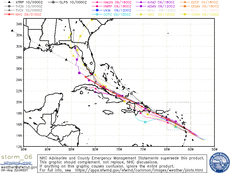
TVCN moving back over the south Florida peninsula is kind of interesting. I think NHC will give it one or two more runs to see if it verifies.
0 likes
Tropicwatch
Agnes 72', Eloise 75, Elena 85', Kate 85', Charley 86', Florence 88', Beryl 94', Dean 95', Erin 95', Opal 95', Earl 98', Georges 98', Ivan 2004', Arlene 2005', Dennis 2005', Ida 2009' Debby 2012' Irma 2017' Michael 2018'
Agnes 72', Eloise 75, Elena 85', Kate 85', Charley 86', Florence 88', Beryl 94', Dean 95', Erin 95', Opal 95', Earl 98', Georges 98', Ivan 2004', Arlene 2005', Dennis 2005', Ida 2009' Debby 2012' Irma 2017' Michael 2018'
-
SFLcane

- S2K Supporter
- Posts: 10281
- Age: 48
- Joined: Sat Jun 05, 2010 1:44 pm
- Location: Lake Worth Florida
Re: ATL: SIX - Models
It seems to be a weakness in the ridge around the keys the models are starting to hint at.
0 likes

Re: ATL: SIX - Models
Steve wrote:AlphaToOmega wrote:The HWRF strengthens Potential Tropical Cyclone 06L into an 85-knot 797 mb hurricane. Storms in this area are very sensitive to initial conditions, for a subtle change in trajectory could mean the difference between dissipation over Hispaniola and rapid intensification over the warm waters of the Gulf of Mexico.
Lol
That sir, simply crosses the line. When it comes to "chasing" I've just learned to say "no mas" the moment surface pressures drop below 825mb
3 likes
Andy D
(For official information, please refer to the NHC and NWS products.)
(For official information, please refer to the NHC and NWS products.)
-
AtlanticWind

- S2K Supporter
- Posts: 1898
- Age: 67
- Joined: Sun Aug 08, 2004 9:57 pm
- Location: Plantation,Fla
-
SouthFLTropics

- Category 5
- Posts: 4258
- Age: 50
- Joined: Thu Aug 14, 2003 8:04 am
- Location: Port St. Lucie, Florida
Re: ATL: SIX - Models
Looks like a decent jump in intensity for the 00z GFS.
0 likes
Fourth Generation Florida Native
Personal Storm History: David 79, Andrew 92, Erin 95, Floyd 99, Irene 99, Frances 04, Jeanne 04, Wilma 05, Matthew 16, Irma 17, Ian 22, Nicole 22, Milton 24
Personal Storm History: David 79, Andrew 92, Erin 95, Floyd 99, Irene 99, Frances 04, Jeanne 04, Wilma 05, Matthew 16, Irma 17, Ian 22, Nicole 22, Milton 24
-
AtlanticWind
- S2K Supporter
- Posts: 1898
- Age: 67
- Joined: Sun Aug 08, 2004 9:57 pm
- Location: Plantation,Fla
-
lsuhurricane
- Category 1
- Posts: 270
- Joined: Tue Aug 15, 2017 2:53 pm
Re: ATL: SIX - Models
Very erratic movement once in the gulf for this GFS run. Steering clearly driven by competing factors
0 likes
-
ElectricStorm

- Category 5
- Posts: 5148
- Age: 25
- Joined: Tue Aug 13, 2019 11:23 pm
- Location: Norman, OK
Re: ATL: SIX - Models
983mb into the big bend on 0z GFS
0 likes
B.S Meteorology, University of Oklahoma '25
Please refer to the NHC, NWS, or SPC for official information.
Please refer to the NHC, NWS, or SPC for official information.
-
Hurricaneman

- Category 5
- Posts: 7404
- Age: 45
- Joined: Tue Aug 31, 2004 3:24 pm
- Location: central florida
Re: ATL: SIX - Models
SouthFLTropics wrote:Looks like a decent jump in intensity for the 00z GFS.
Yep, has a near cat2 hurricane near Cedar Key, it’s 6 1/2 days away so it could change, if this goes north of Hispaniola and through the Florida Straits it could conceivably become even stronger than the GFS depicts
1 likes
-
AxaltaRacing24
- Category 5
- Posts: 1774
- Age: 25
- Joined: Wed Jul 27, 2016 11:14 am
- Location: Jupiter, FL
Re: ATL: SIX - Models
Hurricaneman wrote:SouthFLTropics wrote:Looks like a decent jump in intensity for the 00z GFS.
Yep, has a near cat2 hurricane near Cedar Key, it’s 6 1/2 days away so it could change, if this goes north of Hispaniola and through the Florida Straits it could conceivably become even stronger than the GFS depicts
Yeah, this isn't just an early season slop if it misses some land. Conditions are clearly favorable enough for somebody to get at least a cat 1.
0 likes
-
Category5Kaiju

- Category 5
- Posts: 4338
- Joined: Thu Dec 24, 2020 12:45 pm
- Location: Seattle during the summer, Phoenix during the winter
ATL: SIX - Potential Tropical Cyclone - Discussion
GFS latest has it as a 983 mbar storm hitting the Panhandle on August 16
1 likes
Unless explicitly stated, all information in my posts is based on my own opinions and observations. Tropical storms and hurricanes can be extremely dangerous. Refer to an accredited weather research agency or meteorologist if you need to make serious decisions regarding an approaching storm.

Re: ATL: SIX - Models
A month early, but reminiscent of Irma track-wise.
0 likes
Andrew (1992), Irene (1999), Frances (2004), Katrina (2005), Wilma (2005), Fay (2008), Irma (2017), Eta (2020), Ian (2022)
Re: ATL: SIX - Models
Yeah, well .. the 0Z GFS says "Good times" for the Keys over the next couple weeks
0 likes
Who is online
Users browsing this forum: No registered users and 49 guests