
https://twitter.com/JimCantore/status/1431697034843762691
ATL: IDA - Remnants - Discussion
Moderator: S2k Moderators
-
FLpanhandle91

- Category 5

- Posts: 1039
- Age: 34
- Joined: Mon Sep 13, 2010 3:50 pm
- Location: Fort Walton Beach, FL
Re: ATL: IDA - Hurricane - Discussion
Ubuntwo wrote:InfernoFlameCat wrote:essentially it was. 100 knots is cat 3 right?DestinHurricane wrote:Zeta wasn't major when it was over NOLA.
Zeta made landfall in an uninhabited marsh. The city of New Orleans itself received low-end category 1 winds.
Zeta was also moving almost 30mph at landfall.
0 likes

Re: ATL: IDA - Hurricane - Discussion
Seeing some lightning in the eyewall again, probably getting stronger

1 likes
Very useful information on the Dvorak Technique --
https://severe.worldweather.wmo.int/TCF ... kBeven.pdf
https://severe.worldweather.wmo.int/TCF ... kBeven.pdf

Re: ATL: IDA - Hurricane - Discussion
SconnieCane wrote:MBryant wrote:I was just looking at past hurricanes similar in intensity and approach to the forecast for IDA. Betsy 1965 looks awfully close.
Closest analog at this point.
Yes Betsy seems like a good analogy, we are gonna ride her out unless she bombs out. Relative nearby in a well built house above flood elevation if we need to leave Sunday.
Surprised we are seeing more post from Aric and GCANE. I know Wxman 57 is really busy.
4 likes
The following post is NOT an official forecast and should not be used as such. It is just the opinion of the poster and may or may not be backed by sound meteorological data. It is NOT endorsed by any professional institution including storm2k.org For Official Information please refer to the NHC and NWS products.
-
Category5Kaiju

- Category 5
- Posts: 4334
- Joined: Thu Dec 24, 2020 12:45 pm
- Location: Seattle and Phoenix
Re: ATL: IDA - Hurricane - Discussion
Deep Layer Shear:

Mid Level Shear:
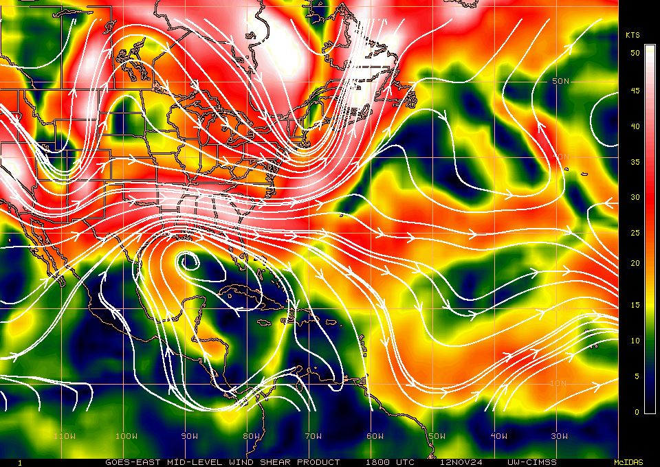
Humidity:
http://tropic.ssec.wisc.edu/real-time/sal/g16split/movies/goes16split.html
I just cannot find a reason why Ida would not be able to reach whatever potential it has, based on these three factors being favorable, it looks like a system that can really take advantage of the Loop Current otherwise. Unless there's something else I am missing.
Mid Level Shear:
Humidity:
http://tropic.ssec.wisc.edu/real-time/sal/g16split/movies/goes16split.html
I just cannot find a reason why Ida would not be able to reach whatever potential it has, based on these three factors being favorable, it looks like a system that can really take advantage of the Loop Current otherwise. Unless there's something else I am missing.
0 likes
Unless explicitly stated, all info in my posts is based on my own opinions and observations. Tropical storms and hurricanes can be extremely dangerous. Refer to an accredited weather research agency or meteorologist if you need to make serious decisions regarding an approaching storm.
Re: ATL: IDA - Hurricane - Discussion
Lightning visible

6 likes
Very useful information on the Dvorak Technique --
https://severe.worldweather.wmo.int/TCF ... kBeven.pdf
https://severe.worldweather.wmo.int/TCF ... kBeven.pdf
-
DestinHurricane

- Category 4

- Posts: 935
- Joined: Tue May 01, 2018 8:05 am
- Location: New York, NY
Re: ATL: IDA - Hurricane - Discussion
tailgater wrote:SconnieCane wrote:MBryant wrote:I was just looking at past hurricanes similar in intensity and approach to the forecast for IDA. Betsy 1965 looks awfully close.
Closest analog at this point.
Yes Betsy seems like a good analogy, we are gonna ride her out unless she bombs out. Relative nearby in a well built house above flood elevation if we need to leave Sunday.
Surprised we are seeing more post from Aric and GCANE. I know Wxman 57 is really busy.
It is bombing out right now, as we speak. Be prepared for a high end cat 4 landfall.
I don't know where GCANE is. Aric is a chaser and he mostly just talks on one of the tropics Discords now.
4 likes
Michael 2018
-
Hypercane_Kyle

- Category 5
- Posts: 3465
- Joined: Sat Mar 07, 2015 7:58 pm
- Location: Cape Canaveral, FL
Re: ATL: IDA - Hurricane - Discussion
Best track up to 90 knots (105 mph)
0 likes
My posts are my own personal opinion, defer to the National Hurricane Center (NHC) and other NOAA products for decision making during hurricane season.
-
FLpanhandle91
- Category 5
- Posts: 1039
- Age: 34
- Joined: Mon Sep 13, 2010 3:50 pm
- Location: Fort Walton Beach, FL
Re: ATL: IDA - Hurricane - Discussion
CDO looks vastly improved. Still a bit warm, but the core structure of Ida is rapidly improving.
1 likes
ATL: IDA - Hurricane - Discussion
Deluge from an outer band here...
Thunder...Not much wind...
The FIST...
Power flickers...
Thunder...Not much wind...
The FIST...
Power flickers...
Last edited by Sanibel on Sat Aug 28, 2021 2:40 pm, edited 2 times in total.
3 likes
Re: ATL: IDA - Hurricane - Discussion
Ubuntwo wrote:InfernoFlameCat wrote:essentially it was. 100 knots is cat 3 right?DestinHurricane wrote:Zeta wasn't major when it was over NOLA.
Zeta made landfall in an uninhabited marsh. The city of New Orleans itself received low-end category 1 winds.
I kept hearing that and believed it. But Zeta diminished from 90 to 85 knots and Bestsy diminished from 115 to 95 to 65 after going onshore. The lowlands may not hinder circulation as long as the eye is over water, but it appears it will diminish once the eye is on land, even low land.
0 likes
Living at the intersection of Rita and Humberto and Ike and Harvey and Laura and Delta!
This post is NOT an official forecast and should not be used as such. It is just my opinion and may or may not be backed by sound meteorological products.
This post is NOT an official forecast and should not be used as such. It is just my opinion and may or may not be backed by sound meteorological products.
-
PavelGaborik
- Tropical Depression

- Posts: 81
- Joined: Thu Oct 06, 2016 11:13 pm
Re: ATL: IDA - Hurricane - Discussion
Genuinely surprised by the lack of cold cloud tops. She's definitely improving but it seems she hasn't undergone RI yet, let's hope that continues.
0 likes
-
gatorcane

- S2K Supporter

- Posts: 23708
- Age: 48
- Joined: Sun Mar 13, 2005 3:54 pm
- Location: Boca Raton, FL
Re: ATL: IDA - Hurricane - Discussion
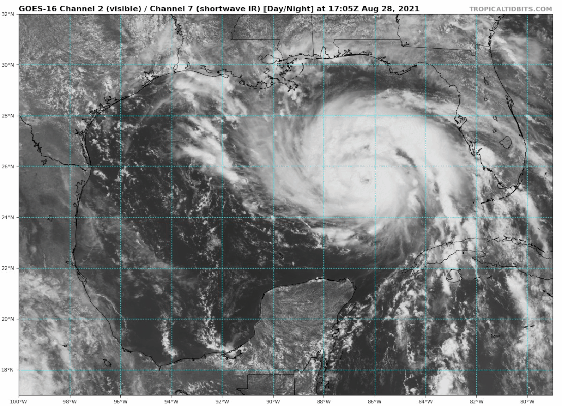
gatorcane wrote::eek:
Looks like a major hurricane to me:
https://i.postimg.cc/QCc2CYjY/goes16-vis-swir-gom.gif
Also looks east of the track, watch out NOLA
0 likes
-
Hypercane_Kyle
- Category 5
- Posts: 3465
- Joined: Sat Mar 07, 2015 7:58 pm
- Location: Cape Canaveral, FL
Re: ATL: IDA - Hurricane - Discussion
PavelGaborik wrote:Genuinely surprised by the lack of cold cloud tops. She's definitely improving but it seems she hasn't undergone RI yet, let's hope that continues.
Ida is going past a cooler pool of water and has yet to reach the loop current, thus the warmer cloud tops.
1 likes
My posts are my own personal opinion, defer to the National Hurricane Center (NHC) and other NOAA products for decision making during hurricane season.
ATL: IDA - Hurricane - Discussion
We haven't seen this play out from a pass over the Loop Current yet...
1 likes
-
AlabamaDave
- Tropical Storm

- Posts: 169
- Joined: Wed Aug 11, 2004 6:44 pm
Re: ATL: IDA - Hurricane - Discussion
gatorcane wrote::eek:
Looks like a major hurricane to me:
https://i.postimg.cc/QCc2CYjY/goes16-vis-swir-gom.gif
I don't like the trajectory of the eye right now... I'm increasingly worried that this storm will get closer to New Orleans than anticipated.
1 likes

Re: ATL: IDA - Hurricane - Discussion
Sanibel wrote:Deluge from an outer band here...
Thunder...Not much wind...
We got a heavy rain band in Key West around 2am this morning just in time for my drive home, gusts over 40mph(officially at the airport) though likely a bit higher in isolated spots with microbursts that seemed to be occuring, lightning and very heavy rain. I'm very glad Ida was not any closer.
1 likes
-
karenfromheaven

- Tropical Storm
- Posts: 171
- Age: 71
- Joined: Thu Sep 09, 2004 4:45 pm
- Location: North Naples, FL
Re: ATL: IDA - Hurricane - Discussion
Sanibel wrote:Deluge from an outer band here...
Thunder...Not much wind...
The FIST...
Power flickers...
Just inland from you, got slammed with it earlier. Burst of heavy rain and lightning.
0 likes

Re: ATL: IDA - Hurricane - Discussion
Am looking at the IR and not sure whether mid level dry air or simply UL shear but something is pressing up and against it's south quad. Looks to me more then light southerly shear given the moisture delineation feeding in from the southwest. Given Ida's forward motion, it may be a mute point so long as it's not drier air being entrained into the circulation
1 likes
Andy D
(For official information, please refer to the NHC and NWS products.)
(For official information, please refer to the NHC and NWS products.)
Who is online
Users browsing this forum: No registered users and 31 guests