ATL: IDA - Remnants - Discussion

Moderator: S2k Moderators

Message
Author
storminabox
Category 1
Category 1
Posts: 263
Joined: Sun Jul 09, 2017 10:50 pm

Re: ATL: IDA - Hurricane - Discussion

#2341 Postby storminabox » Sat Aug 28, 2021 3:04 pm

GCANE wrote:Haven't seen any high rain rates.
CAPE and Theta-E is borderline to minimal thru the GOM, which the models have been correctly advertising for many days now.

Chances of RI are somewhat minimal IMHO.


Then why were many of them advertising RI?
2 likes   

User avatar
GCANE
S2K Supporter
S2K Supporter
Posts: 11497
Joined: Mon Oct 22, 2007 8:03 am

Re: ATL: IDA - Hurricane - Discussion

#2342 Postby GCANE » Sat Aug 28, 2021 3:04 pm

Shell Mound wrote:
PavelGaborik wrote:Genuinely surprised by the lack of cold cloud tops. She's definitely improving but it seems she hasn't undergone RI yet, let's hope that continues.

GCANE's observations suggest ML dry air is the culprit. Am I correct?


There is a big slot of ML Dry Air to the SW of Ida
Looks like the outflow is having a tough time with it.


Image
7 likes   

User avatar
Category5Kaiju
Category 5
Category 5
Posts: 4097
Joined: Thu Dec 24, 2020 12:45 pm
Location: Seattle

Re: ATL: IDA - Hurricane - Discussion

#2343 Postby Category5Kaiju » Sat Aug 28, 2021 3:05 pm

1 likes   
Unless explicitly stated, all info in my posts is based on my own opinions and observations. Tropical storms and hurricanes can be extremely dangerous. Do not think you can beat Mother Nature. Refer to an accredited weather research agency or meteorologist if you need to make serious decisions regarding an approaching storm.

grapealcoholic
Category 2
Category 2
Posts: 684
Joined: Tue Aug 10, 2021 3:26 pm

Re: ATL: IDA - Hurricane - Discussion

#2344 Postby grapealcoholic » Sat Aug 28, 2021 3:06 pm

CAPE unfortunately no longer matters, we're past that stage of the storm. Energy is being taken right off the warm surface waters now.
3 likes   

User avatar
Highteeld
Category 5
Category 5
Posts: 2139
Age: 41
Joined: Tue Jan 30, 2018 9:10 pm
Location: Chicago

Re: ATL: IDA - Hurricane - Discussion

#2345 Postby Highteeld » Sat Aug 28, 2021 3:07 pm

Here we go, clearing again. Smaller eye apparent

Image
3 likes   
Very useful information on the Dvorak Technique --

https://severe.worldweather.wmo.int/TCF ... kBeven.pdf

User avatar
Hypercane_Kyle
Category 5
Category 5
Posts: 3352
Joined: Sat Mar 07, 2015 7:58 pm
Location: Cape Canaveral, FL

Re: ATL: IDA - Hurricane - Discussion

#2346 Postby Hypercane_Kyle » Sat Aug 28, 2021 3:07 pm

GCANE wrote:
Shell Mound wrote:
PavelGaborik wrote:Genuinely surprised by the lack of cold cloud tops. She's definitely improving but it seems she hasn't undergone RI yet, let's hope that continues.

GCANE's observations suggest ML dry air is the culprit. Am I correct?


There is a big slot of ML Dry Air to the SW of Ida
Looks like the outflow is having a tough time with it.


[url]https://i.postimg.cc/rw2Kct95/99L1.png [/url]


No, I don't think this is the case. There does appear to be some mid-level flow that's causing a slight restriction to the inflow on the southern side, but if there was dry air, we'd be seeing more in the way of thunderstorm collapsing with outflow boundaries. Satellite does not show this. The likely culprit was Ida traveling over low OHC. Now about to enter the loop current, so the next 6-8 hours we will likely see intensification.
Last edited by Hypercane_Kyle on Sat Aug 28, 2021 3:08 pm, edited 1 time in total.
4 likes   
My posts are my own personal opinion, defer to the National Hurricane Center (NHC) and other NOAA products for decision making during hurricane season.

bluespiderfl
S2K Supporter
S2K Supporter
Posts: 10
Age: 55
Joined: Mon Oct 03, 2016 8:21 pm

Re: ATL: IDA - Hurricane - Discussion

#2347 Postby bluespiderfl » Sat Aug 28, 2021 3:08 pm

gatorcane wrote:
Shell Mound wrote:
Clearcloudz wrote:New Orleans I hope you see what I see. :eek: :eek: :eek: :eek:

https://i.imgur.com/JWgEL55.jpg

While this is still a very serious event, its wind field is smaller than either Katrina's or Betsy's, and current cloud tops do not suggest ERI. Even if it passes closer to NOLA, the surge and wind should be more confined than in either 1965 or 2005. As of now I think this will be somewhat less severe than Betsy in NOLA, though areas to the immediately southwest, closer to the coast, may be devastated. The current rate of deepening may be enough to support a high-end Category 3 at LF, but I am becoming a little more skeptical about a Category 4 or stronger. It will be severe, but perhaps not as severe as people think, certainly not over a wide area. But locally it will be bad.


Why wasn’t NOLA evacuated again? I heard because there was not enough time?


Because most of Southern LA especially in that NOLO area and i10 is all bridges.. Mandatory evacuation would even further congest that area and engaged even more people as they could possibly be stuck on the roads/bridges during LF.
1 likes   

User avatar
Iceresistance
Category 5
Category 5
Posts: 9288
Age: 21
Joined: Sat Oct 10, 2020 9:45 am
Location: Tecumseh, OK/Norman, OK

Re: ATL: IDA - Hurricane - Discussion

#2348 Postby Iceresistance » Sat Aug 28, 2021 3:08 pm

We got liftoff!

NOAA2 Mission #10 into IDA
Type: Unknown | Status: In Progress
1 likes   
Bill 2015 & Beta 2020

Winter 2020-2021 :cold:

All observations are in Tecumseh, OK unless otherwise noted.

Winter posts are focused mainly for Oklahoma & Texas.

Take any of my forecasts with a grain of salt, refer to the NWS, SPC, and NHC for official information

Never say Never with weather! Because ANYTHING is possible!

User avatar
johngaltfla
Category 5
Category 5
Posts: 2069
Joined: Sun Jul 10, 2005 9:17 pm
Location: Sarasota County, FL
Contact:

Re: ATL: IDA - Hurricane - Discussion

#2349 Postby johngaltfla » Sat Aug 28, 2021 3:09 pm


Cantore is spot on. And powerful storms tend to create some of their own steering currents usually more poleward.
0 likes   

grapealcoholic
Category 2
Category 2
Posts: 684
Joined: Tue Aug 10, 2021 3:26 pm

Re: ATL: IDA - Hurricane - Discussion

#2350 Postby grapealcoholic » Sat Aug 28, 2021 3:09 pm

Should find a major with contracted RMW.
0 likes   

User avatar
GCANE
S2K Supporter
S2K Supporter
Posts: 11497
Joined: Mon Oct 22, 2007 8:03 am

Re: ATL: IDA - Hurricane - Discussion

#2351 Postby GCANE » Sat Aug 28, 2021 3:09 pm

storminabox wrote:
GCANE wrote:Haven't seen any high rain rates.
CAPE and Theta-E is borderline to minimal thru the GOM, which the models have been correctly advertising for many days now.

Chances of RI are somewhat minimal IMHO.


Then why were many of them advertising RI?


I think they got excited about it going over the Loop Current and the big ARWB it would be in.
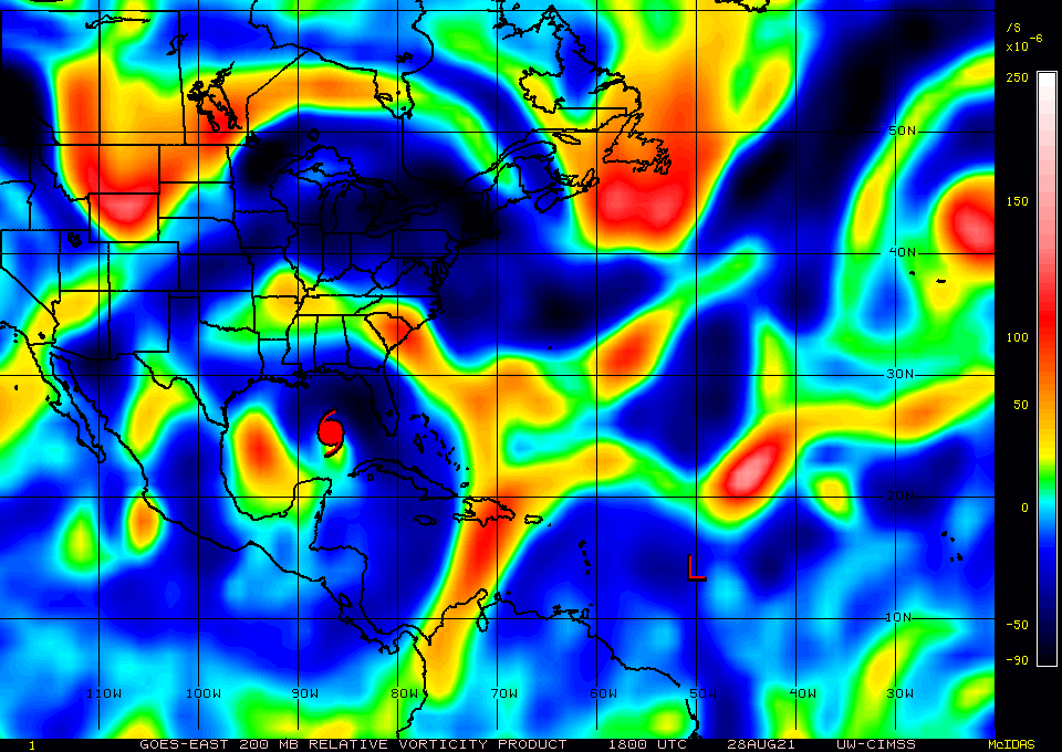
A good snap-shot of the ARWB is to look at 200 mb vort.
The models were depicting a solid PV ring and I mentioned this a few times in the past.
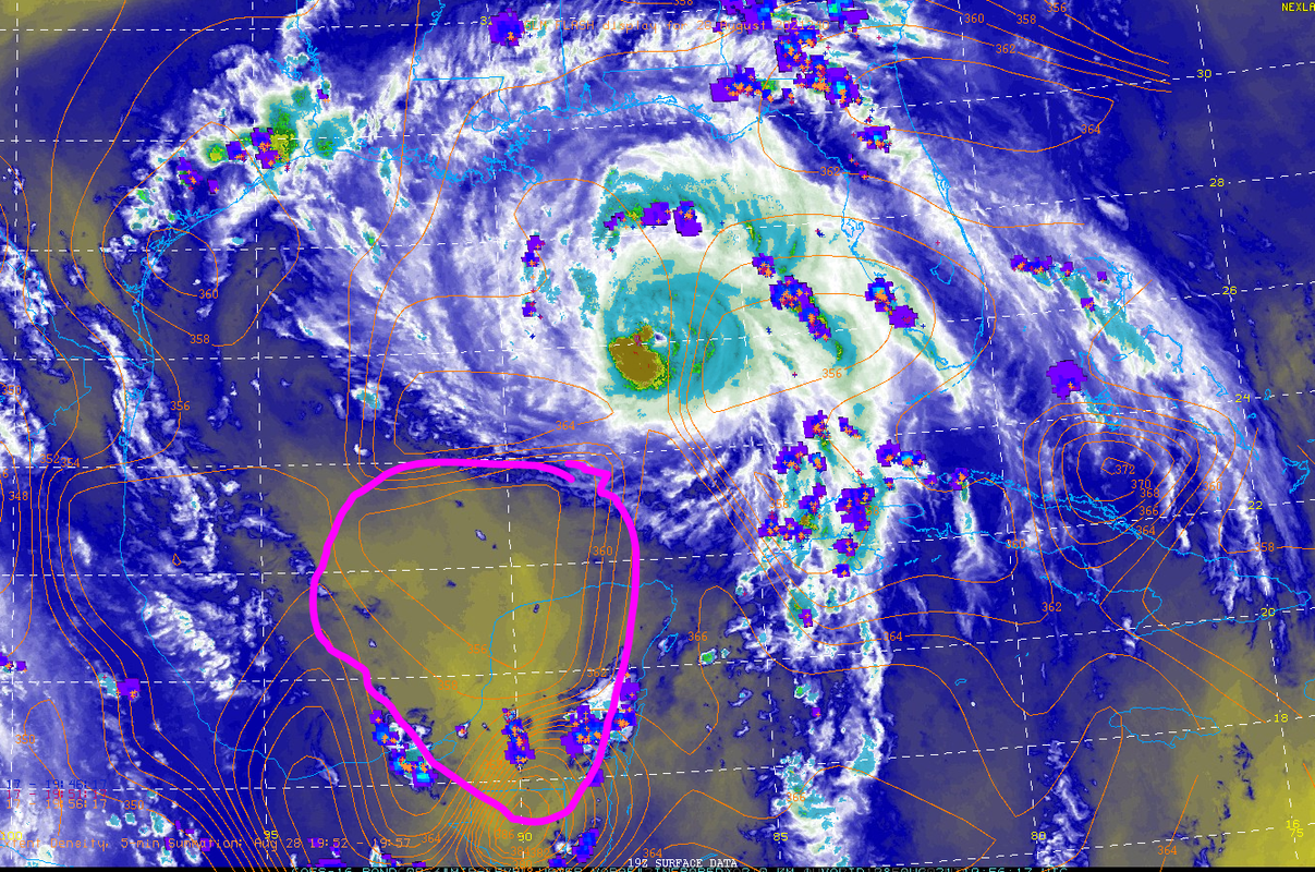
Even Levi showed this last night.
Currently, its not looking as good as what the forecasts were showing.


Image
2 likes   

Shell Mound
Category 5
Category 5
Posts: 2434
Age: 32
Joined: Thu Sep 07, 2017 3:39 pm
Location: St. Petersburg, FL → Scandinavia

Re: ATL: IDA - Hurricane - Discussion

#2352 Postby Shell Mound » Sat Aug 28, 2021 3:09 pm

In the end Ida may not deepen or expand enough to justify an evacuation. The somewhat small wind field would not generate widespread surge, the NHC forecasts rapid weakening over land, and the rather anemic convection may not allow FL winds to mix/transfer efficiently down to the surface. I think Ida is likely to be at most a strong Cat 3 at LF, and I may be a little generous. It will be bad locally, but perhaps manageable in NOLA, even with the eastern eyewall making a direct hit. We shall see. Everyone should be prepared for the worst.
0 likes   
CVW / MiamiensisWx / Shell Mound
The posts in this forum are NOT official forecasts and should not be used as such. They are just the opinion of the poster and may or may not be backed by sound meteorological data. They are NOT endorsed by any professional institution or STORM2K. For official information, please refer to products from the NHC and NWS.

User avatar
SEASON_CANCELED
Category 3
Category 3
Posts: 887
Joined: Mon Jul 06, 2009 5:17 am
Location: 8 Bit Charlie Sheen

Re: ATL: IDA - Hurricane - Discussion

#2353 Postby SEASON_CANCELED » Sat Aug 28, 2021 3:10 pm

Shell Mound wrote:In the end Ida may not deepen or expand enough to justify an evacuation. The somewhat small wind field would not generate widespread surge, the NHC forecasts rapid weakening over land, and the rather anemic convection may not allow FL winds to mix/transfer efficiently down to the surface. I think Ida is likely to be at most a strong Cat 3 at LF, and I may be a little generous. It will be bad locally, but perhaps manageable in NOLA, even with the eastern eyewall making a direct hit. We shall see. Everyone should be prepared for the worst.


Optimistic outcome

Lets hope you are right.

We could also wake up tomorrow to a category 5 storm about to make landfall.
0 likes   
i am a big stupid ugly moron with an ugly face and a big butt and my butt stinks and i like to kiss my own butt

User avatar
ElectricStorm
Category 5
Category 5
Posts: 5044
Age: 24
Joined: Tue Aug 13, 2019 11:23 pm
Location: Skiatook, OK / Norman, OK

Re: ATL: IDA - Hurricane - Discussion

#2354 Postby ElectricStorm » Sat Aug 28, 2021 3:10 pm

The relatively warm cloud tops might be due to daytime heating, and the lower OHC. I'm guessing Ida is going to intensify the fastest tonight when it's over the hottest part of the Loop Current. Will likely be a major by tonight. I'm not really seeing any dry air affecting it right now
5 likes   
B.S Meteorology, University of Oklahoma '25

Please refer to the NHC, NWS, or SPC for official information.

PavelGaborik
Tropical Depression
Tropical Depression
Posts: 81
Joined: Thu Oct 06, 2016 11:13 pm

Re: ATL: IDA - Hurricane - Discussion

#2355 Postby PavelGaborik » Sat Aug 28, 2021 3:14 pm

SEASON_CANCELED wrote:
Shell Mound wrote:In the end Ida may not deepen or expand enough to justify an evacuation. The somewhat small wind field would not generate widespread surge, the NHC forecasts rapid weakening over land, and the rather anemic convection may not allow FL winds to mix/transfer efficiently down to the surface. I think Ida is likely to be at most a strong Cat 3 at LF, and I may be a little generous. It will be bad locally, but perhaps manageable in NOLA, even with the eastern eyewall making a direct hit. We shall see. Everyone should be prepared for the worst.


Optimistic outcome

Lets hope you are right.

We could also wake up tomorrow to a category 5 storm about to make landfall.


I think the cat 5 window is just about closed at this point.
4 likes   

User avatar
ElectricStorm
Category 5
Category 5
Posts: 5044
Age: 24
Joined: Tue Aug 13, 2019 11:23 pm
Location: Skiatook, OK / Norman, OK

Re: ATL: IDA - Hurricane - Discussion

#2356 Postby ElectricStorm » Sat Aug 28, 2021 3:14 pm

NOAA2 plane is in the air the long recon wait is nearly over
1 likes   
B.S Meteorology, University of Oklahoma '25

Please refer to the NHC, NWS, or SPC for official information.

bob rulz
Category 5
Category 5
Posts: 1704
Age: 35
Joined: Sat Jan 28, 2006 7:30 pm
Location: Salt Lake City, Utah

Re: ATL: IDA - Hurricane - Discussion

#2357 Postby bob rulz » Sat Aug 28, 2021 3:15 pm

I don't think we can make any conclusions on how strong it will be until it crosses over the deepest part of the Loop Current. I do agree that cat 5 is unlikely at this point, but cat 4 is still very much within the realm of possibility.
Last edited by bob rulz on Sat Aug 28, 2021 3:15 pm, edited 1 time in total.
5 likes   

User avatar
GCANE
S2K Supporter
S2K Supporter
Posts: 11497
Joined: Mon Oct 22, 2007 8:03 am

Re: ATL: IDA - Hurricane - Discussion

#2358 Postby GCANE » Sat Aug 28, 2021 3:15 pm

Going to wait to see how the eyewall looks after sunset on IR.
Right now, cloud tops on the eyewall are pretty warm.
1 likes   

User avatar
Hypercane_Kyle
Category 5
Category 5
Posts: 3352
Joined: Sat Mar 07, 2015 7:58 pm
Location: Cape Canaveral, FL

Re: ATL: IDA - Hurricane - Discussion

#2359 Postby Hypercane_Kyle » Sat Aug 28, 2021 3:15 pm

Shell Mound wrote:In the end Ida may not deepen or expand enough to justify an evacuation. The somewhat small wind field would not generate widespread surge, the NHC forecasts rapid weakening over land, and the rather anemic convection may not allow FL winds to mix/transfer efficiently down to the surface. I think Ida is likely to be at most a strong Cat 3 at LF, and I may be a little generous. It will be bad locally, but perhaps manageable in NOLA, even with the eastern eyewall making a direct hit. We shall see. Everyone should be prepared for the worst.


Warm cloud tops do not translate to inefficient mixing of surface winds.
Last edited by Hypercane_Kyle on Sat Aug 28, 2021 3:16 pm, edited 1 time in total.
1 likes   
My posts are my own personal opinion, defer to the National Hurricane Center (NHC) and other NOAA products for decision making during hurricane season.

User avatar
Highteeld
Category 5
Category 5
Posts: 2139
Age: 41
Joined: Tue Jan 30, 2018 9:10 pm
Location: Chicago

Re: ATL: IDA - Hurricane - Discussion

#2360 Postby Highteeld » Sat Aug 28, 2021 3:15 pm

The eye is looking more coherent

Image
1 likes   
Very useful information on the Dvorak Technique --

https://severe.worldweather.wmo.int/TCF ... kBeven.pdf


Return to “2021”

Who is online

Users browsing this forum: No registered users and 6 guests