ATL: ELSA - Post-Tropical - Discussion
Moderator: S2k Moderators
-
cycloneye

- Admin

- Posts: 149276
- Age: 69
- Joined: Thu Oct 10, 2002 10:54 am
- Location: San Juan, Puerto Rico
Re: ATL: INVEST 97L - Discussion
The first mission will be early Friday morning. See the complete TCPOD at the 97L recon thread where you can see the other missions planned.
1 likes
Visit the Caribbean-Central America Weather Thread where you can find at first post web cams,radars
and observations from Caribbean basin members Click Here
and observations from Caribbean basin members Click Here
-
Stormybajan

- Category 1

- Posts: 453
- Joined: Thu May 20, 2021 3:21 pm
- Location: Windward Islands
Re: ATL: INVEST 97L - Discussion
RT23 wrote:eastcoastFL wrote:It’s surely getting the look and it’s pretty robust in size so far. Just needs to continue consolidating and keep up convection
https://cdn.star.nesdis.noaa.gov/GOES16/ABI/SECTOR/taw/GEOCOLOR/20211811510_GOES16-ABI-taw-GEOCOLOR-900x540.jpg
Eyes on Barbados for sure ! the mere fact this is low and still approaching, we dont want another TS Tomas on our door step
Tomas still amazes me for its size and sheer mass it had...I guess one limiting factor this has vs Tomas is that its moving fairly quickly? So [b]maybe[b] that can be our savior and difference between a 60-65 mph storm and a 75+ mph Hurricane
0 likes
Sad West Indies and Manchester United fan ⚽️

Re: ATL: INVEST 97L - Discussion
925 mb vorticity looks strong and it seems to be stack all the way to 500 MB’s. Classifiable to me right now, just saying
7 likes
The following post is NOT an official forecast and should not be used as such. It is just the opinion of the poster and may or may not be backed by sound meteorological data. It is NOT endorsed by any professional institution including storm2k.org For Official Information please refer to the NHC and NWS products.
-
InfernoFlameCat

- Category 5

- Posts: 2127
- Age: 22
- Joined: Mon Dec 14, 2020 10:52 am
- Location: Buford, GA
Re: ATL: INVEST 97L - Discussion
wxman57 wrote::shoot: ->> 97L
As soon as Elsa gets named, you better change your name to Hans.
6 likes
I am by no means a professional. DO NOT look at my forecasts for official information or make decisions based on what I post.
Goal: to become a registered expert over tropical and subtropical cyclones.
Goal: to become a registered expert over tropical and subtropical cyclones.
-
Aric Dunn
- Category 5
- Posts: 21238
- Age: 43
- Joined: Sun Sep 19, 2004 9:58 pm
- Location: Ready for the Chase.
- Contact:
Re: ATL: INVEST 97L - Discussion
The development of some distinct spiral bands coming together is sure sign we have genisis.
12 likes
Note: If I make a post that is brief. Please refer back to previous posts for the analysis or reasoning. I do not re-write/qoute what my initial post said each time.
If there is nothing before... then just ask
Space & Atmospheric Physicist, Embry-Riddle Aeronautical University,
I believe the sky is falling...
If there is nothing before... then just ask
Space & Atmospheric Physicist, Embry-Riddle Aeronautical University,
I believe the sky is falling...
-
AxaltaRacing24
- Category 5
- Posts: 1774
- Age: 25
- Joined: Wed Jul 27, 2016 11:14 am
- Location: Jupiter, FL
-
tolakram
- Admin
- Posts: 20179
- Age: 62
- Joined: Sun Aug 27, 2006 8:23 pm
- Location: Florence, KY (name is Mark)
Re: ATL: INVEST 97L - Discussion
[youtube]https://youtu.be/oNoHMHjPAyg[/youtube]
5 likes
M a r k
- - - - -
Join us in chat: Storm2K Chatroom Invite. Android and IOS apps also available.
The posts in this forum are NOT official forecasts and should not be used as such. Posts are NOT endorsed by any professional institution or STORM2K.org. For official information and forecasts, please refer to NHC and NWS products.
-
ElectricStorm

- Category 5
- Posts: 5140
- Age: 25
- Joined: Tue Aug 13, 2019 11:23 pm
- Location: Norman, OK
Re: ATL: INVEST 97L - Discussion
Honestly this looks just about ready to start advisories. I'm guessing they will at the 4 pm advisory
6 likes
B.S Meteorology, University of Oklahoma '25
Please refer to the NHC, NWS, or SPC for official information.
Please refer to the NHC, NWS, or SPC for official information.

-
Sciencerocks
- Category 5
- Posts: 10181
- Age: 40
- Joined: Thu Jul 06, 2017 1:51 am
-
SFLcane

- S2K Supporter

- Posts: 10281
- Age: 48
- Joined: Sat Jun 05, 2010 1:44 pm
- Location: Lake Worth Florida
Re: ATL: INVEST 97L - Discussion
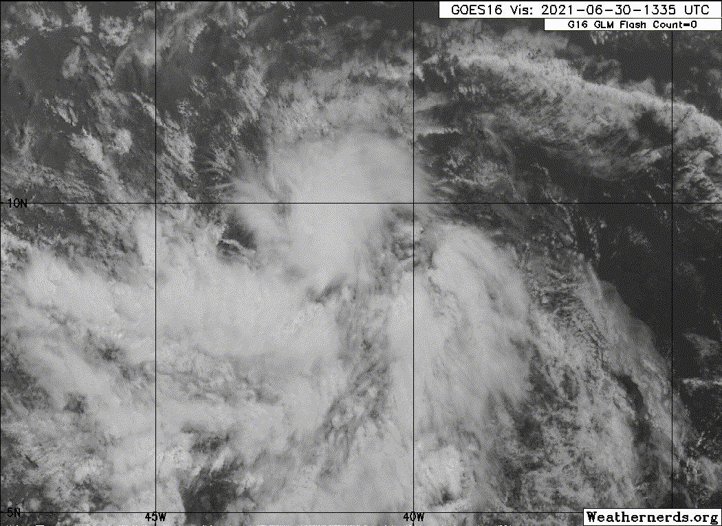
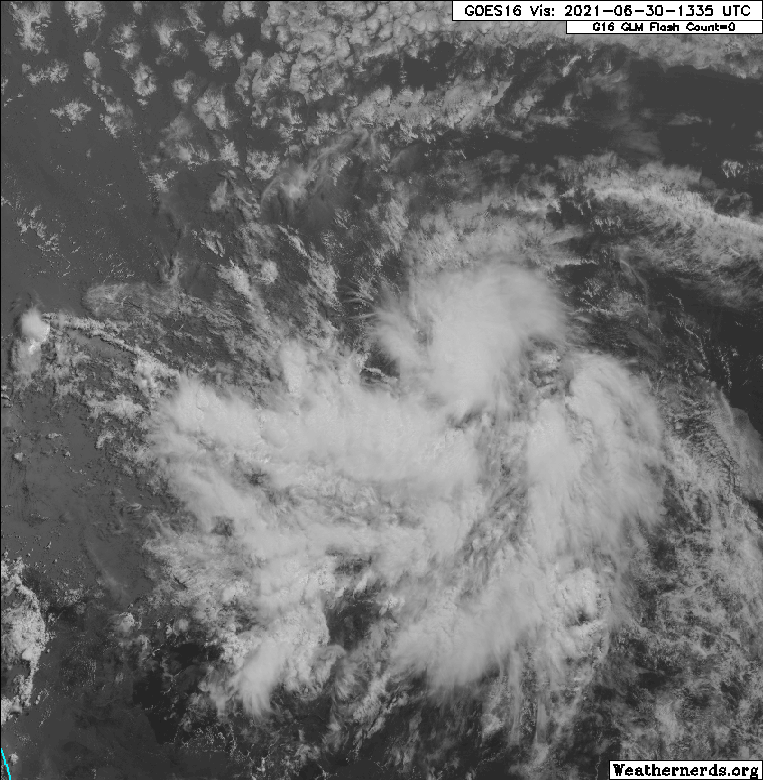
I am expecting advisories to be issued soon. Look at the spiral banding. VERY impressive for late june.
8 likes
-
TallyTracker
- Category 2

- Posts: 787
- Joined: Thu Oct 11, 2018 2:46 pm
Re: ATL: INVEST 97L - Discussion
I’d be quite comfortable initiating advisories on this system now. Predicting intensity? Now that is something I’d have trouble doing.
0 likes
Fran '96, Georges '98, Gordon '00, Gabrielle '01, Charley '04, Frances '04, Jeanne '04, Barry '07, Fay '08, Debby '12, Matthew '16, Emily '17, Irma '17, Michael ‘18, Elsa ‘21, Fred ‘21, Mindy ‘21, Nicole ‘22, Idalia ‘23, Debby ‘24, Helene ‘24
-
Aric Dunn
- Category 5
- Posts: 21238
- Age: 43
- Joined: Sun Sep 19, 2004 9:58 pm
- Location: Ready for the Chase.
- Contact:
Re: ATL: INVEST 97L - Discussion
Fully expect the 2pm TWO to be 90/90 and saying advisories later today or tonight.
9 likes
Note: If I make a post that is brief. Please refer back to previous posts for the analysis or reasoning. I do not re-write/qoute what my initial post said each time.
If there is nothing before... then just ask
Space & Atmospheric Physicist, Embry-Riddle Aeronautical University,
I believe the sky is falling...
If there is nothing before... then just ask
Space & Atmospheric Physicist, Embry-Riddle Aeronautical University,
I believe the sky is falling...
-
Sciencerocks
- Category 5
- Posts: 10181
- Age: 40
- Joined: Thu Jul 06, 2017 1:51 am
Re: ATL: INVEST 97L - Discussion
Within my opinion this is a depression. I'd be shocked if the nhc doesn't start advisories at 5pm est.
1 likes
-
Iceresistance

- Category 5
- Posts: 9579
- Age: 22
- Joined: Sat Oct 10, 2020 9:45 am
- Location: Tecumseh, OK/Norman, OK
Re: ATL: INVEST 97L - Discussion
SFLcane wrote:I am expecting advisories to be issued soon. Look at the spiral banding. VERY impressive for late june.
https://i.postimg.cc/J4BFfdWS/gfs.gif
What does this trend for later on this season? Any Analog years for a potential tropical storm in the MDR in June/Early July?
0 likes
Bill 2015 & Beta 2020
Winter 2020-2021
All observations are in Tecumseh, OK unless otherwise noted.
Winter posts are focused mainly for Oklahoma & Texas.
Take any of my forecasts with a grain of salt, refer to the NWS, SPC, and NHC for official information
Never say Never with weather! Because ANYTHING is possible!
Winter 2020-2021
All observations are in Tecumseh, OK unless otherwise noted.
Winter posts are focused mainly for Oklahoma & Texas.
Take any of my forecasts with a grain of salt, refer to the NWS, SPC, and NHC for official information
Never say Never with weather! Because ANYTHING is possible!
-
AlphaToOmega
- Category 5
- Posts: 1448
- Joined: Sat Jun 26, 2021 10:51 am
- Location: Somewhere in Massachusetts
Re: ATL: INVEST 97L - Discussion
Iceresistance wrote:SFLcane wrote:I am expecting advisories to be issued soon. Look at the spiral banding. VERY impressive for late june.
https://i.postimg.cc/J4BFfdWS/gfs.gif
What does this trend for later on this season? Any Analog years for a potential tropical storm in the MDR in June/Early July?
In this regard, probably 1933 or 2017
0 likes

Re: ATL: INVEST 97L - Discussion
Iceresistance wrote:SFLcane wrote:I am expecting advisories to be issued soon. Look at the spiral banding. VERY impressive for late june.
https://i.postimg.cc/J4BFfdWS/gfs.gif
What does this trend for later on this season? Any Analog years for a potential tropical storm in the MDR in June/Early July?
Dennis in 2005 comes to mind as well as the Trinitad hurricane in 1933. Also perhaps Bertha in 1996.
0 likes

Re: ATL: INVEST 97L - Discussion
Weather Dude wrote:All I'm saying is that I better not see even a single Frozen meme for this storm

Only thing I got on Elsa

1 likes
-
InfernoFlameCat
- Category 5
- Posts: 2127
- Age: 22
- Joined: Mon Dec 14, 2020 10:52 am
- Location: Buford, GA
Re: ATL: INVEST 97L - Discussion
Iceresistance wrote:SFLcane wrote:I am expecting advisories to be issued soon. Look at the spiral banding. VERY impressive for late june.
https://i.postimg.cc/J4BFfdWS/gfs.gif
What does this trend for later on this season? Any Analog years for a potential tropical storm in the MDR in June/Early July?
2005
0 likes
I am by no means a professional. DO NOT look at my forecasts for official information or make decisions based on what I post.
Goal: to become a registered expert over tropical and subtropical cyclones.
Goal: to become a registered expert over tropical and subtropical cyclones.
-
cycloneye
- Admin
- Posts: 149276
- Age: 69
- Joined: Thu Oct 10, 2002 10:54 am
- Location: San Juan, Puerto Rico
Re: ATL: INVEST 97L - Discussion
Showers and thunderstorms associated with a broad low pressure area
and tropical wave located about 1300 miles east-southeast of the
Windward Islands have become better organized since yesterday.
However, recent satellite wind data indicates that the disturbance
does not have a well-defined circulation. Environmental conditions
appear generally favorable for continued development, and a tropical
depression or storm is likely to form during the next day or two
while the system moves west-northwestward at 20 to 25 mph.
Interests in the Lesser Antilles should closely monitor the progress
of this system, as advisories on a potential tropical cyclone,
accompanied by tropical storm watches for portions of this area, are
likely to be issued later today.
* Formation chance through 48 hours...high...70 percent.
* Formation chance through 5 days...high...90 percent.
4 likes
Visit the Caribbean-Central America Weather Thread where you can find at first post web cams,radars
and observations from Caribbean basin members Click Here
and observations from Caribbean basin members Click Here
Who is online
Users browsing this forum: No registered users and 52 guests