ATL: CLAUDETTE - Remnants - Discussion
Moderator: S2k Moderators
-
ElectricStorm

- Category 5

- Posts: 5147
- Age: 25
- Joined: Tue Aug 13, 2019 11:23 pm
- Location: Norman, OK
Re: ATL: Potential Tropical Cyclone Three - Discussion
Not anything impressive with this one but you can't really expect much more than this for June. It'll be a close call on whether it can become a TD/TS before landfall but I think it will get there.
0 likes
B.S Meteorology, University of Oklahoma '25
Please refer to the NHC, NWS, or SPC for official information.
Please refer to the NHC, NWS, or SPC for official information.
-
cycloneye

- Admin

- Posts: 149514
- Age: 69
- Joined: Thu Oct 10, 2002 10:54 am
- Location: San Juan, Puerto Rico
Re: ATL: Potential Tropical Cyclone Three - Discussion
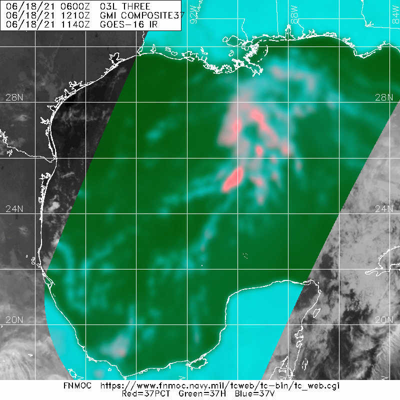
AL, 03, 2021061812, , BEST, 0, 259N, 915W, 30, 1007, LO
0 likes
Visit the Caribbean-Central America Weather Thread where you can find at first post web cams,radars
and observations from Caribbean basin members Click Here
and observations from Caribbean basin members Click Here
-
wxman57

- Moderator-Pro Met

- Posts: 23175
- Age: 68
- Joined: Sat Jun 21, 2003 8:06 pm
- Location: Houston, TX (southwest)
Re: ATL: Potential Tropical Cyclone Three - Discussion
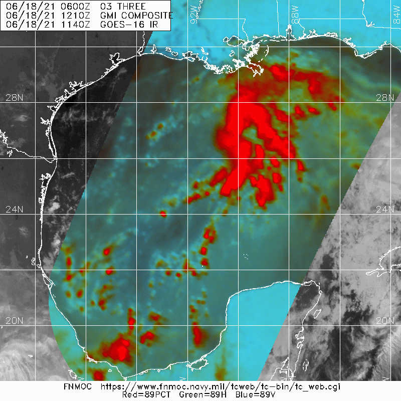
Nothing from recon since 30 min ago. May be a broad, weak swirl west of the convection near 26.5N / 91.6W. I think the plane could find some 35 kt winds in those squalls, but such winds are not circulating around any center.
1 likes
-
Stormcenter
- S2K Supporter

- Posts: 6689
- Joined: Wed Sep 03, 2003 11:27 am
- Location: Houston, TX
Re: ATL: Potential Tropical Cyclone Three - Discussion
IMO getting much better organized with every passing hour.
0 likes

Re: ATL: Potential Tropical Cyclone Three - Discussion
wxman57 wrote:Nothing from recon since 30 min ago. May be a broad, weak swirl west of the convection near 26.5N / 91.6W. I think the plane could find some 35 kt winds in those squalls, but such winds are not circulating around any center.
Air Force recon transmission issues have returned to be a pain once again. I really hope we don’t see a repeat of Eta’s situation sometime this season.
0 likes
Irene '11 Sandy '12 Hermine '16 5/15/2018 Derecho Fay '20 Isaias '20 Elsa '21 Henri '21 Ida '21
I am only a meteorology enthusiast who knows a decent amount about tropical cyclones. Look to the professional mets, the NHC, or your local weather office for the best information.
I am only a meteorology enthusiast who knows a decent amount about tropical cyclones. Look to the professional mets, the NHC, or your local weather office for the best information.
-
Yellow Evan

- Professional-Met

- Posts: 16241
- Age: 27
- Joined: Fri Jul 15, 2011 12:48 pm
- Location: Henderson, Nevada/Honolulu, HI
- Contact:
Re: ATL: Potential Tropical Cyclone Three - Discussion
Closed circulation is probably present, and deep convection coverage has increased since yesterday. This might be classifiable now.
0 likes
-
wxman57
- Moderator-Pro Met
- Posts: 23175
- Age: 68
- Joined: Sat Jun 21, 2003 8:06 pm
- Location: Houston, TX (southwest)
Re: ATL: Potential Tropical Cyclone Three - Discussion
Yellow Evan wrote:Closed circulation is probably present, and deep convection coverage has increased since yesterday. This might be classifiable now.
I'm trying to find an LLC on the high-res mesoscale loop at College of DuPage. I can see a trof axis, but no circulation. Would help if recon would report.
0 likes
-
wxman57
- Moderator-Pro Met
- Posts: 23175
- Age: 68
- Joined: Sat Jun 21, 2003 8:06 pm
- Location: Houston, TX (southwest)
Re: ATL: Potential Tropical Cyclone Three - Discussion
Finally, a recon report. A broad, weak swirl around 26N/91.2W. 0-5 kts over a large area. No difference from yesterday afternoon.
0 likes
-
JW-_-
Re: ATL: Potential Tropical Cyclone Three - Discussion
Pretty much be gales anywhere there's convection in the gom. Needs this within radar range to sort out.
0 likes
-
wxman57
- Moderator-Pro Met
- Posts: 23175
- Age: 68
- Joined: Sat Jun 21, 2003 8:06 pm
- Location: Houston, TX (southwest)
Re: ATL: Potential Tropical Cyclone Three - Discussion
Less than 10kt winds from 27.4N to 25.4N. Nothing outside of that convection, as far as wind.
0 likes

Re: ATL: Potential Tropical Cyclone Three - Discussion
Stormcenter wrote:IMO getting much better organized with every passing hour.
It sort of does. Storms are firing east and northeast of the general center. We have about 12-16 hours left until the center reaches the coast. It could make a run for TS (40 or so) as the 7:00am advisory notes sustained to 35 which is pretty much depression-level. I'd say it's 60/40 that it gets classified to TS at some point this afternoon. 06z mesoscale models like a last run at tightening right at landfall, so I'm going with them.
0 likes
-
MississippiWx

- S2K Supporter
- Posts: 1720
- Joined: Sat Aug 14, 2010 1:44 pm
- Location: Hattiesburg, Mississippi
Re: ATL: Potential Tropical Cyclone Three - Discussion
wxman57 wrote:Finally, a recon report. A broad, weak swirl around 26N/91.2W. 0-5 kts over a large area. No difference from yesterday afternoon.
I’d argue it’s much less broad than yesterday which isn’t saying much. Seems to be improving by each frame. Convective organization is much more concentrated which helps as well in tightening the circulation. Minimal tropical storm still looks reasonable, but doesn’t matter other than adding a number to the list.
0 likes
This post is not an official forecast and should not be used as such. It is just the opinion of MississippiWx and may or may not be backed by sound meteorological data. It is not endorsed by any professional institution including storm2k.org. For Official Information please refer to the NHC and NWS products.
-
wxman57
- Moderator-Pro Met
- Posts: 23175
- Age: 68
- Joined: Sat Jun 21, 2003 8:06 pm
- Location: Houston, TX (southwest)
Re: ATL: Potential Tropical Cyclone Three - Discussion
MississippiWx wrote:wxman57 wrote:Finally, a recon report. A broad, weak swirl around 26N/91.2W. 0-5 kts over a large area. No difference from yesterday afternoon.
I’d argue it’s much less broad than yesterday which isn’t saying much. Seems to be improving by each frame. Convective organization is much more concentrated which helps as well in tightening the circulation. Minimal tropical storm still looks reasonable, but doesn’t matter other than adding a number to the list.
My forecast has it a TS this evening, but mostly due to straight-line winds in squalls well east of the center. Nothing circulating around the center.
2 likes
-
JW-_-
Re: ATL: Potential Tropical Cyclone Three - Discussion
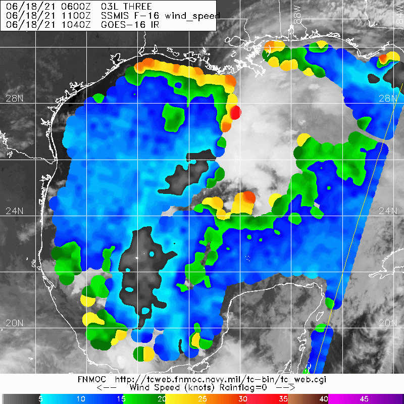
Those 30kts on the image just above. the 24N line is where i thought the SW side of the vort was @ the time of the pass.
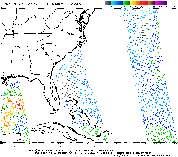
the earlier pass had 30kt gales to SW of the mess.
Last edited by JW-_- on Fri Jun 18, 2021 8:39 am, edited 1 time in total.
0 likes
-
cycloneye
- Admin
- Posts: 149514
- Age: 69
- Joined: Thu Oct 10, 2002 10:54 am
- Location: San Juan, Puerto Rico
Re: ATL: Potential Tropical Cyclone Three - Discussion
2 likes
Visit the Caribbean-Central America Weather Thread where you can find at first post web cams,radars
and observations from Caribbean basin members Click Here
and observations from Caribbean basin members Click Here

Re: ATL: Potential Tropical Cyclone Three - Discussion
wxman57 wrote:Less than 10kt winds from 27.4N to 25.4N. Nothing outside of that convection, as far as wind.
Maybe something north of where they are looking now 27.5N 91W or maybe it never closes off.
Last edited by tailgater on Fri Jun 18, 2021 9:50 am, edited 2 times in total.
1 likes
The following post is NOT an official forecast and should not be used as such. It is just the opinion of the poster and may or may not be backed by sound meteorological data. It is NOT endorsed by any professional institution including storm2k.org For Official Information please refer to the NHC and NWS products.
-
Yellow Evan
- Professional-Met
- Posts: 16241
- Age: 27
- Joined: Fri Jul 15, 2011 12:48 pm
- Location: Henderson, Nevada/Honolulu, HI
- Contact:
Re: ATL: Potential Tropical Cyclone Three - Discussion
Per recon this is technically closed, so with that and the slow improvement in organization, I think this barely qualifies as a tropical cyclone.
0 likes
-
wxman57
- Moderator-Pro Met
- Posts: 23175
- Age: 68
- Joined: Sat Jun 21, 2003 8:06 pm
- Location: Houston, TX (southwest)
Re: ATL: Potential Tropical Cyclone Three - Discussion
Yellow Evan wrote:Per recon this is technically closed, so with that and the slow improvement in organization, I think this barely qualifies as a tropical cyclone.
I don't think that a west wind of a few mph within a broad area of light winds over 100 miles across really qualifies as a "well-defined" low-level center. I would call it a disturbance until it has a tight center. Doesn't matter as far as impacts. The squalls could produce some straight-line winds to 40 mph, and they'll produce 6-8 inches of rain regardless of how this system is classified. We'll know in a few minutes if the NHC has seen enough to call it a depression. Certainly, no evidence of TS winds from recon. I'm seeing a couple 25-30 kt winds in the squalls well NE of the weak swirls.
0 likes
Re: ATL: Potential Tropical Cyclone Three - Discussion
Some dark grey clouds to the south here in Pensacola. Looks like the first little bit is coming up and through, then we'll have a break. It's the eastern edge of the band that went through New Orleans an hour or so ago. SELA and southern MS look to have the rainfall bullseyes on them based on current rotation.
https://radar.weather.gov/?settings=v1_ ... J1ZX0%3D#/
There's some rain. Also, look at the true color zoom-out from TT. Convection is blowing up in a banding style just east of 90W.
https://www.tropicaltidbits.com/sat/sat ... =truecolor
https://radar.weather.gov/?settings=v1_ ... J1ZX0%3D#/
There's some rain. Also, look at the true color zoom-out from TT. Convection is blowing up in a banding style just east of 90W.
https://www.tropicaltidbits.com/sat/sat ... =truecolor
Last edited by Steve on Fri Jun 18, 2021 9:44 am, edited 1 time in total.
2 likes
Who is online
Users browsing this forum: No registered users and 18 guests