ATL: FRED - Models

Moderator: S2k Moderators

Message
Author
User avatar
Blown Away
S2K Supporter
S2K Supporter
Posts: 10140
Joined: Wed May 26, 2004 6:17 am

Re: ATL: SIX - Models

#261 Postby Blown Away » Tue Aug 10, 2021 7:27 am

NDG wrote:One of the main reasons why the 06z HWRF is so strong is because it shows 06L making landfall in the far eastern tip of Hispaniola and quickly move back offshre, thus it strengthens faster.


It's that simple, so any N adjustments over next 36 hours may play big down the road.
5 likes   
Hurricane Eye Experience: David 79, Irene 99, Frances 04, Jeanne 04, Wilma 05... EYE COMING MY WAY IN 2024…
Hurricane Brush Experience: Andrew 92, Erin 95, Floyd 99, Matthew 16, Irma 17, Ian 22, Nicole 22…

User avatar
Blown Away
S2K Supporter
S2K Supporter
Posts: 10140
Joined: Wed May 26, 2004 6:17 am

Re: ATL: SIX - Models

#262 Postby Blown Away » Tue Aug 10, 2021 7:29 am

Image
06z HWRF...
1 likes   
Hurricane Eye Experience: David 79, Irene 99, Frances 04, Jeanne 04, Wilma 05... EYE COMING MY WAY IN 2024…
Hurricane Brush Experience: Andrew 92, Erin 95, Floyd 99, Matthew 16, Irma 17, Ian 22, Nicole 22…

Shell Mound
Category 5
Category 5
Posts: 2434
Age: 32
Joined: Thu Sep 07, 2017 3:39 pm
Location: St. Petersburg, FL → Scandinavia

Re: ATL: SIX - Models

#263 Postby Shell Mound » Tue Aug 10, 2021 7:30 am

NDG wrote:One of the main reasons why the 06z HWRF is so strong is because it shows 06L making landfall in the far eastern tip of Hispaniola and quickly move back offshre, thus it strengthens faster.

I still think its intensity over the Bahamas is far too high, given the UL wind fields on the ECMWF at that time. If the ULL were positioned southwest rather than northwest of PTC Six at that time, it would certainly support intensification similar to that which the HWRF indicates, but instead PTC Six is going to be sited in a col between an UL anticyclone to its east and the ULL over Florida. This would impart net southerly and westerly shear over the system. Even if VWS remains rather low over the centre, the orientation of the wind vectors with height would not allow PTC Six to establish outflow channels prior to reaching the eastern GoM. So at most I would expect a low-end TS by the time it makes its closest approach to the Miami metropolitan area and the Keys.
0 likes   
CVW / MiamiensisWx / Shell Mound
The posts in this forum are NOT official forecasts and should not be used as such. They are just the opinion of the poster and may or may not be backed by sound meteorological data. They are NOT endorsed by any professional institution or STORM2K. For official information, please refer to products from the NHC and NWS.

jlauderdal
S2K Supporter
S2K Supporter
Posts: 7177
Joined: Wed May 19, 2004 5:46 am
Location: NE Fort Lauderdale
Contact:

Re: ATL: SIX - Models

#264 Postby jlauderdal » Tue Aug 10, 2021 7:55 am

BobHarlem wrote:Can't have a model thread without some prime HWRF example images featuring downtown Miami and Port Miami for the cruisers on a departure day.

https://i.imgur.com/VHdH6hi.png


My roof has been torn off at least 10 different times by the hwrf and gfs. Roof is still there, never had roof damage even in Wilma. One of these times but dont think its this one, enough ridging in place for gulf action.
2 likes   

jlauderdal
S2K Supporter
S2K Supporter
Posts: 7177
Joined: Wed May 19, 2004 5:46 am
Location: NE Fort Lauderdale
Contact:

Re: ATL: SIX - Models

#265 Postby jlauderdal » Tue Aug 10, 2021 7:56 am

NDG wrote:One of the main reasons why the 06z HWRF is so strong is because it shows 06L making landfall in the far eastern tip of Hispaniola and quickly move back offshre, thus it strengthens faster.

Aanother 10-20 mb reduction just because its the HWRF regardless of the track its taking.
1 likes   

SootyTern
S2K Supporter
S2K Supporter
Posts: 315
Age: 56
Joined: Sun Sep 05, 2004 5:09 pm
Location: NYC (formerly Homestead, FL)

Re: ATL: SIX - Models

#266 Postby SootyTern » Tue Aug 10, 2021 8:33 am

complex uncertain forecast+ skin in the game= very interesting week for tracking
3 likes   
Disclaimer:
The posts in this forum are NOT official forecasts and should not be used as such. For official information, please refer to the NHC and NWS products.

Gulf Coast: Opal '95 Georges '98 / So Fla: Katrina '05 Wilma '05 Irma '17

Hurricane Mike
Category 2
Category 2
Posts: 644
Joined: Tue Apr 10, 2018 7:44 am

Re: ATL: SIX - Models

#267 Postby Hurricane Mike » Tue Aug 10, 2021 8:33 am

That HWRF puts a 973 mb hurricane over Biscayne Bay.
0 likes   

BobHarlem
Category 5
Category 5
Posts: 2034
Joined: Thu Oct 20, 2005 6:11 pm

Re: ATL: SIX - Models

#268 Postby BobHarlem » Tue Aug 10, 2021 8:45 am

12z early models

Image
0 likes   

User avatar
robbielyn
Category 5
Category 5
Posts: 1298
Joined: Wed May 07, 2003 9:45 am
Location: brooksville, fl

Re: ATL: SIX - Models

#269 Postby robbielyn » Tue Aug 10, 2021 8:53 am

[Youtube][/Youtube]
toad strangler wrote:I'm proud of the HWRF for not going to 925 on a run like that :lol:

Either that or it's really going to be a weak system.
0 likes   
Robbielyn McCrary
I know just about enough to sound like I know what I'm talking about sometimes. But for your safety please follow the nhc for truly professional forecasting. :D

AlphaToOmega
Category 5
Category 5
Posts: 1448
Joined: Sat Jun 26, 2021 10:51 am
Location: Somewhere in Massachusetts

Re: ATL: SIX - Models

#270 Postby AlphaToOmega » Tue Aug 10, 2021 8:53 am

We often discuss how bullish the HWRF is, but there is no discussion of this :D
Image
Image
1 likes   

User avatar
Blown Away
S2K Supporter
S2K Supporter
Posts: 10140
Joined: Wed May 26, 2004 6:17 am

Re: ATL: SIX - Models

#271 Postby Blown Away » Tue Aug 10, 2021 9:33 am

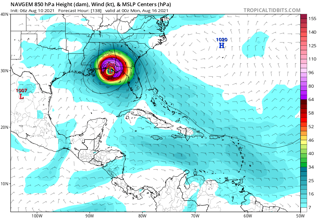
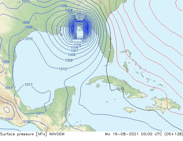
Image
06z NAVGEM...
0 likes   
Hurricane Eye Experience: David 79, Irene 99, Frances 04, Jeanne 04, Wilma 05... EYE COMING MY WAY IN 2024…
Hurricane Brush Experience: Andrew 92, Erin 95, Floyd 99, Matthew 16, Irma 17, Ian 22, Nicole 22…

tolakram
Admin
Admin
Posts: 19990
Age: 61
Joined: Sun Aug 27, 2006 8:23 pm
Location: Florence, KY (name is Mark)

Re: ATL: SIX - Models

#272 Postby tolakram » Tue Aug 10, 2021 9:40 am

NAVGEM has never been wrong .. wait, right.
5 likes   
M a r k
- - - - -
Join us in chat: Storm2K Chatroom Invite. Android and IOS apps also available.

The posts in this forum are NOT official forecasts and should not be used as such. Posts are NOT endorsed by any professional institution or STORM2K.org. For official information and forecasts, please refer to NHC and NWS products.

User avatar
NDG
S2K Supporter
S2K Supporter
Posts: 15446
Joined: Sun Jul 09, 2006 10:14 pm
Location: Orlando, FL

Re: ATL: SIX - Models

#273 Postby NDG » Tue Aug 10, 2021 9:41 am

Close look at 06z Euro Ensembles.

Image
0 likes   

tolakram
Admin
Admin
Posts: 19990
Age: 61
Joined: Sun Aug 27, 2006 8:23 pm
Location: Florence, KY (name is Mark)

Re: ATL: SIX - Models

#274 Postby tolakram » Tue Aug 10, 2021 9:56 am

6Z Euro
Image
0 likes   
M a r k
- - - - -
Join us in chat: Storm2K Chatroom Invite. Android and IOS apps also available.

The posts in this forum are NOT official forecasts and should not be used as such. Posts are NOT endorsed by any professional institution or STORM2K.org. For official information and forecasts, please refer to NHC and NWS products.

AlphaToOmega
Category 5
Category 5
Posts: 1448
Joined: Sat Jun 26, 2021 10:51 am
Location: Somewhere in Massachusetts

Re: ATL: SIX - Models

#275 Postby AlphaToOmega » Tue Aug 10, 2021 9:57 am

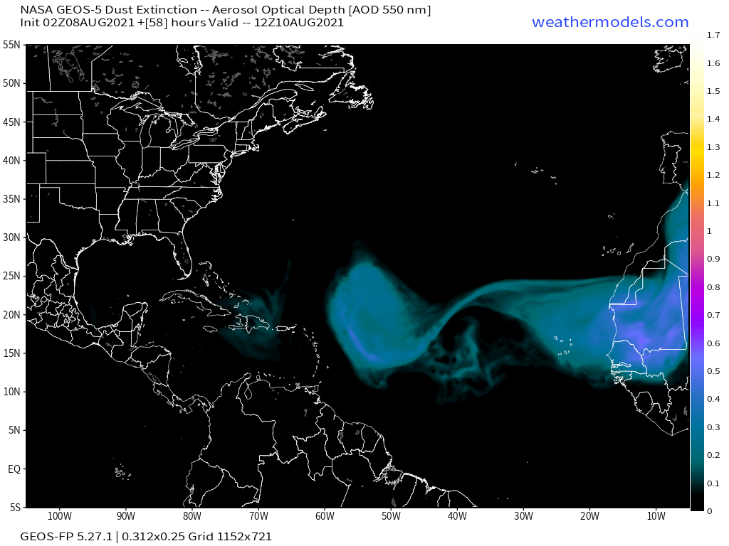
There is very little dry air in the Atlantic as of now. That is not going to be a factor in the development of PTC 06L.
Image
2 likes   

tolakram
Admin
Admin
Posts: 19990
Age: 61
Joined: Sun Aug 27, 2006 8:23 pm
Location: Florence, KY (name is Mark)

Re: ATL: SIX - Models

#276 Postby tolakram » Tue Aug 10, 2021 10:02 am

AlphaToOmega wrote:There is very little dry air in the Atlantic as of now. That is not going to be a factor in the development of PTC 06L.
https://i.postimg.cc/Znd6hJcR/image.png


No dust maybe, but plenty of dry air. Watch the low and mid level WV loops.

https://weather.cod.edu/satrad/?parms=meso-meso1-10-48-1-25-1&checked=map&colorbar=undefined
1 likes   
M a r k
- - - - -
Join us in chat: Storm2K Chatroom Invite. Android and IOS apps also available.

The posts in this forum are NOT official forecasts and should not be used as such. Posts are NOT endorsed by any professional institution or STORM2K.org. For official information and forecasts, please refer to NHC and NWS products.

User avatar
chaser1
S2K Supporter
S2K Supporter
Posts: 5407
Age: 64
Joined: Sat Oct 15, 2005 5:59 pm
Location: Longwood, Fl

Re: ATL: SIX - Models

#277 Postby chaser1 » Tue Aug 10, 2021 10:02 am

robbielyn wrote:[url][/url]
toad strangler wrote:I'm proud of the HWRF for not going to 925 on a run like that :lol:

Either that or it's really going to be a weak system.


That's too funny Toad :lol: Could more or less hover right around 999mb while tracking over the Keys, but then bomb out once pushing NW into the E. GOM?

Is it just me or does it seem that lately we're seeing more Tropical Cyclones playing the Mountainous region - Death March game, just to find a sweet spot to squeeze on by and re-intensify thereafter. Seems like back in the day, Hispaniola had largely acted like the Roach Motel. Hurricane's checked in, but seldom checked out LOL.
3 likes   
Andy D

(For official information, please refer to the NHC and NWS products.)

User avatar
SFLcane
S2K Supporter
S2K Supporter
Posts: 10162
Age: 47
Joined: Sat Jun 05, 2010 1:44 pm
Location: Lake Worth Florida

Re: ATL: SIX - Models

#278 Postby SFLcane » Tue Aug 10, 2021 10:30 am

Big shift north in 12z Icon
0 likes   

BobHarlem
Category 5
Category 5
Posts: 2034
Joined: Thu Oct 20, 2005 6:11 pm

Re: ATL: SIX - Models

#279 Postby BobHarlem » Tue Aug 10, 2021 10:39 am

Icon very large shift right (Prior run went through the Keys into the Gulf offshore the W Fl coast), also notable the wave entering from the east.
Image
0 likes   

tolakram
Admin
Admin
Posts: 19990
Age: 61
Joined: Sun Aug 27, 2006 8:23 pm
Location: Florence, KY (name is Mark)

Re: ATL: SIX - Models

#280 Postby tolakram » Tue Aug 10, 2021 10:42 am

12Z GFS init
Image
0 likes   
M a r k
- - - - -
Join us in chat: Storm2K Chatroom Invite. Android and IOS apps also available.

The posts in this forum are NOT official forecasts and should not be used as such. Posts are NOT endorsed by any professional institution or STORM2K.org. For official information and forecasts, please refer to NHC and NWS products.


Return to “2021”

Who is online

Users browsing this forum: No registered users and 25 guests