CPAC: LINDA - Post-Tropical

Moderator: S2k Moderators

Message
Author
User avatar
Yellow Evan
Professional-Met
Professional-Met
Posts: 16143
Age: 27
Joined: Fri Jul 15, 2011 12:48 pm
Location: Henderson, Nevada/Honolulu, HI
Contact:

Re: EPAC: LINDA - Hurricane

#261 Postby Yellow Evan » Sat Aug 14, 2021 7:23 pm

TXPZ23 KNES 142358
TCSENP

A. 12E (LINDA)

B. 14/2330Z

C. 19.2N

D. 117.6W

E. ONE/GOES-W

F. T5.5/6.0

G. IR/EIR/VIS

H. REMARKS...WMG EYE SURROUNDED BY LG AND EMBEDDED IN LG YIELDS A DT OF
5.5 AFTER AN EYE ADJ OF 0.5. MET AND PT AGREE AND ARE EQUAL TO 5.5 BASED
ON A DEVELOPING SLOWLY TREND IN THE LAST 24 HOURS. FT IS BASED ON DT.

I. ADDL POSITIONS

NIL


...TUGGLE
0 likes   

User avatar
Kingarabian
S2K Supporter
S2K Supporter
Posts: 15980
Joined: Sat Aug 08, 2009 3:06 am
Location: Honolulu, Hawaii

Re: EPAC: LINDA - Hurricane

#262 Postby Kingarabian » Sat Aug 14, 2021 7:42 pm

Just so photogenic:
Image
9 likes   
RIP Kobe Bryant

User avatar
Ubuntwo
Category 5
Category 5
Posts: 1406
Age: 31
Joined: Thu Oct 05, 2017 10:41 pm

Re: EPAC: LINDA - Hurricane

#263 Postby Ubuntwo » Sat Aug 14, 2021 7:46 pm

Kingarabian wrote:Just so photogenic:
https://i.imgur.com/JoV29Hr.gif

Gorgeous storm. Look at those eyewall mesovorts.
2 likes   
Kendall -> SLO -> PBC

Memorable Storms: Katrina (for its Florida landfall...) Wilma Matthew Irma

User avatar
Kingarabian
S2K Supporter
S2K Supporter
Posts: 15980
Joined: Sat Aug 08, 2009 3:06 am
Location: Honolulu, Hawaii

Re: EPAC: LINDA - Hurricane

#264 Postby Kingarabian » Sat Aug 14, 2021 7:49 pm

Ubuntwo wrote:
Kingarabian wrote:Just so photogenic:
https://i.imgur.com/JoV29Hr.gif

Gorgeous storm. Look at those eyewall mesovorts.


For sure. I'll also backtrack and say this is not annular yet because the limited banding is persisting. Will be interesting to see how it transitions in the next 48-72 hours when it encounters some drier air but keeps the low shear.
1 likes   
RIP Kobe Bryant

Sciencerocks
Category 5
Category 5
Posts: 9155
Age: 39
Joined: Thu Jul 06, 2017 1:51 am

Re: EPAC: LINDA - Hurricane

#265 Postby Sciencerocks » Sat Aug 14, 2021 9:30 pm

Image
0 likes   

Astromanía
Category 2
Category 2
Posts: 779
Age: 26
Joined: Sat Aug 25, 2018 10:34 pm
Location: Monterrey, N.L, México

Re: EPAC: LINDA - Hurricane

#266 Postby Astromanía » Sat Aug 14, 2021 9:41 pm

So, how much ACE do you guys think Linda can produce
0 likes   

User avatar
cycloneye
Admin
Admin
Posts: 145299
Age: 68
Joined: Thu Oct 10, 2002 10:54 am
Location: San Juan, Puerto Rico

Re: EPAC: LINDA - Hurricane

#267 Postby cycloneye » Sat Aug 14, 2021 9:43 pm

Hurricane Linda Discussion Number 20
NWS National Hurricane Center Miami FL EP122021
800 PM PDT Sat Aug 14 2021

Although Linda is still quite an impressive and powerful hurricane,
inner-core cloud tops have been warming during the past several
hours. Furthermore, the eye has become more obscured during the
past few hours, with convoluted cloud elements and a few
mesovortices identifiable in High resolution visible imagery. A
series of microwave images from earlier today, suggest a concentric,
outer convective ring may be forming, usually indicative of an
eyewall replacement cycle. The latest subjective and objective
satellite intensity estimates indicate that Linda has weakened to
110 kt, and the initial intensity is lowered to this value for this
advisory.

With the possibility that Linda maybe undergoing an eyewall
replacement cycle, fluctuations in strength are possible during the
next few hours. Regardless of any inner-core structural changes,
Linda will be moving over gradually decreasing oceanic temperatures
and into a more statically stable and drier surrounding environment
during the next several days. Based on the statistical GFS and
ECMWF SHIPS intensity guidance and the large-scale and regional
models, Linda should begin a weakening trend soon, if it hasn't
started already. The NHC intensity forecast resembles the previous
advisory, and is in best agreement with the HCCA and IVCN intensity
consensus aids.

Linda is embedded within the mid-tropospheric south peripheral flow
of a strengthening ridge to the north, and the initial motion is
estimated to be west-northwestward, or 285/12 kt. This subtropical
ridge is forecast to build back westward to the northwest of Linda
during the next 24-36 h, inducing a turn toward the west-southwest.
Around early Tuesday, the hurricane is expected to turn back toward
the west and west-northwest in response to a mid-level cut-off low
forming west of the Baja California peninsula. The official track
forecast is based primarily on the TVCN consensus model and is quite
similar to the previous NHC forecast.


FORECAST POSITIONS AND MAX WINDS

INIT 15/0300Z 19.3N 118.2W 110 KT 125 MPH
12H 15/1200Z 19.4N 119.9W 110 KT 125 MPH
24H 16/0000Z 19.1N 121.9W 90 KT 105 MPH
36H 16/1200Z 18.6N 123.7W 80 KT 90 MPH
48H 17/0000Z 18.1N 125.4W 75 KT 85 MPH
60H 17/1200Z 18.0N 127.1W 65 KT 75 MPH
72H 18/0000Z 18.2N 128.9W 60 KT 70 MPH
96H 19/0000Z 19.6N 133.2W 50 KT 60 MPH
120H 20/0000Z 21.6N 137.9W 40 KT 45 MPH

$$
Forecaster Roberts
0 likes   
Visit the Caribbean-Central America Weather Thread where you can find at first post web cams,radars
and observations from Caribbean basin members Click Here

User avatar
Yellow Evan
Professional-Met
Professional-Met
Posts: 16143
Age: 27
Joined: Fri Jul 15, 2011 12:48 pm
Location: Henderson, Nevada/Honolulu, HI
Contact:

Re: EPAC: LINDA - Hurricane

#268 Postby Yellow Evan » Sat Aug 14, 2021 9:54 pm

This has kept its banding so non-annular for now but can’t find any microwaves that have an ERC.
1 likes   

User avatar
Yellow Evan
Professional-Met
Professional-Met
Posts: 16143
Age: 27
Joined: Fri Jul 15, 2011 12:48 pm
Location: Henderson, Nevada/Honolulu, HI
Contact:

Re: EPAC: LINDA - Hurricane

#269 Postby Yellow Evan » Sun Aug 15, 2021 1:08 am

If this does ERC and lets in dry air which given how convective shallow it is, going to be tough for Linda to recover though lack of shear will probably help. I’m inclined to think we’ll see one of those annular Category 1’s down the line.
0 likes   

User avatar
Kingarabian
S2K Supporter
S2K Supporter
Posts: 15980
Joined: Sat Aug 08, 2009 3:06 am
Location: Honolulu, Hawaii

Re: EPAC: LINDA - Hurricane

#270 Postby Kingarabian » Sun Aug 15, 2021 1:11 am

Gradually losing latitude will eventually bring it back over marginally warm waters.
Image
Last edited by Kingarabian on Sun Aug 15, 2021 5:26 am, edited 2 times in total.
0 likes   
RIP Kobe Bryant

Sciencerocks
Category 5
Category 5
Posts: 9155
Age: 39
Joined: Thu Jul 06, 2017 1:51 am

Re: EPAC: LINDA - Hurricane

#271 Postby Sciencerocks » Sun Aug 15, 2021 2:56 am

Image
0 likes   

User avatar
cycloneye
Admin
Admin
Posts: 145299
Age: 68
Joined: Thu Oct 10, 2002 10:54 am
Location: San Juan, Puerto Rico

Re: EPAC: LINDA - Hurricane

#272 Postby cycloneye » Sun Aug 15, 2021 3:49 am

Hurricane Linda Discussion Number 21
NWS National Hurricane Center Miami FL EP122021
200 AM PDT Sun Aug 15 2021

Some obvious changes have been noted with Linda during the past few
hours. Inner-core cloud top temperatures have continued to warm,
particularly in the western semicircle, and banding features have
appeared in the eastern part of the cyclone. Overall, the cloud
pattern has quickly become asymmetric and the eyewall could be open
in the western quadrant. It's been several hours since we've had a
quality microwave overpass, so it's unclear whether or not Linda's
undergoing an eyewall replacement cycle. Using a consensus of the
Final T- and CI-numbers from TAFB and SAB, the initial intensity is
lowered to 100 kt for this advisory.

It appears that Linda is finally beginning a slow weakening trend.
The hurricane will soon be moving over gradually decreasing sea
surface temperatures and into more dry, stable marine layer air mass
later tonight. It may already be ingesting some dry air from the
west as a dry slot has become evident in the southern semicircle.
These impeding environmental contributions are expected to further
weaken the hurricane during the next several days. No significant
changes to the previous intensity forecast were made, and the latest
advisory continues to follow the HCCA and IVCN intensity consensus
models.

The initial motion is estimated to be due west, or 270/10 kt. The
track prediction philosophy remains unchanged as in the previous
advisory. A mid-tropospheric ridge situated north of the hurricane
is still forecast to build back westward to the northwest of Linda
during the next 24 h, instigating a turn toward the west-southwest.
By the 48-h period, Linda should to turn back toward the west and
west-northwest in response to a mid-level cut-off low or trough
developing west of the Baja California peninsula. The official track
forecast is nudged closer to the TVCN consensus model and is
basically an update of the previous NHC forecast.

A 0359 UTC METOP-A scatterometer pass indicated that Linda's wind
radii had contracted some, and adjustments were made, accordingly.


FORECAST POSITIONS AND MAX WINDS

INIT 15/0900Z 19.3N 119.2W 100 KT 115 MPH
12H 15/1800Z 19.1N 120.7W 90 KT 105 MPH
24H 16/0600Z 18.6N 122.6W 85 KT 100 MPH
36H 16/1800Z 18.0N 124.3W 80 KT 90 MPH
48H 17/0600Z 17.7N 125.9W 70 KT 80 MPH
60H 17/1800Z 17.9N 127.6W 65 KT 75 MPH
72H 18/0600Z 18.4N 129.6W 60 KT 70 MPH
96H 19/0600Z 20.2N 134.4W 50 KT 60 MPH
120H 20/0600Z 22.1N 139.5W 40 KT 45 MPH

$$
Forecaster Roberts
0 likes   
Visit the Caribbean-Central America Weather Thread where you can find at first post web cams,radars
and observations from Caribbean basin members Click Here

User avatar
Kingarabian
S2K Supporter
S2K Supporter
Posts: 15980
Joined: Sat Aug 08, 2009 3:06 am
Location: Honolulu, Hawaii

Re: EPAC: LINDA - Hurricane

#273 Postby Kingarabian » Sun Aug 15, 2021 5:21 am

Some kind of ERC dry air intrusion combo going on:
Image
0 likes   
RIP Kobe Bryant

User avatar
cheezyWXguy
Category 5
Category 5
Posts: 6108
Joined: Mon Feb 13, 2006 12:29 am
Location: Dallas, TX

Re: EPAC: LINDA - Hurricane

#274 Postby cheezyWXguy » Sun Aug 15, 2021 10:27 am

Surprised Linda isn’t getting more attention, hurricane structures don’t get a whole lot more annular than Linda is right now
0 likes   

User avatar
Teban54
Category 5
Category 5
Posts: 3204
Joined: Sat May 19, 2018 1:19 pm

Re: EPAC: LINDA - Hurricane

#275 Postby Teban54 » Sun Aug 15, 2021 10:45 am

cheezyWXguy wrote:Surprised Linda isn’t getting more attention, hurricane structures don’t get a whole lot more annular than Linda is right now


Probably because people have already been spoiled by Felicia. Plus, most Atlantic folks are likely watching Fred, Grace and 96L.

Edit: I would say it's absolutely astonishing that after years of people yelling at those who throw the 'A' word, we now have two actual annular hurricanes in the same season, in a basin that's supposed to be hostile for development.
Last edited by Teban54 on Sun Aug 15, 2021 10:57 am, edited 1 time in total.
0 likes   

User avatar
ScottNAtlanta
Category 5
Category 5
Posts: 2367
Joined: Sat May 25, 2013 3:11 pm
Location: Atlanta, GA

Re: EPAC: LINDA - Hurricane

#276 Postby ScottNAtlanta » Sun Aug 15, 2021 10:52 am

One key with Annular Hurricanes is that they dont weaken very quickly, even when conditions become less than ideal. It will be interesting as to how long Linda holds this structure. It looked annular to me last night. You dont see many like that.
0 likes   
The posts in this forum are NOT official forecast and should not be used as such. They are just the opinion of the poster and may or may not be backed by sound meteorological data. They are NOT endorsed by any professional institution or storm2k.org. For official information, please refer to the NHC and NWS products.

User avatar
ScottNAtlanta
Category 5
Category 5
Posts: 2367
Joined: Sat May 25, 2013 3:11 pm
Location: Atlanta, GA

Re: EPAC: LINDA - Hurricane

#277 Postby ScottNAtlanta » Sun Aug 15, 2021 11:00 am

Kingarabian wrote:Some kind of ERC dry air intrusion combo going on:
https://i.postimg.cc/K8WKnfzj/goes17-ir-12-E-202108150636.gif


Usually dry air intrusion would have to work its way in from the outside. It wouldn't just appear in the eye.
1 likes   
The posts in this forum are NOT official forecast and should not be used as such. They are just the opinion of the poster and may or may not be backed by sound meteorological data. They are NOT endorsed by any professional institution or storm2k.org. For official information, please refer to the NHC and NWS products.

User avatar
Yellow Evan
Professional-Met
Professional-Met
Posts: 16143
Age: 27
Joined: Fri Jul 15, 2011 12:48 pm
Location: Henderson, Nevada/Honolulu, HI
Contact:

Re: EPAC: LINDA - Hurricane

#278 Postby Yellow Evan » Sun Aug 15, 2021 11:03 am

TXPZ23 KNES 151206
TCSENP

A. 12E (LINDA)

B. 15/1130Z

C. 19.3N

D. 119.7W

E. ONE/GOES-W

F. T4.5/5.5

G. IR/EIR/SWIR

H. REMARKS...WMG EYE SURROUNDED BY MG AND EMBEDDED IN MG RESULTS IN AN E#
OF 4.5 WITH NO EADJ FOR A DT OF 4.5. MET AND PT=5.0. FT IS BASED ON DT.

I. ADDL POSITIONS

NIL


...KONON
0 likes   

User avatar
Yellow Evan
Professional-Met
Professional-Met
Posts: 16143
Age: 27
Joined: Fri Jul 15, 2011 12:48 pm
Location: Henderson, Nevada/Honolulu, HI
Contact:

Re: EPAC: LINDA - Hurricane

#279 Postby Yellow Evan » Sun Aug 15, 2021 11:16 am

0 likes   

User avatar
Yellow Evan
Professional-Met
Professional-Met
Posts: 16143
Age: 27
Joined: Fri Jul 15, 2011 12:48 pm
Location: Henderson, Nevada/Honolulu, HI
Contact:

Re: EPAC: LINDA - Hurricane

#280 Postby Yellow Evan » Sun Aug 15, 2021 11:17 am

000
WTPZ42 KNHC 151432
TCDEP2

Hurricane Linda Discussion Number 22
NWS National Hurricane Center Miami FL EP122021
500 AM HST Sun Aug 15 2021

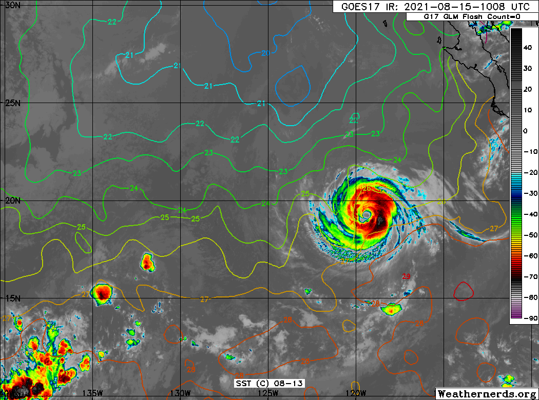
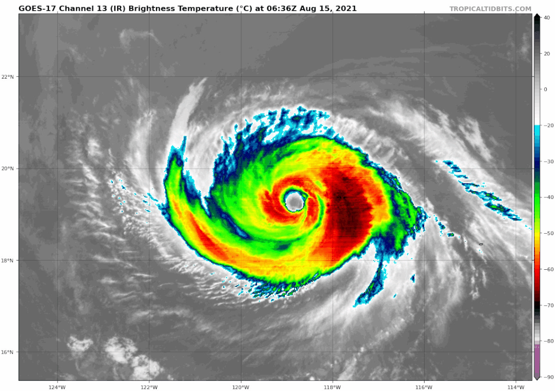
As was hypothesized in the previous advisory, it appears that Linda
is completing an eyewall replacement. An 0918 UTC GCOM AMSR2 pass
revealed the last-remaining vestiges of an inner eyewall decaying
within a newer, larger eye, which is estimated to be 35 n mi in
diameter based on the 89-GHz channel imagery. While the microwave
data still showed a few banding features on the western side of the
circulation, the hurricane has taken on annular characteristics,
with a relatively thick, solid ring of deep convection surrounding
the eye. This evolution is confirmed by the objective annular
hurricane screening algorithm. Cloud-top and eye temperatures
have not changed much since the previous advisory, with Dvorak CI
numbers ranging between 100-115 kt and objective estimates ranging
between 90-100 kt. Therefore, the initial intensity remains 100 kt.

Linda has begun to lose some latitude, and the initial motion is
south of due west, or 265/10 kt. A strong mid-tropospheric high
centered over the western United States is forecast to slide
westward and southwestward over the Pacific during the next couple
of days, which should push Linda toward the west-southwest during
the next 36-48 hours. After that time, the ridge merges with
another high farther north, which will likely allow Linda to turn
back toward the west-northwest on days 3 through 5. The track
models are showing a near to below-normal amount of spread, and
therefore the NHC track forecast is of high confidence, lying near
the middle of the guidance envelope.

Vertical shear over Linda is expected to be less than 10 kt for the
next 5 days. Therefore, the hurricane's future intensity is likely
to be driven by thermodynamic factors, and its annular structure
will come into play. Linda is expected to move over near-constant
or gradually decreasing sea surface temperatures of 26-27 degrees
Celsius for the next several days, a scenario which is typical of
the gradual weakening noted by most annular hurricanes. Therefore,
the NHC intensity forecast is above the consensus aids and keeps
Linda at hurricane strength for the next 3 days. The weakening
trend could be even more gradual than indicated here, if the
statistical-dynamical SHIPS guidance ends up being correct.

FORECAST POSITIONS AND MAX WINDS

INIT 15/1500Z 19.0N 120.2W 100 KT 115 MPH
12H 16/0000Z 18.7N 121.7W 90 KT 105 MPH
24H 16/1200Z 18.1N 123.5W 85 KT 100 MPH
36H 17/0000Z 17.7N 125.2W 80 KT 90 MPH
48H 17/1200Z 17.6N 126.9W 75 KT 85 MPH
60H 18/0000Z 18.0N 128.7W 70 KT 80 MPH
72H 18/1200Z 18.6N 130.9W 65 KT 75 MPH
96H 19/1200Z 20.4N 135.7W 55 KT 65 MPH
120H 20/1200Z 22.3N 140.2W 40 KT 45 MPH

$$
Forecaster Berg
0 likes   


Return to “2021”

Who is online

Users browsing this forum: No registered users and 5 guests