ATL: IDA - Remnants - Discussion
Moderator: S2k Moderators
-
LSU2001

- S2K Supporter

- Posts: 1711
- Age: 58
- Joined: Sat Sep 11, 2004 11:01 pm
- Location: Cut Off, Louisiana
Re: ATL: IDA - Hurricane - Discussion
Nate, I hope that is all we wake up to. I am thinking by 6:00 am or so, it will be a solid cst three, headed for four
4 likes
Personal Forecast Disclaimer:
The posts in this forum are NOT official forecast and should not be used as such. They are NOT endorsed by any professional institution or storm2k.org. For official information, please refer to the NHC and NWS products.
The posts in this forum are NOT official forecast and should not be used as such. They are NOT endorsed by any professional institution or storm2k.org. For official information, please refer to the NHC and NWS products.
Re: ATL: IDA - Hurricane - Discussion
Convection fully wrapped around center, also that eye sore dry slot is gone. Doesn't seem to be any reason not to reach the proposed cat 4.
3 likes
Personal Forecast Disclaimer:
The posts in this forum are NOT official forecast and should not be used as such. They are just the opinion of the poster and may or may not be backed by sound meteorological data. For official information, please refer to the NHC and NWS products.
The posts in this forum are NOT official forecast and should not be used as such. They are just the opinion of the poster and may or may not be backed by sound meteorological data. For official information, please refer to the NHC and NWS products.

Re: ATL: IDA - Hurricane - Discussion
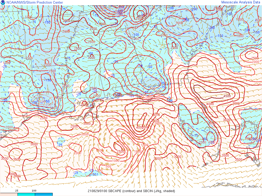
CAPE has increased to 4000 NE of the core.
More than what I have seen in the forecasts
More than what I have seen in the forecasts
1 likes

Re: ATL: IDA - Hurricane - Discussion
Shell Mound wrote:https://twitter.com/NowItsMidnight/status/1431764768168333313
Disclaimer: this may or may not be true, but if the latter...how did this end up happening?
Fouchon is insane. It’s restricted now but used to have a cool surfer scene back in the day. It’s the most waterfront industrial area you can imagine hopped up on steroid shots. It’s ultra bright on the darkest, newest moon
Last edited by Steve on Sat Aug 28, 2021 8:31 pm, edited 1 time in total.
0 likes
-
cheezyWXguy

- Category 5

- Posts: 6282
- Joined: Mon Feb 13, 2006 12:29 am
- Location: Dallas, TX
Re: ATL: IDA - Hurricane - Discussion
aspen wrote:My guess for Ida’s intensity when I wake up at like 6 tomorrow morning: 954-958mb and 95-100 kt.
Think it’s gonna reach that point sooner rather than later. That deep convection now completely surrounding the eye is going to transport those stronger winds to the surface much more efficiently.
1 likes
-
Craters
- Category 1

- Posts: 428
- Joined: Sat Aug 24, 2013 2:34 pm
- Location: Alvin, TX (south of Houston)
Re: ATL: IDA - Hurricane - Discussion
gatorcane wrote:PandaCitrus wrote:https://twitter.com/btangyWx/status/1431719808668782597
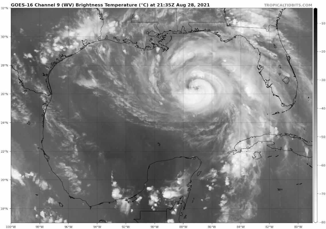
You can see the upper-level low spinning in the Western Gulf (25N, 95W) in this water vapor loop. Look for the counter-clockwise spin:
https://i.postimg.cc/NMRd2BG6/goes16-wv-mid-gom.gif
I know that low was in the Gulf even before Ida formed, but is it possible that it's still there because it's basically being forced to exist by the outflows from Nora and Ida? Looks like it's trapped, and nothing else could really be there between two anticyclones except for a low, right?
1 likes
Nothing that I post here should ever be treated as a forecast or anything resembling one. Please check with your local NWS office or the NHC for forecasts, watches, and warnings.


Re: ATL: IDA - Hurricane - Discussion
Sure looks to be getting it's act together, even if it is gradually intensifying, wouldn't be at all surprised to see it at 110-115kt in the next 8 hours

0 likes
Once I see the REDS and GREENS Converge on a Base Velocity. ... I'm There!!
This is NOT an Official Forecast....Just my Opinion. For official information, please refer to the NHC and NWS products.
HIGHLIGHTS : '13 El Reno Tornado : 2013 Storm Chaser Tour, Joaquin; SC flood event, Matthew '16, Lowcountry Snow storm Jan '18
This is NOT an Official Forecast....Just my Opinion. For official information, please refer to the NHC and NWS products.
HIGHLIGHTS : '13 El Reno Tornado : 2013 Storm Chaser Tour, Joaquin; SC flood event, Matthew '16, Lowcountry Snow storm Jan '18
-
Chris_in_Tampa
- Category 5
- Posts: 5101
- Age: 42
- Joined: Thu Jun 21, 2007 11:06 pm
- Location: Tampa, Florida, USA
- Contact:
Re: ATL: IDA - Hurricane - Discussion
catskillfire51 wrote:tolakram wrote:https://i.imgur.com/27hnUPX.png
Does the track seem like it missed the eye or is that just a plotting error?
Closeup of NOAA recon with satellite imagery at 9:26pm EDT. (https://realearth.ssec.wisc.edu/)

NOAA recon plane location as at 9:14pm EDT, zoomed out with satellite imagery from 9:11pm EDT:

0 likes

Re: ATL: IDA - Hurricane - Discussion
GCANE wrote:RAP forecast at landfall tomorrow afternoon.
No convective inhibition but moving into drier mid-level air.
Not too sure this will be intensifying at landfall.
[url]https://i.postimg.cc/yNczzsKd/RAP-255-2021082823-F18-29-0000-N-91-0000-W.png [/url]
May be ready for an eyewall replacement cycle by then, at least the eye is fairly small but I don't want to get my hopes up now that its down in the 960's.
1 likes
-
Nate-Gillson
- Tropical Storm

- Posts: 133
- Age: 40
- Joined: Sun Aug 22, 2004 8:27 pm
- Location: Cedar Rapids, Iowa
Re: ATL: IDA - Hurricane - Discussion
Oh yeah, I just realized that Ida is forecast to make landfall in the early afternoon tomorrow. I thought it would be during the nighttime. Hopefully no strong cat 3 let alone cat 4.
0 likes
Re: ATL: IDA - Hurricane - Discussion
New tower going up now directly opposite to the fast moving tower.
This could be the start of RI.
This could be the start of RI.
6 likes
-
gatorcane

- S2K Supporter
- Posts: 23708
- Age: 48
- Joined: Sun Mar 13, 2005 3:54 pm
- Location: Boca Raton, FL
Re: ATL: IDA - Hurricane - Discussion
Here she goes, look at that deep convection which was on the south side wrapping around to the north. 
Pressure falls and wind speed increases will be the result.
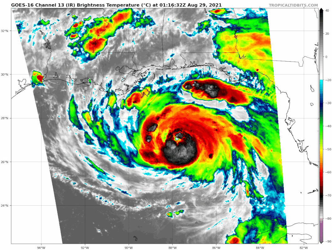
Pressure falls and wind speed increases will be the result.
4 likes
-
LSU2001
- S2K Supporter
- Posts: 1711
- Age: 58
- Joined: Sat Sep 11, 2004 11:01 pm
- Location: Cut Off, Louisiana
Re: ATL: IDA - Hurricane - Discussion
That tweet about Fourchon is probably correct. There a quite a number of boats there that have been mothballed for several years due to the slow down in offshore oil drilling. Most of those boats are not even operable at this point. It would take a good bit of time and effort just to get the engines started. I imagine they will stay there for the duration unless they break loose and end up in the mArsh.
I’m also worried about the loft boat city they have parked just east of Fourchon about 2 miles south of Timbalier island. They have been there several years as well and I would bet most of them are inoperable as well. They are sitting in about 40 feet of water with the deck jacked up well above the surface but with maximum waves being forecast at 70 feet I imagine some will be flipped over come Monday morning
I’m also worried about the loft boat city they have parked just east of Fourchon about 2 miles south of Timbalier island. They have been there several years as well and I would bet most of them are inoperable as well. They are sitting in about 40 feet of water with the deck jacked up well above the surface but with maximum waves being forecast at 70 feet I imagine some will be flipped over come Monday morning
4 likes
Personal Forecast Disclaimer:
The posts in this forum are NOT official forecast and should not be used as such. They are NOT endorsed by any professional institution or storm2k.org. For official information, please refer to the NHC and NWS products.
The posts in this forum are NOT official forecast and should not be used as such. They are NOT endorsed by any professional institution or storm2k.org. For official information, please refer to the NHC and NWS products.

Re: ATL: IDA - Hurricane - Discussion
GCANE wrote:New tower going up now directly opposite to the fast moving tower.
This could be the start of RI.
The double fists are back.
4 likes
Igor 2010, Sandy 2012, Fay 2014, Gonzalo 2014, Joaquin 2015, Nicole 2016, Humberto 2019, Imelda 2025
I am only a tropical weather enthusiast. My predictions are not official and may or may not be backed by sound meteorological data. For official information, please refer to the NHC and NWS products.
I am only a tropical weather enthusiast. My predictions are not official and may or may not be backed by sound meteorological data. For official information, please refer to the NHC and NWS products.

Re: ATL: IDA - Hurricane - Discussion
gatorcane wrote:Here she goes, look at that deep convection which was on the south side wrapping around to the north.
Pressure falls and wind speed increases will be the result.
https://i.postimg.cc/FRRJ2Q1y/goes16-ir-goes16-meso1.gif
Upshear convective symmetrization during the DMAX is always a good time.
0 likes
Very useful information on the Dvorak Technique --
https://severe.worldweather.wmo.int/TCF ... kBeven.pdf
https://severe.worldweather.wmo.int/TCF ... kBeven.pdf
-
SEASON_CANCELED

- Category 3

- Posts: 887
- Joined: Mon Jul 06, 2009 5:17 am
- Location: 8 Bit Charlie Sheen
Re: ATL: IDA - Hurricane - Discussion
gatorcane wrote:Here she goes, look at that deep convection which was on the south side wrapping around to the north.
Pressure falls and wind speed increases will be the result.
https://i.postimg.cc/FRRJ2Q1y/goes16-ir-goes16-meso1.gif
Look at the band to the north, the towers
Everytime I see a hurricane bands get these towers the Rapid Intensification is incredible. Its not 20-30 knots, it ends up being a 40+ knot upgrade in the span of a day.
Hope i am wrong
0 likes
i am a big stupid ugly moron with an ugly face and a big butt and my butt stinks and i like to kiss my own butt
-
SunnyThoughts
- Category 5
- Posts: 2263
- Joined: Wed Jul 09, 2003 12:42 pm
- Location: Pensacola, Florida
Re: ATL: IDA - Hurricane - Discussion
I have no doubt she's strengthening now...and probably at a pretty good rate. Problem is we don't have another recon plane for almost 6 hours. Unacceptable. this close to landfall. Sorry, but im so frustrated at this happening all too often.
8 likes
Who is online
Users browsing this forum: No registered users and 28 guests