ATL: SAM - Models
Moderator: S2k Moderators
-
ElectricStorm

- Category 5

- Posts: 5147
- Age: 25
- Joined: Tue Aug 13, 2019 11:23 pm
- Location: Norman, OK
Re: ATL: INVEST 98L - Models
Looks like it misses the islands but most of the models are showing a strong hurricane near the islands at some point so this could be a problem
0 likes
B.S Meteorology, University of Oklahoma '25
Please refer to the NHC, NWS, or SPC for official information.
Please refer to the NHC, NWS, or SPC for official information.
-
Blown Away

- S2K Supporter

- Posts: 10253
- Joined: Wed May 26, 2004 6:17 am
Re: ATL: INVEST 98L - Models

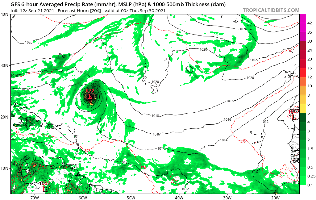
GFS 18z+186... Major cane passing just N of the Caribbean, large SW shift at this point from 12z...
0 likes
Hurricane Eye Experience: David 79, Irene 99, Frances 04, Jeanne 04, Wilma 05… Hurricane Brush Experience: Andrew 92, Erin 95, Floyd 99, Matthew 16, Irma 17, Ian 22, Nicole 22…
-
Iceresistance

- Category 5
- Posts: 9592
- Age: 22
- Joined: Sat Oct 10, 2020 9:45 am
- Location: Tecumseh, OK/Norman, OK
Re: ATL: INVEST 98L - Models
aspen wrote:tolakram wrote:https://i.imgur.com/Ay4Fh1X.png
Where can I find the hi-res Euro runs?
Pivotal Weather also has the High-Res Euro runs . . .
0 likes
Bill 2015 & Beta 2020
Winter 2020-2021
All observations are in Tecumseh, OK unless otherwise noted.
Winter posts are focused mainly for Oklahoma & Texas.
Take any of my forecasts with a grain of salt, refer to the NWS, SPC, and NHC for official information
Never say Never with weather! Because ANYTHING is possible!
Winter 2020-2021
All observations are in Tecumseh, OK unless otherwise noted.
Winter posts are focused mainly for Oklahoma & Texas.
Take any of my forecasts with a grain of salt, refer to the NWS, SPC, and NHC for official information
Never say Never with weather! Because ANYTHING is possible!
-
toad strangler

- S2K Supporter
- Posts: 4546
- Joined: Sun Jul 28, 2013 3:09 pm
- Location: Earth
- Contact:
Re: ATL: INVEST 98L - Models
Teban54 wrote:toad strangler wrote:18z GFS is a good jog further SW than 12z but the 500mb map screams easy re-curve before affecting even the N Lesser Antilles. PArt of larger trend though? We shall see.skyline385 wrote:The ridge is just beginning to build and its already so much SW, good chance of a CONUS hit this run probably
The duality of S2K.
Pretty sure my comment about this particular run will be correct.
0 likes
My Weather Station
https://www.wunderground.com/dashboard/pws/KFLPORTS603
https://www.wunderground.com/dashboard/pws/KFLPORTS603

Re: ATL: INVEST 98L - Models
The low is cutting off heading SW and the ridge is building in. 
0 likes
The following post is NOT an official forecast and should not be used as such. It is just the opinion of the poster and may or may not be backed by sound meteorological data. It is NOT endorsed by any professional institution including storm2k.org For Official Information please refer to the NHC and NWS products.
-
grapealcoholic
- Category 2

- Posts: 703
- Joined: Tue Aug 10, 2021 3:26 pm

-
Blown Away
- S2K Supporter
- Posts: 10253
- Joined: Wed May 26, 2004 6:17 am
Re: ATL: INVEST 98L - Models

SW Trending...
0 likes
Hurricane Eye Experience: David 79, Irene 99, Frances 04, Jeanne 04, Wilma 05… Hurricane Brush Experience: Andrew 92, Erin 95, Floyd 99, Matthew 16, Irma 17, Ian 22, Nicole 22…

-
Iceresistance
- Category 5
- Posts: 9592
- Age: 22
- Joined: Sat Oct 10, 2020 9:45 am
- Location: Tecumseh, OK/Norman, OK
Re: ATL: INVEST 98L - Models
InfernoFlameCat wrote:When the HWRF gets bullish, Eh. When the ECMWF gets bullish,

You may have heard this:
GFS goes crazy: don't expect it to be really crazy.
Euro goes crazy: Get Ready!
1 likes
Bill 2015 & Beta 2020
Winter 2020-2021
All observations are in Tecumseh, OK unless otherwise noted.
Winter posts are focused mainly for Oklahoma & Texas.
Take any of my forecasts with a grain of salt, refer to the NWS, SPC, and NHC for official information
Never say Never with weather! Because ANYTHING is possible!
Winter 2020-2021
All observations are in Tecumseh, OK unless otherwise noted.
Winter posts are focused mainly for Oklahoma & Texas.
Take any of my forecasts with a grain of salt, refer to the NWS, SPC, and NHC for official information
Never say Never with weather! Because ANYTHING is possible!
-
BensonTCwatcher

- Category 5
- Posts: 1050
- Joined: Sat Aug 28, 2004 10:11 pm
- Location: Southport NC
Re: ATL: INVEST 98L - Models
Have to see where this ridge builds back - may be overdone over 200 hours. But it's getting interesting from run to run
0 likes
-
grapealcoholic
- Category 2
- Posts: 703
- Joined: Tue Aug 10, 2021 3:26 pm
Re: ATL: INVEST 98L - Models
Storm is clearing a path to CONUS. Looks determined to close off that trough

1 likes
Re: ATL: INVEST 98L - Models
It could escape on this run but the trend is very eye opening.
0 likes
The following post is NOT an official forecast and should not be used as such. It is just the opinion of the poster and may or may not be backed by sound meteorological data. It is NOT endorsed by any professional institution including storm2k.org For Official Information please refer to the NHC and NWS products.
-
Category5Kaiju

- Category 5
- Posts: 4335
- Joined: Thu Dec 24, 2020 12:45 pm
- Location: Seattle during the summer, Phoenix during the winter
Re: ATL: INVEST 98L - Models
It looks like Eric Webb's concerned tweet in July about the Canadian Ridge being anomalously strong and potentially a problem in ASO for the landmasses may have had some validity to it...
0 likes
Unless explicitly stated, all information in my posts is based on my own opinions and observations. Tropical storms and hurricanes can be extremely dangerous. Refer to an accredited weather research agency or meteorologist if you need to make serious decisions regarding an approaching storm.

Re: ATL: INVEST 98L - Models
grapealcoholic wrote:PV shredder inbound
https://www.tropicaltidbits.com/analysis/models/gfs/2021092118/gfs_pv355K_atl_34.png
How is that 1019mb “low” even a low pressure area? Shouldn’t it be marked with an H instead?
Also the blue PV ring around 98L looks very conducive for intensification…until the trough erodes it.
0 likes
Irene '11 Sandy '12 Hermine '16 5/15/2018 Derecho Fay '20 Isaias '20 Elsa '21 Henri '21 Ida '21
I am only a meteorology enthusiast who knows a decent amount about tropical cyclones. Look to the professional mets, the NHC, or your local weather office for the best information.
I am only a meteorology enthusiast who knows a decent amount about tropical cyclones. Look to the professional mets, the NHC, or your local weather office for the best information.
Re: ATL: INVEST 98L - Models
In the end, GFS still safely recurves, yet is also hundreds of miles SW of previous run. So, everybody's right and everybody's wrong. Also, we're talking 7-10 days out, so we still know nothing
0 likes
-
skyline385

- Category 5
- Posts: 2728
- Age: 35
- Joined: Wed Aug 26, 2020 11:15 pm
- Location: Houston TX
Re: ATL: INVEST 98L - Models
The ridge was a bit weaker this run because of the low coming in...
0 likes
-
grapealcoholic
- Category 2
- Posts: 703
- Joined: Tue Aug 10, 2021 3:26 pm
Re: ATL: INVEST 98L - Models
If that cutoff to its SW is any stronger it probably gets to CONUS
0 likes
-
Iceresistance
- Category 5
- Posts: 9592
- Age: 22
- Joined: Sat Oct 10, 2020 9:45 am
- Location: Tecumseh, OK/Norman, OK
Re: ATL: INVEST 98L - Models
aspen wrote:grapealcoholic wrote:PV shredder inbound
https://www.tropicaltidbits.com/analysis/models/gfs/2021092118/gfs_pv355K_atl_34.png
How is that 1019mb “low” even a low pressure area? Shouldn’t it be marked with an H instead?
Also the blue PV ring around 98L looks very conducive for intensification…until the trough erodes it.
Strange . . . I've once spotted a 1012 MB 'H' on the HWRF model, & I was like "What?"
0 likes
Bill 2015 & Beta 2020
Winter 2020-2021
All observations are in Tecumseh, OK unless otherwise noted.
Winter posts are focused mainly for Oklahoma & Texas.
Take any of my forecasts with a grain of salt, refer to the NWS, SPC, and NHC for official information
Never say Never with weather! Because ANYTHING is possible!
Winter 2020-2021
All observations are in Tecumseh, OK unless otherwise noted.
Winter posts are focused mainly for Oklahoma & Texas.
Take any of my forecasts with a grain of salt, refer to the NWS, SPC, and NHC for official information
Never say Never with weather! Because ANYTHING is possible!

Re: ATL: INVEST 98L - Models
While it recurves from the CONUS, 18z GFS is almost 500 miles further SW than 12z at +246 and looks like it'll almost directly hit Bermuda in this run.

0 likes
Who is online
Users browsing this forum: No registered users and 28 guests