ATL: IDA - Remnants - Discussion
Moderator: S2k Moderators
-
HurricaneFrances04
- Category 2

- Posts: 597
- Joined: Mon Jun 25, 2012 8:09 am
- Location: Fort Lauderdale, Florida
Re: ATL: IDA - Hurricane - Discussion
Don’t think that last dropsonde made it to the surface?
0 likes
-
grapealcoholic
- Category 2
- Posts: 703
- Joined: Tue Aug 10, 2021 3:26 pm
-
AJC3

- Admin

- Posts: 4156
- Age: 62
- Joined: Tue Aug 31, 2004 7:04 pm
- Location: Ballston Spa, New York
- Contact:
Re: ATL: IDA - Hurricane - Discussion
PavelGaborik wrote:grapealcoholic wrote:PavelGaborik wrote:
Looks like an EWRC is underway to me.
Looks like a meld
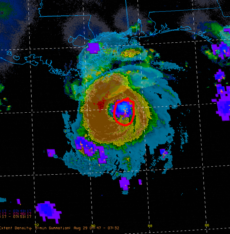
Radar indicates a classic EWRC is underway.
We'll find out when Recon gets there but I would he extremely shocked if there was no double wind maxima present when they arrive.
This is incorrect. There is no double wind maximum and no well-etsablished moat surrounding the eyewall yet. The bref values in the eyewall have actually increased over the past hour and whatever moat that has tried to form is in the process of coalescing with the eyewall. This could change, but it's premature to say an EWRC has started yet.
11 likes
-
Chris_in_Tampa
- Category 5

- Posts: 5101
- Age: 42
- Joined: Thu Jun 21, 2007 11:06 pm
- Location: Tampa, Florida, USA
- Contact:
Re: ATL: IDA - Hurricane - Discussion
HurricaneFrances04 wrote:Don’t think that last dropsonde made it to the surface?
Haven't see the center sonde come across yet.
0 likes
-
MississippiWx

- S2K Supporter

- Posts: 1720
- Joined: Sat Aug 14, 2010 1:44 pm
- Location: Hattiesburg, Mississippi
Re: ATL: IDA - Hurricane - Discussion
The clearing of the eye recently is concerning. While deepening has slowed, it might not be done quite yet.
0 likes
This post is not an official forecast and should not be used as such. It is just the opinion of MississippiWx and may or may not be backed by sound meteorological data. It is not endorsed by any professional institution including storm2k.org. For Official Information please refer to the NHC and NWS products.
-
Chris_in_Tampa
- Category 5
- Posts: 5101
- Age: 42
- Joined: Thu Jun 21, 2007 11:06 pm
- Location: Tampa, Florida, USA
- Contact:
Re: ATL: IDA - Hurricane - Discussion
HurricaneFrances04 wrote:Don’t think that last dropsonde made it to the surface?
Haven't see the center sonde come across yet.
0 likes
-
Dean4Storms
- S2K Supporter
- Posts: 6358
- Age: 63
- Joined: Sun Aug 31, 2003 1:01 pm
- Location: Miramar Bch. FL
Re: ATL: IDA - Hurricane - Discussion
Everybody be kind and mind your manners or you’ll get an EWRC spanking! 
Last edited by Dean4Storms on Sun Aug 29, 2021 4:40 am, edited 1 time in total.
5 likes
-
Blown Away

- S2K Supporter
- Posts: 10253
- Joined: Wed May 26, 2004 6:17 am
Re: ATL: IDA - Hurricane - Discussion
Super impressive on radar, but never could get that nice ring appearance on the IR. These storms always behave a little different.
0 likes
Hurricane Eye Experience: David 79, Irene 99, Frances 04, Jeanne 04, Wilma 05… Hurricane Brush Experience: Andrew 92, Erin 95, Floyd 99, Matthew 16, Irma 17, Ian 22, Nicole 22…
-
Stormgodess

- Category 1

- Posts: 316
- Joined: Mon Sep 14, 2020 1:31 am
Re: ATL: IDA - Hurricane - Discussion (Update: Now Category 4)
LARanger wrote:Okay, so basically at this point I'm really considering the idea I'm gonna bounce if this goes 5. Inland I may be, but there's a fighting chance the eye goes over me and I'm not terribly interested in eating that in both directions. I ate about 100 sustained-wind for Katrina in or damn near the eastern eyewall and I wouldn't want to exceed that pleasure . . . though as I say this and note the details, it was a ~15mph forward-motion storm also and, well, huh . . . I dunno, I still don't like it.
It was one thing when it was to the west (even skirting me), it'd be another thing to the east, but I don't know how I feel about an eye trip, especially if this thing goes 5 and sustains more energy when it gets here. I might could live with 100mph . . . but I sure liked it better when it was gonna be 45-60 on me.
Has the track changed again? Where is it heading now? I've been having the same thoughts just being east of the last track I saw.. But at this point people are likely pouring out of New Orleans? I worry about getting stuck in traffic in it?
0 likes
-
AJC3
- Admin
- Posts: 4156
- Age: 62
- Joined: Tue Aug 31, 2004 7:04 pm
- Location: Ballston Spa, New York
- Contact:
Re: ATL: IDA - Hurricane - Discussion
And let's avoid taking any swipes at one another. I don't feel like zapping any more posts like I just had to do. Thanks.
8 likes
-
Stormgodess
- Category 1
- Posts: 316
- Joined: Mon Sep 14, 2020 1:31 am
Re: ATL: IDA - Hurricane - Discussion (Update: Now Category 4)
LARanger wrote:Okay, so basically at this point I'm really considering the idea I'm gonna bounce if this goes 5. Inland I may be, but there's a fighting chance the eye goes over me and I'm not terribly interested in eating that in both directions. I ate about 100 sustained-wind for Katrina in or damn near the eastern eyewall and I wouldn't want to exceed that pleasure . . . though as I say this and note the details, it was a ~15mph forward-motion storm also and, well, huh . . . I dunno, I still don't like it.
It was one thing when it was to the west (even skirting me), it'd be another thing to the east, but I don't know how I feel about an eye trip, especially if this thing goes 5 and sustains more energy when it gets here. I might could live with 100mph . . . but I sure liked it better when it was gonna be 45-60 on me.
Has the track changed again? Where is it heading now? I've been having the same thoughts just being east of the last track I saw.. But at this point people are likely pouring out of New Orleans? I worry about getting stuck in traffic in it?
0 likes

Re: ATL: IDA - Hurricane - Discussion
Dean4Storms wrote:Everybody be kind and mind your manners or you’ll get an EWRC spanking!
You mean a meld spanking I presume
2 likes
-
Chris_in_Tampa
- Category 5
- Posts: 5101
- Age: 42
- Joined: Thu Jun 21, 2007 11:06 pm
- Location: Tampa, Florida, USA
- Contact:
Re: ATL: IDA - Hurricane - Discussion
For really raw sonde data you can look here:
https://seb.noaa.gov/pub/flight/aamps_i ... 0210829I1/
I'll wait for message that comes across though.
https://seb.noaa.gov/pub/flight/aamps_i ... 0210829I1/
I'll wait for message that comes across though.
0 likes
-
PavelGaborik
- Tropical Depression

- Posts: 81
- Joined: Thu Oct 06, 2016 11:13 pm
Re: ATL: IDA - Hurricane - Discussion
AJC3 wrote:PavelGaborik wrote:grapealcoholic wrote:Looks like a meld
Radar indicates a classic EWRC is underway.
We'll find out when Recon gets there but I would he extremely shocked if there was no double wind maxima present when they arrive.
This is incorrect. There is no double wind maximum and no well-etsablished moat surrounding the eyewall yet. The bref values in the eyewall have actually increased over the past hour and whatever moat that has tried to form is in the process of coalescing with the eyewall. This could change, but it's premature to say an EWRC has started yet.
The outer banding/moating that was occuring diminished/"merged" for lack of a better term with the inner core, there was definitely potential for an EWRC prior to that, it certainly didn't transpire though.
0 likes
-
Dean4Storms
- S2K Supporter
- Posts: 6358
- Age: 63
- Joined: Sun Aug 31, 2003 1:01 pm
- Location: Miramar Bch. FL
Re: ATL: IDA - Hurricane - Discussion
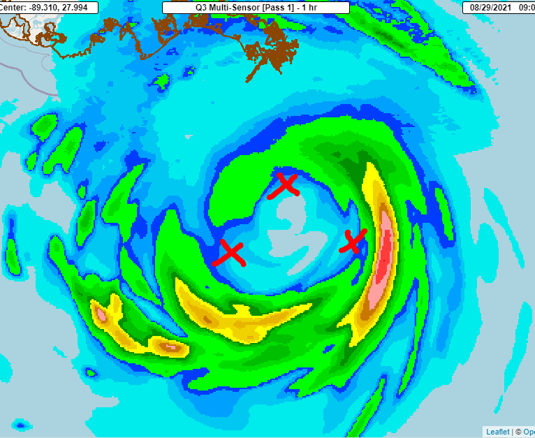
Is it my weary eyes or does it appear that the eye on radar from KLIX is contracting, getting smaller?
0 likes
-
AlphaToOmega
- Category 5
- Posts: 1448
- Joined: Sat Jun 26, 2021 10:51 am
- Location: Somewhere in Massachusetts
Re: ATL: IDA - Hurricane - Discussion
Key messages regarding Ida
Key Messages:
1. There is a danger of life-threatening storm surge inundation
Sunday along the coasts of Louisiana, Mississippi, and Alabama
within the Storm Surge Warning area. Extremely life-threatening
inundation of 9 feet or greater above ground level is possible
somewhere within the area from Morgan City, Louisiana, to the coast
of Mississippi. Overtopping of local levees outside of the Hurricane
and Storm Damage Risk Reduction System is possible where local
inundation values may be higher. Interests throughout the warning
area should follow any advice given by local officials.
2. Ida is expected to be an extremely dangerous major hurricane when
it reaches the coast of southeastern Louisiana. Hurricane-force
winds are expected Sunday in portions of the Hurricane Warning area
along the Louisiana coast, including metropolitan New Orleans, with
potentially catastrophic wind damage possible where the core of Ida
moves onshore. Actions to protect life and property should be rushed
to completion in the warning area.
3. Damaging winds, especially in gusts, will spread inland near the
track of the center of Ida across portions of southeastern Louisiana
and southwestern Mississippi Sunday night and early Monday. These
winds will likely lead to widespread tree damage and power outages.
4. Ida will produce heavy rainfall today through Monday across the
central Gulf Coast from southeastern Louisiana, coastal Mississippi,
to far southwestern Alabama resulting in considerable to
life-threatening flash and urban flooding and significant riverine
flooding impacts. As Ida moves inland, significant flooding impacts
are possible across portions of the Lower Mississippi, Tennessee,
and Ohio Valleys through Wednesday.
0 likes

-
Keldeo1997
- Category 2
- Posts: 688
- Joined: Fri Oct 11, 2019 11:35 pm


Re: ATL: IDA - Hurricane - Discussion
Live traffic cams for La on I-10
https://calcasieu.info/live-traffic-cam ... louisiana/
https://calcasieu.info/live-traffic-cam ... louisiana/
0 likes
-
AJC3
- Admin
- Posts: 4156
- Age: 62
- Joined: Tue Aug 31, 2004 7:04 pm
- Location: Ballston Spa, New York
- Contact:
Re: ATL: IDA - Hurricane - Discussion
PavelGaborik wrote:AJC3 wrote:PavelGaborik wrote:
Radar indicates a classic EWRC is underway.
We'll find out when Recon gets there but I would he extremely shocked if there was no double wind maxima present when they arrive.
This is incorrect. There is no double wind maximum and no well-etsablished moat surrounding the eyewall yet. The bref values in the eyewall have actually increased over the past hour and whatever moat that has tried to form is in the process of coalescing with the eyewall. This could change, but it's premature to say an EWRC has started yet.
The outer banding/moating that was occuring diminished/"merged" for lack of a better term with the inner core, there was definitely potential for an EWRC prior to that, it certainly didn't transpire though.
Exactly. I mentioned in a previous post that this type of thing has been going on for the better part of 4 hours now, but whenever gaps have occured they have quickly filled in. To consitute a moat, you'd have to see a well-defined echo-free ring persist around the eyewall. An ERWC could still commence before landfall. However if one does, unless it starts within the next few hours, I doubt it would have time to complete.
0 likes
Who is online
Users browsing this forum: No registered users and 50 guests