ATL: SAM - Models
Moderator: S2k Moderators
Re: ATL: INVEST 98L - Models
Bermuda barely avoids a direct hit as 98L passes to the west. Looks like 98L is starting to bend to the west as it passes by Bermuda.
Last edited by IcyTundra on Tue Sep 21, 2021 5:54 pm, edited 1 time in total.
0 likes
-
Keldeo1997
- Category 2

- Posts: 688
- Joined: Fri Oct 11, 2019 11:35 pm
-
skyline385

- Category 5

- Posts: 2728
- Age: 35
- Joined: Wed Aug 26, 2020 11:15 pm
- Location: Houston TX
Re: ATL: INVEST 98L - Models
toad strangler wrote:Teban54 wrote:toad strangler wrote:18z GFS is a good jog further SW than 12z but the 500mb map screams easy re-curve before affecting even the N Lesser Antilles. PArt of larger trend though? We shall see.skyline385 wrote:The ridge is just beginning to build and its already so much SW, good chance of a CONUS hit this run probably
The duality of S2K.
Pretty sure my comment about this particular run will be correct.
You win this round, just barely though
0 likes
-
gatorcane

- S2K Supporter

- Posts: 23708
- Age: 48
- Joined: Sun Mar 13, 2005 3:54 pm
- Location: Boca Raton, FL
Re: ATL: INVEST 98L - Models
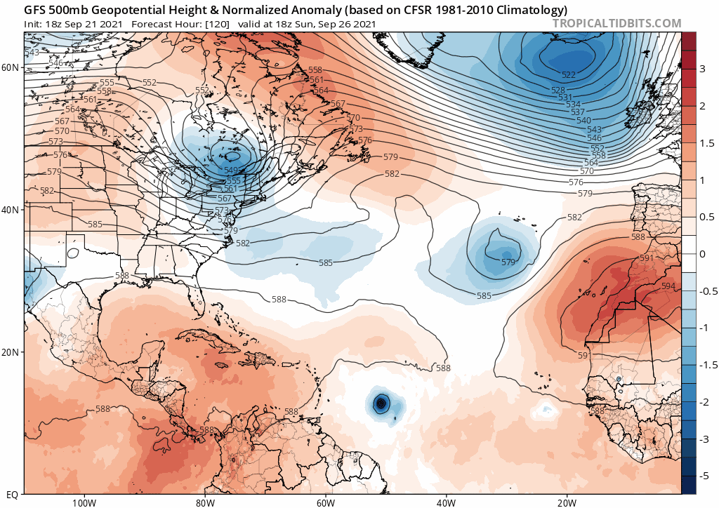
The 18Z GFS from hours 120-258. Closer to the islands yes but that mid to upper-level low in the Bahamas is a major shield from it heading towards Florida or even the CONUS for that matter if that develops.
0 likes
-
Keldeo1997
- Category 2
- Posts: 688
- Joined: Fri Oct 11, 2019 11:35 pm

-
Category5Kaiju

- Category 5
- Posts: 4335
- Joined: Thu Dec 24, 2020 12:45 pm
- Location: Seattle during the summer, Phoenix during the winter
Re: ATL: INVEST 98L - Models
gatorcane wrote:The 18Z GFS from hours 120-258. Closer to the islands yes but that mid to upper-level low in the Bahamas is a major shield from it heading towards Florida or even the CONUS for that matter if that develops.
https://i.postimg.cc/SKv3q2rN/gfs-z500a-Norm-atl-fh120-258.gif
Wait, what the heck? Is that like even possible, for a ridge that strong over Canada to have this storm literally go northward through it?
1 likes
Unless explicitly stated, all information in my posts is based on my own opinions and observations. Tropical storms and hurricanes can be extremely dangerous. Refer to an accredited weather research agency or meteorologist if you need to make serious decisions regarding an approaching storm.
-
Keldeo1997
- Category 2
- Posts: 688
- Joined: Fri Oct 11, 2019 11:35 pm
-
Hypercane_Kyle

- Category 5
- Posts: 3465
- Joined: Sat Mar 07, 2015 7:58 pm
- Location: Cape Canaveral, FL
Re: ATL: INVEST 98L - Models
That GFS run is whack. How does a storm manage to recurve right into a ridge? There's no obvious weakness that I see - just a stout ridge.

EDIT: Ninja'd by Wxtwitter
EDIT: Ninja'd by Wxtwitter
2 likes
My posts are my own personal opinion, defer to the National Hurricane Center (NHC) and other NOAA products for decision making during hurricane season.
-
skyline385
- Category 5
- Posts: 2728
- Age: 35
- Joined: Wed Aug 26, 2020 11:15 pm
- Location: Houston TX
-
supercane4867
- Category 5
- Posts: 4966
- Joined: Wed Nov 14, 2012 10:43 am
Re: ATL: INVEST 98L - Models
Friendly reminder that neither climo nor the GFS can go against the rule of physics as much as they want to
1 likes
Re: ATL: INVEST 98L - Models
The solution the GFS shows isn't that far off for a potential New England landfall.
0 likes
Re: ATL: INVEST 98L - Models
gatorcane wrote:The 18Z GFS from hours 120-258. Closer to the islands yes but that mid to upper-level low in the Bahamas is a major shield from it heading towards Florida or even the CONUS for that matter if that develops.
https://i.postimg.cc/SKv3q2rN/gfs-z500a-Norm-atl-fh120-258.gif
"If it develops" is right. The chances of that ULL sitting right there in that location in 240 hours is quite the longshot
0 likes
-
grapealcoholic
- Category 2
- Posts: 703
- Joined: Tue Aug 10, 2021 3:26 pm


Re: ATL: INVEST 98L - Models
18z HMON continues the trend of slower development, with 98L not attaining consistent TS winds until Saturday morning. It’s a lot further SW on this run as a result. We might start seeing some Maria-like tracks into the east Caribbean in future model runs.
0 likes
Irene '11 Sandy '12 Hermine '16 5/15/2018 Derecho Fay '20 Isaias '20 Elsa '21 Henri '21 Ida '21
I am only a meteorology enthusiast who knows a decent amount about tropical cyclones. Look to the professional mets, the NHC, or your local weather office for the best information.
I am only a meteorology enthusiast who knows a decent amount about tropical cyclones. Look to the professional mets, the NHC, or your local weather office for the best information.
-
SouthFLTropics

- Category 5
- Posts: 4258
- Age: 50
- Joined: Thu Aug 14, 2003 8:04 am
- Location: Port St. Lucie, Florida
Re: ATL: INVEST 98L - Models
Meanwhile, the 18z HWRF is nothing but crickets...

0 likes
Fourth Generation Florida Native
Personal Storm History: David 79, Andrew 92, Erin 95, Floyd 99, Irene 99, Frances 04, Jeanne 04, Wilma 05, Matthew 16, Irma 17, Ian 22, Nicole 22, Milton 24
Personal Storm History: David 79, Andrew 92, Erin 95, Floyd 99, Irene 99, Frances 04, Jeanne 04, Wilma 05, Matthew 16, Irma 17, Ian 22, Nicole 22, Milton 24
Re: ATL: INVEST 98L - Models
SouthFLTropics wrote:Meanwhile, the 18z HWRF is nothing but crickets...
https://i.imgur.com/PRptQIG.png
Toss this HWRF run out has it near 5N in 72 HR it is near 10 N right now.
0 likes
Re: ATL: INVEST 98L - Models
SouthFLTropics wrote:Meanwhile, the 18z HWRF is nothing but crickets...
https://i.imgur.com/PRptQIG.png
It gets stuck on one spot on the map. Toss this run out; it sometimes gets stuck (most often the HWRF-P).
0 likes
Irene '11 Sandy '12 Hermine '16 5/15/2018 Derecho Fay '20 Isaias '20 Elsa '21 Henri '21 Ida '21
I am only a meteorology enthusiast who knows a decent amount about tropical cyclones. Look to the professional mets, the NHC, or your local weather office for the best information.
I am only a meteorology enthusiast who knows a decent amount about tropical cyclones. Look to the professional mets, the NHC, or your local weather office for the best information.
-
skyline385
- Category 5
- Posts: 2728
- Age: 35
- Joined: Wed Aug 26, 2020 11:15 pm
- Location: Houston TX
Re: ATL: INVEST 98L - Models
aspen wrote:SouthFLTropics wrote:Meanwhile, the 18z HWRF is nothing but crickets...
https://i.imgur.com/PRptQIG.png
It gets stuck on one spot on the map. Toss this run out; it sometimes gets stuck (most often the HWRF-P).
Uhm isnt the HWRF-P (since P is Parent and not Parallel) the same as HWRF? The results are also the same for both...
0 likes
Re: ATL: INVEST 98L - Models
skyline385 wrote:aspen wrote:SouthFLTropics wrote:Meanwhile, the 18z HWRF is nothing but crickets...
https://i.imgur.com/PRptQIG.png
It gets stuck on one spot on the map. Toss this run out; it sometimes gets stuck (most often the HWRF-P).
Uhm isnt the HWRF-P (afaik P is Parent and not Parallel) the same as HWRF?
Due to its wider field of view, it likes to get its focus stuck on whatever low pressure area happens to be even a tiny bit deeper than the disturbance it’s supposed to be focusing on. There’s been this low over central Africa that the HWRF-P has gotten stuck on for many early runs of Peter and 98L.
1 likes
Irene '11 Sandy '12 Hermine '16 5/15/2018 Derecho Fay '20 Isaias '20 Elsa '21 Henri '21 Ida '21
I am only a meteorology enthusiast who knows a decent amount about tropical cyclones. Look to the professional mets, the NHC, or your local weather office for the best information.
I am only a meteorology enthusiast who knows a decent amount about tropical cyclones. Look to the professional mets, the NHC, or your local weather office for the best information.
-
skyline385
- Category 5
- Posts: 2728
- Age: 35
- Joined: Wed Aug 26, 2020 11:15 pm
- Location: Houston TX
Re: ATL: INVEST 98L - Models
aspen wrote:skyline385 wrote:aspen wrote:It gets stuck on one spot on the map. Toss this run out; it sometimes gets stuck (most often the HWRF-P).
Uhm isnt the HWRF-P (afaik P is Parent and not Parallel) the same as HWRF?
Due to its wider field of view, it likes to get its focus stuck on whatever low pressure area happens to be even a tiny bit deeper than the disturbance it’s supposed to be focusing on. There’s been this low over central Africa that the HWRF-P has gotten stuck on for many early runs of Peter and 98L.
So its a different run of the HWRF then?
0 likes
Who is online
Users browsing this forum: No registered users and 43 guests