ATL: FRED - Post-Tropical - Discussion
Moderator: S2k Moderators
-
Blown Away

- S2K Supporter

- Posts: 10253
- Joined: Wed May 26, 2004 6:17 am
Re: ATL: INVEST 94L - Discussion
Kinda reminds me of Elsa, small fragile circulation that could ramp up quick and die off just as fast.
0 likes
Hurricane Eye Experience: David 79, Irene 99, Frances 04, Jeanne 04, Wilma 05… Hurricane Brush Experience: Andrew 92, Erin 95, Floyd 99, Matthew 16, Irma 17, Ian 22, Nicole 22…
-
Shell Mound
- Category 5

- Posts: 2432
- Age: 33
- Joined: Thu Sep 07, 2017 3:39 pm
- Location: St. Petersburg, FL → Scandinavia
Re: ATL: INVEST 94L - Discussion
Blown Away wrote:Kinda reminds me of Elsa, small fragile circulation that could ramp up quick and die off just as fast.
Like Elsa, 94L also appears to be moving somewhat faster than expected in the short term. This could result in a somewhat weaker system that dies faster.
0 likes
CVW / MiamiensisWx / Shell Mound
The posts in this forum are NOT official forecasts and should not be used as such. They are just the opinion of the poster and may or may not be backed by sound meteorological data. They are NOT endorsed by any professional institution or STORM2K. For official information, please refer to products from the NHC and NWS.

Re: ATL: INVEST 94L - Discussion
Aric Dunn wrote:NDG wrote:Aric Dunn wrote:We have what about 24 hours to barbados.. could see a PTC tonight if convection continues to increase and maintain.
All global models have the vorticity tracking to the north of Barbados, if true they shouldn't see much winds out of it unlike with Elsa.
I Have been discussing this elsewhere. and the models have been showing a wnw/nw sharp motion to occur ... it needs to do that soon.
right now there is no reason for the turn.. and it is chugging West pretty steady.
so barbados is still in the path for now.
it is still E/ESE of barbados. and less than 24 hours away.. going to have a tough time missing it.
https://i.ibb.co/5x1DVtX/LABELS-19700101-000000-127.gif
12z HWRF also shows it tracking north of Barbados.
We shall see.
0 likes
-
Aric Dunn
- Category 5
- Posts: 21238
- Age: 43
- Joined: Sun Sep 19, 2004 9:58 pm
- Location: Ready for the Chase.
- Contact:
Re: ATL: INVEST 94L - Discussion
NDG wrote:Aric Dunn wrote:NDG wrote:
All global models have the vorticity tracking to the north of Barbados, if true they shouldn't see much winds out of it unlike with Elsa.
I Have been discussing this elsewhere. and the models have been showing a wnw/nw sharp motion to occur ... it needs to do that soon.
right now there is no reason for the turn.. and it is chugging West pretty steady.
so barbados is still in the path for now.
it is still E/ESE of barbados. and less than 24 hours away.. going to have a tough time missing it.
https://i.ibb.co/5x1DVtX/LABELS-19700101-000000-127.gif
12z HWRF also shows it tracking north of Barbados.
We shall see.
Yeah the models keep showing it moving that way.. but it just keeps moving west.. likely just lack of data at this point.
4 likes
Note: If I make a post that is brief. Please refer back to previous posts for the analysis or reasoning. I do not re-write/qoute what my initial post said each time.
If there is nothing before... then just ask
Space & Atmospheric Physicist, Embry-Riddle Aeronautical University,
I believe the sky is falling...
If there is nothing before... then just ask
Space & Atmospheric Physicist, Embry-Riddle Aeronautical University,
I believe the sky is falling...

-
AtlanticWind

- S2K Supporter
- Posts: 1898
- Age: 67
- Joined: Sun Aug 08, 2004 9:57 pm
- Location: Plantation,Fla
Re: ATL: INVEST 94L - Discussion
From NWS miami
South Florida today.
LONG TERM (Monday Night through Saturday)...
In general, lower through middle tropospheric ridging will prevail
during much of the week. Aloft, a TUTT is forecast to gradually move
from the Bahamas to an area generally over the Florida peninsula
late in the week. Low-level steering flow will remain mostly E or SE
through the period, resulting in an overall seabreeze pattern
favoring the most robust convection across the interior and
southwest Florida. Subsidence and and dry air associated with the
TUTT may limit coverage of storms area-wide on Wednesday and
Thursday, with the potential for more widespread storm coverage late
in the week should the TUTT continue into the Gulf. Deterministic
guidance diverges quite a bit late in the week as to the handling of
this TUTT (i.e. moves into the Gulf, meanders over FL, or northeast
across the western Atlantic). The position/strength of the upper low
has the potential to have a substantial influence on any tropical
wave that may develop and move into the western Atlantic (see NHC`s
TWO). For example, a slower moving low could provide suppressive
upper-level shear over the western Atlantic, while a more
progressive system could make way for weaker upper-level winds
supportive of development. For now, ensemble support for any sort of
tropical development is minimal at best and folks should continue
with their typical level of tropical season vigilance and
preparedness.
7 likes
-
Shell Mound
- Category 5
- Posts: 2432
- Age: 33
- Joined: Thu Sep 07, 2017 3:39 pm
- Location: St. Petersburg, FL → Scandinavia
Re: ATL: INVEST 94L - Discussion
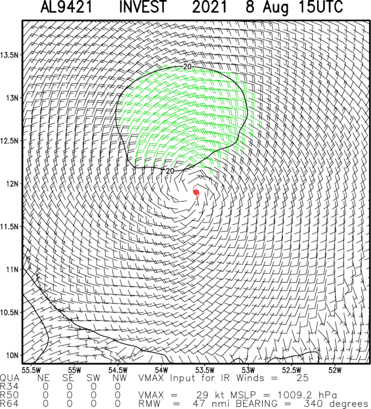
Based on visible imagery, the prototypal “LLC” has moved a full degree westward (53.5°W → 54.5°W) in less than five hours, between 12:15Z and 17:05Z. The 12Z HWRF showed 94L reaching 53.8°W by 18Z today, so it clearly far too slow. This has implications for the intensity, given that a faster 94L in the short term is more likely to be disheveled structurally, and thus less able to become vertically stacked. Virtually all of the models are currently showing a track too far to the north in the short term. Expect downward adjustments to the short-term intensity and southward adjustments to the short-term track.
Last edited by Shell Mound on Sun Aug 08, 2021 12:35 pm, edited 1 time in total.
0 likes
CVW / MiamiensisWx / Shell Mound
The posts in this forum are NOT official forecasts and should not be used as such. They are just the opinion of the poster and may or may not be backed by sound meteorological data. They are NOT endorsed by any professional institution or STORM2K. For official information, please refer to products from the NHC and NWS.
-
Stormybajan

- Category 1

- Posts: 453
- Joined: Thu May 20, 2021 3:21 pm
- Location: Windward Islands
Re: ATL: INVEST 94L - Discussion
Aric Dunn wrote:NDG wrote:Aric Dunn wrote:We have what about 24 hours to barbados.. could see a PTC tonight if convection continues to increase and maintain.
All global models have the vorticity tracking to the north of Barbados, if true they shouldn't see much winds out of it unlike with Elsa.
I Have been discussing this elsewhere. and the models have been showing a wnw/nw sharp motion to occur ... it needs to do that soon.
right now there is no reason for the turn.. and it is chugging West pretty steady.
so barbados is still in the path for now.
it is still E/ESE of barbados. and less than 24 hours away.. going to have a tough time missing it.
https://i.ibb.co/5x1DVtX/LABELS-19700101-000000-127.gif
Yep,said it before this is a St.Lucia-Martinque problem I dont see 94L traveling all the way up north to Guadeloupe like models have been showing for quite sometime now. I dont mind though in Barbados we would welcome some rain as the last 2 weeks have been extremely HOT!
5 likes
Sad West Indies and Manchester United fan ⚽️
Re: ATL: INVEST 94L - Discussion
Thought this would happen today.
Recon being tasked.
000
NOUS42 KNHC 081705
REPRPD
WEATHER RECONNAISSANCE FLIGHTS
CARCAH, NATIONAL HURRICANE CENTER, MIAMI, FL.
0105 PM EDT SUN 08 AUGUST 2021
SUBJECT: TROPICAL CYCLONE PLAN OF THE DAY (TCPOD)
VALID 09/1100Z TO 10/1100Z AUGUST 2021
TCPOD NUMBER.....21-069
I. ATLANTIC REQUIREMENTS
1. SUSPECT AREA (EAST OF WINDWARD ISLANDS)
FLIGHT ONE - NOAA 42
A. 10/1300Z
B. NOAA2 01DDA INVEST
C. 10/0830Z
D. 16.5N 63.5W
E. 10/1230Z TO 10/1630Z
F. SFC TO 10,000 FT
2. OUTLOOK FOR SUCCEEDING DAY: BEGIN 6-HRLY FIXES AT 10/2330Z
IF SYSTEM DEVELOPS.
4 likes
-
SFLcane

- S2K Supporter
- Posts: 10281
- Age: 48
- Joined: Sat Jun 05, 2010 1:44 pm
- Location: Lake Worth Florida
Re: ATL: INVEST 94L - Discussion
Up to 40-50%
Last edited by SFLcane on Sun Aug 08, 2021 12:42 pm, edited 1 time in total.
4 likes
-
cycloneye

- Admin

- Posts: 149550
- Age: 69
- Joined: Thu Oct 10, 2002 10:54 am
- Location: San Juan, Puerto Rico
Re: ATL: INVEST 94L - Discussion
An elongated area of low pressure located several hundred miles
east of the Windward Islands continues to produce disorganized
showers and thunderstorms. Environmental conditions are expected
to be favorable to support some gradual development over the next
few days, and this system could become a tropical depression while
it moves west-northwestward at 10 to 15 mph. The disturbance is
forecast to reach portions of the Lesser Antilles late Monday, and
then move near the Virgin Islands and Puerto Rico on Tuesday, and
near Hispaniola around the middle of this week. Interests in those
areas should monitor the progress of this system, as it could bring
locally heavy rainfall and gusty winds to portions of that area.
* Formation chance through 48 hours...medium...40 percent.
* Formation chance through 5 days...medium...50 percent.
5 likes
Visit the Caribbean-Central America Weather Thread where you can find at first post web cams,radars
and observations from Caribbean basin members Click Here
and observations from Caribbean basin members Click Here
-
Shell Mound
- Category 5
- Posts: 2432
- Age: 33
- Joined: Thu Sep 07, 2017 3:39 pm
- Location: St. Petersburg, FL → Scandinavia
Re: ATL: INVEST 94L - Discussion
Aric Dunn wrote:NDG wrote:Aric Dunn wrote:
I Have been discussing this elsewhere. and the models have been showing a wnw/nw sharp motion to occur ... it needs to do that soon.
right now there is no reason for the turn.. and it is chugging West pretty steady.
so barbados is still in the path for now.
it is still E/ESE of barbados. and less than 24 hours away.. going to have a tough time missing it.
https://i.ibb.co/5x1DVtX/LABELS-19700101-000000-127.gif
12z HWRF also shows it tracking north of Barbados.
We shall see.
Yeah the models keep showing it moving that way.. but it just keeps moving west.. likely just lack of data at this point.
A more southerly track would still take 94L toward the Tiburón Peninsula and some of the highest peaks on the island of Hispaniola, which would save South Florida.
0 likes
CVW / MiamiensisWx / Shell Mound
The posts in this forum are NOT official forecasts and should not be used as such. They are just the opinion of the poster and may or may not be backed by sound meteorological data. They are NOT endorsed by any professional institution or STORM2K. For official information, please refer to products from the NHC and NWS.
-
Aric Dunn
- Category 5
- Posts: 21238
- Age: 43
- Joined: Sun Sep 19, 2004 9:58 pm
- Location: Ready for the Chase.
- Contact:
Re: ATL: INVEST 94L - Discussion
If it does not jump up to 14N like the models are showing happening over the next 6 to 12 hours... and it passes over barbados ( which is appears it might) then this could easily pass south of Hispaniola.
1 likes
Note: If I make a post that is brief. Please refer back to previous posts for the analysis or reasoning. I do not re-write/qoute what my initial post said each time.
If there is nothing before... then just ask
Space & Atmospheric Physicist, Embry-Riddle Aeronautical University,
I believe the sky is falling...
If there is nothing before... then just ask
Space & Atmospheric Physicist, Embry-Riddle Aeronautical University,
I believe the sky is falling...
-
Aric Dunn
- Category 5
- Posts: 21238
- Age: 43
- Joined: Sun Sep 19, 2004 9:58 pm
- Location: Ready for the Chase.
- Contact:
Re: ATL: INVEST 94L - Discussion
Shell Mound wrote:Aric Dunn wrote:NDG wrote:
12z HWRF also shows it tracking north of Barbados.
We shall see.
Yeah the models keep showing it moving that way.. but it just keeps moving west.. likely just lack of data at this point.
A more southerly track would still take 94L toward the Tiburón Peninsula and some of the highest peaks on the island of Hispaniola, which would save South Florida.
save south florida ? many system have crossed those regions and come out the other side to deepen again..
4 likes
Note: If I make a post that is brief. Please refer back to previous posts for the analysis or reasoning. I do not re-write/qoute what my initial post said each time.
If there is nothing before... then just ask
Space & Atmospheric Physicist, Embry-Riddle Aeronautical University,
I believe the sky is falling...
If there is nothing before... then just ask
Space & Atmospheric Physicist, Embry-Riddle Aeronautical University,
I believe the sky is falling...
-
AlphaToOmega
- Category 5
- Posts: 1448
- Joined: Sat Jun 26, 2021 10:51 am
- Location: Somewhere in Massachusetts
Re: ATL: INVEST 94L - Discussion
Showers are increasing during diurnal minimum. This is likely to become a tropical cyclone.
2 likes
-
Shell Mound
- Category 5
- Posts: 2432
- Age: 33
- Joined: Thu Sep 07, 2017 3:39 pm
- Location: St. Petersburg, FL → Scandinavia
Re: ATL: INVEST 94L - Discussion
Aric Dunn wrote:Shell Mound wrote:Aric Dunn wrote:
Yeah the models keep showing it moving that way.. but it just keeps moving west.. likely just lack of data at this point.
A more southerly track would still take 94L toward the Tiburón Peninsula and some of the highest peaks on the island of Hispaniola, which would save South Florida.
save south florida ? many system have crossed those regions and come out the other side to deepen again..
Those systems were larger than 94L. A small system such as 94L would likely struggle to contend with the mountainous terrain and lose its stacked circulation.
0 likes
CVW / MiamiensisWx / Shell Mound
The posts in this forum are NOT official forecasts and should not be used as such. They are just the opinion of the poster and may or may not be backed by sound meteorological data. They are NOT endorsed by any professional institution or STORM2K. For official information, please refer to products from the NHC and NWS.
-
Category5Kaiju

- Category 5
- Posts: 4338
- Joined: Thu Dec 24, 2020 12:45 pm
- Location: Seattle during the summer, Phoenix during the winter
Re: ATL: INVEST 94L - Discussion

As of now deep layer shear looks to be quite favorable over 94L now, with only 5 or so knots. In fact, theoretically if it were to take an Elsa-like path with a constant shear map, it would arguably have an easier time surviving than it would if it were to go north of the islands as the TUTT seems to be thinner along that particular track than to the north of the islands.
0 likes
Unless explicitly stated, all information in my posts is based on my own opinions and observations. Tropical storms and hurricanes can be extremely dangerous. Refer to an accredited weather research agency or meteorologist if you need to make serious decisions regarding an approaching storm.


Re: ATL: INVEST 94L - Discussion
Shear is low and will likely stay low in the short term. SST's are increasing the further west it goes. If it doesn't inhale dry air then this has a chance for sure.
Sent from my SM-G988U1 using Tapatalk
Sent from my SM-G988U1 using Tapatalk
0 likes
Re: ATL: INVEST 94L - Discussion
Interesting disturbance but probably just a tad too unfavorable. Nevertheless development odds are now a coin toss so who knows. I'm waiting for 99L to pop back up in the rolodex. By the time it does we should be cooking with gas...
1 likes
-
Aric Dunn
- Category 5
- Posts: 21238
- Age: 43
- Joined: Sun Sep 19, 2004 9:58 pm
- Location: Ready for the Chase.
- Contact:
Re: ATL: INVEST 94L - Discussion
the west and Sw edge are starting to come into barbados radar range.. so at least tonight we will have a way to track the llc. ..
2 likes
Note: If I make a post that is brief. Please refer back to previous posts for the analysis or reasoning. I do not re-write/qoute what my initial post said each time.
If there is nothing before... then just ask
Space & Atmospheric Physicist, Embry-Riddle Aeronautical University,
I believe the sky is falling...
If there is nothing before... then just ask
Space & Atmospheric Physicist, Embry-Riddle Aeronautical University,
I believe the sky is falling...
Who is online
Users browsing this forum: No registered users and 21 guests