https://twitter.com/adrianlinares28/status/1425445594043138051
ATL: GRACE - Remnants - Discussion
Moderator: S2k Moderators
-
SFLcane

- S2K Supporter

- Posts: 10281
- Age: 48
- Joined: Sat Jun 05, 2010 1:44 pm
- Location: Lake Worth Florida
Re: ATL: INVEST 95L - Discussion
3 likes
-
Category5Kaiju

- Category 5

- Posts: 4334
- Joined: Thu Dec 24, 2020 12:45 pm
- Location: Seattle and Phoenix
Re: ATL: INVEST 95L - Discussion
I really am not comfortable with how so many members take it right into the islands that were devastated by Irma and Maria 4 years ago (yes, that includes PR). Not saying we will see anything that strong with this storm of course, but it just gives me very discouraging vibes.
4 likes
Unless explicitly stated, all info in my posts is based on my own opinions and observations. Tropical storms and hurricanes can be extremely dangerous. Refer to an accredited weather research agency or meteorologist if you need to make serious decisions regarding an approaching storm.
-
SFLcane
- S2K Supporter
- Posts: 10281
- Age: 48
- Joined: Sat Jun 05, 2010 1:44 pm
- Location: Lake Worth Florida
Re: ATL: INVEST 95L - Discussion
Category5Kaiju wrote:I really am not comfortable with how so many members take it right into the islands that were devastated by Irma and Maria 4 years ago (yes, that includes PR). Not saying we will see anything that strong with this storm of course, but it just gives me very discouraging vibes.
I have vibes of Frances or Irma track with this one.
1 likes
-
Category5Kaiju
- Category 5
- Posts: 4334
- Joined: Thu Dec 24, 2020 12:45 pm
- Location: Seattle and Phoenix
Re: ATL: INVEST 95L - Discussion
SFLcane wrote:Category5Kaiju wrote:I really am not comfortable with how so many members take it right into the islands that were devastated by Irma and Maria 4 years ago (yes, that includes PR). Not saying we will see anything that strong with this storm of course, but it just gives me very discouraging vibes.
I have vibes of Frances or Irma track with this one.
Oh yeah for sure, also some bits of Georges sprinkled in too
1 likes
Unless explicitly stated, all info in my posts is based on my own opinions and observations. Tropical storms and hurricanes can be extremely dangerous. Refer to an accredited weather research agency or meteorologist if you need to make serious decisions regarding an approaching storm.
-
toad strangler

- S2K Supporter
- Posts: 4546
- Joined: Sun Jul 28, 2013 3:09 pm
- Location: Earth
- Contact:
Re: ATL: INVEST 95L - Discussion
Category5Kaiju wrote:I really am not comfortable with how so many members take it right into the islands that were devastated by Irma and Maria 4 years ago (yes, that includes PR). Not saying we will see anything that strong with this storm of course, but it just gives me very discouraging vibes.
Gotta learn to separate that stuff from the science! There is nothing anyone of us can do to change the outcome of a storm except to prepare.
6 likes
My Weather Station
https://www.wunderground.com/dashboard/pws/KFLPORTS603
https://www.wunderground.com/dashboard/pws/KFLPORTS603

Re: ATL: INVEST 95L - Discussion
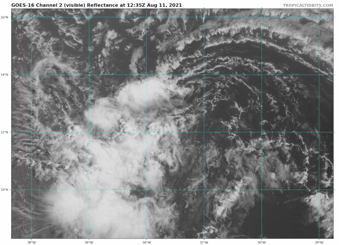
It’s quite apparent on visible imagery that 95L has a very elongated circulation, but it seems to be rotating to a more vertical orientation. Also, since one end is covered in convection and the other end is exposed, the dry end might weaken and die off, or the new orientation could help the circulation tighten.
1 likes
Irene '11 Sandy '12 Hermine '16 5/15/2018 Derecho Fay '20 Isaias '20 Elsa '21 Henri '21 Ida '21
I am only a meteorology enthusiast who knows a decent amount about tropical cyclones. Look to the professional mets, the NHC, or your local weather office for the best information.
I am only a meteorology enthusiast who knows a decent amount about tropical cyclones. Look to the professional mets, the NHC, or your local weather office for the best information.
-
USVIKimmie

- Tropical Depression

- Posts: 51
- Joined: Fri Sep 07, 2018 10:12 pm
Re: ATL: INVEST 95L - Discussion
Category5Kaiju wrote:I really am not comfortable with how so many members take it right into the islands that were devastated by Irma and Maria 4 years ago (yes, that includes PR). Not saying we will see anything that strong with this storm of course, but it just gives me very discouraging vibes.
Once you've been following a while (not sure how long you've been reading) you'll learn who's bullish and who's words to take as gospel.
0 likes
-
Category5Kaiju
- Category 5
- Posts: 4334
- Joined: Thu Dec 24, 2020 12:45 pm
- Location: Seattle and Phoenix
Re: ATL: INVEST 95L - Discussion
toad strangler wrote:Category5Kaiju wrote:I really am not comfortable with how so many members take it right into the islands that were devastated by Irma and Maria 4 years ago (yes, that includes PR). Not saying we will see anything that strong with this storm of course, but it just gives me very discouraging vibes.
Gotta learn to separate that stuff from the science! There is nothing anyone of us can do to change the outcome of a storm except to prepare.
Yeah I know. All I am saying is that the paths I suppose remind me of those specific events in the past. It's also very hard to imagine that every year since 2015 has featured at least one very damaging and impactful cyclone, so it almost feels like with every new season we know we're going to see some very bad storm but we don't know where in the Atlantic it will impact exactly.
0 likes
Unless explicitly stated, all info in my posts is based on my own opinions and observations. Tropical storms and hurricanes can be extremely dangerous. Refer to an accredited weather research agency or meteorologist if you need to make serious decisions regarding an approaching storm.
-
Stormybajan

- Category 1

- Posts: 453
- Joined: Thu May 20, 2021 3:21 pm
- Location: Windward Islands
Re: ATL: INVEST 95L - Discussion
Convection looks to be on the slight increase again right now as it heads west. I think whats a bit encouraging atleast right now is that models are aggressive with this as of yet. Maybe it will stay weak and traverse through the leewards as a strong wave
0 likes
Sad West Indies and Manchester United fan ⚽️

Re: ATL: INVEST 95L - Discussion
Stormybajan wrote:Convection looks to be on the slight increase again right now as it heads west. I think whats a bit encouraging atleast right now is that models are aggressive with this as of yet. Maybe it will stay weak and traverse through the leewards as a strong wave
If you’re wanting a storm to recurve then it would be better for it to strengthen where it’s at now vs further west.
1 likes
-
SFLcane
- S2K Supporter
- Posts: 10281
- Age: 48
- Joined: Sat Jun 05, 2010 1:44 pm
- Location: Lake Worth Florida
Re: ATL: INVEST 95L - Discussion
Cpv17 wrote:Stormybajan wrote:Convection looks to be on the slight increase again right now as it heads west. I think whats a bit encouraging atleast right now is that models are aggressive with this as of yet. Maybe it will stay weak and traverse through the leewards as a strong wave
If you’re wanting a storm to recurve then it would be better for it to strengthen where it’s at now vs further west.
It’s not recurving anytime soon high pressure in place across central Atl will drive everything west.
0 likes
-
tolakram
- Admin

- Posts: 20186
- Age: 62
- Joined: Sun Aug 27, 2006 8:23 pm
- Location: Florence, KY (name is Mark)
Re: ATL: INVEST 95L - Discussion
saved loop

0 likes
M a r k
- - - - -
Join us in chat: Storm2K Chatroom Invite. Android and IOS apps also available.
The posts in this forum are NOT official forecasts and should not be used as such. Posts are NOT endorsed by any professional institution or STORM2K.org. For official information and forecasts, please refer to NHC and NWS products.
-
toad strangler
- S2K Supporter
- Posts: 4546
- Joined: Sun Jul 28, 2013 3:09 pm
- Location: Earth
- Contact:
Re: ATL: INVEST 95L - Discussion
SFLcane wrote:Category5Kaiju wrote:I really am not comfortable with how so many members take it right into the islands that were devastated by Irma and Maria 4 years ago (yes, that includes PR). Not saying we will see anything that strong with this storm of course, but it just gives me very discouraging vibes.
I have vibes of Frances or Irma track with this one.
What's worrisome for me is that by the time 95L gets to the western basin the dates will be full of historical strong storm anniversaries.
6 likes
My Weather Station
https://www.wunderground.com/dashboard/pws/KFLPORTS603
https://www.wunderground.com/dashboard/pws/KFLPORTS603
Re: ATL: INVEST 95L - Discussion
We have 4, maybe 5 days maximum, before 95L reaches the Lesser Antilles. I think it’ll probably develop sometime before then, but probably not for another two days because of its currently elongated circulation. Way too early to guess intensity when it hits the islands until we have a better defined center or a bona-dude TC. Hopefully the HWRF starts running soon, and hopefully it’ll have better success with 95L than Elsa or Fred.
3 likes
Irene '11 Sandy '12 Hermine '16 5/15/2018 Derecho Fay '20 Isaias '20 Elsa '21 Henri '21 Ida '21
I am only a meteorology enthusiast who knows a decent amount about tropical cyclones. Look to the professional mets, the NHC, or your local weather office for the best information.
I am only a meteorology enthusiast who knows a decent amount about tropical cyclones. Look to the professional mets, the NHC, or your local weather office for the best information.
-
Hurrilurker

- Category 2

- Posts: 738
- Joined: Mon Jun 09, 2003 3:32 pm
- Location: San Francisco, CA
Re: ATL: INVEST 95L - Discussion
Teban54 wrote:Weather Dude wrote:I've got a feeling this is gonna be a long thread. Here we go...
We're already at 42 pages for Fred which just formed 3 hours ago. If 95L takes on a similar path as Fred (kind of likely at this point), we might jolly well surpass that by the time it comes close to PR.
It looks like it's tracking right in Fred's wake. Fred looks like it may barely hit hurricane status, if even that, however it looks poised to drop a lot of rain over at least 4-5 states. If 95 comes in a few days behind it with even more rain, mass flooding seems like a very large concern. There won't be time for everything from Fred to dry/drain before they get hit with more.
0 likes

Re: ATL: INVEST 95L - Discussion
Why does Fred and this system have late-season Octoberish vibes?
0 likes
Personal Forecast Disclaimer:
The posts in this forum are NOT official forecast and should not be used as such. They are just the opinion of the poster and may or may not be backed by sound meteorological data. They are NOT endorsed by any professional institution or storm2k.org. For official information, please refer to the NHC and NWS products.
The posts in this forum are NOT official forecast and should not be used as such. They are just the opinion of the poster and may or may not be backed by sound meteorological data. They are NOT endorsed by any professional institution or storm2k.org. For official information, please refer to the NHC and NWS products.
-
Category5Kaiju
- Category 5
- Posts: 4334
- Joined: Thu Dec 24, 2020 12:45 pm
- Location: Seattle and Phoenix
Re: ATL: INVEST 95L - Discussion
Also, if Fred struggles, wouldn't that mean this next system would have to deal with less upwelling from Fred or any associated shear from Fred? If anything I would think we would need to root for Fred to become somewhat strong so this next system would have less favorable conditions to work with down the line? I could be very wrong, but from my understanding this setup looks to be somewhat similar to the Laura/Marco situation?
0 likes
Unless explicitly stated, all info in my posts is based on my own opinions and observations. Tropical storms and hurricanes can be extremely dangerous. Refer to an accredited weather research agency or meteorologist if you need to make serious decisions regarding an approaching storm.
Re: ATL: INVEST 95L - Discussion
SoupBone wrote:Why does Fred and this system have late-season Octoberish vibes?
Because they could both hit Florida.
0 likes
-
Stormybajan
- Category 1
- Posts: 453
- Joined: Thu May 20, 2021 3:21 pm
- Location: Windward Islands
Re: ATL: INVEST 95L - Discussion
Cpv17 wrote:Stormybajan wrote:Convection looks to be on the slight increase again right now as it heads west. I think whats a bit encouraging atleast right now is that models are aggressive with this as of yet. Maybe it will stay weak and traverse through the leewards as a strong wave
If you’re wanting a storm to recurve then it would be better for it to strengthen where it’s at now vs further west.
Yeah I agree with Sflcane here...if it were to strength I dont think it would be allowed to recurve far enough north to miss any land masses but with no well defined circulation for the next few days anything can still happen. Time to sit back and watch
0 likes
Sad West Indies and Manchester United fan ⚽️
-
gatorcane

- S2K Supporter
- Posts: 23708
- Age: 48
- Joined: Sun Mar 13, 2005 3:54 pm
- Location: Boca Raton, FL
Re: ATL: INVEST 95L - Discussion
Could be another one which the big islands interfere with, time will tell. Plenty of time to watch it. Clearly not very organized at all at the moment.
1 likes
Who is online
Users browsing this forum: No registered users and 42 guests