ATL: HENRI - Remnants - Discussion

Moderator: S2k Moderators

Message
Author
User avatar
abajan
S2K Supporter
S2K Supporter
Posts: 4175
Joined: Sun Sep 07, 2003 5:10 am
Location: Barbados

Re: ATL: INVEST 96L - Discussion

#41 Postby abajan » Sun Aug 15, 2021 7:29 pm

Stormybajan wrote:
AlphaToOmega wrote:
000
ABNT20 KNHC 152350
TWOAT

Tropical Weather Outlook
NWS National Hurricane Center Miami FL
800 PM EDT Sun Aug 15 2021

For the North Atlantic...Caribbean Sea and the Gulf of Mexico:

The National Hurricane Center is issuing advisories on Tropical
Storm Fred, located over the east-central Gulf of Mexico, and on
Tropical Depression Grace, located about 100 miles south-southeast
of the Dominican Republic.

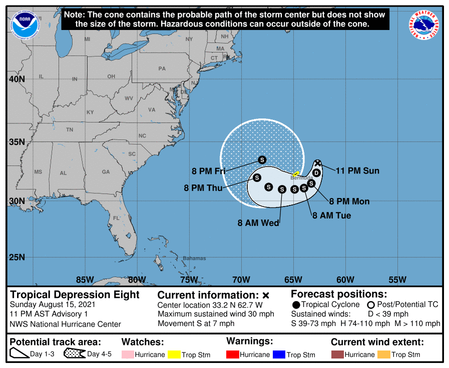
Satellite imagery and radar data from Bermuda indicate that showers
and thunderstorms associated with a small but well-defined area of
low pressure located northeast of Bermuda have continued to become
better organized during the past few hours. If this trend continues,
advisories will likely be initiated on a new tropical depression
later tonight. The system is forecast to move slowly toward the
south or southwest during the next day or so, and then turn westward
on Tuesday, passing near or just east and south of Bermuda.
Interests in Bermuda should monitor the progress of this system,
and a Tropical Storm Watch could be required for that island
tonight.
* Formation chance through 48 hours...high...90 percent.
* Formation chance through 5 days...high...90 percent.

$$
Forecaster Zelinsky

Wow. 90/90 already looks like maybe TD8 tomorrow morning at 2 am?

I'd even say Henri by 5 am looks very likely.
1 likes   

User avatar
abajan
S2K Supporter
S2K Supporter
Posts: 4175
Joined: Sun Sep 07, 2003 5:10 am
Location: Barbados

Re: ATL: INVEST 96L - Discussion

#42 Postby abajan » Sun Aug 15, 2021 8:12 pm

0 likes   

User avatar
TheDreamTraveler
Category 2
Category 2
Posts: 633
Joined: Sun Aug 22, 2010 3:10 am
Location: PA

Re: ATL: INVEST 96L - Discussion

#43 Postby TheDreamTraveler » Sun Aug 15, 2021 9:40 pm

It's possible this could get close to the coast if it gets stronger faster

 https://twitter.com/webberweather/status/1427091523938635778


0 likes   

User avatar
Hammy
Category 5
Category 5
Posts: 5596
Age: 40
Joined: Fri May 25, 2012 5:25 pm
Contact:

Re: ATL: INVEST 96L - Discussion

#44 Postby Hammy » Sun Aug 15, 2021 9:50 pm

No upgrade at 11?
0 likes   
The above post is not official and should not be used as such. It is the opinion of the poster and may or may not be backed by sound meteorological data. It is not endorsed by any professional institution or storm2k.org. For official information, please refer to the NHC and NWS products.

BobHarlem
Category 5
Category 5
Posts: 1671
Joined: Thu Oct 20, 2005 6:11 pm

Re: ATL: INVEST 96L - Discussion

#45 Postby BobHarlem » Sun Aug 15, 2021 9:51 pm

From the Bermuda Weather Service http://www.weather.bm/

"A nearby low has developed into a Tropical Depression and as it continues to meander nearby, slowly circling the Marine area from our east through south it may intensify. Thus, a tropical storm watch has been issued. Expect occasional inclement weather with heavy downpours possible in fringe rain bands should they move across the Island."

Nothing on the NHC Side yet.
4 likes   

User avatar
Owasso
Category 1
Category 1
Posts: 292
Joined: Sat Aug 22, 2020 11:14 pm
Location: Chicago, Illinois

Re: ATL: EIGHT - Tropical Depression - Discussion

#46 Postby Owasso » Sun Aug 15, 2021 10:01 pm

BULLETIN
Tropical Depression Eight Advisory Number 1
NWS National Hurricane Center Miami FL AL082021
1100 PM AST Sun Aug 15 2021

...NEW TROPICAL DEPRESSION FORMS NORTHEAST OF BERMUDA...
...TROPICAL STORM WATCH ISSUED FOR BERMUDA AND NEARBY WATERS...


SUMMARY OF 1100 PM AST...0300 UTC...INFORMATION
-----------------------------------------------
LOCATION...33.2N 62.7W
ABOUT 135 MI...220 KM ENE OF BERMUDA
MAXIMUM SUSTAINED WINDS...30 MPH...45 KM/H
PRESENT MOVEMENT...S OR 175 DEGREES AT 7 MPH...11 KM/H
MINIMUM CENTRAL PRESSURE...1014 MB...29.95 INCHES
1 likes   

wx98
Category 5
Category 5
Posts: 1218
Joined: Sat Aug 25, 2018 9:24 pm

Re: ATL: EIGHT - Tropical Depression - Discussion

#47 Postby wx98 » Sun Aug 15, 2021 10:02 pm

They were dragging with that advisory but understandable since this is now the fourth system they’re warning on.
0 likes   

User avatar
Owasso
Category 1
Category 1
Posts: 292
Joined: Sat Aug 22, 2020 11:14 pm
Location: Chicago, Illinois

Re: ATL: EIGHT - Tropical Depression - Discussion

#48 Postby Owasso » Sun Aug 15, 2021 10:03 pm

Image
0 likes   

User avatar
Hammy
Category 5
Category 5
Posts: 5596
Age: 40
Joined: Fri May 25, 2012 5:25 pm
Contact:

Re: ATL: EIGHT - Tropical Depression - Discussion

#49 Postby Hammy » Sun Aug 15, 2021 10:04 pm

55kt peak seems bold given the models don't do a whole lot before getting absorbed in a few days.
0 likes   
The above post is not official and should not be used as such. It is the opinion of the poster and may or may not be backed by sound meteorological data. It is not endorsed by any professional institution or storm2k.org. For official information, please refer to the NHC and NWS products.

User avatar
Teban54
Category 5
Category 5
Posts: 1985
Joined: Sat May 19, 2018 1:19 pm

Re: ATL: EIGHT - Tropical Depression - Discussion

#50 Postby Teban54 » Sun Aug 15, 2021 10:07 pm

As people suggested earlier, the NHC's official tropical storm names pronunciation guide has Henri's pronunciation as ahn-REE, not HEN-ree.
5 likes   

User avatar
ElectricStorm
Category 5
Category 5
Posts: 4628
Age: 23
Joined: Tue Aug 13, 2019 11:23 pm
Location: Skiatook, OK / Norman, OK

Re: ATL: EIGHT - Tropical Depression - Discussion

#51 Postby ElectricStorm » Sun Aug 15, 2021 10:12 pm

This one might have some potential to become a hurricane. Hopefully no impacts are in store for Bermuda.
0 likes   
I am in no way a professional. Take what I say with a grain of salt as I could be totally wrong. Please refer to the NHC, NWS, or SPC for official information.

Boomer Sooner!

User avatar
Hypercane_Kyle
Category 5
Category 5
Posts: 2912
Joined: Sat Mar 07, 2015 7:58 pm
Location: Cape Canaveral, FL

Re: ATL: EIGHT - Tropical Depression - Discussion

#52 Postby Hypercane_Kyle » Sun Aug 15, 2021 10:15 pm

Hammy wrote:55kt peak seems bold given the models don't do a whole lot before getting absorbed in a few days.


I disagree. I think this one has a bright future ahead of it. Models have struggled often with underestimating storms in the subtropics. Ceiling is higher than the sad batch of storms in the Caribbean/GOMEX right now.
4 likes   
My posts are my own personal opinion, defer to the National Hurricane Center (NHC) and other NOAA products for decision making during hurricane season.

User avatar
Stormybajan
Category 1
Category 1
Posts: 428
Joined: Thu May 20, 2021 3:21 pm
Location: Windward Islands

Re: ATL: EIGHT - Tropical Depression - Discussion

#53 Postby Stormybajan » Sun Aug 15, 2021 10:19 pm

Teban54 wrote:As people suggested earlier, the NHC's official tropical storm names pronunciation guide has Henri's pronunciation as ahn-REE, not HEN-ree.

Off topic: Ahh this sounds like the french pronunciation like french footballer Thierry Henry :wink: . In anycase TD8 really came out of nowhere for me, wasnt expecting it so whatever it does from here on out is an overachievement
3 likes   
Sad West Indies and Manchester United fan ⚽️

User avatar
Kazmit
Category 5
Category 5
Posts: 1916
Age: 21
Joined: Mon Jul 25, 2016 8:49 am
Location: Williamsburg VA for college, Bermuda otherwise

Re: ATL: EIGHT - Tropical Depression - Discussion

#54 Postby Kazmit » Sun Aug 15, 2021 10:29 pm

Clearly visible on the Bermuda radar. We're getting hit by a rain band right now.

http://www.weather.bm/tools/graphics.asp?name=250KM%20SRI&user=
0 likes   
Igor 2010, Sandy 2012, Fay 2014, Gonzalo 2014, Joaquin 2015, Nicole 2016, Humberto 2019

I am only a tropical weather enthusiast. My predictions are not official and may or may not be backed by sound meteorological data. For official information, please refer to the NHC and NWS products.

Sciencerocks
Category 5
Category 5
Posts: 7353
Age: 38
Joined: Thu Jul 06, 2017 1:51 am

Re: ATL: EIGHT - Tropical Depression - Discussion

#55 Postby Sciencerocks » Sun Aug 15, 2021 10:54 pm

Image
1 likes   

User avatar
ElectricStorm
Category 5
Category 5
Posts: 4628
Age: 23
Joined: Tue Aug 13, 2019 11:23 pm
Location: Skiatook, OK / Norman, OK

Re: ATL: EIGHT - Tropical Depression - Discussion

#56 Postby ElectricStorm » Mon Aug 16, 2021 12:57 am

BULLETIN
Tropical Depression Eight Intermediate Advisory Number 1A
NWS National Hurricane Center Miami FL AL082021
200 AM AST Mon Aug 16 2021

...TROPICAL DEPRESSION STRENGTHENS TO THE EAST OF BERMUDA...


SUMMARY OF 200 AM AST...0600 UTC...INFORMATION
----------------------------------------------
LOCATION...32.6N 62.8W
ABOUT 135 MI...220 KM ENE OF BERMUDA
MAXIMUM SUSTAINED WINDS...35 MPH...55 KM/H
PRESENT MOVEMENT...S OR 185 DEGREES AT 8 MPH...13 KM/H
MINIMUM CENTRAL PRESSURE...1012 MB...29.88 INCHES
0 likes   
I am in no way a professional. Take what I say with a grain of salt as I could be totally wrong. Please refer to the NHC, NWS, or SPC for official information.

Boomer Sooner!

AlphaToOmega
Category 5
Category 5
Posts: 1448
Joined: Sat Jun 26, 2021 10:51 am
Location: Somewhere in Massachusetts

Re: ATL: EIGHT - Tropical Depression - Discussion

#57 Postby AlphaToOmega » Mon Aug 16, 2021 5:21 am

In before we get a repeat of this
1 likes   

OuterBanker
S2K Supporter
S2K Supporter
Posts: 1706
Joined: Wed Feb 26, 2003 10:53 am
Location: Nags Head, NC
Contact:

Re: ATL: EIGHT - Tropical Depression - Discussion

#58 Postby OuterBanker » Mon Aug 16, 2021 6:11 am

Future Henri could be great for surfers on the east coast.

Unfortunately there is no room at the inn on the OBX.
But surfers won't care.
Could be perfect sunny weather here with great surf and no threat to anyone.
1 likes   

User avatar
aspen
Category 5
Category 5
Posts: 8061
Joined: Sat Oct 12, 2019 7:10 pm
Location: Connecticut, USA

Re: ATL: EIGHT - Tropical Depression - Discussion

#59 Postby aspen » Mon Aug 16, 2021 6:17 am

From the NHC’s 5am discussion:

The HWRF model turns the cyclone into a major hurricane by 72 hours, but this scenario is considered an extreme outlier given the amount of shear forecast to affect the system on days 3-5. So far this season, the HWRF model has been very shear resistant and has had a high intensity bias. The official intensity forecast closely follows a blend of the IVCN and HCCA consensus models though 60 hours, and then is below those models due to the high-bias contribution of the HWRF model.


TL;DR, the HWRF has cried wolf too many times this season so the NHC is not giving it any recognition in their intensity forecasts. However, we’ll need to watch out if Henri starts to follow the structural forecast of the HWRF, because then it could be on to something; the currently loading 06z run has the center just about fully obscured by convection by late morning/midday tomorrow.
2 likes   
Irene '11 Sandy '12 Hermine '16 5/15/2018 Derecho Fay '20 Isaias '20 Elsa '21 Henri '21 Ida '21

I am only a meteorology enthusiast who knows a decent amount about tropical cyclones. Look to the professional mets, the NHC, or your local weather office for the best information.

User avatar
Yellow Evan
Professional-Met
Professional-Met
Posts: 15960
Age: 25
Joined: Fri Jul 15, 2011 12:48 pm
Location: Henderson, Nevada/Honolulu, HI
Contact:

Re: ATL: EIGHT - Tropical Depression - Discussion

#60 Postby Yellow Evan » Mon Aug 16, 2021 7:03 am

TXNT23 KNES 161143
TCSNTL

A. 08L (NONAME)

B. 16/1131Z

C. 31.8N

D. 62.9W

E. THREE/GOES-E

F. T2.0/2.5

G. IR/EIR/VIS

H. REMARKS...SYSTEM HAS CIRCULARLY DEFINED CLOUD LINES AROUND AN LLCC
THAT IS NEAR THE SMALL ACTIVE COLD OVERCAST RESULTING IN A SHEAR PATTERN
DT OF 2.0. THE 24 HR DEVELOPING TREND RESULTS IN DEVELOPING. MET IS 2.5
AND PT IS 2.0. FT IS BASED ON DT.

I. ADDL POSITIONS

NIL


...PATEL
0 likes   


Return to “2021”

Who is online

Users browsing this forum: No registered users and 5 guests