ATL: PETER - Models

Moderator: S2k Moderators

Message
Author
LarryWx
Category 5
Category 5
Posts: 5795
Joined: Sun Sep 07, 2003 2:04 pm
Location: GA

Re: ATL: INVEST 95L - Models

#41 Postby LarryWx » Mon Sep 13, 2021 3:16 pm

The 12Z EPS heavily favors "da bears"/is more bearish vs the 0Z for the CONUS fwiw with no more than a couple of CONUS hits out of ~51 members. But that's still a long ways out and thus this is still up in the air even though the bears are favored as of now:

12Z EPS at 288 hours:
Image
0 likes   
Personal Forecast Disclaimer:
The posts in this forum are NOT official forecasts and should not be used as such. They are just the opinion of the poster and may or may not be backed by sound meteorological data. They are NOT endorsed by any professional institution or storm2k.org. For official information, please refer to the NHC and NWS products.

AutoPenalti
Category 5
Category 5
Posts: 3950
Age: 27
Joined: Mon Aug 17, 2015 4:16 pm
Location: Ft. Lauderdale, Florida

Re: ATL: INVEST 95L - Models

#42 Postby AutoPenalti » Mon Sep 13, 2021 3:29 pm

LarryWx wrote:The 12Z EPS heavily favors "da bears"/is more bearish vs the 0Z for the CONUS fwiw with no more than a couple of CONUS hits out of ~51 members. But that's still a long ways out and thus this is still up in the air even though the bears are favored as of now:

12Z EPS at 288 hours:
https://i.imgur.com/STFvghI.png

It definitely bears watching.
10 likes   
The posts in this forum are NOT official forecasts and should not be used as such. They are just the opinion of the poster and may or may not be backed by sound meteorological data. They are NOT endorsed by any professional institution or STORM2K. For official information, please refer to products from the NHC and NWS.


Model Runs Cheat Sheet:
GFS (5:30 AM/PM, 11:30 AM/PM)
HWRF, GFDL, UKMET, NAVGEM (6:30-8:00 AM/PM, 12:30-2:00 AM/PM)
ECMWF (1:45 AM/PM)

TCVN
is a weighted averaged

User avatar
cycloneye
Admin
Admin
Posts: 139604
Age: 67
Joined: Thu Oct 10, 2002 10:54 am
Location: San Juan, Puerto Rico

Re: ATL: INVEST 95L - Models

#43 Postby cycloneye » Mon Sep 13, 2021 3:47 pm

0 likes   
Visit the Caribbean-Central America Weather Thread where you can find at first post web cams,radars
and observations from Caribbean basin members Click Here

User avatar
aspen
Category 5
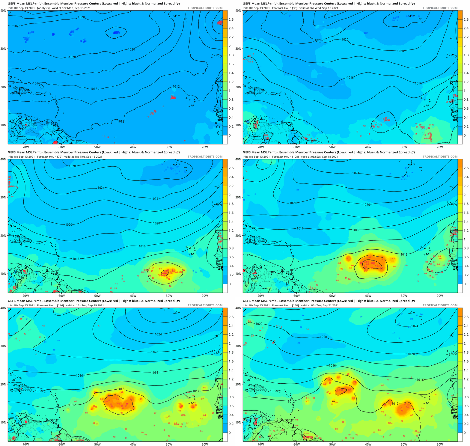
Category 5
Posts: 8061
Joined: Sat Oct 12, 2019 7:10 pm
Location: Connecticut, USA

Re: ATL: INVEST 95L - Models

#44 Postby aspen » Mon Sep 13, 2021 5:03 pm

18z ICON is stronger at 120hr than the prior two runs (988mb).

18z GFS continues to show 95L concentrating further south than the Euro.
0 likes   
Irene '11 Sandy '12 Hermine '16 5/15/2018 Derecho Fay '20 Isaias '20 Elsa '21 Henri '21 Ida '21

I am only a meteorology enthusiast who knows a decent amount about tropical cyclones. Look to the professional mets, the NHC, or your local weather office for the best information.

User avatar
Blown Away
S2K Supporter
S2K Supporter
Posts: 9874
Joined: Wed May 26, 2004 6:17 am

Re: ATL: INVEST 95L - Models

#45 Postby Blown Away » Mon Sep 13, 2021 5:39 pm

aspen wrote:18z ICON is stronger at 120hr than the prior two runs (988mb).

18z GFS continues to show 95L concentrating further south than the Euro.


Image
18z GFS... Strong Cat 1/2 hurricane near 20/60 in @8-9 days... 18z slower and stronger

Fortunately this blocking ridge is NOWHERE to be found...
Last edited by Blown Away on Mon Sep 13, 2021 5:41 pm, edited 1 time in total.
1 likes   
Hurricane Eye Experience: David 79, Irene 99, Frances 04, Jeanne 04, Wilma 05... EYE COMING MY WAY IN 2024…
Hurricane Brush Experience: Andrew 92, Erin 95, Floyd 99, Matthew 16, Irma 17, Ian 22, Nicole 22…

User avatar
kevin
Category 5
Category 5
Posts: 1793
Age: 25
Joined: Wed Aug 28, 2019 4:35 am

Re: ATL: INVEST 95L - Models

#46 Postby kevin » Mon Sep 13, 2021 5:41 pm

95L actually seems to be able to survive the PVS quite well in the 18z GFS despite being a pretty small system. 981 mbar at +228, while the 12z run already weakened it to a TD around the +200 mark.

Image
0 likes   

User avatar
aspen
Category 5
Category 5
Posts: 8061
Joined: Sat Oct 12, 2019 7:10 pm
Location: Connecticut, USA

Re: ATL: INVEST 95L - Models

#47 Postby aspen » Mon Sep 13, 2021 5:44 pm

The huge difference between the 12z run (a strong PVS that shreds Odette into a remnant low) and the 18z run (Hurricane Odette plowing through the PVS) just goes to show how tricky and volatile this forecast is, and how many solutions are still on the table in this early stage.
6 likes   
Irene '11 Sandy '12 Hermine '16 5/15/2018 Derecho Fay '20 Isaias '20 Elsa '21 Henri '21 Ida '21

I am only a meteorology enthusiast who knows a decent amount about tropical cyclones. Look to the professional mets, the NHC, or your local weather office for the best information.

User avatar
ElectricStorm
Category 5
Category 5
Posts: 4623
Age: 23
Joined: Tue Aug 13, 2019 11:23 pm
Location: Skiatook, OK / Norman, OK

Re: ATL: INVEST 95L - Models

#48 Postby ElectricStorm » Mon Sep 13, 2021 5:44 pm

Looks like it'll recurve on this run but yeah the PVS has hardly any effect on it compared to earlier runs.

Still a bunch of possibilities with this system which is why I take model runs this far out with a massive dump truck load of salt
2 likes   
I am in no way a professional. Take what I say with a grain of salt as I could be totally wrong. Please refer to the NHC, NWS, or SPC for official information.

Boomer Sooner!

tolakram
Admin
Admin
Posts: 19182
Age: 60
Joined: Sun Aug 27, 2006 8:23 pm
Location: Florence, KY (name is Mark)

Re: ATL: INVEST 95L - Models

#49 Postby tolakram » Mon Sep 13, 2021 5:44 pm

Just like that the ULL situation is different. HA. Expect this to flip flop and drive us all crazy.
4 likes   
M a r k
- - - - -
Join us in chat: Storm2K Chatroom Invite. Android and IOS apps also available.

The posts in this forum are NOT official forecasts and should not be used as such. Posts are NOT endorsed by any professional institution or STORM2K.org. For official information and forecasts, please refer to NHC and NWS products.

tolakram
Admin
Admin
Posts: 19182
Age: 60
Joined: Sun Aug 27, 2006 8:23 pm
Location: Florence, KY (name is Mark)

Re: ATL: INVEST 95L - Models

#50 Postby tolakram » Mon Sep 13, 2021 5:45 pm

Clear escape route on this run.

Image
0 likes   
M a r k
- - - - -
Join us in chat: Storm2K Chatroom Invite. Android and IOS apps also available.

The posts in this forum are NOT official forecasts and should not be used as such. Posts are NOT endorsed by any professional institution or STORM2K.org. For official information and forecasts, please refer to NHC and NWS products.

User avatar
ElectricStorm
Category 5
Category 5
Posts: 4623
Age: 23
Joined: Tue Aug 13, 2019 11:23 pm
Location: Skiatook, OK / Norman, OK

Re: ATL: INVEST 95L - Models

#51 Postby ElectricStorm » Mon Sep 13, 2021 5:48 pm

Might slam into Bermuda on this run
0 likes   
I am in no way a professional. Take what I say with a grain of salt as I could be totally wrong. Please refer to the NHC, NWS, or SPC for official information.

Boomer Sooner!

tolakram
Admin
Admin
Posts: 19182
Age: 60
Joined: Sun Aug 27, 2006 8:23 pm
Location: Florence, KY (name is Mark)

Re: ATL: INVEST 95L - Models

#52 Postby tolakram » Mon Sep 13, 2021 5:54 pm

Image
0 likes   
M a r k
- - - - -
Join us in chat: Storm2K Chatroom Invite. Android and IOS apps also available.

The posts in this forum are NOT official forecasts and should not be used as such. Posts are NOT endorsed by any professional institution or STORM2K.org. For official information and forecasts, please refer to NHC and NWS products.

User avatar
aspen
Category 5
Category 5
Posts: 8061
Joined: Sat Oct 12, 2019 7:10 pm
Location: Connecticut, USA

Re: ATL: INVEST 95L - Models

#53 Postby aspen » Mon Sep 13, 2021 5:56 pm

Weather Dude wrote:Might slam into Bermuda on this run

Yep, they get hit with a Cat 3.
1 likes   
Irene '11 Sandy '12 Hermine '16 5/15/2018 Derecho Fay '20 Isaias '20 Elsa '21 Henri '21 Ida '21

I am only a meteorology enthusiast who knows a decent amount about tropical cyclones. Look to the professional mets, the NHC, or your local weather office for the best information.

User avatar
kevin
Category 5
Category 5
Posts: 1793
Age: 25
Joined: Wed Aug 28, 2019 4:35 am

Re: ATL: INVEST 95L - Models

#54 Postby kevin » Mon Sep 13, 2021 5:57 pm

While the precise landfall accuracy of a single run of an invest at +276 hours is almost 0%, theoretically this run would be very bad for Bermuda. 95L clearly recurves from the US and Caribbean in this run, but almost directly passes over Bermuda. It also becomes very strong: peaks as a 960 mbar MH. Guess it shows just how uncertain 95L's future is right now as the 12z run dissipated it before it even reached the Caribbean and didn't get lower than 991 mbar.

Image
0 likes   

User avatar
gatorcane
S2K Supporter
S2K Supporter
Posts: 23499
Age: 46
Joined: Sun Mar 13, 2005 3:54 pm
Location: Boca Raton, FL

Re: ATL: INVEST 95L - Models

#55 Postby gatorcane » Mon Sep 13, 2021 6:14 pm

:fishing:

18Z GFS ensembles:

Image
Last edited by gatorcane on Mon Sep 13, 2021 6:15 pm, edited 1 time in total.
0 likes   

User avatar
SFLcane
S2K Supporter
S2K Supporter
Posts: 9627
Age: 46
Joined: Sat Jun 05, 2010 1:44 pm
Location: Lake Worth Florida

Re: ATL: INVEST 95L - Models

#56 Postby SFLcane » Mon Sep 13, 2021 6:15 pm

Lol What… we’re did the tutt go?

Looks like It's either fish or dissipation for this one I think.
0 likes   

User avatar
Teban54
Category 5
Category 5
Posts: 1984
Joined: Sat May 19, 2018 1:19 pm

Re: ATL: INVEST 95L - Models

#57 Postby Teban54 » Mon Sep 13, 2021 6:34 pm

aspen wrote:The huge difference between the 12z run (a strong PVS that shreds Odette into a remnant low) and the 18z run (Hurricane Odette plowing through the PVS) just goes to show how tricky and volatile this forecast is, and how many solutions are still on the table in this early stage.

This is why people should never jump onboard with just one model run.
0 likes   

User avatar
aspen
Category 5
Category 5
Posts: 8061
Joined: Sat Oct 12, 2019 7:10 pm
Location: Connecticut, USA

Re: ATL: INVEST 95L - Models

#58 Postby aspen » Mon Sep 13, 2021 6:35 pm

SFLcane wrote:Lol What… we’re did the tutt go?

Looks like It's either fish or dissipation for this one I think.

Fish, graveyard, or Bermuda.

Now watch that super-ridge steer this into Florida next run.
0 likes   
Irene '11 Sandy '12 Hermine '16 5/15/2018 Derecho Fay '20 Isaias '20 Elsa '21 Henri '21 Ida '21

I am only a meteorology enthusiast who knows a decent amount about tropical cyclones. Look to the professional mets, the NHC, or your local weather office for the best information.

User avatar
Spacecoast
Category 2
Category 2
Posts: 687
Joined: Thu Aug 31, 2017 2:03 pm

Re: ATL: INVEST 95L - Models

#59 Postby Spacecoast » Mon Sep 13, 2021 6:36 pm

SFLcane wrote:Lol What… we’re did the tutt go?


At least everyone got chance to talk about big TUTTS for a few days.
3 likes   

User avatar
Category5Kaiju
Category 5
Category 5
Posts: 3438
Age: 22
Joined: Thu Dec 24, 2020 12:45 pm
Location: Seattle

Re: ATL: INVEST 95L - Models

#60 Postby Category5Kaiju » Mon Sep 13, 2021 6:45 pm

SFLcane wrote:Lol What… we’re did the tutt go?

Looks like It's either fish or dissipation for this one I think.


Nah, it's either fish mega Cat 4, dissipation over Puerto Rico, or Cat 5 Andrew-like hit :ggreen:

But yeah, seriously, I have no clue. At this point I am going to just wait and see as the models are simply so erratic.
2 likes   
Unless explicitly stated, all information covered in my posts is based on my opinions and observations. Please refer to a professional meteorologist or an accredited weather research agency otherwise, especially if serious decisions must be made in the event of a potentially life-threatening tropical storm or hurricane.


Return to “2021”

Who is online

Users browsing this forum: No registered users and 8 guests