ATL: SAM - Remnants - Discussion
Moderator: S2k Moderators
-
InfernoFlameCat

- Category 5

- Posts: 2127
- Age: 22
- Joined: Mon Dec 14, 2020 10:52 am
- Location: Buford, GA
Re: ATL: SAM - Hurricane - Discussion
Keep in mind that at such a low latitude the atmosphere is in fact warmer and has more air that Sam can take advantage of. What I mean is that the earth's atmosphere bulges more the closer to the equator you get due to centrifugal forces due to the Earth's spin. In other words, Sam might have higher cloud tops than indicated by inferred satellites. Also the action of which Sam is bringing up warm air to high levels means that it is warming the atmosphere above it so cloud tops may have not decreased as much in height as it appears due to these factors. IMHO.
10 likes
I am by no means a professional. DO NOT look at my forecasts for official information or make decisions based on what I post.
Goal: to become a registered expert over tropical and subtropical cyclones.
Goal: to become a registered expert over tropical and subtropical cyclones.
-
grapealcoholic
- Category 2

- Posts: 703
- Joined: Tue Aug 10, 2021 3:26 pm
Re: ATL: SAM - Hurricane - Discussion
InfernoFlameCat wrote:Keep in mind that at such a low latitude the atmosphere is in fact warmer and has more air that Sam can take advantage of. What I mean is that the earth's atmosphere bulges more the closer to the equator you get due to centrifugal forces due to the Earth's spin. In other words, Sam might have higher cloud tops than indicated by inferred satellites. Also the action of which Sam is bringing up warm air to high levels means that it is warming the atmosphere above it so cloud tops may have not decreased as much in height as it appears due to these factors. IMHO.
Eh, the upper troposphere doesn't really vary much in temperature. I think it'll fire deeper convection soon
It's already heating the core extremely efficiently right now with an eye, even if it isn't THAT deep
0 likes
-
grapealcoholic
- Category 2
- Posts: 703
- Joined: Tue Aug 10, 2021 3:26 pm
Re: ATL: SAM - Hurricane - Discussion Update= 00z Best Track up to 85 kt
Storms trade "convection deepness" for structure whenever they can. So a Cat 2 with a round warm eye probably shouldn't have deep convection, otherwise it would be a Cat 4.
0 likes
-
Iceresistance

- Category 5
- Posts: 9592
- Age: 22
- Joined: Sat Oct 10, 2020 9:45 am
- Location: Tecumseh, OK/Norman, OK
Re: ATL: SAM - Hurricane - Discussion Update= 00z Best Track up to 85 kt
grapealcoholic wrote:Storms trade "convection deepness" for structure whenever they can. So a Cat 2 with a round warm eye probably shouldn't have deep convection, otherwise it would be a Cat 4.
Unless Recon proves it otherwise, but Sam is too far out for Recon right now . . .
0 likes
Bill 2015 & Beta 2020
Winter 2020-2021
All observations are in Tecumseh, OK unless otherwise noted.
Winter posts are focused mainly for Oklahoma & Texas.
Take any of my forecasts with a grain of salt, refer to the NWS, SPC, and NHC for official information
Never say Never with weather! Because ANYTHING is possible!
Winter 2020-2021
All observations are in Tecumseh, OK unless otherwise noted.
Winter posts are focused mainly for Oklahoma & Texas.
Take any of my forecasts with a grain of salt, refer to the NWS, SPC, and NHC for official information
Never say Never with weather! Because ANYTHING is possible!
-
skyline385

- Category 5
- Posts: 2728
- Age: 35
- Joined: Wed Aug 26, 2020 11:15 pm
- Location: Houston TX
Re: ATL: SAM - Hurricane - Discussion
InfernoFlameCat wrote:Keep in mind that at such a low latitude the atmosphere is in fact warmer and has more air that Sam can take advantage of. What I mean is that the earth's atmosphere bulges more the closer to the equator you get due to centrifugal forces due to the Earth's spin. In other words, Sam might have higher cloud tops than indicated by inferred satellites. Also the action of which Sam is bringing up warm air to high levels means that it is warming the atmosphere above it so cloud tops may have not decreased as much in height as it appears due to these factors. IMHO.
I doubt it matters much. Remember that Iota and Eta which were both closer to the equator too had extremely cold pink tops but they never even made it to Cat 5 and people called the cloud tops deceiving since it was October saying the atmosphere is colder back then.
0 likes
-
grapealcoholic
- Category 2
- Posts: 703
- Joined: Tue Aug 10, 2021 3:26 pm
Re: ATL: SAM - Hurricane - Discussion
skyline385 wrote:InfernoFlameCat wrote:Keep in mind that at such a low latitude the atmosphere is in fact warmer and has more air that Sam can take advantage of. What I mean is that the earth's atmosphere bulges more the closer to the equator you get due to centrifugal forces due to the Earth's spin. In other words, Sam might have higher cloud tops than indicated by inferred satellites. Also the action of which Sam is bringing up warm air to high levels means that it is warming the atmosphere above it so cloud tops may have not decreased as much in height as it appears due to these factors. IMHO.
I doubt it matters much. Remember that Iota and Eta which were both closer to the equator too had extremely cold pink tops but they never even made it to Cat 5 and people called the cloud tops deceiving since it was October saying the atmosphere is colder back then.
Colder upper air temperatures do support stronger storms. I just think Eta needed time to catch up to it's convection
0 likes
-
Iceresistance
- Category 5
- Posts: 9592
- Age: 22
- Joined: Sat Oct 10, 2020 9:45 am
- Location: Tecumseh, OK/Norman, OK
Re: ATL: SAM - Hurricane - Discussion
Colder Cloud Tops starting to blow at the Eyewall, Sam is also moving WNW . . .
1 likes
Bill 2015 & Beta 2020
Winter 2020-2021
All observations are in Tecumseh, OK unless otherwise noted.
Winter posts are focused mainly for Oklahoma & Texas.
Take any of my forecasts with a grain of salt, refer to the NWS, SPC, and NHC for official information
Never say Never with weather! Because ANYTHING is possible!
Winter 2020-2021
All observations are in Tecumseh, OK unless otherwise noted.
Winter posts are focused mainly for Oklahoma & Texas.
Take any of my forecasts with a grain of salt, refer to the NWS, SPC, and NHC for official information
Never say Never with weather! Because ANYTHING is possible!
-
skyline385
- Category 5
- Posts: 2728
- Age: 35
- Joined: Wed Aug 26, 2020 11:15 pm
- Location: Houston TX
Re: ATL: SAM - Hurricane - Discussion
grapealcoholic wrote:skyline385 wrote:InfernoFlameCat wrote:Keep in mind that at such a low latitude the atmosphere is in fact warmer and has more air that Sam can take advantage of. What I mean is that the earth's atmosphere bulges more the closer to the equator you get due to centrifugal forces due to the Earth's spin. In other words, Sam might have higher cloud tops than indicated by inferred satellites. Also the action of which Sam is bringing up warm air to high levels means that it is warming the atmosphere above it so cloud tops may have not decreased as much in height as it appears due to these factors. IMHO.
I doubt it matters much. Remember that Iota and Eta which were both closer to the equator too had extremely cold pink tops but they never even made it to Cat 5 and people called the cloud tops deceiving since it was October saying the atmosphere is colder back then.
Colder upper air temperatures do support stronger storms. I just think Eta needed time to catch up to it's convection
Yea they would support a stronger system simply because of the difference in temperatures but at the same time, the IR imagery would also show much colder tops than normal since the atmosphere is already cold.
0 likes

Re: ATL: SAM - Hurricane - Discussion
skyline385 wrote:InfernoFlameCat wrote:Keep in mind that at such a low latitude the atmosphere is in fact warmer and has more air that Sam can take advantage of. What I mean is that the earth's atmosphere bulges more the closer to the equator you get due to centrifugal forces due to the Earth's spin. In other words, Sam might have higher cloud tops than indicated by inferred satellites. Also the action of which Sam is bringing up warm air to high levels means that it is warming the atmosphere above it so cloud tops may have not decreased as much in height as it appears due to these factors. IMHO.
I doubt it matters much. Remember that Iota and Eta which were both closer to the equator too had extremely cold pink tops but they never even made it to Cat 5 and people called the cloud tops deceiving since it was October saying the atmosphere is colder back then.
I think that only applied to Eta. Iota actually had more typical cloud tops and ADT was also more in line with actual intensity.
0 likes
TC naming lists: retirements and intensity
Most aggressive Advisory #1's in North Atlantic (cr. kevin for starting the list)
Most aggressive Advisory #1's in North Atlantic (cr. kevin for starting the list)
-
grapealcoholic
- Category 2
- Posts: 703
- Joined: Tue Aug 10, 2021 3:26 pm
Re: ATL: SAM - Hurricane - Discussion
Teban54 wrote:skyline385 wrote:InfernoFlameCat wrote:Keep in mind that at such a low latitude the atmosphere is in fact warmer and has more air that Sam can take advantage of. What I mean is that the earth's atmosphere bulges more the closer to the equator you get due to centrifugal forces due to the Earth's spin. In other words, Sam might have higher cloud tops than indicated by inferred satellites. Also the action of which Sam is bringing up warm air to high levels means that it is warming the atmosphere above it so cloud tops may have not decreased as much in height as it appears due to these factors. IMHO.
I doubt it matters much. Remember that Iota and Eta which were both closer to the equator too had extremely cold pink tops but they never even made it to Cat 5 and people called the cloud tops deceiving since it was October saying the atmosphere is colder back then.
I think that only applied to Eta. Iota actually had more typical cloud tops and ADT was also more in line with actual intensity.
Eta's raw ADT was much higher than it's adjusted. I think it could have gotten below 900 if it maintained those cloud tops
0 likes
-
Sciencerocks
- Category 5
- Posts: 10186
- Age: 40
- Joined: Thu Jul 06, 2017 1:51 am
-
ElectricStorm

- Category 5
- Posts: 5147
- Age: 25
- Joined: Tue Aug 13, 2019 11:23 pm
- Location: Norman, OK
Re: ATL: SAM - Hurricane - Discussion
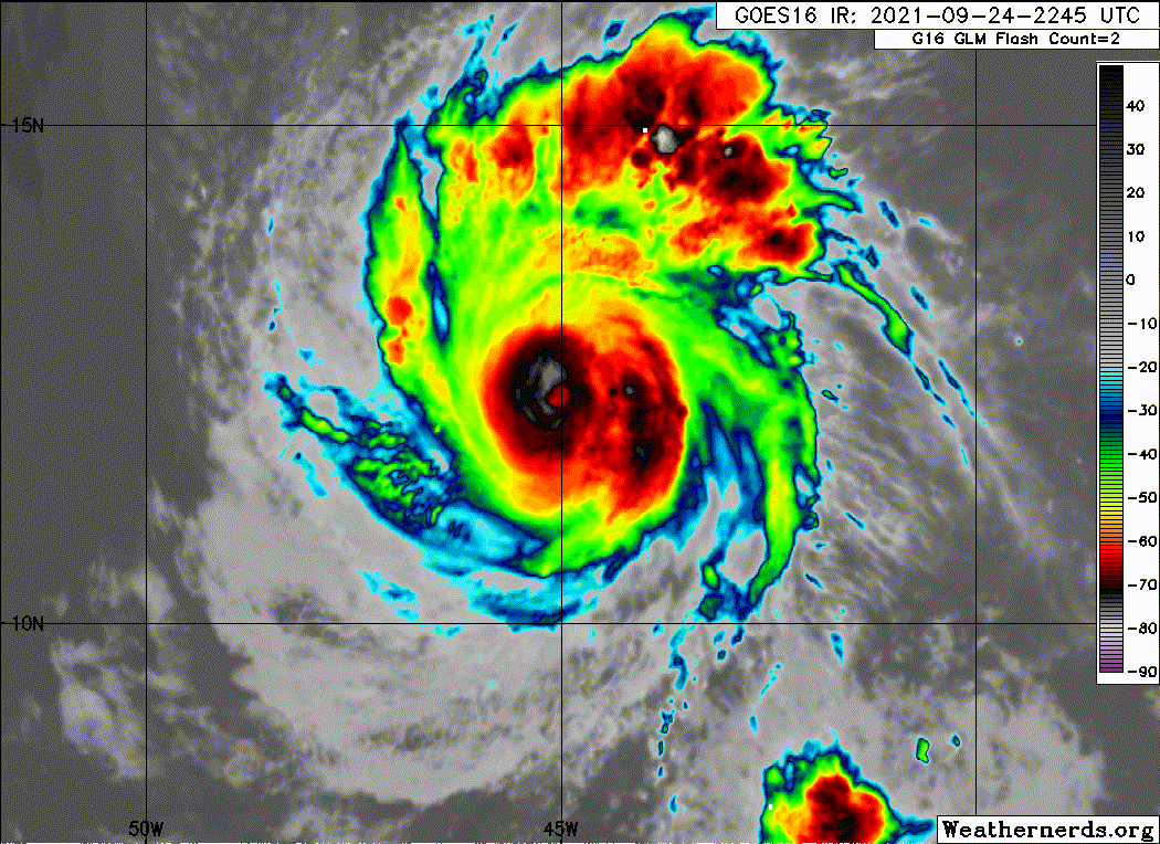
New towers starting to go up around the center
0 likes
B.S Meteorology, University of Oklahoma '25
Please refer to the NHC, NWS, or SPC for official information.
Please refer to the NHC, NWS, or SPC for official information.
-
galaxy401

- Category 5
- Posts: 2446
- Age: 30
- Joined: Sat Aug 25, 2012 9:04 pm
- Location: Casa Grande, Arizona
Re: ATL: SAM - Hurricane - Discussion
Sam is bombing out now. At this rate, it will be a major in just a few hours (if not one already).
0 likes
Got my eyes on moving right into Hurricane Alley: Florida.
-
InfernoFlameCat
- Category 5
- Posts: 2127
- Age: 22
- Joined: Mon Dec 14, 2020 10:52 am
- Location: Buford, GA
Re: ATL: SAM - Hurricane - Discussion
Number 9 alert. Sam looks like number 9! RI continues!
0 likes
I am by no means a professional. DO NOT look at my forecasts for official information or make decisions based on what I post.
Goal: to become a registered expert over tropical and subtropical cyclones.
Goal: to become a registered expert over tropical and subtropical cyclones.
-
ElectricStorm
- Category 5
- Posts: 5147
- Age: 25
- Joined: Tue Aug 13, 2019 11:23 pm
- Location: Norman, OK
Re: ATL: SAM - Hurricane - Discussion
CI# /Pressure/ Vmax
4.3 / 986.4mb/ 72.2kt
Final T# Adj T# Raw T#
4.3 5.3 5.3
Estimated radius of max. wind based on IR : 13 km
Center Temp : +10.3C
Final Ts should start shooting up soon
4.3 / 986.4mb/ 72.2kt
Final T# Adj T# Raw T#
4.3 5.3 5.3
Estimated radius of max. wind based on IR : 13 km
Center Temp : +10.3C
Final Ts should start shooting up soon
2 likes
B.S Meteorology, University of Oklahoma '25
Please refer to the NHC, NWS, or SPC for official information.
Please refer to the NHC, NWS, or SPC for official information.
-
skyline385
- Category 5
- Posts: 2728
- Age: 35
- Joined: Wed Aug 26, 2020 11:15 pm
- Location: Houston TX
Re: ATL: SAM - Hurricane - Discussion
The last band is waning as well, this will probably end up being annular soon. The small size also supports it...
0 likes
-
grapealcoholic
- Category 2
- Posts: 703
- Joined: Tue Aug 10, 2021 3:26 pm
Re: ATL: SAM - Hurricane - Discussion
Given the continuous organization, I can see NHC going higher than the 85kt best track intensity in the upcoming advisory.
2 likes
TC naming lists: retirements and intensity
Most aggressive Advisory #1's in North Atlantic (cr. kevin for starting the list)
Most aggressive Advisory #1's in North Atlantic (cr. kevin for starting the list)
-
ElectricStorm
- Category 5
- Posts: 5147
- Age: 25
- Joined: Tue Aug 13, 2019 11:23 pm
- Location: Norman, OK
Re: ATL: SAM - Hurricane - Discussion
Hurricane Sam Advisory Number 10
NWS National Hurricane Center Miami FL AL182021
1100 PM AST Fri Sep 24 2021
...SAM NOW A CATEGORY 2 HURRICANE...
...FORECAST TO BECOME A MAJOR HURRICANE ON SATURDAY...
SUMMARY OF 1100 PM AST...0300 UTC...INFORMATION
-----------------------------------------------
LOCATION...12.4N 45.9W
ABOUT 1215 MI...1950 KM ESE OF THE NORTHERN LEEWARD ISLANDS
MAXIMUM SUSTAINED WINDS...100 MPH...155 KM/H
PRESENT MOVEMENT...WNW OR 285 DEGREES AT 14 MPH...22 KM/H
MINIMUM CENTRAL PRESSURE...982 MB...29.00 INCHES
2 likes
B.S Meteorology, University of Oklahoma '25
Please refer to the NHC, NWS, or SPC for official information.
Please refer to the NHC, NWS, or SPC for official information.
-
grapealcoholic
- Category 2
- Posts: 703
- Joined: Tue Aug 10, 2021 3:26 pm
Re: ATL: SAM - Hurricane - Discussion
Surprised they didn't go with 100 kts given the eye temp
0 likes
Who is online
Users browsing this forum: No registered users and 28 guests