ATL: GRACE - Remnants - Discussion

Moderator: S2k Moderators

Message
Author
User avatar
captainbarbossa19
Category 5
Category 5
Posts: 1040
Joined: Wed Aug 21, 2019 11:09 pm
Location: Starkville, MS

Re: ATL: INVEST 95L - Discussion

#61 Postby captainbarbossa19 » Wed Aug 11, 2021 10:20 am

Cpv17 wrote:
SoupBone wrote:Why does Fred and this system have late-season Octoberish vibes?


Because they could both hit Florida.


I think the ridge is a lot stronger now than it is normally in October. Most of the time, storms approach from the south or southwest when they hit Florida in October. These systems are all moving mainly east to west. It's so far out, but I would not be surprised to see a stronger ridge later on. I think some models were hinting at stronger ridging the other day after Fred makes landfall in Florida.
1 likes   

User avatar
Cpv17
Category 5
Category 5
Posts: 4441
Joined: Wed Dec 07, 2016 2:24 pm
Location: Wharton/El Campo, TX

Re: ATL: INVEST 95L - Discussion

#62 Postby Cpv17 » Wed Aug 11, 2021 10:27 am

captainbarbossa19 wrote:
Cpv17 wrote:
SoupBone wrote:Why does Fred and this system have late-season Octoberish vibes?


Because they could both hit Florida.


I think the ridge is a lot stronger now than it is normally in October. Most of the time, storms approach from the south or southwest when they hit Florida in October. These systems are all moving mainly east to west. It's so far out, but I would not be surprised to see a stronger ridge later on. I think some models were hinting at stronger ridging the other day after Fred makes landfall in Florida.


Take a look at the 6z GEFS. I believe this storm will stay on the southerly side of the guidance.
1 likes   

User avatar
Cpv17
Category 5
Category 5
Posts: 4441
Joined: Wed Dec 07, 2016 2:24 pm
Location: Wharton/El Campo, TX

Re: ATL: INVEST 95L - Discussion

#63 Postby Cpv17 » Wed Aug 11, 2021 10:29 am

Stormybajan wrote:
Cpv17 wrote:
Stormybajan wrote:Convection looks to be on the slight increase again right now as it heads west. I think whats a bit encouraging atleast right now is that models are aggressive with this as of yet. Maybe it will stay weak and traverse through the leewards as a strong wave


If you’re wanting a storm to recurve then it would be better for it to strengthen where it’s at now vs further west.

Yeah I agree with Sflcane here...if it were to strength I dont think it would be allowed to recurve far enough north to miss any land masses but with no well defined circulation for the next few days anything can still happen. Time to sit back and watch


Yes but in general I’m saying if a storm strengthens further east it has a better chance to recurve unless of course strong ridging is present.
0 likes   

User avatar
abajan
S2K Supporter
S2K Supporter
Posts: 4175
Joined: Sun Sep 07, 2003 5:10 am
Location: Barbados

Re: ATL: INVEST 95L - Discussion

#64 Postby abajan » Wed Aug 11, 2021 11:09 am

USVIKimmie wrote:
Category5Kaiju wrote:I really am not comfortable with how so many members take it right into the islands that were devastated by Irma and Maria 4 years ago (yes, that includes PR). Not saying we will see anything that strong with this storm of course, but it just gives me very discouraging vibes.

Once you've been following a while (not sure how long you've been reading) you'll learn who's bullish and who's words to take as gospel.

Just in case there's any confusion, they were referring to ensemble members (of a weather model), not Storm2K members! :lol:
5 likes   

User avatar
msbee
S2K Supporter
S2K Supporter
Posts: 3010
Joined: Wed Jun 11, 2003 10:11 am
Location: St. Maarten

Re: ATL: INVEST 95L - Discussion

#65 Postby msbee » Wed Aug 11, 2021 12:00 pm

Category5Kaiju wrote:I really am not comfortable with how so many members take it right into the islands that were devastated by Irma and Maria 4 years ago (yes, that includes PR). Not saying we will see anything that strong with this storm of course, but it just gives me very discouraging vibes.

Me too
0 likes   
Too many hurricanes to remember

AlphaToOmega
Category 5
Category 5
Posts: 1448
Joined: Sat Jun 26, 2021 10:51 am
Location: Somewhere in Massachusetts

Re: ATL: INVEST 95L - Discussion

#66 Postby AlphaToOmega » Wed Aug 11, 2021 12:46 pm

A tropical wave located over the eastern tropical Atlantic several
hundred miles west-southwest of the Cabo Verde Islands continues to
produce disorganized showers and thunderstorms. Environmental
conditions are expected to become gradually more conducive for
development of this system, and a tropical depression could form by
early next week while moving generally westward across the tropical
Atlantic near 20 mph. This system could reach portions of the
Leeward Islands by late Saturday.
* Formation chance through 48 hours...low...30 percent.
* Formation chance through 5 days...medium...50 percent.
0 likes   

User avatar
ElectricStorm
Category 5
Category 5
Posts: 4624
Age: 23
Joined: Tue Aug 13, 2019 11:23 pm
Location: Skiatook, OK / Norman, OK

Re: ATL: INVEST 95L - Discussion

#67 Postby ElectricStorm » Wed Aug 11, 2021 1:45 pm

I don't want to get ahead of myself and hype anything up but if this manages to stay north of the islands and not do what Fred is doing, I think there's a chance this may get pretty strong. Of course there's a lot of other factors than just land but I've got an uneasy feeling about this one, although I do think it will go over Al least one of the greater Antilles. Especially the flood threat for the areas hit by Fred.
Last edited by ElectricStorm on Wed Aug 11, 2021 2:03 pm, edited 1 time in total.
0 likes   
I am in no way a professional. Take what I say with a grain of salt as I could be totally wrong. Please refer to the NHC, NWS, or SPC for official information.

Boomer Sooner!

User avatar
captainbarbossa19
Category 5
Category 5
Posts: 1040
Joined: Wed Aug 21, 2019 11:09 pm
Location: Starkville, MS

Re: ATL: INVEST 95L - Discussion

#68 Postby captainbarbossa19 » Wed Aug 11, 2021 1:47 pm

AlphaToOmega wrote:
A tropical wave located over the eastern tropical Atlantic several
hundred miles west-southwest of the Cabo Verde Islands continues to
produce disorganized showers and thunderstorms. Environmental
conditions are expected to become gradually more conducive for
development of this system, and a tropical depression could form by
early next week while moving generally westward across the tropical
Atlantic near 20 mph. This system could reach portions of the
Leeward Islands by late Saturday.
* Formation chance through 48 hours...low...30 percent.
* Formation chance through 5 days...medium...50 percent.


Increasing chances.
1 likes   

User avatar
cycloneye
Admin
Admin
Posts: 139702
Age: 67
Joined: Thu Oct 10, 2002 10:54 am
Location: San Juan, Puerto Rico

Re: ATL: INVEST 95L - Discussion

#69 Postby cycloneye » Wed Aug 11, 2021 1:51 pm

AL, 95, 2021081118, , BEST, 0, 121N, 350W, 25, 1010, DB
1 likes   
Visit the Caribbean-Central America Weather Thread where you can find at first post web cams,radars
and observations from Caribbean basin members Click Here

Sciencerocks
Category 5
Category 5
Posts: 7314
Age: 38
Joined: Thu Jul 06, 2017 1:51 am

Re: ATL: INVEST 95L - Discussion

#70 Postby Sciencerocks » Wed Aug 11, 2021 2:24 pm

Image
1 likes   

User avatar
captainbarbossa19
Category 5
Category 5
Posts: 1040
Joined: Wed Aug 21, 2019 11:09 pm
Location: Starkville, MS

Re: ATL: INVEST 95L - Discussion

#71 Postby captainbarbossa19 » Wed Aug 11, 2021 4:16 pm

This sure looks like it is slowly getting better organized. I think in a few days, it's going to really take off. I just hope it does not get too strong.
2 likes   

User avatar
cycloneye
Admin
Admin
Posts: 139702
Age: 67
Joined: Thu Oct 10, 2002 10:54 am
Location: San Juan, Puerto Rico

Re: ATL: INVEST 95L - Discussion

#72 Postby cycloneye » Wed Aug 11, 2021 5:47 pm

5 likes   
Visit the Caribbean-Central America Weather Thread where you can find at first post web cams,radars
and observations from Caribbean basin members Click Here

AlphaToOmega
Category 5
Category 5
Posts: 1448
Joined: Sat Jun 26, 2021 10:51 am
Location: Somewhere in Massachusetts

Re: ATL: INVEST 95L - Discussion

#73 Postby AlphaToOmega » Wed Aug 11, 2021 6:50 pm

Fred now a tropical depression, Invest 95L now at 60%
A tropical wave located over the central tropical Atlantic about
1600 miles east of the Lesser Antilles continues to produce
disorganized showers and thunderstorms. Environmental conditions
are expected to gradually become more conducive for development,
and a tropical depression could form by early next week while the
system moves generally westward at about 20 mph across the tropical
Atlantic. This system could reach portions of the Leeward Islands
by late Saturday.
* Formation chance through 48 hours...low...30 percent.
* Formation chance through 5 days...medium...60 percent.
5 likes   

User avatar
Nimbus
Category 5
Category 5
Posts: 4935
Joined: Mon Jul 19, 2004 10:54 am

Re: ATL: INVEST 95L - Discussion

#74 Postby Nimbus » Wed Aug 11, 2021 7:46 pm

Its elongated now and moving west fairly fast so development isn't expected till the islands Saturday.
Levi showed two models with high pressure providing a more favorable environment for development then, but the ridge position is still evolving that far out for track south/north/through Hispaniola.
0 likes   

User avatar
gatorcane
S2K Supporter
S2K Supporter
Posts: 23499
Age: 46
Joined: Sun Mar 13, 2005 3:54 pm
Location: Boca Raton, FL

Re: ATL: INVEST 95L - Discussion

#75 Postby gatorcane » Wed Aug 11, 2021 7:49 pm

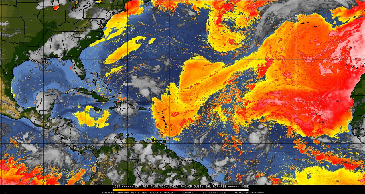
Dry air looks to be an inhibiting factor. According to the GFS, that surge of extremely dry air to the east quickly pushes west and engulfs this system:

Image
0 likes   

User avatar
InfernoFlameCat
Category 5
Category 5
Posts: 1966
Age: 21
Joined: Mon Dec 14, 2020 10:52 am
Location: Buford, GA

Re: ATL: INVEST 95L - Discussion

#76 Postby InfernoFlameCat » Wed Aug 11, 2021 7:53 pm

Doubt it will do more than slow the system.
0 likes   
I am by no means a professional. DO NOT look at my forecasts for official information or make decisions based on what I post.

Goal: to become a registered expert over tropical and subtropical cyclones.

User avatar
Category5Kaiju
Category 5
Category 5
Posts: 3442
Age: 22
Joined: Thu Dec 24, 2020 12:45 pm
Location: Seattle

Re: ATL: INVEST 95L - Discussion

#77 Postby Category5Kaiju » Wed Aug 11, 2021 8:05 pm

Eh, it's riding in front of the SAL plume, if anything this is a better spot to be in compared to right under a plume as the latter would surely increase the risk of the wave going slightly north and then succumbing to the dry air. The position it looks to be currently in with respect to the SAL does not looks like it will be a long term issue imho
1 likes   
Unless explicitly stated, all information covered in my posts is based on my opinions and observations. Please refer to a professional meteorologist or an accredited weather research agency otherwise, especially if serious decisions must be made in the event of a potentially life-threatening tropical storm or hurricane.

User avatar
AtlanticWind
S2K Supporter
S2K Supporter
Posts: 1809
Age: 65
Joined: Sun Aug 08, 2004 9:57 pm
Location: Plantation,Fla

Re: ATL: INVEST 95L - Discussion

#78 Postby AtlanticWind » Wed Aug 11, 2021 8:21 pm

Looking better tonight , this is likely to form I believe.
1 likes   

AxaltaRacing24
Category 5
Category 5
Posts: 1710
Age: 24
Joined: Wed Jul 27, 2016 11:14 am
Location: Jupiter, FL

Re: ATL: INVEST 95L - Discussion

#79 Postby AxaltaRacing24 » Wed Aug 11, 2021 8:24 pm

Despite the model's best efforts, I think this will eventually develop.
0 likes   

User avatar
InfernoFlameCat
Category 5
Category 5
Posts: 1966
Age: 21
Joined: Mon Dec 14, 2020 10:52 am
Location: Buford, GA

Re: ATL: INVEST 95L - Discussion

#80 Postby InfernoFlameCat » Wed Aug 11, 2021 8:24 pm

Shame I am going to miss the peak of this storm if it develops. Got boot camp for ROTC in college next week.
1 likes   
I am by no means a professional. DO NOT look at my forecasts for official information or make decisions based on what I post.

Goal: to become a registered expert over tropical and subtropical cyclones.


Return to “2021”

Who is online

Users browsing this forum: No registered users and 3 guests