ATL: PETER - Models

Moderator: S2k Moderators

Message
Author
User avatar
GeneratorPower
S2K Supporter
S2K Supporter
Posts: 1648
Age: 44
Joined: Sun Dec 18, 2005 11:48 pm
Location: Huntsville, AL

Re: ATL: INVEST 95L - Models

#61 Postby GeneratorPower » Mon Sep 13, 2021 6:46 pm

Spacecoast wrote:
SFLcane wrote:Lol What… we’re did the tutt go?


At least everyone got chance to talk about big TUTTS for a few days.


And just minutes after the best post of 2021, a new record was set. Congratulations.
3 likes   

User avatar
SFLcane
S2K Supporter
S2K Supporter
Posts: 9627
Age: 46
Joined: Sat Jun 05, 2010 1:44 pm
Location: Lake Worth Florida

Re: ATL: INVEST 95L - Models

#62 Postby SFLcane » Mon Sep 13, 2021 6:49 pm

All seriousness if this thing is faster and now has less tutt influence things could get worrisome.Still many days out and lots can change.
1 likes   

User avatar
gatorcane
S2K Supporter
S2K Supporter
Posts: 23499
Age: 46
Joined: Sun Mar 13, 2005 3:54 pm
Location: Boca Raton, FL

Re: ATL: INVEST 95L - Models

#63 Postby gatorcane » Mon Sep 13, 2021 7:17 pm

Looks like nearly an identical 500MB setup for 95l as with Larry on this particular run of the long-range GFS with a one-two punch of troughs rolling off the eastern seaboard. Those troughs usher in well below normal temps for much of the eastern half of the CONUS:

Image
0 likes   

User avatar
Spacecoast
Category 2
Category 2
Posts: 687
Joined: Thu Aug 31, 2017 2:03 pm

Re: ATL: INVEST 95L - Models

#64 Postby Spacecoast » Mon Sep 13, 2021 7:54 pm

Last two GEFS runs: tighter spread, slight shift east w/ most members E of 20N, 60W.
A couple of fizzler's NE of LA..... Only the strong survive?

Image
Image
Last edited by Spacecoast on Mon Sep 13, 2021 8:20 pm, edited 2 times in total.
0 likes   

User avatar
gatorcane
S2K Supporter
S2K Supporter
Posts: 23499
Age: 46
Joined: Sun Mar 13, 2005 3:54 pm
Location: Boca Raton, FL

Re: ATL: INVEST 95L - Models

#65 Postby gatorcane » Mon Sep 13, 2021 8:15 pm

00Z. SHIPS almost to CAT 3:

Image
Image
1 likes   

User avatar
Hurricaneman
Category 5
Category 5
Posts: 7284
Age: 43
Joined: Tue Aug 31, 2004 3:24 pm
Location: central florida

Re: ATL: INVEST 95L - Models

#66 Postby Hurricaneman » Mon Sep 13, 2021 11:16 pm

The 0zGFS shows the system weaker and also a thinner TUTT than the last few runs
0 likes   

AutoPenalti
Category 5
Category 5
Posts: 3950
Age: 27
Joined: Mon Aug 17, 2015 4:16 pm
Location: Ft. Lauderdale, Florida

Re: ATL: INVEST 95L - Models

#67 Postby AutoPenalti » Mon Sep 13, 2021 11:30 pm

Meh, that trough doesn’t sound convincing.
1 likes   
The posts in this forum are NOT official forecasts and should not be used as such. They are just the opinion of the poster and may or may not be backed by sound meteorological data. They are NOT endorsed by any professional institution or STORM2K. For official information, please refer to products from the NHC and NWS.


Model Runs Cheat Sheet:
GFS (5:30 AM/PM, 11:30 AM/PM)
HWRF, GFDL, UKMET, NAVGEM (6:30-8:00 AM/PM, 12:30-2:00 AM/PM)
ECMWF (1:45 AM/PM)

TCVN
is a weighted averaged

User avatar
SouthFLTropics
Category 5
Category 5
Posts: 4156
Age: 48
Joined: Thu Aug 14, 2003 8:04 am
Location: Port St. Lucie, Florida

Re: ATL: INVEST 95L - Models

#68 Postby SouthFLTropics » Mon Sep 13, 2021 11:30 pm

Why am I getting the feeling that this 00z run of the GFS is going to throw us a wild swing back to the west with a stronger system???


Sent from my iPhone using Tapatalk
0 likes   
Fourth Generation Floridian...With lots of storm knowledge passed down from my elders...

Personal Storm History: David 79, Andrew 92, Erin 95, Floyd 99, Irene 99, Frances 04, Jeanne 04, Wilma 05, Matthew 16, Irma 17

User avatar
Hurricaneman
Category 5
Category 5
Posts: 7284
Age: 43
Joined: Tue Aug 31, 2004 3:24 pm
Location: central florida

Re: ATL: INVEST 95L - Models

#69 Postby Hurricaneman » Mon Sep 13, 2021 11:34 pm

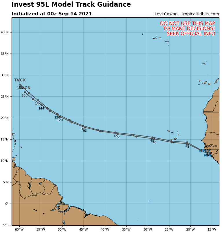
SouthFLTropics wrote:Why am I getting the feeling that this 00z run of the GFS is going to throw us a wild swing back to the west with a stronger system???


Sent from my iPhone using Tapatalk


So far it’s weak at 204 and sheared but not as badly as 6 or 12z runs
0 likes   

User avatar
Hurricaneman
Category 5
Category 5
Posts: 7284
Age: 43
Joined: Tue Aug 31, 2004 3:24 pm
Location: central florida

Re: ATL: INVEST 95L - Models

#70 Postby Hurricaneman » Tue Sep 14, 2021 12:06 am

I think the GFS is off, looks as if 95L is starting to rotate in the low levels even though broad when the GFS shows development at basically 2 days out, the GFS makes a low end tropical storm out of this when conditions are there for a lot more strengthening in the MDR so looking at the GFS it doesn’t really bundle the energy with multiple vortices and that’s why it keeps 95L weak when in fact looking at satellite I only really see one and it’s around 11.8 N
1 likes   

LarryWx
Category 5
Category 5
Posts: 5795
Joined: Sun Sep 07, 2003 2:04 pm
Location: GA

Re: ATL: INVEST 95L - Models

#71 Postby LarryWx » Tue Sep 14, 2021 1:23 am

0Z UKMET
TROPICAL DEPRESSION 95L ANALYSED POSITION : 15.7N 14.4W

ATCF IDENTIFIER : AL952021

LEAD CENTRAL MAXIMUM WIND
VERIFYING TIME TIME POSITION PRESSURE (MB) SPEED (KNOTS)
-------------- ---- -------- ------------- -------------
0000UTC 14.09.2021 0 15.7N 14.4W 1009 22
1200UTC 14.09.2021 12 CEASED TRACKING
0 likes   
Personal Forecast Disclaimer:
The posts in this forum are NOT official forecasts and should not be used as such. They are just the opinion of the poster and may or may not be backed by sound meteorological data. They are NOT endorsed by any professional institution or storm2k.org. For official information, please refer to the NHC and NWS products.

User avatar
Teban54
Category 5
Category 5
Posts: 1984
Joined: Sat May 19, 2018 1:19 pm

Re: ATL: INVEST 95L - Models

#72 Postby Teban54 » Tue Sep 14, 2021 2:41 am

Lol 0z Euro has this peak at 1012 mb.
0 likes   

User avatar
aspen
Category 5
Category 5
Posts: 8061
Joined: Sat Oct 12, 2019 7:10 pm
Location: Connecticut, USA

Re: ATL: INVEST 95L - Models

#73 Postby aspen » Tue Sep 14, 2021 4:31 am

All of the 00z models trended weaker, and only the ICON really shows any development. Seeing how 95L already has a good spin and might be within a day from being a TC, those runs are probably wrong; they don’t even show anything before the TUTT either.
1 likes   
Irene '11 Sandy '12 Hermine '16 5/15/2018 Derecho Fay '20 Isaias '20 Elsa '21 Henri '21 Ida '21

I am only a meteorology enthusiast who knows a decent amount about tropical cyclones. Look to the professional mets, the NHC, or your local weather office for the best information.

User avatar
kevin
Category 5
Category 5
Posts: 1793
Age: 25
Joined: Wed Aug 28, 2019 4:35 am

Re: ATL: INVEST 95L - Models

#74 Postby kevin » Tue Sep 14, 2021 4:45 am

06z ICON has a weak TS:

Image
0 likes   

User avatar
aspen
Category 5
Category 5
Posts: 8061
Joined: Sat Oct 12, 2019 7:10 pm
Location: Connecticut, USA

Re: ATL: INVEST 95L - Models

#75 Postby aspen » Tue Sep 14, 2021 5:48 am

06z GFS is another slow development and death-by-TUTT run. We can toss this solution out if 95L becomes TD15 or Odette within the next 48 hours, because this run takes until Friday to have something classifiable.
1 likes   
Irene '11 Sandy '12 Hermine '16 5/15/2018 Derecho Fay '20 Isaias '20 Elsa '21 Henri '21 Ida '21

I am only a meteorology enthusiast who knows a decent amount about tropical cyclones. Look to the professional mets, the NHC, or your local weather office for the best information.

User avatar
kevin
Category 5
Category 5
Posts: 1793
Age: 25
Joined: Wed Aug 28, 2019 4:35 am

Re: ATL: INVEST 95L - Models

#76 Postby kevin » Tue Sep 14, 2021 6:05 am

06z HWRF gets consistent TS winds (35+ kt) at 24 hours from now.
0 likes   

User avatar
SFLcane
S2K Supporter
S2K Supporter
Posts: 9627
Age: 46
Joined: Sat Jun 05, 2010 1:44 pm
Location: Lake Worth Florida

Re: ATL: INVEST 95L - Models

#77 Postby SFLcane » Tue Sep 14, 2021 6:33 am

Image
0 likes   

User avatar
aspen
Category 5
Category 5
Posts: 8061
Joined: Sat Oct 12, 2019 7:10 pm
Location: Connecticut, USA

Re: ATL: INVEST 95L - Models

#78 Postby aspen » Tue Sep 14, 2021 6:36 am

HWRF is slow like the GFS, but not as slow; 95L looks good on Thursday and would probably be TS Odette with that IR presentation.

Update: in the 990s by Saturday, and the environment looks decently favorable.
0 likes   
Irene '11 Sandy '12 Hermine '16 5/15/2018 Derecho Fay '20 Isaias '20 Elsa '21 Henri '21 Ida '21

I am only a meteorology enthusiast who knows a decent amount about tropical cyclones. Look to the professional mets, the NHC, or your local weather office for the best information.

User avatar
kevin
Category 5
Category 5
Posts: 1793
Age: 25
Joined: Wed Aug 28, 2019 4:35 am

Re: ATL: INVEST 95L - Models

#79 Postby kevin » Tue Sep 14, 2021 7:05 am

06z HWRF is slow but does eventually reach hurricane strength at +111.

Image

Image
0 likes   

User avatar
Blown Away
S2K Supporter
S2K Supporter
Posts: 9874
Joined: Wed May 26, 2004 6:17 am

Re: ATL: INVEST 95L - Models

#80 Postby Blown Away » Tue Sep 14, 2021 7:06 am

Image
Image

06z... TVCN near 20N/60W at end run, likely because of a weaker system,,,
0 likes   
Hurricane Eye Experience: David 79, Irene 99, Frances 04, Jeanne 04, Wilma 05... EYE COMING MY WAY IN 2024…
Hurricane Brush Experience: Andrew 92, Erin 95, Floyd 99, Matthew 16, Irma 17, Ian 22, Nicole 22…


Return to “2021”

Who is online

Users browsing this forum: No registered users and 2 guests