ATL: ELSA - Models

Moderator: S2k Moderators

Message
Author
USTropics
Category 5
Category 5
Posts: 2636
Joined: Sun Aug 12, 2007 3:45 am
Location: Florida State University

Re: ATL: ELSA - Models

#721 Postby USTropics » Sat Jul 03, 2021 12:19 am

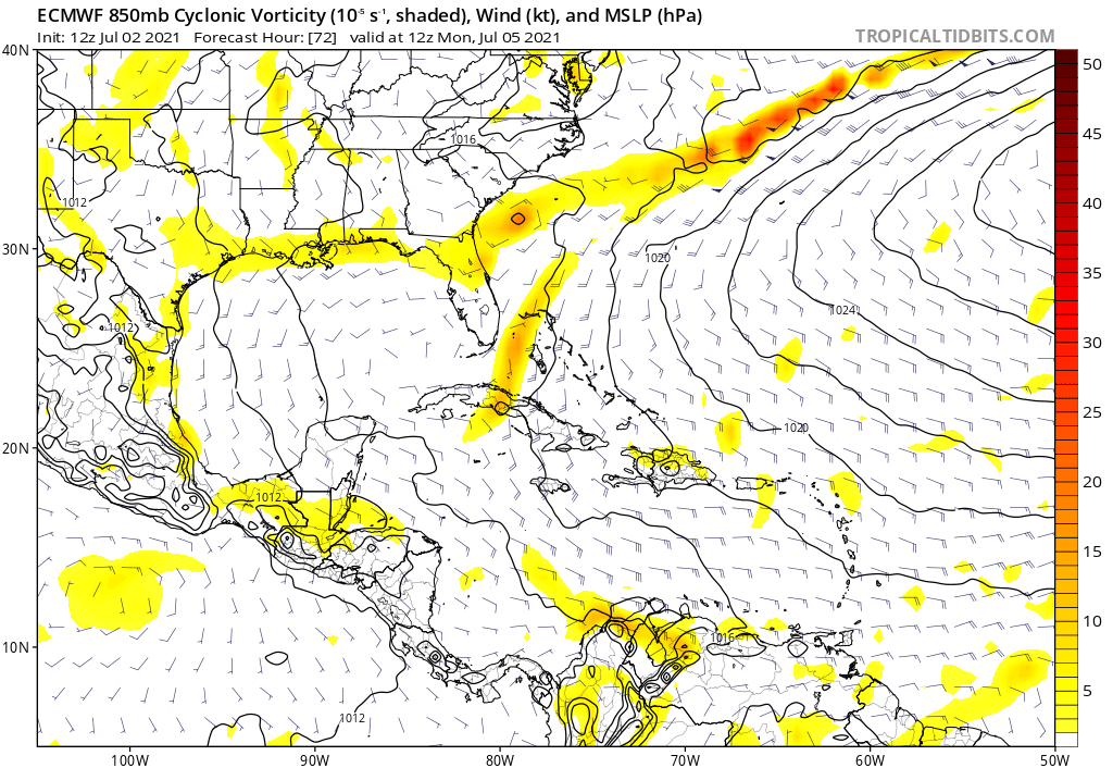
Category5Kaiju wrote:Yeah seems like the models are very confused, not entirely sure why though. This is going to be a critical night...

Also, assuming Elsa clips south Haiti, how mountainous exactly is that part of the country? I feel like very minute details of the terrain can matter especially in this kind of scenario.


Haiti
Image

Cuba
Image
3 likes   

AutoPenalti
Category 5
Category 5
Posts: 4029
Age: 28
Joined: Mon Aug 17, 2015 4:16 pm
Location: Ft. Lauderdale, Florida

Re: ATL: ELSA - Models

#722 Postby AutoPenalti » Sat Jul 03, 2021 12:20 am

HWRF seems weaker though. It’s further north.
0 likes   
The posts in this forum are NOT official forecasts and should not be used as such. They are just the opinion of the poster and may or may not be backed by sound meteorological data. They are NOT endorsed by any professional institution or STORM2K. For official information, please refer to products from the NHC and NWS.


Model Runs Cheat Sheet:
GFS (5:30 AM/PM, 11:30 AM/PM)
HWRF, GFDL, UKMET, NAVGEM (6:30-8:00 AM/PM, 12:30-2:00 AM/PM)
ECMWF (1:45 AM/PM)

TCVN
is a weighted averaged

User avatar
Blown Away
S2K Supporter
S2K Supporter
Posts: 10140
Joined: Wed May 26, 2004 6:17 am

Re: ATL: ELSA - Models

#723 Postby Blown Away » Sat Jul 03, 2021 12:22 am

AutoPenalti wrote:HWRF seems weaker though. It’s further north.


Only weaker near Cuba b/c it taking the land road, 50 miles N or S I bet HWRF shows a major hurricane. Does keep adjusting N over past few runs.
3 likes   
Hurricane Eye Experience: David 79, Irene 99, Frances 04, Jeanne 04, Wilma 05... EYE COMING MY WAY IN 2024…
Hurricane Brush Experience: Andrew 92, Erin 95, Floyd 99, Matthew 16, Irma 17, Ian 22, Nicole 22…

Nuno
Category 2
Category 2
Posts: 591
Joined: Fri Aug 30, 2019 8:35 am
Location: Coral Gables, FL

Re: ATL: ELSA - Models

#724 Postby Nuno » Sat Jul 03, 2021 12:23 am

eastcoastFL wrote:HWRF looks like it will take the long way across Cuba

https://www.tropicaltidbits.com/analysis/models/hwrf/2021070300/hwrf_ref_05L_14.png


Aka the "Ernesto"
3 likes   
Andrew (1992), Irene (1999), Frances (2004), Katrina (2005), Wilma (2005), Fay (2008), Irma (2017), Eta (2020), Ian (2022)

User avatar
Jr0d
S2K Supporter
S2K Supporter
Posts: 1394
Joined: Tue Aug 27, 2019 10:52 am
Location: Cayo Hueso

Re: ATL: ELSA - Models

#725 Postby Jr0d » Sat Jul 03, 2021 12:49 am

Blown Away wrote:
AutoPenalti wrote:HWRF seems weaker though. It’s further north.


Only weaker near Cuba b/c it taking the land road, 50 miles N or S I bet HWRF shows a major hurricane. Does keep adjusting N over past few runs.


I much rather the storm pass north of me than just south or west(Key West). For about 48 hours now we have been in the center of the forecast, now I am getting concerned. The intensity forecast is particularly annoying....such a small track change will be the difference between minimal tropical storm conditions to possible a major hurricane.

This is the first time the consensus has shifted right....time will tell if it is a trend. It seems like most storms that initially forecast to hit Florida end up being right of the early forecasts....I can only hope this trend continues.

While the latest HWRF is good news for the Florida Keys, it is certainly not set in stone. Hopefully by Sunday morning there is some confidence in the guidance so I can relax or finish my preparations.

I'm eagerly awaiting the next GFS run...hopefully it has the upper air data.
0 likes   

AxaltaRacing24
Category 5
Category 5
Posts: 1753
Age: 24
Joined: Wed Jul 27, 2016 11:14 am
Location: Jupiter, FL

Re: ATL: ELSA - Models

#726 Postby AxaltaRacing24 » Sat Jul 03, 2021 1:12 am

Jr0d wrote:
Blown Away wrote:
AutoPenalti wrote:HWRF seems weaker though. It’s further north.


Only weaker near Cuba b/c it taking the land road, 50 miles N or S I bet HWRF shows a major hurricane. Does keep adjusting N over past few runs.


I much rather the storm pass north of me than just south or west(Key West). For about 48 hours now we have been in the center of the forecast, now I am getting concerned. The intensity forecast is particularly annoying....such a small track change will be the difference between minimal tropical storm conditions to possible a major hurricane.

This is the first time the consensus has shifted right....time will tell if it is a trend. It seems like most storms that initially forecast to hit Florida end up being right of the early forecasts....I can only hope this trend continues.

While the latest HWRF is good news for the Florida Keys, it is certainly not set in stone. Hopefully by Sunday morning there is some confidence in the guidance so I can relax or finish my preparations.

I'm eagerly awaiting the next GFS run...hopefully it has the upper air data.

Storms in this kind of setup seem like they always tend to come in a bit more east than the final track shows.
Last edited by AxaltaRacing24 on Sat Jul 03, 2021 1:17 am, edited 2 times in total.
0 likes   

User avatar
Blown Away
S2K Supporter
S2K Supporter
Posts: 10140
Joined: Wed May 26, 2004 6:17 am

Re: ATL: ELSA - Models

#727 Postby Blown Away » Sat Jul 03, 2021 1:17 am

00z EURO... Finally shows up to the party... Basically follows current NHC track with lots of Cuba interaction and begins to deepen riding W coast of Florida...
0 likes   
Hurricane Eye Experience: David 79, Irene 99, Frances 04, Jeanne 04, Wilma 05... EYE COMING MY WAY IN 2024…
Hurricane Brush Experience: Andrew 92, Erin 95, Floyd 99, Matthew 16, Irma 17, Ian 22, Nicole 22…

User avatar
Kingarabian
S2K Supporter
S2K Supporter
Posts: 15827
Joined: Sat Aug 08, 2009 3:06 am
Location: Honolulu, Hawaii

Re: ATL: ELSA - Models

#728 Postby Kingarabian » Sat Jul 03, 2021 1:23 am

Ah king Euro
Image
6 likes   
RIP Kobe Bryant

Shell Mound
Category 5
Category 5
Posts: 2434
Age: 32
Joined: Thu Sep 07, 2017 3:39 pm
Location: St. Petersburg, FL → Scandinavia

Re: ATL: ELSA - Models

#729 Postby Shell Mound » Sat Jul 03, 2021 1:29 am

Kingarabian wrote:Ah king Euro
https://i.imgur.com/4cnCKc8.gif

Interestingly, this run shows Elsa weakening prior to landfall on the extreme western tip of the Tiburon Peninsula in Haiti. Yet the same run is also indicating more conducive conditions in the eastern Gulf of Mexico vs. the Caribbean. Nevertheless, this run is still among the strongest of the ECMWF to date, and evinces a significant upturn vs. previous runs, especially over the eastern GoM and Florida. So perhaps the ECMWF is seeing a favourable trough-interaction over the GoM, à la Charley (2004) or Michael (2018), albeit on a far less extreme scale.
0 likes   
CVW / MiamiensisWx / Shell Mound
The posts in this forum are NOT official forecasts and should not be used as such. They are just the opinion of the poster and may or may not be backed by sound meteorological data. They are NOT endorsed by any professional institution or STORM2K. For official information, please refer to products from the NHC and NWS.

redingtonbeach
Tropical Depression
Tropical Depression
Posts: 55
Joined: Mon Sep 04, 2017 12:05 am

Re: ATL: ELSA - Models

#730 Postby redingtonbeach » Sat Jul 03, 2021 1:38 am

Am I reading the models right - nearly 8" precipitation in CFL Tues-Wed?
3 likes   

User avatar
Blown Away
S2K Supporter
S2K Supporter
Posts: 10140
Joined: Wed May 26, 2004 6:17 am

Re: ATL: ELSA - Models

#731 Postby Blown Away » Sat Jul 03, 2021 1:45 am

redingtonbeach wrote:Am I reading the models right - nearly 8" precipitation in CFL Tues-Wed?


Most likely b/c FL Peninsula will be on the “dirty” side and Elsa will be moving a lot slower passing FL.
2 likes   
Hurricane Eye Experience: David 79, Irene 99, Frances 04, Jeanne 04, Wilma 05... EYE COMING MY WAY IN 2024…
Hurricane Brush Experience: Andrew 92, Erin 95, Floyd 99, Matthew 16, Irma 17, Ian 22, Nicole 22…

Shell Mound
Category 5
Category 5
Posts: 2434
Age: 32
Joined: Thu Sep 07, 2017 3:39 pm
Location: St. Petersburg, FL → Scandinavia

Re: ATL: ELSA - Models

#732 Postby Shell Mound » Sat Jul 03, 2021 1:53 am

The 00Z HWRF shifted eastward once again, moving the projected LF from Fort Myers (18Z) to Everglades City.

On this run, too, Elsa does deepen up until landfall, but is weaker vs. earlier due to more interaction with Cuba.
0 likes   
CVW / MiamiensisWx / Shell Mound
The posts in this forum are NOT official forecasts and should not be used as such. They are just the opinion of the poster and may or may not be backed by sound meteorological data. They are NOT endorsed by any professional institution or STORM2K. For official information, please refer to products from the NHC and NWS.

User avatar
Hammy
Category 5
Category 5
Posts: 5849
Age: 41
Joined: Fri May 25, 2012 5:25 pm
Contact:

Re: ATL: ELSA - Models

#733 Postby Hammy » Sat Jul 03, 2021 2:03 am

So are we getting a consensus now that Elsa may dissipate before Cuba, but also redevelop after? This really shows how unfavorable the overall surface flow in the central Caribbean is when you don't already have a high-end hurricane or lack 100% ideal atmospheric conditions.
0 likes   
The above post is not official and should not be used as such. It is the opinion of the poster and may or may not be backed by sound meteorological data. It is not endorsed by any professional institution or storm2k.org. For official information, please refer to the NHC and NWS products.

User avatar
Blown Away
S2K Supporter
S2K Supporter
Posts: 10140
Joined: Wed May 26, 2004 6:17 am

Re: ATL: ELSA - Models

#734 Postby Blown Away » Sat Jul 03, 2021 2:05 am

Subtle changes in the angle Elsa takes near Cuba may make a big difference for Florida.
1. Elsa rides below Cuba and crosses Cuba at a sharper angle near 81W she will likely be strong moving up W side of Florida.
2. Elsa takes a little sharper R and comes off N Cuba near 77W and would have time to strengthen before SFL.
3. Elsa goes E of Florida, not likely now, but still on table.
5 likes   
Hurricane Eye Experience: David 79, Irene 99, Frances 04, Jeanne 04, Wilma 05... EYE COMING MY WAY IN 2024…
Hurricane Brush Experience: Andrew 92, Erin 95, Floyd 99, Matthew 16, Irma 17, Ian 22, Nicole 22…

TimSmith
S2K Supporter
S2K Supporter
Posts: 15
Joined: Tue Aug 25, 2020 10:21 am

Re: ATL: ELSA - Models

#735 Postby TimSmith » Sat Jul 03, 2021 3:38 am

captainbarbossa19 wrote:
gatorcane wrote:Euro 72 hours, open wave off SE Florida coast:

https://i.postimg.cc/Hs9czmFy/ecmwf-uv850-vort-watl-4.png


It just keeps saying, "let it go Elsa! You are a monster!"


On behalf of about 20 million people and a bunch of tourists, let's hope it's smarter than all of us and that forecast cones to fruition: little bit upper shear + da shredder island = poof
Last edited by TimSmith on Sat Jul 03, 2021 7:31 pm, edited 1 time in total.
0 likes   

Cat5James
Category 1
Category 1
Posts: 417
Joined: Fri Sep 06, 2019 7:54 pm

Re: ATL: ELSA - Models

#736 Postby Cat5James » Sat Jul 03, 2021 5:03 am

06Z GFS brings a weak Tropical Storm off the coast of Naples early Tuesday. Eastward shift from previous run.
1 likes   

User avatar
Nimbus
Category 5
Category 5
Posts: 5274
Joined: Mon Jul 19, 2004 10:54 am

Re: ATL: ELSA - Models

#737 Postby Nimbus » Sat Jul 03, 2021 5:29 am

Euro and GFS are both in the gulf so the model cone is actually widening after the 00z run.
NHC now calling for more favorable conditions if Elsa stays off of Hispaniola.
BamD deep steering for a stronger storm is apparently more west than shallow layer steering?
0 likes   

User avatar
karenfromheaven
Tropical Storm
Tropical Storm
Posts: 171
Age: 70
Joined: Thu Sep 09, 2004 4:45 pm
Location: North Naples, FL

Re: ATL: ELSA - Models

#738 Postby karenfromheaven » Sat Jul 03, 2021 6:41 am

HAFS-B gives Elsa a severe thrashing in Haiti and Cuba, and tosses her remains ashore in Fort Myers:

Image
0 likes   

User avatar
Ivanhater
Storm2k Moderator
Storm2k Moderator
Posts: 11153
Age: 38
Joined: Fri Jul 01, 2005 8:25 am
Location: Pensacola

Re: ATL: ELSA - Models

#739 Postby Ivanhater » Sat Jul 03, 2021 7:12 am

Hwrf and Hmon already have this exiting the east coast of Florida and up the eastern seaboard early Wednesday morning. She is booking it.
0 likes   
Michael

hurricane2025
Tropical Storm
Tropical Storm
Posts: 206
Joined: Thu Apr 08, 2021 10:36 am

Re: ATL: ELSA - Models

#740 Postby hurricane2025 » Sat Jul 03, 2021 7:12 am

Good rain maker for Florida.
0 likes   


Return to “2021”

Who is online

Users browsing this forum: No registered users and 21 guests