ATL: SAM - Remnants - Discussion
Moderator: S2k Moderators
-
SouthFLTropics

- Category 5

- Posts: 4258
- Age: 50
- Joined: Thu Aug 14, 2003 8:04 am
- Location: Port St. Lucie, Florida
ATL: INVEST 98L - Discussion
I think a good analogy for this storm could be 1999's Hurricane Floyd. It could get close enough to give us a few nervous moments here in South Florida but I find it highly unlikely that it makes it all the way to our shore. A recurve through the Bahama's with a swipe or landfall on the Outer Banks is what I'd be betting on right now. Not saying it can't or won't come to Florida, just that it is really hard to go against climatology in late September/early October. It is very difficult to get a hit from the east this far into the season. Now if this were to somehow make it into the Caribbean, I would definitely be more concerned. We have recent history with a few October storms out of the Caribbean (Wilma and Matthew, I'm looking at you).
3 likes
Fourth Generation Florida Native
Personal Storm History: David 79, Andrew 92, Erin 95, Floyd 99, Irene 99, Frances 04, Jeanne 04, Wilma 05, Matthew 16, Irma 17, Ian 22, Nicole 22, Milton 24
Personal Storm History: David 79, Andrew 92, Erin 95, Floyd 99, Irene 99, Frances 04, Jeanne 04, Wilma 05, Matthew 16, Irma 17, Ian 22, Nicole 22, Milton 24
-
jaxfladude
- Category 5
- Posts: 1249
- Joined: Wed Aug 24, 2005 9:36 pm
- Location: Jacksonville, Fla
Re: ATL: INVEST 98L - Discussion
98L(Future Sam?) would be WISE to peacefully/mercifully head north OTS and visit Frodo beyond the Grey Havens.
1 likes
Stay safe y'all
-
SFLcane

- S2K Supporter

- Posts: 10281
- Age: 48
- Joined: Sat Jun 05, 2010 1:44 pm
- Location: Lake Worth Florida
Re: ATL: INVEST 98L - Models
Fancy1001 wrote:Could South Florida finally get its due?
Who knows lol.
I think it’s highly likely now this will develop next 1-2 days.
2 likes
-
InfernoFlameCat

- Category 5
- Posts: 2127
- Age: 22
- Joined: Mon Dec 14, 2020 10:52 am
- Location: Buford, GA
Re: ATL: INVEST 98L - Discussion

Still no true surface center but its getting closer.
0 likes
I am by no means a professional. DO NOT look at my forecasts for official information or make decisions based on what I post.
Goal: to become a registered expert over tropical and subtropical cyclones.
Goal: to become a registered expert over tropical and subtropical cyclones.
-
ElectricStorm

- Category 5
- Posts: 5147
- Age: 25
- Joined: Tue Aug 13, 2019 11:23 pm
- Location: Norman, OK
Re: ATL: INVEST 98L - Discussion
Convection continues to blow up. The HWRF shows convection exploding over the next day or so. We'll have to see if convection continues to fire. The potential for a strong hurricane is there with this one.
0 likes
B.S Meteorology, University of Oklahoma '25
Please refer to the NHC, NWS, or SPC for official information.
Please refer to the NHC, NWS, or SPC for official information.
-
cycloneye

- Admin

- Posts: 149505
- Age: 69
- Joined: Thu Oct 10, 2002 10:54 am
- Location: San Juan, Puerto Rico
Re: ATL: INVEST 98L - Discussion
SouthFLTropics wrote:I think a good analogy for this storm could be 1999's Hurricane Floyd. It could get close enough to give us a few nervous moments here in South Florida but I find it highly unlikely that it makes it all the way to our shore. A recurve through the Bahama's with a swipe or landfall on the Outer Banks is what I'd be betting on right now. Not saying it can't or won't come to Florida, just that it is really hard to go against climatology in late September/early October. It is very difficult to get a hit from the east this far into the season. Now if this were to somehow make it into the Caribbean, I would definitely be more concerned. We have recent history with a few October storms out of the Caribbean (Wilma and Matthew, I'm looking at you).
FYI= Moved your post to here.
2 likes
Visit the Caribbean-Central America Weather Thread where you can find at first post web cams,radars
and observations from Caribbean basin members Click Here
and observations from Caribbean basin members Click Here
-
SouthFLTropics
- Category 5
- Posts: 4258
- Age: 50
- Joined: Thu Aug 14, 2003 8:04 am
- Location: Port St. Lucie, Florida
Re: ATL: INVEST 98L - Discussion
cycloneye wrote:SouthFLTropics wrote:I think a good analogy for this storm could be 1999's Hurricane Floyd. It could get close enough to give us a few nervous moments here in South Florida but I find it highly unlikely that it makes it all the way to our shore. A recurve through the Bahama's with a swipe or landfall on the Outer Banks is what I'd be betting on right now. Not saying it can't or won't come to Florida, just that it is really hard to go against climatology in late September/early October. It is very difficult to get a hit from the east this far into the season. Now if this were to somehow make it into the Caribbean, I would definitely be more concerned. We have recent history with a few October storms out of the Caribbean (Wilma and Matthew, I'm looking at you).
FYI= Moved your post to here.
Thanks Luis... Keep an eye out down there. I think this may be a close call for you guys in PR.
1 likes
Fourth Generation Florida Native
Personal Storm History: David 79, Andrew 92, Erin 95, Floyd 99, Irene 99, Frances 04, Jeanne 04, Wilma 05, Matthew 16, Irma 17, Ian 22, Nicole 22, Milton 24
Personal Storm History: David 79, Andrew 92, Erin 95, Floyd 99, Irene 99, Frances 04, Jeanne 04, Wilma 05, Matthew 16, Irma 17, Ian 22, Nicole 22, Milton 24
-
AxaltaRacing24
- Category 5
- Posts: 1774
- Age: 25
- Joined: Wed Jul 27, 2016 11:14 am
- Location: Jupiter, FL
Re: ATL: INVEST 98L - Models
Fancy1001 wrote:Could South Florida finally get its due?
At this point, I think it's too little too late for a storm like Sam to get here. But honestly, who knows? We cannot control that stuff. When we eventually get a strike from the E or SE, we will be the first to know. It'll happen whenever it happens.
0 likes
-
BlowHard

- S2K Supporter
- Posts: 48
- Age: 67
- Joined: Thu Aug 27, 2015 9:15 pm
- Location: Vieques, PR/Swansea, MA
- Contact:
Re: ATL: INVEST 98L - Discussion
jaxfladude wrote:Is this invest something to watch for Caribbean and/or others including ConUS? Or is the current background state staying negative long enough for this invrst lifespan?
They all are. Always.
0 likes
I am not a professional and this is just my opinion. Always refer to the professionals for advice.
-
ScottNAtlanta

- Category 5
- Posts: 2535
- Joined: Sat May 25, 2013 3:11 pm
- Location: Atlanta, GA
Re: ATL: INVEST 98L - Discussion
I think what the models are seeing is a trough split where part dives to the south the other goes out and there is high pressure squeezed between the two. This is a pretty good pattern setup for trough splits
0 likes
The posts in this forum are NOT official forecast and should not be used as such. They are just the opinion of the poster and may or may not be backed by sound meteorological data. They are NOT endorsed by any professional institution or storm2k.org. For official information, please refer to the NHC and NWS products.
-
ScottNAtlanta
- Category 5
- Posts: 2535
- Joined: Sat May 25, 2013 3:11 pm
- Location: Atlanta, GA
Re: ATL: INVEST 98L - Discussion
BTW...who was it that mentioned the GFS known "out to sea" bias ? Who was it that said look for the GFS to correct west? 
2 likes
The posts in this forum are NOT official forecast and should not be used as such. They are just the opinion of the poster and may or may not be backed by sound meteorological data. They are NOT endorsed by any professional institution or storm2k.org. For official information, please refer to the NHC and NWS products.

Re: ATL: INVEST 98L - Discussion
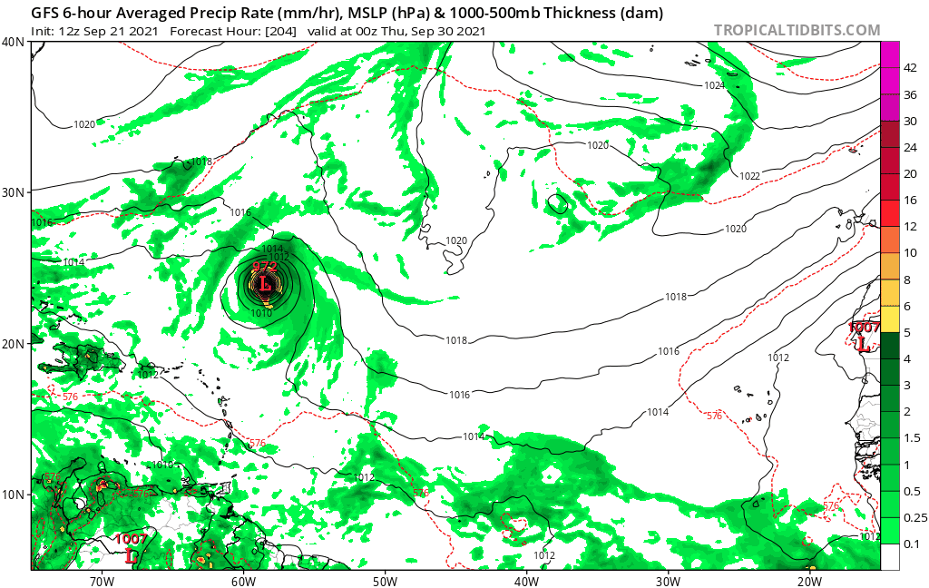
What is this, I'm not sure what you are trying to communicate with this graphic.?
0 likes
-
SFLcane
- S2K Supporter
- Posts: 10281
- Age: 48
- Joined: Sat Jun 05, 2010 1:44 pm
- Location: Lake Worth Florida
Re: ATL: INVEST 98L - Discussion
hipshot wrote:
What is this, I'm not sure what you are trying to communicate with this graphic.?
There’s gfs continues to under due ridging. Trending south
3 likes
-
Stormybajan

- Category 1

- Posts: 453
- Joined: Thu May 20, 2021 3:21 pm
- Location: Windward Islands
Re: ATL: INVEST 98L - Discussion
Hmm not sure if its just me but isnt 98L a bit north of most models at this moment? Looks to be just north of 10N, I know the 18z position was 9.5N 28.5W
1 likes
Sad West Indies and Manchester United fan ⚽️
-
jaxfladude
- Category 5
- Posts: 1249
- Joined: Wed Aug 24, 2005 9:36 pm
- Location: Jacksonville, Fla
Re: ATL: INVEST 98L - Discussion
Models need to start showing consistent runs of ots no landfall or island direct impacts solutions soon!!!
0 likes
Stay safe y'all
Re: ATL: INVEST 98L - Discussion
Showers and thunderstorms associated with a tropical wave located
several hundred miles southwest of the Cabo Verde Islands have
increased since this morning and are beginning to show signs of
organization. Recent satellite wind data also indicate that a broad
area of low pressure has formed, but the system lacks a well-defined
center. Environmental conditions are expected to remain conducive
for additional development, and a tropical depression is likely to
form within the next day or two while the system moves westward at
10 to 15 mph across the eastern and central tropical Atlantic Ocean.
* Formation chance through 48 hours...high...80 percent.
* Formation chance through 5 days...high...90 percent.
0 likes
-
cycloneye
- Admin
- Posts: 149505
- Age: 69
- Joined: Thu Oct 10, 2002 10:54 am
- Location: San Juan, Puerto Rico
Re: ATL: INVEST 98L - Discussion
A. TROPICAL DISTURBANCE (98L)
B. 21/2330Z
C. 10.7N
D. 29.5W
E. THREE/GOES-E
F. T2.5/2.5
G. IR/EIR/SWIR
H. REMARKS...5.5/10 BANDING AROUND THE LLCC YIELDS A DT OF 2.5. MET
AND PT AGREE AND ARE EQUAL TO 2.5 BASED ON A DEVELOPING TREND IN THE
LAST 24 HOURS. FT IS BASED ON DT.
I. ADDL POSITIONS
NIL
B. 21/2330Z
C. 10.7N
D. 29.5W
E. THREE/GOES-E
F. T2.5/2.5
G. IR/EIR/SWIR
H. REMARKS...5.5/10 BANDING AROUND THE LLCC YIELDS A DT OF 2.5. MET
AND PT AGREE AND ARE EQUAL TO 2.5 BASED ON A DEVELOPING TREND IN THE
LAST 24 HOURS. FT IS BASED ON DT.
I. ADDL POSITIONS
NIL
1 likes
Visit the Caribbean-Central America Weather Thread where you can find at first post web cams,radars
and observations from Caribbean basin members Click Here
and observations from Caribbean basin members Click Here
Who is online
Users browsing this forum: No registered users and 49 guests