EPAC: HILDA - Post-Tropical
Moderator: S2k Moderators

Re: EPAC: HILDA - Hurricane
Hilda is giving Barry and July 3rd Elsa a run for their money for the title of the ugliest thing to be called a hurricane.
0 likes
Irene '11 Sandy '12 Hermine '16 5/15/2018 Derecho Fay '20 Isaias '20 Elsa '21 Henri '21 Ida '21
I am only a meteorology enthusiast who knows a decent amount about tropical cyclones. Look to the professional mets, the NHC, or your local weather office for the best information.
I am only a meteorology enthusiast who knows a decent amount about tropical cyclones. Look to the professional mets, the NHC, or your local weather office for the best information.
-
Sciencerocks
- Category 5

- Posts: 7287
- Age: 38
- Joined: Thu Jul 06, 2017 1:51 am

-
cycloneye

- Admin

- Posts: 139241
- Age: 67
- Joined: Thu Oct 10, 2002 10:54 am
- Location: San Juan, Puerto Rico
Re: EPAC: HILDA - Hurricane
Hurricane Hilda Discussion Number 8
NWS National Hurricane Center Miami FL EP082021
800 AM PDT Sun Aug 01 2021
Hilda is a bit of a mess this morning with an elongated cloud
pattern from southeast to northwest and no signs of an eye in
conventional satellite imagery. However, microwave data near 1155
UTC from GPM still shows a well-defined low-level eye, although the
mid-level structure remains degraded from easterly shear. The
current wind speed is held at 75 kt, with this being an uncertain
estimate due to a large spread in the various intensity techniques.
Hilda is moving west-northwestward at about 7 kt, with microwave
data helping to pinpoint the slower movement. The track forecast is
no piece of cake this morning with some interaction anticipated with
Invest 91E to the east in a day or two. While a mid-level ridge
persists to the northwest of Hilda, the southern periphery of the
ridge weakens due to 91E, causing Hilda to take a northwestward
turn in a couple of days. Hilda then should turn back toward the
west-northwest and west by midweek due to the ridge remaining in
place and 91E weakening. This is a tricky forecast because the
guidance is shifting to the right, which at some point will bring
Hilda over cold waters and closer to 91E, changing which
atmospheric layers will dominate steering the tropical cyclone. In
addition, interactions between two systems this close together
aren't easy to forecast in the best of circumstances, and
the latest guidance isn't in great agreement on the future strength
of 91E either. As a compromise, the NHC track forecast is more
conservative in shifting the track to the northeast than the
guidance (remaining on the westerly side of the track envelope),
then gradually comes close to the previous NHC forecast by the end
of the 5-day period. This forecast is obviously rather uncertain,
and a lot of generally better performing aids are to the northeast
of the latest NHC track.
The hurricane still has some chance to intensify during the next day
or so with moderate easterly shear and good inner-core structure.
Still, it is becoming more likely that Hilda is close to its peak
intensity with no signs of the easterly shear abating until the
hurricane moves over cool waters in a few days. Model guidance
generally is lower than the last cycle, and only a few show
strengthening. I'm going to keep the chance for slight strengthening
in the near term, then show a steady drop in intensity due to
persistent (or stronger) easterly shear and marginal water
temperatures. The new intensity forecast is 5 kt lower than the
last one at 36 hours and beyond and that could still be too high,
especially if the track shifts any farther to the north.
FORECAST POSITIONS AND MAX WINDS
INIT 01/1500Z 14.6N 120.2W 75 KT 85 MPH
12H 02/0000Z 14.9N 121.2W 80 KT 90 MPH
24H 02/1200Z 15.4N 122.4W 80 KT 90 MPH
36H 03/0000Z 16.1N 123.4W 75 KT 85 MPH
48H 03/1200Z 16.9N 124.2W 70 KT 80 MPH
60H 04/0000Z 18.0N 125.5W 60 KT 70 MPH
72H 04/1200Z 19.0N 127.0W 50 KT 60 MPH
96H 05/1200Z 20.2N 131.2W 40 KT 45 MPH
120H 06/1200Z 20.5N 135.5W 30 KT 35 MPH...POST-TROP/REMNT LOW
$$
Forecaster Blake
0 likes
Visit the Caribbean-Central America Weather Thread where you can find at first post web cams,radars
and observations from Caribbean basin members Click Here
and observations from Caribbean basin members Click Here
-
Sciencerocks
- Category 5
- Posts: 7287
- Age: 38
- Joined: Thu Jul 06, 2017 1:51 am

-
Sciencerocks
- Category 5
- Posts: 7287
- Age: 38
- Joined: Thu Jul 06, 2017 1:51 am

-
cycloneye
- Admin
- Posts: 139241
- Age: 67
- Joined: Thu Oct 10, 2002 10:54 am
- Location: San Juan, Puerto Rico
Re: EPAC: HILDA - Hurricane
Hurricane Hilda Discussion Number 9
NWS National Hurricane Center Miami FL EP082021
200 PM PDT Sun Aug 01 2021
Hilda has had a similar appearance all day with an elongated cloud
pattern from southeast to northwest on satellite imagery. Recent
microwave passes show that the center is located on the northern
side of the central dense overcast. The current intensity estimates
have a very wide range from 65 to 90 kt, and with the apparent
steady-state of the hurricane, Hilda's wind speed will stay at 75 kt
until clearer data emerges.
Hilda continues moving west-northwestward at about 7 kt. The trends
from the last advisory have continued with more interaction shown
with new Tropical Depression 10-E to the east, leading to a weaker
ridge and a faster northwestward turn of Hilda in a day or so. By
midweek, Hilda should turn back to the west-northwest and westward
later in the period under the influence of a stronger portion of
the ridge. The new official forecast is shifted about a half a
degree to the northeast, near the model consensus, although the
corrected-consensus models are even farther to the right.
With the forecast track shift, it is becoming unlikely that Hilda
will get significantly stronger since it will move over cooler
waters sooner. In addition, easterly shear should increase
tomorrow, probably leading to the start of weakening. Guidance has
trended downward since the last cycle, and considering the new track
forecast moves over cooler waters faster, the latest NHC wind speed
forecast has been lowered 5-10 kt at all time periods, and this
still might be too high. In about 4 days, most of the models show
little convection remaining with Hilda due to cold water and drier
mid-level air, so the system should transition to a remnant low by
day 5.
FORECAST POSITIONS AND MAX WINDS
INIT 01/2100Z 14.8N 120.8W 75 KT 85 MPH
12H 02/0600Z 15.2N 121.8W 75 KT 85 MPH
24H 02/1800Z 15.8N 122.9W 75 KT 85 MPH
36H 03/0600Z 16.6N 123.7W 70 KT 80 MPH
48H 03/1800Z 17.6N 124.6W 60 KT 70 MPH
60H 04/0600Z 18.7N 125.8W 50 KT 60 MPH
72H 04/1800Z 19.6N 127.5W 45 KT 50 MPH
96H 05/1800Z 20.7N 131.6W 35 KT 40 MPH
120H 06/1800Z 21.0N 135.5W 25 KT 30 MPH...POST-TROP/REMNT LOW
$$
Forecaster Blake
0 likes
Visit the Caribbean-Central America Weather Thread where you can find at first post web cams,radars
and observations from Caribbean basin members Click Here
and observations from Caribbean basin members Click Here
-
SconnieCane
- Category 4

- Posts: 913
- Joined: Thu Aug 02, 2018 5:29 pm
- Location: Madison, WI
Re: EPAC: HILDA - Hurricane
aspen wrote:Hilda is giving Barry and July 3rd Elsa a run for their money for the title of the ugliest thing to be called a hurricane.
...and when it was first designated a 60kt TS and looked to be on the cusp of popping an eye, one could be forgiven for mistaking it for a 75-kt hurricane!
1 likes
-
AnnularCane

- S2K Supporter

- Posts: 2642
- Joined: Thu Jun 08, 2006 9:18 am
- Location: Wytheville, VA
Re: EPAC: HILDA - Hurricane
Hilda isn't even close to ugly, sorry. 
3 likes
"But it never rained rain. It never snowed snow. And it never blew just wind. It rained things like soup and juice. It snowed mashed potatoes and green peas. And sometimes the wind blew in storms of hamburgers." -- Judi Barrett, Cloudy with a Chance of Meatballs
-
Sciencerocks
- Category 5
- Posts: 7287
- Age: 38
- Joined: Thu Jul 06, 2017 1:51 am

-
cycloneye
- Admin
- Posts: 139241
- Age: 67
- Joined: Thu Oct 10, 2002 10:54 am
- Location: San Juan, Puerto Rico
Re: EPAC: HILDA - Hurricane
Hurricane Hilda Discussion Number 10
NWS National Hurricane Center Miami FL EP082021
800 PM PDT Sun Aug 01 2021
Hilda's satellite appearance is showing effects of easterly vertical
wind shear this evening. Recent imagery shows a sharp edge to the
upper-level outflow on the eastern side of the system. A 2130 UTC
AMSR2 microwave pass reveals that the eyewall is no longer closed,
as the inner core convection has been eroded on the eastern side of
the circulation. Microwave data also indicate the vortex has become
vertically tilted, with the mid-level center displaced about 10-15 n
mi to the west-northwest of the low-level center. Thus, the initial
intensity is lowered slightly to 70 kt for this advisory, in best
agreement with the objective UW-CIMSS Dvorak estimates.
Hilda is still moving west-northwestward at 285/8 kt, to the south
of a ridge over the western U.S. and northern Mexico. A turn to the
northwest is expected on Monday as the ridge weakens, likely in
response to T.D. Ten-E located to the east-northeast of Hilda. A
northwestward motion should continue through midweek before the
ridge becomes reestablished and Hilda turns westward through the
rest of the forecast period. There is greater track uncertainty
later in the week due to possible interaction with another system
that could redevelop from the remnants of T.D. Nine-E. The official
NHC track forecast has been adjusted to the right of the previous
one at 48 h and beyond based on the latest guidance, but it still
lies slightly left of the multi-model consensus aids TVCE and HCCA.
Environmental conditions are not expected to become any more
favorable for strengthening during the next couple days, so Hilda's
intensity has likely peaked. Moderate northeasterly shear is
forecast to persist for the next 36-48 h, and the NHC forecast track
brings Hilda north of the 26 deg C isotherm by the time these
upper-level winds subside. Once over cooler waters, Hilda is
forecast to quickly spin down and weaken to a tropical depression by
96 h. The NHC intensity forecast has again been lowered by 5-10 kt
from the previous one at all forecast times, but it still lies
slightly above the IVCN and HCCA consensus aids through 72 h. The
system is forecast to degenerate to a remnant low by day 5.
FORECAST POSITIONS AND MAX WINDS
INIT 02/0300Z 15.1N 121.6W 70 KT 80 MPH
12H 02/1200Z 15.5N 122.5W 70 KT 80 MPH
24H 03/0000Z 16.2N 123.4W 65 KT 75 MPH
36H 03/1200Z 17.3N 124.3W 60 KT 70 MPH
48H 04/0000Z 18.4N 125.3W 50 KT 60 MPH
60H 04/1200Z 19.5N 126.6W 40 KT 45 MPH
72H 05/0000Z 20.3N 128.3W 35 KT 40 MPH
96H 06/0000Z 21.0N 132.3W 25 KT 30 MPH
120H 07/0000Z 21.5N 136.0W 20 KT 25 MPH...POST-TROP/REMNT LOW
$$
Forecaster Reinhart/Pasch
0 likes
Visit the Caribbean-Central America Weather Thread where you can find at first post web cams,radars
and observations from Caribbean basin members Click Here
and observations from Caribbean basin members Click Here
-
Kingarabian

- S2K Supporter
- Posts: 15447
- Joined: Sat Aug 08, 2009 3:06 am
- Location: Honolulu, Hawaii
-
cycloneye
- Admin
- Posts: 139241
- Age: 67
- Joined: Thu Oct 10, 2002 10:54 am
- Location: San Juan, Puerto Rico
Re: EPAC: HILDA - Hurricane
Hurricane Hilda Discussion Number 11
NWS National Hurricane Center Miami FL EP082021
200 AM PDT Mon Aug 02 2021
SSMIS microwave data received just after the previous advisory
indicate that Hilda's structure may have improved slightly, with a
closed mid-level eye noted in the 85-GHz channel. However, the
microwave data also showed that the low- and mid-level centers
remain offset from each other by about 15 n mi due to continued
moderate easterly shear. The initial intensity remains 70 kt, which
is a blend of the latest final-T Dvorak numbers from TAFB and SAB.
Hilda has begun to turn to the right and slow down, and the initial
motion is west-northwestward (295 degrees) at 7 kt. Although the
subtropical ridge remains positioned to the north of Hilda, the
hurricane's close proximity to Tropical Depression Ten-E and the
remnants of Tropical Depression Nine-E is expected to cause some
binary interaction over the next couple of days, with Hilda likely
to slow down further and turn toward the northwest later today and
continue on that heading through Wednesday. In fact, the newest
track guidance has trended to the northeast during the first 48
hours, and the updated NHC forecast has therefore been shifted a
bit to the right during that period. However, it should be noted
that the track adjustment is conservative, and does not show a
turn quite as sharp as that shown by the TVCE and HCCA consensus
aids. Low-level ridging should play a more prominent role in about
3 days, causing Hilda to turn back toward the west-northwest and
then west by the end of the forecast period. No significant track
changes were required during the day 3-5 time period.
Moderate east-northeasterly shear is expected to continue for the
next 36 hours or so, with Hilda also heading toward cooler waters
during that time. Therefore, gradual weakening is expected to
commence later today, and the NHC intensity forecast is close to
the HCCA and ICON consensus aids for the next day or so. Sub-26
degree Celsius waters are likely to cause quicker weakening from 36
hours onward, and the NHC intensity forecast has been nudged
downward during that period. This new forecast is lower than the
statistical-dynamical models but not nearly as low as the latest
HCCA solution. Hilda is now forecast to weaken to a tropical
depression by day 3 and degenerate into a remnant low by day 4,
although the HCCA scenario suggests that these transitions could
occur as much as a day earlier.
FORECAST POSITIONS AND MAX WINDS
INIT 02/0900Z 15.3N 122.1W 70 KT 80 MPH
12H 02/1800Z 15.8N 122.7W 70 KT 80 MPH
24H 03/0600Z 16.7N 123.5W 65 KT 75 MPH
36H 03/1800Z 17.8N 124.3W 55 KT 65 MPH
48H 04/0600Z 18.9N 125.5W 45 KT 50 MPH
60H 04/1800Z 19.8N 127.0W 35 KT 40 MPH
72H 05/0600Z 20.5N 128.8W 30 KT 35 MPH
96H 06/0600Z 21.2N 132.6W 25 KT 30 MPH...POST-TROP/REMNT LOW
120H 07/0600Z 21.5N 136.5W 20 KT 25 MPH...POST-TROP/REMNT LOW
$$
Forecaster Berg
0 likes
Visit the Caribbean-Central America Weather Thread where you can find at first post web cams,radars
and observations from Caribbean basin members Click Here
and observations from Caribbean basin members Click Here
-
Yellow Evan

- Professional-Met

- Posts: 15956
- Age: 25
- Joined: Fri Jul 15, 2011 12:48 pm
- Location: Henderson, Nevada/Honolulu, HI
- Contact:
Re: EPAC: HILDA - Hurricane
TXPZ29 KNES 021156
TCSENP
A. 08E (HILDA)
B. 02/1130Z
C. 15.2N
D. 122.4W
E. THREE/GOES-W
F. T4.0/4.5
G. IR/EIR/SWIR/AMSR2
H. REMARKS...CENTER IS EMBEDDED IN MG RESULTING IN A DT OF 4.0. SAME DT
IS ACHIEVED USING AN EYE PATTERN. MET AND PT ARE ALSO 4.0. FT IS BASED
ON DT.
I. ADDL POSITIONS
02/0951Z 15.2N 122.0W AMSR2
...TURK
0 likes
-
cycloneye
- Admin
- Posts: 139241
- Age: 67
- Joined: Thu Oct 10, 2002 10:54 am
- Location: San Juan, Puerto Rico
Re: EPAC: HILDA - Hurricane
Hurricane Hilda Discussion Number 12
NWS National Hurricane Center Miami FL EP082021
800 AM PDT Mon Aug 02 2021
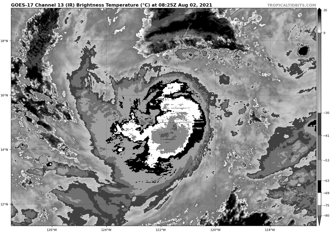
The satellite presentation of Hilda hasn't changed much in the past
several hours, with a round central dense overcast and perhaps a
ragged eye trying to form. The intensity estimates range from 60-77
kt, and since the hurricane's presentation is about the same as the
last advisory, the current wind speed will remain 70 kt. This is
one of those times that in situ reconnaissance data would be helpful
since there has been lots of spread in the intensity estimates for
quite some time, and Hilda is at an intensity where it is hard to
get more precise measurements.
The hurricane has finally turned northwestward and should continue
in that general direction for the next couple of days on the
southwestern side of the subtropical ridge, with some influence from
Ignacio to the northeast. Model guidance is in decent agreement
that Hilda will turn back to the west-northwest by midweek and then
west under the restrengthened subtropical ridge. While there are
still some outlier solutions, the latest consensus guidance is near
the previous NHC forecast, so only small changes were made on this
advisory.
Hilda is maintaining good inner-core structure on the latest
microwave data despite northeasterly shear (perhaps because of a
fairly moist mid-level environment around the hurricane), so little
intensity change is forecast for today. Thereafter, the system
should move over cooler waters into a drier environment, which
should cause gradual weakening for the next several days. Very
little change was made to the NHC intensity forecast, and it is
close to the HCCA and IVCN consensus aids throughout. Remnant-low
status is expected by 96 h, if not sooner.
FORECAST POSITIONS AND MAX WINDS
INIT 02/1500Z 15.4N 122.6W 70 KT 80 MPH
12H 03/0000Z 16.0N 123.1W 70 KT 80 MPH
24H 03/1200Z 16.9N 123.8W 60 KT 70 MPH
36H 04/0000Z 17.9N 124.7W 50 KT 60 MPH
48H 04/1200Z 18.9N 126.0W 40 KT 45 MPH
60H 05/0000Z 19.7N 127.5W 35 KT 40 MPH
72H 05/1200Z 20.4N 129.3W 30 KT 35 MPH
96H 06/1200Z 21.5N 133.9W 25 KT 30 MPH...POST-TROP/REMNT LOW
120H 07/1200Z 21.5N 138.5W 20 KT 25 MPH...POST-TROP/REMNT LOW
$$
Forecaster Blake
NWS National Hurricane Center Miami FL EP082021
800 AM PDT Mon Aug 02 2021
The satellite presentation of Hilda hasn't changed much in the past
several hours, with a round central dense overcast and perhaps a
ragged eye trying to form. The intensity estimates range from 60-77
kt, and since the hurricane's presentation is about the same as the
last advisory, the current wind speed will remain 70 kt. This is
one of those times that in situ reconnaissance data would be helpful
since there has been lots of spread in the intensity estimates for
quite some time, and Hilda is at an intensity where it is hard to
get more precise measurements.
The hurricane has finally turned northwestward and should continue
in that general direction for the next couple of days on the
southwestern side of the subtropical ridge, with some influence from
Ignacio to the northeast. Model guidance is in decent agreement
that Hilda will turn back to the west-northwest by midweek and then
west under the restrengthened subtropical ridge. While there are
still some outlier solutions, the latest consensus guidance is near
the previous NHC forecast, so only small changes were made on this
advisory.
Hilda is maintaining good inner-core structure on the latest
microwave data despite northeasterly shear (perhaps because of a
fairly moist mid-level environment around the hurricane), so little
intensity change is forecast for today. Thereafter, the system
should move over cooler waters into a drier environment, which
should cause gradual weakening for the next several days. Very
little change was made to the NHC intensity forecast, and it is
close to the HCCA and IVCN consensus aids throughout. Remnant-low
status is expected by 96 h, if not sooner.
FORECAST POSITIONS AND MAX WINDS
INIT 02/1500Z 15.4N 122.6W 70 KT 80 MPH
12H 03/0000Z 16.0N 123.1W 70 KT 80 MPH
24H 03/1200Z 16.9N 123.8W 60 KT 70 MPH
36H 04/0000Z 17.9N 124.7W 50 KT 60 MPH
48H 04/1200Z 18.9N 126.0W 40 KT 45 MPH
60H 05/0000Z 19.7N 127.5W 35 KT 40 MPH
72H 05/1200Z 20.4N 129.3W 30 KT 35 MPH
96H 06/1200Z 21.5N 133.9W 25 KT 30 MPH...POST-TROP/REMNT LOW
120H 07/1200Z 21.5N 138.5W 20 KT 25 MPH...POST-TROP/REMNT LOW
$$
Forecaster Blake
0 likes
Visit the Caribbean-Central America Weather Thread where you can find at first post web cams,radars
and observations from Caribbean basin members Click Here
and observations from Caribbean basin members Click Here
-
Sciencerocks
- Category 5
- Posts: 7287
- Age: 38
- Joined: Thu Jul 06, 2017 1:51 am

-
Yellow Evan
- Professional-Met
- Posts: 15956
- Age: 25
- Joined: Fri Jul 15, 2011 12:48 pm
- Location: Henderson, Nevada/Honolulu, HI
- Contact:
Re: EPAC: HILDA - Hurricane
If the colder cloud tops can wrap around given that this now clearing an eye and upper level outflow has improved, we could see a last moment sudden jump in intensity.
2 likes
-
Yellow Evan
- Professional-Met
- Posts: 15956
- Age: 25
- Joined: Fri Jul 15, 2011 12:48 pm
- Location: Henderson, Nevada/Honolulu, HI
- Contact:

-
Yellow Evan
- Professional-Met
- Posts: 15956
- Age: 25
- Joined: Fri Jul 15, 2011 12:48 pm
- Location: Henderson, Nevada/Honolulu, HI
- Contact:
Re: EPAC: HILDA - Hurricane

T4.5 with OW eye embedded in MG. If B can wrap fully around, T5.0.
0 likes
-
Sciencerocks
- Category 5
- Posts: 7287
- Age: 38
- Joined: Thu Jul 06, 2017 1:51 am

-
Yellow Evan
- Professional-Met
- Posts: 15956
- Age: 25
- Joined: Fri Jul 15, 2011 12:48 pm
- Location: Henderson, Nevada/Honolulu, HI
- Contact:

Who is online
Users browsing this forum: No registered users and 25 guests