https://ftp.nhc.noaa.gov/atcf/btk
ATL: WANDA - Post-Tropical - Discussion
Moderator: S2k Moderators
ATL: WANDA - Post-Tropical - Discussion
AL, 94, 2021102600, , BEST, 0, 330N, 746W, 40, 1002, LO, 34, NEQ, 40, 40, 0, 0, 1007, 100, 40, 0, 0, L, 0, , 0, 0, INVEST, M, 0, , 0, 0, 0, 0, genesis-num, 049, SPAWNINVEST, al742021 to al942021,
https://ftp.nhc.noaa.gov/atcf/btk
0 likes
-
Sciencerocks
- Category 5

- Posts: 10186
- Age: 40
- Joined: Thu Jul 06, 2017 1:51 am
Re: ATL: INVEST 94L - Discussion
Is this the first orange in October?
0 likes
TC naming lists: retirements and intensity
Most aggressive Advisory #1's in North Atlantic (cr. kevin for starting the list)
Most aggressive Advisory #1's in North Atlantic (cr. kevin for starting the list)
Re: ATL: INVEST 94L - Discussion
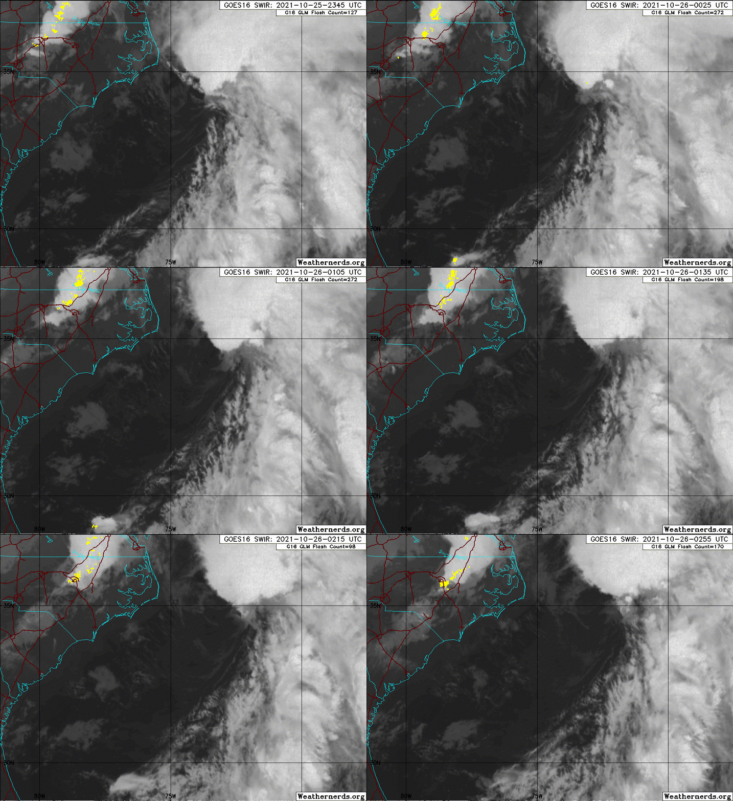
1. A deepening, non-tropical low pressure system with gale-force winds
is located about 250 miles east-northeast of Cape Hatteras, North
Carolina. This gale area is forecast to move north-northeastward
today, and could acquire some limited subtropical characteristics
before it merges with a frontal system by this afternoon. The
extratropical low is then expected to meander off the mid-Atlantic
and northeast U.S. coasts tonight and Wednesday, bringing rain and
wind impacts to portions of those areas. After that time, the low
is expected to move eastward away from the U.S. coast, and could
again acquire some subtropical characteristics while it moves
eastward or southeastward over the warmer waters of the central
Atlantic. For more information on this system, including storm
warnings, see products issued by your local National Weather Service
office and High Seas Forecasts issued by the National Weather
Service.
* Formation chance through 48 hours...low...20 percent.
* Formation chance through 5 days...medium...50 percent.
1 likes
TC naming lists: retirements and intensity
Most aggressive Advisory #1's in North Atlantic (cr. kevin for starting the list)
Most aggressive Advisory #1's in North Atlantic (cr. kevin for starting the list)
Re: ATL: INVEST 94L - Discussion
Teban54 wrote:Is this the first orange in October?
There was also 92L offshore the Outer Banks.
0 likes
Kendall -> SLO -> PBC
Memorable Storms: Katrina (for its Florida landfall...) Wilma Matthew Irma
Memorable Storms: Katrina (for its Florida landfall...) Wilma Matthew Irma
-
Sciencerocks
- Category 5

- Posts: 10186
- Age: 40
- Joined: Thu Jul 06, 2017 1:51 am
Re: ATL: INVEST 94L - Discussion
This storm sucks. If something of this magnitude happened in January instead of October, we’d likely be getting nearly a foot of snow. Driving conditions are garbage and are made worse by the covering of now-wet leaves on the road, and my university was having power issues; they didn’t have any during Ida despite its much higher rainfall.
0 likes
Irene '11 Sandy '12 Hermine '16 5/15/2018 Derecho Fay '20 Isaias '20 Elsa '21 Henri '21 Ida '21
I am only a meteorology enthusiast who knows a decent amount about tropical cyclones. Look to the professional mets, the NHC, or your local weather office for the best information.
I am only a meteorology enthusiast who knows a decent amount about tropical cyclones. Look to the professional mets, the NHC, or your local weather office for the best information.
-
Sciencerocks
- Category 5

- Posts: 10186
- Age: 40
- Joined: Thu Jul 06, 2017 1:51 am
- Hurricanehink
- S2K Supporter

- Posts: 2045
- Joined: Sun Nov 16, 2003 2:05 pm
- Location: New Jersey
Re: ATL: INVEST 94L - Discussion
Sciencerocks wrote:How does this compare to the perfect storm of 1991?
Two major differences. The 1991 storm originated from a nor’easter near Atlantic Canada, which moved southwestward. Second, the 1991 storm was fueled by the remnants of Hurricane Grace near Bermuda. The current storm is perhaps more reminiscent of Tropical Storm Melissa in 2019.
Here’s a satellite loop of the 1991 storm
[youtube]https://youtu.be/MQBq25SwWxM[/youtube]
Here’s a satellite loop of 2019’s Melissa
[youtube]https://youtu.be/sdCXdrTMmJk[/youtube]
3 likes
Re: ATL: INVEST 94L - Discussion
Impressive northeaster if nothing else, any time you get 30ft wave heights just offshore the storm has it going on.
https://www.ndbc.noaa.gov/station_page. ... tion=44029
https://www.ndbc.noaa.gov/station_page. ... tion=44029
5-day plot - Wind Direction Wind Direction (WDIR): NNE ( 30 deg true )
5-day plot - Wind Speed Wind Speed (WSPD): 38.9 kts
5-day plot - Wind Gust Wind Gust (GST): 50.5 kts
5-day plot - Wave Height Wave Height (WVHT): 32.2 ft
5-day plot - Dominant Wave Period Dominant Wave Period (DPD): 11 sec
5-day plot - Atmospheric Pressure Atmospheric Pressure (PRES): 29.31 in
5-day plot - Air Temperature Air Temperature (ATMP): 52.2 °F
5-day plot - Visibility Visibility (VIS) (0 to 1.6 nmi): 1.6 nmi
5-day plot - Wind Chill Wind Chill (CHILL): 43.5 °F
5-day plot - Wind Speed at 10 Meters Wind Speed at 10 meters (WSPD10M): 44.7 kts
5-day plot - Wind Speed at 10 Meters Wind Speed at 20 meters (WSPD20M): 48.6 kts
0 likes
Re: ATL: INVEST 94L - Discussion
Quite an impressive non-tropical low, but it needs to develop deep convection to tighten up its core if it ever wants to become a TC. Chances are already going down.
If the Mediterranean can produce a TC in October, surely the Nina-favored Atlantic should be able to.
If the Mediterranean can produce a TC in October, surely the Nina-favored Atlantic should be able to.
1 likes
Irene '11 Sandy '12 Hermine '16 5/15/2018 Derecho Fay '20 Isaias '20 Elsa '21 Henri '21 Ida '21
I am only a meteorology enthusiast who knows a decent amount about tropical cyclones. Look to the professional mets, the NHC, or your local weather office for the best information.
I am only a meteorology enthusiast who knows a decent amount about tropical cyclones. Look to the professional mets, the NHC, or your local weather office for the best information.
Re: ATL: INVEST 94L - Discussion
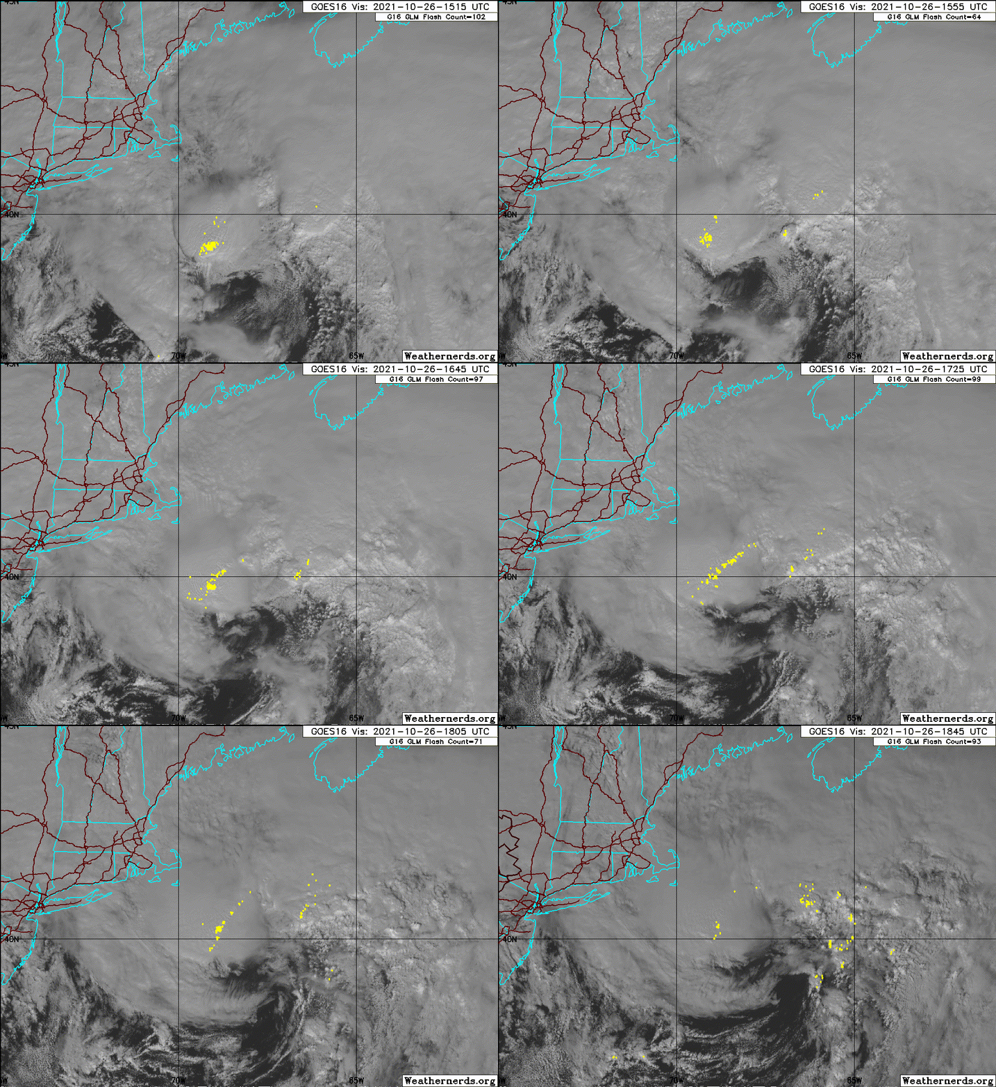
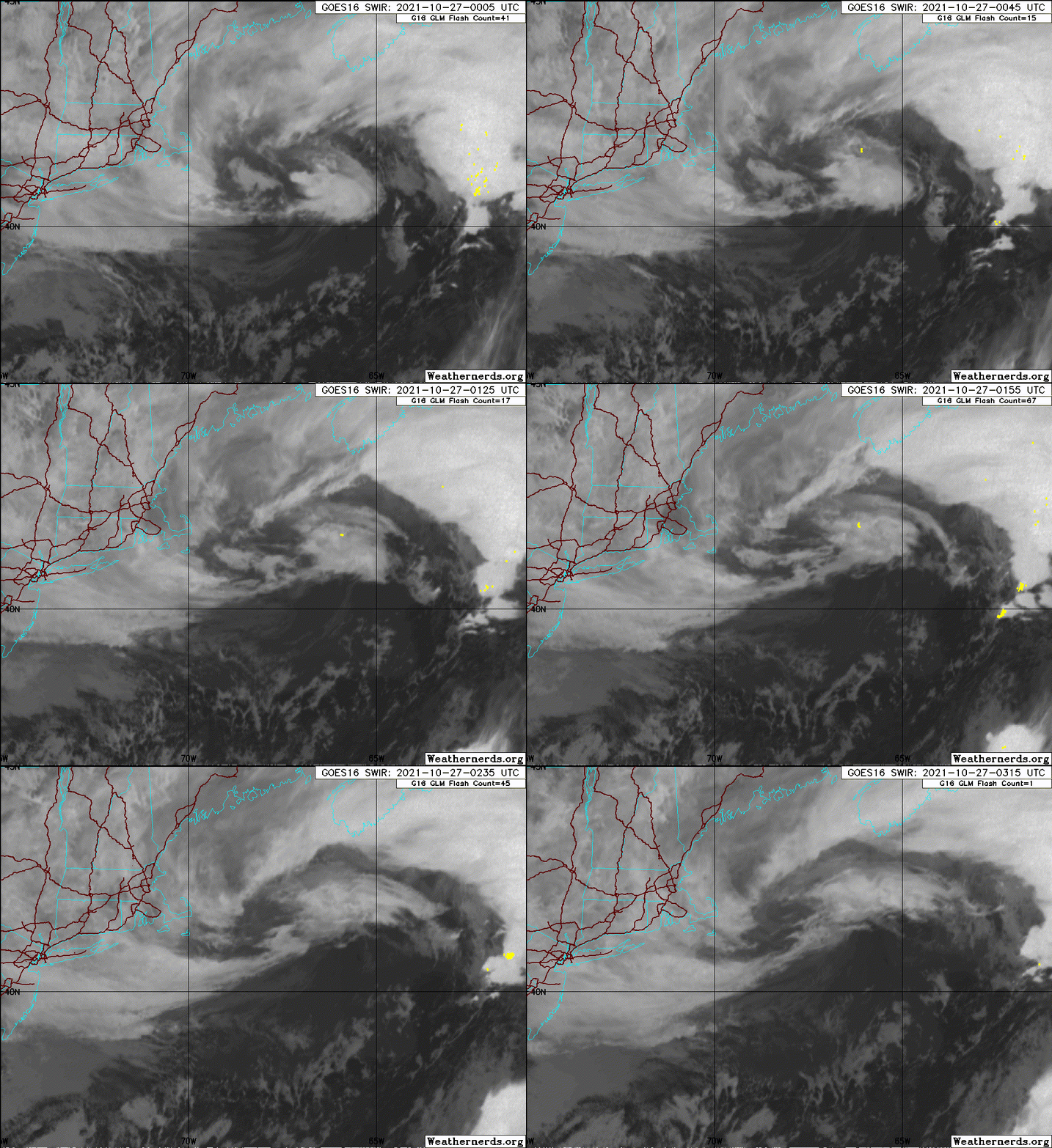
1. A deep, non-tropical low pressure system with storm-force winds is
centered more than 200 miles south-southeast of Cape Cod,
Massachusetts. The extratropical low is forecast to bring wind
impacts to portions of the northeastern U.S. coast for several more
hours as it begins to move eastward, away from the United States.
Thereafter, the low could acquire some subtropical characteristics
while it moves eastward or southeastward over the warmer waters of
the central Atlantic through this weekend. For more information on
this system, including storm warnings, see products issued by your
local National Weather Service office and High Seas Forecasts issued
by the National Weather Service.
* Formation chance through 48 hours...low...10 percent.
* Formation chance through 5 days...low...30 percent.
0 likes
TC naming lists: retirements and intensity
Most aggressive Advisory #1's in North Atlantic (cr. kevin for starting the list)
Most aggressive Advisory #1's in North Atlantic (cr. kevin for starting the list)
- skyline385
- Category 5

- Posts: 2728
- Age: 35
- Joined: Wed Aug 26, 2020 11:15 pm
- Location: Houston TX
Re: ATL: INVEST 94L - Discussion
aspen wrote:Quite an impressive non-tropical low, but it needs to develop deep convection to tighten up its core if it ever wants to become a TC. Chances are already going down.
If the Mediterranean can produce a TC in October, surely the Nina-favored Atlantic should be able to.
Well right now, the Atlantic doesn't seem to be acting like a Nina-favored one...
0 likes
Re: ATL: INVEST 94L - Discussion
skyline385 wrote:aspen wrote:Quite an impressive non-tropical low, but it needs to develop deep convection to tighten up its core if it ever wants to become a TC. Chances are already going down.
If the Mediterranean can produce a TC in October, surely the Nina-favored Atlantic should be able to.
Well right now, the Atlantic doesn't seem to be acting like a Nina-favored one...
The question is why, and whether or not it has to do with the state of this La Niña. If the 2021-22 Nina is going to behave differently than a normal Nina, then it’ll have major impacts for CONUS winter forecasts over the next several months.
0 likes
Irene '11 Sandy '12 Hermine '16 5/15/2018 Derecho Fay '20 Isaias '20 Elsa '21 Henri '21 Ida '21
I am only a meteorology enthusiast who knows a decent amount about tropical cyclones. Look to the professional mets, the NHC, or your local weather office for the best information.
I am only a meteorology enthusiast who knows a decent amount about tropical cyclones. Look to the professional mets, the NHC, or your local weather office for the best information.
-
hurricanes1234
- Category 5

- Posts: 2908
- Joined: Sat Jul 28, 2012 6:19 pm
- Location: Trinidad and Tobago
Re: ATL: INVEST 94L - Discussion
Down to 30% on the latest TWO. Another October 2021 bust.
0 likes
PLEASE NOTE: With the exception of information from weather agencies that I may copy and paste here, my posts will NEVER be official, since I am NOT a meteorologist. They are solely my amateur opinion, and may or may not be accurate. Therefore, please DO NOT use them as official details, particularly when making important decisions. Thank you.
- skyline385
- Category 5

- Posts: 2728
- Age: 35
- Joined: Wed Aug 26, 2020 11:15 pm
- Location: Houston TX
Re: ATL: INVEST 94L - Discussion
aspen wrote:skyline385 wrote:aspen wrote:Quite an impressive non-tropical low, but it needs to develop deep convection to tighten up its core if it ever wants to become a TC. Chances are already going down.
If the Mediterranean can produce a TC in October, surely the Nina-favored Atlantic should be able to.
Well right now, the Atlantic doesn't seem to be acting like a Nina-favored one...
The question is why, and whether or not it has to do with the state of this La Niña. If the 2021-22 Nina is going to behave differently than a normal Nina, then it’ll have major impacts for CONUS winter forecasts over the next several months.
That is the question on a lot of people's minds over here probably. I have been curious myself as well on how the winter plays out...
0 likes
-
Sciencerocks
- Category 5

- Posts: 10186
- Age: 40
- Joined: Thu Jul 06, 2017 1:51 am
-
jconsor
- Professional-Met

- Posts: 580
- Joined: Mon Jun 30, 2008 9:31 pm
- Location: Jerusalem, Israel
- Contact:
Re: ATL: INVEST 94L - Discussion
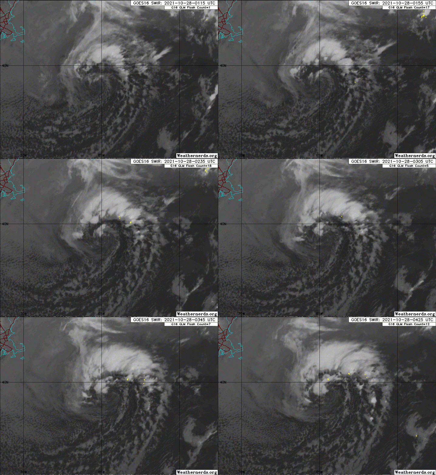
Thread on #94L which is gaining convection and will likely be named soon as a subtropical storm. It could briefly complete transition to tropical in the next day or two, before shear increases.
Wouldn't rule out the possibility it becomes a strong STS or hurricane by mid next week as shear decreases again, but first it has to weather the rapid ramp-up in shear over the weekend.
https://twitter.com/yconsor/status/1453690696695795722
https://twitter.com/yconsor/status/1453691896518303751
Wouldn't rule out the possibility it becomes a strong STS or hurricane by mid next week as shear decreases again, but first it has to weather the rapid ramp-up in shear over the weekend.
https://twitter.com/yconsor/status/1453690696695795722
https://twitter.com/yconsor/status/1453691896518303751
0 likes
-
tolakram
- Admin

- Posts: 20186
- Age: 62
- Joined: Sun Aug 27, 2006 8:23 pm
- Location: Florence, KY (name is Mark)
Re: ATL: INVEST 94L - Discussion
Saved loop


3 likes
M a r k
- - - - -
Join us in chat: Storm2K Chatroom Invite. Android and IOS apps also available.
The posts in this forum are NOT official forecasts and should not be used as such. Posts are NOT endorsed by any professional institution or STORM2K.org. For official information and forecasts, please refer to NHC and NWS products.
Who is online
Users browsing this forum: No registered users and 33 guests


