ATL: ALEX - Post-Tropical

Moderator: S2k Moderators

Message
Author
User avatar
weeniepatrol
Category 3
Category 3
Posts: 870
Joined: Sat Aug 22, 2020 5:30 pm
Location: WA State

Re: ATL: INVEST 91L - Discussion

#101 Postby weeniepatrol » Thu Jun 02, 2022 1:55 am

skyline385 wrote:2 AM outlook adds TS likelihood to the discussion


Good catch!
2 likes   

User avatar
Nimbus
Category 5
Category 5
Posts: 4933
Joined: Mon Jul 19, 2004 10:54 am

Re: ATL: INVEST 91L - Discussion

#102 Postby Nimbus » Thu Jun 02, 2022 4:17 am

Shear in the NW Carribean appears to be waning this morning.
If the TUT low further north off the Carolinas fills in the shear forecast could change.
That isn't forecast but its one of those 10% minority scenarios that has to be ignored until it isn't.

https://www.tropicaltidbits.com/sat/sat ... uct=wv_mid
0 likes   

User avatar
SFLcane
S2K Supporter
S2K Supporter
Posts: 9627
Age: 46
Joined: Sat Jun 05, 2010 1:44 pm
Location: Lake Worth Florida

Re: ATL: INVEST 91L - Discussion

#103 Postby SFLcane » Thu Jun 02, 2022 5:22 am

Curved band this morning on satellite. Still a work in progress but it’s getting there.

Image
0 likes   

cane5
Tropical Storm
Tropical Storm
Posts: 249
Joined: Fri Jul 02, 2021 4:24 pm

Re: ATL: INVEST 91L - Discussion

#104 Postby cane5 » Thu Jun 02, 2022 5:23 am

Can someone please issue a timeline to when they think the first bands will be reaching the Florida Peninsula…thank you.
0 likes   

jlauderdal
S2K Supporter
S2K Supporter
Posts: 6810
Joined: Wed May 19, 2004 5:46 am
Location: NE Fort Lauderdale
Contact:

Re: ATL: INVEST 91L - Discussion

#105 Postby jlauderdal » Thu Jun 02, 2022 5:32 am

2.13 in last night's rain event, over 5 since Saturday, NE Fort Lauderdale. South Florida has been worked over the last week so 5+ will cause issues. The precip output is worth looking at but it can't nail down training which is where the real action will be in this setup and it that could be from the keys to Central Florida, don't focus on landfall as it's not a wind event. Interesting to see the Euro and GFS trending toward a slower solution. Happy Hunting and make a donation to s2k, whatever you can you do, I made mine yesterday. Webhosting, etc. isn't free and when we get a big Atlantic system with 100s looking at the board and posting, it requires a robust hosting solution.
0 likes   

User avatar
wxman57
Moderator-Pro Met
Moderator-Pro Met
Posts: 22506
Age: 66
Joined: Sat Jun 21, 2003 8:06 pm
Location: Houston, TX (southwest)

Re: ATL: INVEST 91L - Discussion

#106 Postby wxman57 » Thu Jun 02, 2022 5:33 am

cane5 wrote:Can someone please issue a timeline to when they think the first bands will be reaching the Florida Peninsula…thank you.


By around 9am-10am tomorrow for the Keys, early afternoon for the southern Peninsula. Rain ending early afternoon Saturday as the center nears.
2 likes   

Chemmers
Tropical Storm
Tropical Storm
Posts: 199
Joined: Wed Jul 22, 2020 6:16 am

Re: ATL: INVEST 91L - Discussion

#107 Postby Chemmers » Thu Jun 02, 2022 6:07 am

Looks like wind shear is trying to back off, does anyone know if they are sending a recon today
0 likes   

jlauderdal
S2K Supporter
S2K Supporter
Posts: 6810
Joined: Wed May 19, 2004 5:46 am
Location: NE Fort Lauderdale
Contact:

Re: ATL: INVEST 91L - Discussion

#108 Postby jlauderdal » Thu Jun 02, 2022 6:10 am

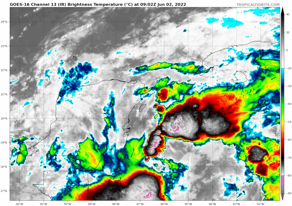
Chemmers wrote:Looks like wind shear is trying to back off, does anyone know if they are sending a recon today

It's planned but these things can change, I see no reason they wouldn't go today.

https://www.nhc.noaa.gov/text/MIAREPRPD.shtml


000
NOUS42 KNHC 011631
REPRPD
WEATHER RECONNAISSANCE FLIGHTS
CARCAH, NATIONAL HURRICANE CENTER, MIAMI, FL.
1230 PM EDT WED 01 JUNE 2022
SUBJECT: TROPICAL CYCLONE PLAN OF THE DAY (TCPOD)
VALID 02/1100Z TO 03/1100Z JUNE 2022
TCPOD NUMBER.....22-006

I. ATLANTIC REQUIREMENTS
1. SUSPECT AREA (NEAR YUCATAN PENINSULA)
FLIGHT ONE - TEAL 71 FLIGHT TWO - TEAL 72
A. 02/1800Z A. 03/0600Z
B. AFXXX 01AAA INVEST B. AFXXX 0201A CYCLONE
C. 02/1600Z C. 03/0400Z
D. 22.0N 86.5W D. 22.0N 86.5W
E. 02/1730Z TO 02/2130Z E. 03/0530Z TO 03/0900Z
F. SFC TO 10,000 FT F. SFC TO 10,000 FT
G. LOW-LEVEL INVEST G. FIX

FLIGHT THREE - TEAL 73
A. 03/1130Z,1730Z
B. AFXXX 0301A CYCLONE
C. 03/0915Z
D. 22.5N 86.0W
E. 03/1100Z TO 03/1730Z
F. SFC TO 10,000 FT
G. FIX

2. OUTLOOK FOR SUCCEEDING DAY: CONTINUE 6-HRLY FIXES IF
SYSTEM DEVELOPS AND IS A THREAT.

II. PACIFIC REQUIREMENTS
1. NEGATIVE RECONNAISSANCE REQUIREMENTS.
2. OUTLOOK FOR SUCCEEDING DAY.....NEGATIVE.

NOTE: THIS PRODUCT, THE TCPOD, OUTLINES TASKED NHC, CPHC, AND NCEP
OPERATIONAL WEATHER-RECONNAISSANCE FLYING REQUIREMENTS. IT WILL BE
ISSUED DAILY NO LATER THAN 1830 UTC THROUGH 30 NOVEMBER BY THE CHIEF,
AERIAL RECONNAISSANCE COORDINATION, ALL HURRICANES (CARCAH) UNIT OF THE
U.S. AIR FORCE RESERVE COMMAND'S 53RD WEATHER RECONNAISSANCE SQUADRON.

$$
WJM

NNNN
2 likes   

User avatar
wxman57
Moderator-Pro Met
Moderator-Pro Met
Posts: 22506
Age: 66
Joined: Sat Jun 21, 2003 8:06 pm
Location: Houston, TX (southwest)

Re: ATL: INVEST 91L - Discussion

#109 Postby wxman57 » Thu Jun 02, 2022 6:14 am

I'm surprised the NHC hasn't started PTC advisories yet, since squalls with possible TS winds may reach the keys tomorrow afternoon. Should be a TS watch out (or a warning).
8 likes   

User avatar
aspen
Category 5
Category 5
Posts: 8061
Joined: Sat Oct 12, 2019 7:10 pm
Location: Connecticut, USA

Re: ATL: INVEST 91L - Discussion

#110 Postby aspen » Thu Jun 02, 2022 6:55 am

wxman57 wrote:I'm surprised the NHC hasn't started PTC advisories yet, since squalls with possible TS winds may reach the keys tomorrow afternoon. Should be a TS watch out (or a warning).

Based on the 8am TWO, this will probably get labeled as PTC-1 sometime today. They said advisories might be needed later in the day, so they’ll most likely start PTC advisories at 5pm instead of 11am.
0 likes   
Irene '11 Sandy '12 Hermine '16 5/15/2018 Derecho Fay '20 Isaias '20 Elsa '21 Henri '21 Ida '21

I am only a meteorology enthusiast who knows a decent amount about tropical cyclones. Look to the professional mets, the NHC, or your local weather office for the best information.

User avatar
cycloneye
Admin
Admin
Posts: 139593
Age: 67
Joined: Thu Oct 10, 2002 10:54 am
Location: San Juan, Puerto Rico

Re: ATL: INVEST 91L - Discussion

#111 Postby cycloneye » Thu Jun 02, 2022 6:56 am

Near the Yucatan Peninsula and Southeastern Gulf of Mexico:
A broad area of low pressure located over the northeastern portion
of the Yucatan Peninsula continues to produce a large area of
disorganized showers and thunderstorms over the northwestern
Caribbean Sea and Yucatan Peninsula. Despite strong upper-level
winds, this system is likely to become a tropical depression or
tropical storm while it moves slowly northeastward over the
northwestern Caribbean Sea and southeastern Gulf of Mexico during
the next day or two. Interests in western Cuba, the Florida Keys,
and the Florida Peninsula should monitor the progress of this
system, and tropical storm watches or warnings could be required
for some of these areas later today.

1. Regardless of development, areas of heavy rainfall are likely
across portions of the Yucatan Peninsula and western Cuba during
the next day or so, spreading across southern and central Florida
and the Florida Keys Friday and Friday night, and the northwestern
Bahamas on Saturday. These heavy rains could cause scattered to
numerous flash floods across South Florida and the Florida Keys.
* Formation chance through 48 hours...high...80 percent.
* Formation chance through 5 days...high...80 percent.
0 likes   
Visit the Caribbean-Central America Weather Thread where you can find at first post web cams,radars
and observations from Caribbean basin members Click Here

User avatar
cycloneye
Admin
Admin
Posts: 139593
Age: 67
Joined: Thu Oct 10, 2002 10:54 am
Location: San Juan, Puerto Rico

Re: ATL: INVEST 91L - Discussion

#112 Postby cycloneye » Thu Jun 02, 2022 6:57 am

aspen wrote:
wxman57 wrote:I'm surprised the NHC hasn't started PTC advisories yet, since squalls with possible TS winds may reach the keys tomorrow afternoon. Should be a TS watch out (or a warning).

Based on the 8am TWO, this will probably get labeled as PTC-1 sometime today. They said advisories might be needed later in the day, so they’ll most likely start PTC advisories at 5pm instead of 11am.


Also, they may wait for the recon data this afternoon.
1 likes   
Visit the Caribbean-Central America Weather Thread where you can find at first post web cams,radars
and observations from Caribbean basin members Click Here

User avatar
cycloneye
Admin
Admin
Posts: 139593
Age: 67
Joined: Thu Oct 10, 2002 10:54 am
Location: San Juan, Puerto Rico

Re: ATL: INVEST 91L - Discussion

#113 Postby cycloneye » Thu Jun 02, 2022 7:02 am

Low just north of Cozumel.

A 1004 mb low pressure is centered just north of Cozumel, Mexico
near 21N87W at 0900 UTC, moving slowly northeastward. This low
is embedded within a broad area of low pressure that is located
near the east coast of the Yucatan Peninsula. Satellite imagery
shows disorganized clusters of scattered to numerous moderate to
isolated strong convection within this area of broad low
pressure over the waters north of 15N and west of 79W. Strong
east to southeast winds were highlighted by overnight ASCAT data
passes over this part of the Caribbean. Despite strong upper-
level winds, this system is likely to become a tropical
depression or tropical storm while it moves slowly northeastward
over the northwestern Caribbean Sea and southeastern Gulf of
Mexico during the next day or two. Interests in western Cuba,
the Florida Keys, and the Florida Peninsula should monitor the
progress of this system, and tropical storm watches or warnings
could be required for some of these areas later today. This
system has a high chance of becoming a tropical cyclone during
the next 48 hours.
0 likes   
Visit the Caribbean-Central America Weather Thread where you can find at first post web cams,radars
and observations from Caribbean basin members Click Here

User avatar
NDG
S2K Supporter
S2K Supporter
Posts: 14945
Joined: Sun Jul 09, 2006 10:14 pm
Location: Orlando, FL

Re: ATL: INVEST 91L - Discussion

#114 Postby NDG » Thu Jun 02, 2022 7:10 am

I am sure the recon this afternoon will find strong enough winds but the question is if it will find a well defined LLC, which as of this morning I don't see it yet.
SLPs have continued dropping during the past 24 hrs.
0 likes   

User avatar
toad strangler
S2K Supporter
S2K Supporter
Posts: 4178
Joined: Sun Jul 28, 2013 3:09 pm
Location: Earth
Contact:

Re: ATL: INVEST 91L - Discussion

#115 Postby toad strangler » Thu Jun 02, 2022 7:14 am

0 likes   

User avatar
ouragans
Category 1
Category 1
Posts: 468
Age: 52
Joined: Sun Jun 12, 2011 12:09 pm
Location: Abymes, Guadeloupe F.W.I
Contact:

Re: ATL: INVEST 91L - Discussion

#116 Postby ouragans » Thu Jun 02, 2022 7:25 am

My bet would be PTC at 11AM, then after Recon, TD or straight to TS at 5PM. First TS force winds are expected for Cuba in the next 36 hours, and next 48 hours for SoFla
0 likes   
Personal forecast disclaimer
This post is a personal point of view, not an information. Please refer to official statements for life-threatening decisions.

David '79, Frederic '79, Hugo '89, Iris, Luis & Marilyn '95, Georges '98, Lenny '99, Dean '07, Irma '17, Maria '17, Fiona '22, Philippe '23, Tammy '23
16°13'33.3,"6N -61°36'39.5"W

User avatar
NDG
S2K Supporter
S2K Supporter
Posts: 14945
Joined: Sun Jul 09, 2006 10:14 pm
Location: Orlando, FL

Re: ATL: INVEST 91L - Discussion

#117 Postby NDG » Thu Jun 02, 2022 7:38 am


CoC is definitely inland right now over the NE tip of the Yucatan P by looking at the radar loop and surface observations.

Image
2 likes   

User avatar
cycloneye
Admin
Admin
Posts: 139593
Age: 67
Joined: Thu Oct 10, 2002 10:54 am
Location: San Juan, Puerto Rico

Re: ATL: INVEST 91L - Discussion

#118 Postby cycloneye » Thu Jun 02, 2022 7:41 am

Low on NE tip of Yucatán.

Image
2 likes   
Visit the Caribbean-Central America Weather Thread where you can find at first post web cams,radars
and observations from Caribbean basin members Click Here

User avatar
cycloneye
Admin
Admin
Posts: 139593
Age: 67
Joined: Thu Oct 10, 2002 10:54 am
Location: San Juan, Puerto Rico

Re: ATL: INVEST 91L - Discussion

#119 Postby cycloneye » Thu Jun 02, 2022 7:49 am

Closeup.

Image
2 likes   
Visit the Caribbean-Central America Weather Thread where you can find at first post web cams,radars
and observations from Caribbean basin members Click Here

AutoPenalti
Category 5
Category 5
Posts: 3950
Age: 27
Joined: Mon Aug 17, 2015 4:16 pm
Location: Ft. Lauderdale, Florida

Re: ATL: INVEST 91L - Discussion

#120 Postby AutoPenalti » Thu Jun 02, 2022 7:50 am

Window for intensification is starting to close. Shear likely to pick up again tonight into tomorrow.
0 likes   
The posts in this forum are NOT official forecasts and should not be used as such. They are just the opinion of the poster and may or may not be backed by sound meteorological data. They are NOT endorsed by any professional institution or STORM2K. For official information, please refer to products from the NHC and NWS.


Model Runs Cheat Sheet:
GFS (5:30 AM/PM, 11:30 AM/PM)
HWRF, GFDL, UKMET, NAVGEM (6:30-8:00 AM/PM, 12:30-2:00 AM/PM)
ECMWF (1:45 AM/PM)

TCVN
is a weighted averaged


Return to “2022”

Who is online

Users browsing this forum: No registered users and 3 guests