Joe B thinks that Danielle will become a Major Hurricane later on.
https://twitter.com/BigJoeBastardi/status/1565398435443916804
ATL: DANIELLE - Post-Tropical - Discussion
Moderator: S2k Moderators
-
Iceresistance

- Category 5

- Posts: 9608
- Age: 22
- Joined: Sat Oct 10, 2020 9:45 am
- Location: Tecumseh, OK/Norman, OK
Re: ATL: DANIELLE - Tropical Storm
1 likes
Bill 2015 & Beta 2020
Winter 2020-2021
All observations are in Tecumseh, OK unless otherwise noted.
Winter posts are focused mainly for Oklahoma & Texas.
Take any of my forecasts with a grain of salt, refer to the NWS, SPC, and NHC for official information
Never say Never with weather! Because ANYTHING is possible!
Winter 2020-2021
All observations are in Tecumseh, OK unless otherwise noted.
Winter posts are focused mainly for Oklahoma & Texas.
Take any of my forecasts with a grain of salt, refer to the NWS, SPC, and NHC for official information
Never say Never with weather! Because ANYTHING is possible!
-
CrazyC83
- Professional-Met

- Posts: 34316
- Joined: Tue Mar 07, 2006 11:57 pm
- Location: Deep South, for the first time!
Re: ATL: DANIELLE - Tropical Storm
CDO coverage with embedded center in shallow cloud tops = T3.5?
0 likes
-
tolakram
- Admin

- Posts: 20186
- Age: 62
- Joined: Sun Aug 27, 2006 8:23 pm
- Location: Florence, KY (name is Mark)
Re: ATL: DANIELLE - Tropical Storm
I love storms like this. I can't do Dvorak but hopefully some other experts will chime in.
2 likes
M a r k
- - - - -
Join us in chat: Storm2K Chatroom Invite. Android and IOS apps also available.
The posts in this forum are NOT official forecasts and should not be used as such. Posts are NOT endorsed by any professional institution or STORM2K.org. For official information and forecasts, please refer to NHC and NWS products.


Re: ATL: DANIELLE - Tropical Storm
Earlier raw T #s could've been higher but it is curved band now, bit less symmetrical so harder for center fix. It's quite high latitude so cloud temps probably won't get too cold.
UW - CIMSS
ADVANCED DVORAK TECHNIQUE
ADT-Version 9.0
Tropical Cyclone Intensity Algorithm
----- Current Analysis -----
Date : 01 SEP 2022 Time : 222020 UTC
Lat : 38:06:06 N Lon : 44:27:06 W
CI# /Pressure/ Vmax
2.5 / 1002mb / 35kts
Final T# Adj T# Raw T#
2.4 2.5 2.5
Center Temp : -8.3C Cloud Region Temp : -47.5C
Scene Type : CURVED BAND with 0.54 ARC in LT GRAY
Subtropical Adjustment : OFF
Extratropical Adjustment : OFF
Positioning Method : FORECAST INTERPOLATION
Ocean Basin : ATLANTIC
Dvorak CI > MSLP Conversion Used : CKZ Method
Tno/CI Rules : Constraint Limits : NO LIMIT
Weakening Flag : ON
Rapid Dissipation Flag : OFF
0 likes
The above post and any post by Ntxw is NOT an official forecast and should not be used as such. It is just the opinion of the poster and may or may not be backed by sound meteorological data. It is NOT endorsed by any professional institution including Storm2k. For official information, please refer to NWS products.
Help support Storm2K!

-
cycloneye

- Admin
- Posts: 149727
- Age: 69
- Joined: Thu Oct 10, 2002 10:54 am
- Location: San Juan, Puerto Rico
ATL: DANIELLE - Tropical Storm - Discussion
TXNT21 KNES 020010
TCSNTL
A. 05L (DANIELLE)
B. 01/2330Z
C. 37.9N
D. 44.1W
E. THREE/GOES-E
F. T3.0/3.0
G. IR/EIR/SWIR
H. REMARKS...6.5/10 BANDING RESULTS IN A DT OF 3.0. THE MET IS 2.5 BASED
ON RAPID DEVELOPMENT TREND OVER THE PAST 24 HOURS. THE PT IS 3.0. THE
FT IS BASED ON THE PT DUE TO THE PULSING CONVECTION.
I. ADDL POSITIONS
NIL
...BROWN
0 likes
Visit the Caribbean-Central America Weather Thread where you can find at first post web cams,radars
and observations from Caribbean basin members Click Here
and observations from Caribbean basin members Click Here
-
galaxy401

- Category 5
- Posts: 2446
- Age: 30
- Joined: Sat Aug 25, 2012 9:04 pm
- Location: Casa Grande, Arizona
Re: ATL: DANIELLE - Tropical Storm - Discussion
^ That is Danielle's you posted.
0 likes
Got my eyes on moving right into Hurricane Alley: Florida.
-
cycloneye
- Admin
- Posts: 149727
- Age: 69
- Joined: Thu Oct 10, 2002 10:54 am
- Location: San Juan, Puerto Rico
Re: ATL: DANIELLE - Tropical Storm - Discussion
galaxy401 wrote:^ That is Danielle's you posted.
Yeah. Moved here.
0 likes
Visit the Caribbean-Central America Weather Thread where you can find at first post web cams,radars
and observations from Caribbean basin members Click Here
and observations from Caribbean basin members Click Here
-
ElectricStorm

- Category 5
- Posts: 5156
- Age: 25
- Joined: Tue Aug 13, 2019 11:23 pm
- Location: Norman, OK
Re: ATL: DANIELLE - Tropical Storm - Discussion
05L DANIELLE 220902 0000 38.0N 44.1W ATL 55 999
1 likes
B.S Meteorology, University of Oklahoma '25
Please refer to the NHC, NWS, or SPC for official information.
Please refer to the NHC, NWS, or SPC for official information.

Re: ATL: DANIELLE - Tropical Storm - Discussion
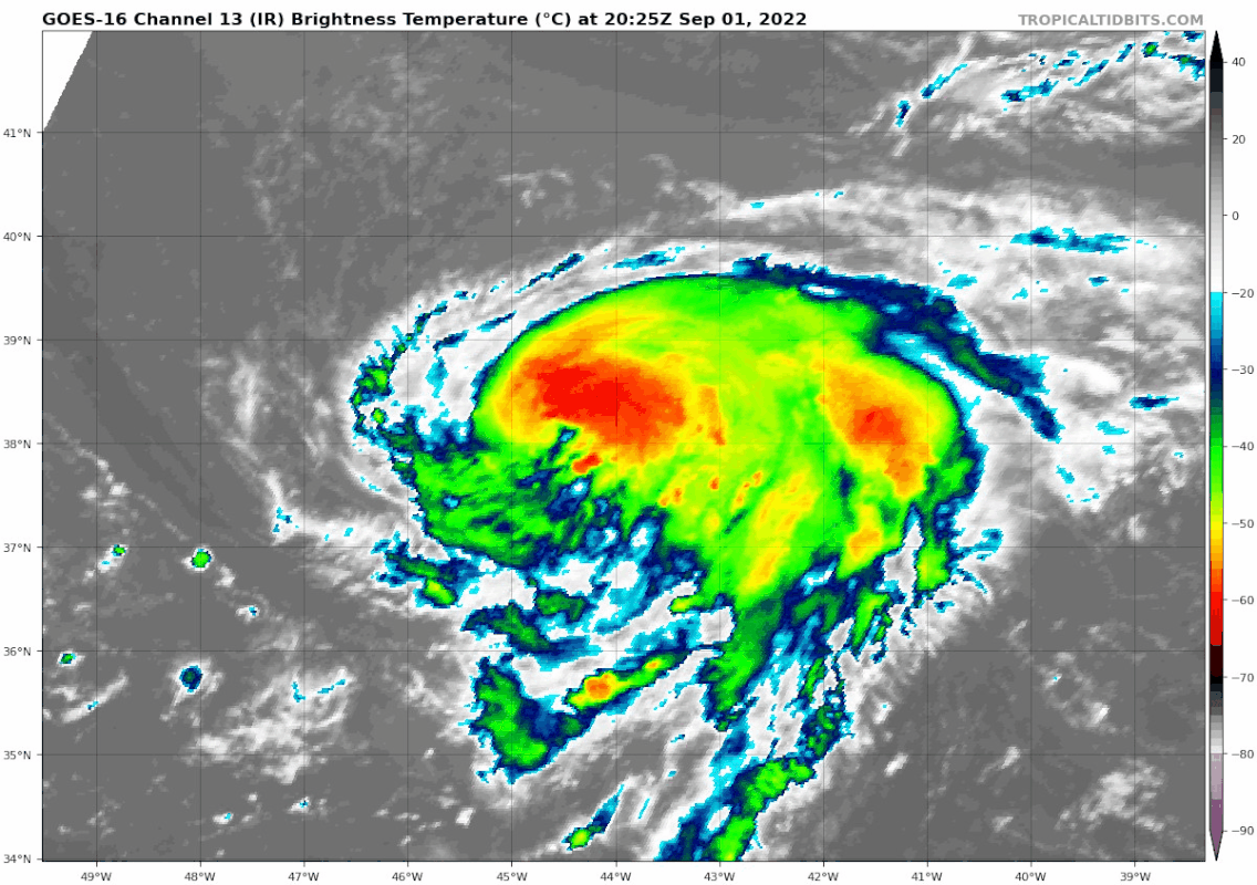
Not often do you see rotating hot towers at 38°N:
8 likes
TC naming lists: retirements and intensity
Most aggressive Advisory #1's in North Atlantic (cr. kevin for starting the list)
Most aggressive Advisory #1's in North Atlantic (cr. kevin for starting the list)
-
Sciencerocks
- Category 5
- Posts: 10193
- Age: 40
- Joined: Thu Jul 06, 2017 1:51 am


Re: ATL: DANIELLE - Tropical Storm - Discussion
55 kt is likely too low. This is probably a hurricane right now with those dual rotating hot towers. Unfortunately, the shallow convection typical of high latitude systems will make intensity estimates a little funky.
7 likes
Irene '11 Sandy '12 Hermine '16 5/15/2018 Derecho Fay '20 Isaias '20 Elsa '21 Henri '21 Ida '21
I am only a meteorology enthusiast who knows a decent amount about tropical cyclones. Look to the professional mets, the NHC, or your local weather office for the best information.
I am only a meteorology enthusiast who knows a decent amount about tropical cyclones. Look to the professional mets, the NHC, or your local weather office for the best information.
-
Hurricane Mike
- Category 2

- Posts: 675
- Joined: Tue Apr 10, 2018 7:44 am
Re: ATL: DANIELLE - Tropical Storm - Discussion
I wouldn't be surprised if Danielle cranks to 115 mph and becomes a major out to sea hurricane. Wait and see.
1 likes

Re: ATL: DANIELLE - Tropical Storm - Discussion
Seems like at least 70kt at the moment
0 likes
The above post is not official and should not be used as such. It is the opinion of the poster and may or may not be backed by sound meteorological data. It is not endorsed by any professional institution or storm2k.org. For official information, please refer to the NHC and NWS products.
Re: ATL: DANIELLE - Tropical Storm - Discussion
Oddly I think Danielle is the best looking storm globally at the moment. Hinnamnor is suffering from upwelling, and right now it looks like a shell of its former self.
1 likes
TC naming lists: retirements and intensity
Most aggressive Advisory #1's in North Atlantic (cr. kevin for starting the list)
Most aggressive Advisory #1's in North Atlantic (cr. kevin for starting the list)
-
CrazyC83
- Professional-Met
- Posts: 34316
- Joined: Tue Mar 07, 2006 11:57 pm
- Location: Deep South, for the first time!
Re: ATL: DANIELLE - Tropical Storm - Discussion
Current Intensity Analysis
UW - CIMSS
ADVANCED DVORAK TECHNIQUE
ADT-Version 9.0
Tropical Cyclone Intensity Algorithm
----- Current Analysis -----
Date : 02 SEP 2022 Time : 045024 UTC
Lat : 37:53:23 N Lon : 43:31:47 W
CI# /Pressure/ Vmax
2.8 / 999mb / 41kts
Final T# Adj T# Raw T#
2.8 3.1 5.2
Estimated radius of max. wind based on IR : 19 km
Center Temp : +11.4C Cloud Region Temp : -50.8C
Scene Type : EYE
Subtropical Adjustment : OFF
Extratropical Adjustment : OFF
Positioning Method : ARCHER POSITIONING
Ocean Basin : ATLANTIC
Dvorak CI > MSLP Conversion Used : CKZ Method
Tno/CI Rules : Constraint Limits : 0.5T/hour
Weakening Flag : OFF
Rapid Dissipation Flag : OFF
C/K/Z MSLP Estimate Inputs :
- Average 34 knot radii : 42nmi
- Environmental MSLP : 1018mb
Satellite Name : GOES16
Satellite Viewing Angle : 54.9 degrees
****************************************************
0 likes
-
CrazyC83
- Professional-Met
- Posts: 34316
- Joined: Tue Mar 07, 2006 11:57 pm
- Location: Deep South, for the first time!
Re: ATL: DANIELLE - Tropical Storm - Discussion
Since the water temperatures are about 28C despite its latitude, surface translation of winds shouldn't be an issue like with some other storms at high latitudes. That looks like T4.5 to me, and T5.0 if it can hold up for a while. I'd go with 75 kt and a Special Advisory.
2 likes
-
Kingarabian

- S2K Supporter

- Posts: 16379
- Joined: Sat Aug 08, 2009 3:06 am
- Location: Honolulu, Hawaii
Re: ATL: DANIELLE - Tropical Storm
CrazyC83 wrote:CDO coverage with embedded center in shallow cloud tops = T3.5?
If we add an eye feature (which there is), it's an easy 4.5. Per Dvorak, this is a Cat.2.
6 likes
RIP Kobe Bryant
-
CrazyC83
- Professional-Met
- Posts: 34316
- Joined: Tue Mar 07, 2006 11:57 pm
- Location: Deep South, for the first time!
Re: ATL: DANIELLE - Tropical Storm - Discussion
I wonder if the NHC is going to acknowledge the new developments with an upgrade or just wait until 09Z (5 am EDT)? They could either go with a Tropical Cyclone Update or a Special Advisory.
0 likes
-
Kingarabian
- S2K Supporter
- Posts: 16379
- Joined: Sat Aug 08, 2009 3:06 am
- Location: Honolulu, Hawaii
Re: ATL: DANIELLE - Tropical Storm - Discussion
Should be a special advisory for sure. I would go 85kts. IR/NightVIS show a clear eye. IR/VIS Eye means hurricane... Tropical storm's only have mid level microwave eyes.
1 likes
RIP Kobe Bryant
-
Extratropical94

- Professional-Met
- Posts: 3545
- Age: 31
- Joined: Wed Oct 20, 2010 6:36 am
- Location: Hamburg, Germany
- Contact:
Re: ATL: DANIELLE - Tropical Storm - Discussion
Still not a hurricane as per 06Z Best Track
AL, 05, 2022090206, , BEST, 0, 379N, 436W, 60, 996, TS
0 likes
54° 11' 59'' N, 9° 9' 20'' E
Boomer Sooner!
Go Broncos! Go Cards!
Clinching counties, one at a time: https://mob-rule.com/user-gifs/USA/xtrp94.gif
- Daniel
Boomer Sooner!
Go Broncos! Go Cards!
Clinching counties, one at a time: https://mob-rule.com/user-gifs/USA/xtrp94.gif
- Daniel
Who is online
Users browsing this forum: No registered users and 48 guests