
ATL: FIONA - Models
Moderator: S2k Moderators
-
tolakram
- Admin

- Posts: 20186
- Age: 62
- Joined: Sun Aug 27, 2006 8:23 pm
- Location: Florence, KY (name is Mark)
Re: ATL: SEVEN - Models
CMC goes south, way south (end of run).
0 likes
M a r k
- - - - -
Join us in chat: Storm2K Chatroom Invite. Android and IOS apps also available.
The posts in this forum are NOT official forecasts and should not be used as such. Posts are NOT endorsed by any professional institution or STORM2K.org. For official information and forecasts, please refer to NHC and NWS products.
-
ElectricStorm

- Category 5

- Posts: 5147
- Age: 25
- Joined: Tue Aug 13, 2019 11:23 pm
- Location: Norman, OK
Re: ATL: SEVEN - Models
12z HWRF blows it up into a hurricane, HMON very weak and much further south
0 likes
B.S Meteorology, University of Oklahoma '25
Please refer to the NHC, NWS, or SPC for official information.
Please refer to the NHC, NWS, or SPC for official information.

-
skyline385

- Category 5
- Posts: 2728
- Age: 35
- Joined: Wed Aug 26, 2020 11:15 pm
- Location: Houston TX


Re: ATL: SEVEN - Models
Interesting feature developing off the NE CONUS and moving SW on that run. Not sure what to make of it.
So far the CMC is the outlier with the others take it north.
0 likes


Re: ATL: SEVEN - Models
Fancy1001 wrote:Is anyone else laughing at the GFS run
I had a good laugh. It’s always good to be in the bulls eye 10 days out
3 likes

Re: ATL: SEVEN - Models
12z Euro reminds me of Isaias, with its general path (NECar into Bahamas and up) and interaction with Hispaniola.
0 likes
Irene '11 Sandy '12 Hermine '16 5/15/2018 Derecho Fay '20 Isaias '20 Elsa '21 Henri '21 Ida '21
I am only a meteorology enthusiast who knows a decent amount about tropical cyclones. Look to the professional mets, the NHC, or your local weather office for the best information.
I am only a meteorology enthusiast who knows a decent amount about tropical cyclones. Look to the professional mets, the NHC, or your local weather office for the best information.
-
AtlanticWind

- S2K Supporter

- Posts: 1898
- Age: 67
- Joined: Sun Aug 08, 2004 9:57 pm
- Location: Plantation,Fla
Re: ATL: SEVEN - Models
Models showing pretty big differences in upper air pattern one run to the next in the 144 hours+
I wouldnt put too much stock in the long range at this point.
I wouldnt put too much stock in the long range at this point.
2 likes
-
AutoPenalti
- Category 5
- Posts: 4091
- Age: 29
- Joined: Mon Aug 17, 2015 4:16 pm
- Location: Ft. Lauderdale, Florida
Re: ATL: SEVEN - Models
Euro recurves.
If you prefer the more dominant global models, it's favoring a sharp turn north somewhere after the Islands...
If you prefer the more dominant global models, it's favoring a sharp turn north somewhere after the Islands...
Last edited by AutoPenalti on Wed Sep 14, 2022 1:57 pm, edited 1 time in total.
0 likes
The posts in this forum are NOT official forecasts and should not be used as such. They are just the opinion of the poster and may or may not be backed by sound meteorological data. They are NOT endorsed by any professional institution or STORM2K. For official information, please refer to products from the NHC and NWS.
Model Runs Cheat Sheet:
GFS (5:30 AM/PM, 11:30 AM/PM)
HWRF, GFDL, UKMET, NAVGEM (6:30-8:00 AM/PM, 12:30-2:00 AM/PM)
ECMWF (1:45 AM/PM)
TCVN is a weighted averaged
Re: ATL: SEVEN - Models
12z ukmet ends at roughly the same place the 12z euro has it at 144 hours. Best bet right now is into Hispaniola then a right turn through the se Bahamas, probably will recurve after that, but hard to be sure right now. 5pm track probably will start to show the curve north at the end. 12z euro does bend east a lot more toward Bermuda though and doesn't get as far north although hard to tell if its a cyclonic loop or not with the ECFAST 24 hour blocks.
0 likes
-
AutoPenalti
- Category 5
- Posts: 4091
- Age: 29
- Joined: Mon Aug 17, 2015 4:16 pm
- Location: Ft. Lauderdale, Florida
Re: ATL: SEVEN - Models
0 likes
The posts in this forum are NOT official forecasts and should not be used as such. They are just the opinion of the poster and may or may not be backed by sound meteorological data. They are NOT endorsed by any professional institution or STORM2K. For official information, please refer to products from the NHC and NWS.
Model Runs Cheat Sheet:
GFS (5:30 AM/PM, 11:30 AM/PM)
HWRF, GFDL, UKMET, NAVGEM (6:30-8:00 AM/PM, 12:30-2:00 AM/PM)
ECMWF (1:45 AM/PM)
TCVN is a weighted averaged
-
AtlanticWind
- S2K Supporter
- Posts: 1898
- Age: 67
- Joined: Sun Aug 08, 2004 9:57 pm
- Location: Plantation,Fla

Re: ATL: SEVEN - Models
So the Euro with a general left/west bias recurves early, GFS with a recurve bias goes up the coast, and Canadian with a general east/right bias goes into the Gulf 
8 likes
The above post is not official and should not be used as such. It is the opinion of the poster and may or may not be backed by sound meteorological data. It is not endorsed by any professional institution or storm2k.org. For official information, please refer to the NHC and NWS products.


-
AutoPenalti
- Category 5
- Posts: 4091
- Age: 29
- Joined: Mon Aug 17, 2015 4:16 pm
- Location: Ft. Lauderdale, Florida
Re: ATL: SEVEN - Models
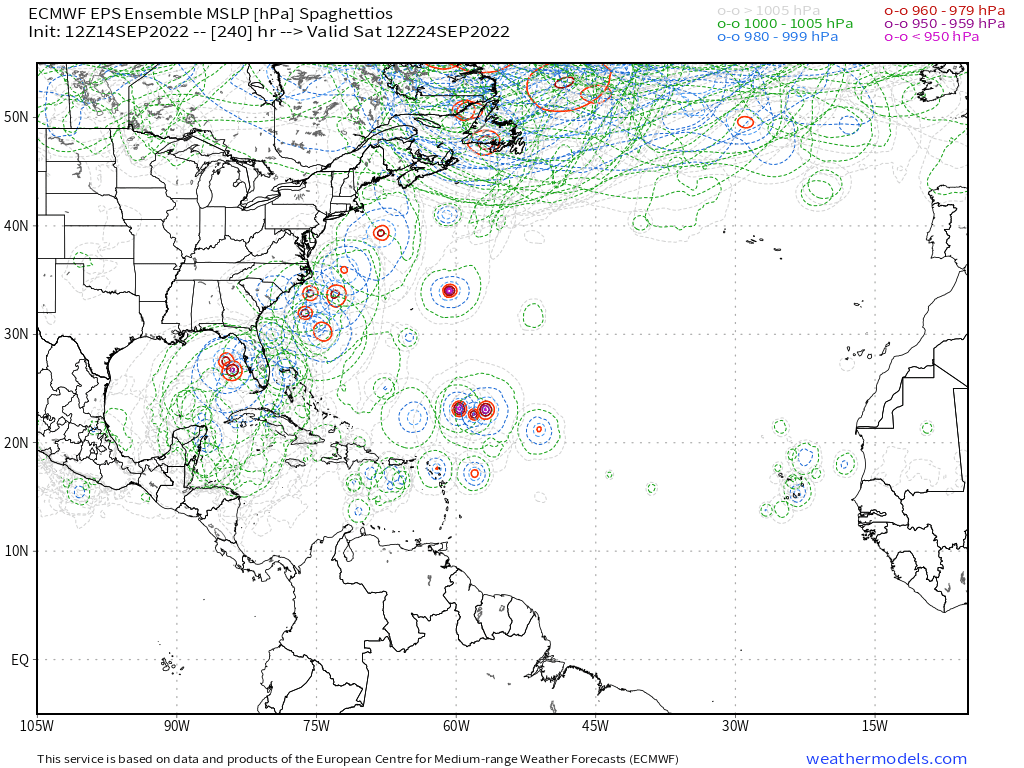
The Euro ensembles with a huge spread.
0 likes
The posts in this forum are NOT official forecasts and should not be used as such. They are just the opinion of the poster and may or may not be backed by sound meteorological data. They are NOT endorsed by any professional institution or STORM2K. For official information, please refer to products from the NHC and NWS.
Model Runs Cheat Sheet:
GFS (5:30 AM/PM, 11:30 AM/PM)
HWRF, GFDL, UKMET, NAVGEM (6:30-8:00 AM/PM, 12:30-2:00 AM/PM)
ECMWF (1:45 AM/PM)
TCVN is a weighted averaged
Re: ATL: SEVEN - Models
AutoPenalti wrote:The Euro ensembles with a huge spread.
https://pbs.twimg.com/media/Fco878wXgAYmkG8.png
That's about as huge a spread as you can get. This is definitely a job for LarryWx.
1 likes
Re: ATL: SEVEN - Models
18z earlies, notale that the TVCN shifted to curve from Hispaniola to over Puerto Rico and Stays east of the Bahamas. NHC track probably shifts right at 5PM, although not a whole lot since the GFS may be a bit too fast.

Last edited by BobHarlem on Wed Sep 14, 2022 3:07 pm, edited 2 times in total.
1 likes
-
skyline385
- Category 5
- Posts: 2728
- Age: 35
- Joined: Wed Aug 26, 2020 11:15 pm
- Location: Houston TX
Re: ATL: SEVEN - Models
EPS 12Z, lots of spread as mentioned above

Sent from my iPhone using Tapatalk
Sent from my iPhone using Tapatalk
0 likes

Re: ATL: SEVEN - Models
BobHarlem wrote:18z earlies, notale that the TVCN shifted to curve from Hispaniola to over Puerto Rico and Stays east of the Bahamas. NHC track probably shifts right at 5PM, although not a whole lot since the GFS may be a bit too fast.
https://i.imgur.com/8ezdCtu.gif
CMC is alone on an island. I'm curious why it thinks that ridge will be more potent and shunts this thing that far west.
0 likes
Personal Forecast Disclaimer:
The posts in this forum are NOT official forecast and should not be used as such. They are just the opinion of the poster and may or may not be backed by sound meteorological data. They are NOT endorsed by any professional institution or storm2k.org. For official information, please refer to the NHC and NWS products.
The posts in this forum are NOT official forecast and should not be used as such. They are just the opinion of the poster and may or may not be backed by sound meteorological data. They are NOT endorsed by any professional institution or storm2k.org. For official information, please refer to the NHC and NWS products.
Re: ATL: SEVEN - Models
AutoPenalti wrote:The Euro ensembles with a huge spread.
https://pbs.twimg.com/media/Fco878wXgAYmkG8.png
To clarify, those 12Z EPS members at 240 which are located from NE of PR to the LAs to those MHs NE of the Leewards as well as those S of PR and Hisp. in the Caribbean are actually from the AEW now just off Africa.
0 likes
Personal Forecast Disclaimer:
The posts in this forum are NOT official forecasts and should not be used as such. They are just the opinion of the poster and may or may not be backed by sound meteorological data. They are NOT endorsed by any professional institution or storm2k.org. For official information, please refer to the NHC and NWS products.
The posts in this forum are NOT official forecasts and should not be used as such. They are just the opinion of the poster and may or may not be backed by sound meteorological data. They are NOT endorsed by any professional institution or storm2k.org. For official information, please refer to the NHC and NWS products.
Who is online
Users browsing this forum: No registered users and 33 guests