ATL: FIONA - Post-Tropical - Discussion
Moderator: S2k Moderators
-
bob rulz
- Category 5

- Posts: 1711
- Age: 36
- Joined: Sat Jan 28, 2006 7:30 pm
- Location: Salt Lake City, Utah
Re: ATL: FIONA - Hurricane - Discussion
This is going to be one massive hurricane once it gets through an EWRC
0 likes
-
Hurricaneman

- Category 5
- Posts: 7404
- Age: 45
- Joined: Tue Aug 31, 2004 3:24 pm
- Location: central florida
Re: ATL: FIONA - Hurricane - Discussion
This doesn’t seem to be intensifying as quickly as some thought it would and my thought on that is Hispaniola is limiting the inflow but that problem should be gone by tomorrow, hope this avoids Bermuda and hope Atlantic Canada doesn’t get a nasty surprise
0 likes
-
ElectricStorm

- Category 5
- Posts: 5147
- Age: 25
- Joined: Tue Aug 13, 2019 11:23 pm
- Location: Norman, OK
Re: ATL: FIONA - Hurricane - Discussion
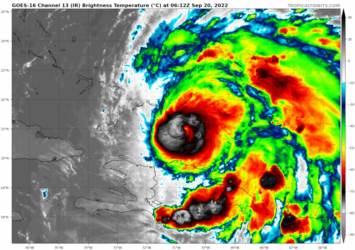
UW - CIMSS
ADVANCED DVORAK TECHNIQUE
ADT-Version 9.0
Tropical Cyclone Intensity Algorithm
----- Current Analysis -----
Date : 20 SEP 2022 Time : 042020 UTC
Lat : 20:46:48 N Lon : 70:32:24 W
CI# /Pressure/ Vmax
6.0 / 944mb / 115kts
Final T# Adj T# Raw T#
6.0 6.1 6.1
Estimated radius of max. wind based on IR : 6 km
Center Temp : -2.2C Cloud Region Temp : -67.7C
Also recon hasn't updated in 40min
EDIT: finally updated. Whoa 963.7 extrap
Last edited by ElectricStorm on Tue Sep 20, 2022 12:12 am, edited 2 times in total.
0 likes
B.S Meteorology, University of Oklahoma '25
Please refer to the NHC, NWS, or SPC for official information.
Please refer to the NHC, NWS, or SPC for official information.
-
TheDreamTraveler

- Category 2

- Posts: 645
- Joined: Sun Aug 22, 2010 3:10 am
- Location: PA
Re: ATL: FIONA - Hurricane - Discussion
Fiona is absolutely impressive looking right now especially so soon after coming off the Domican Republic
0 likes

Re: ATL: FIONA - Hurricane - Discussion
Hurricaneman wrote:This doesn’t seem to be intensifying as quickly as some thought it would and my thought on that is Hispaniola is limiting the inflow but that problem should be gone by tomorrow, hope this avoids Bermuda and hope Atlantic Canada doesn’t get a nasty surprise
Global models showed more gradual strengthening--only the hurricane models (as always) showed explosive intensification.
0 likes
The above post is not official and should not be used as such. It is the opinion of the poster and may or may not be backed by sound meteorological data. It is not endorsed by any professional institution or storm2k.org. For official information, please refer to the NHC and NWS products.
-
ElectricStorm
- Category 5
- Posts: 5147
- Age: 25
- Joined: Tue Aug 13, 2019 11:23 pm
- Location: Norman, OK
Re: ATL: FIONA - Hurricane - Discussion
Eye drop has 967mb at 0m so pressure continues to fall. Winds look about the same as earlier on that pass but it's probably not too far away from becoming a major, maybe at the 4am advisory
0 likes
B.S Meteorology, University of Oklahoma '25
Please refer to the NHC, NWS, or SPC for official information.
Please refer to the NHC, NWS, or SPC for official information.
Re: ATL: FIONA - Hurricane - Discussion
Some dry air entrainment going on it looks like, mostly coming off of Hispaniola, probably keeping it in check.

0 likes
The above post is not official and should not be used as such. It is the opinion of the poster and may or may not be backed by sound meteorological data. It is not endorsed by any professional institution or storm2k.org. For official information, please refer to the NHC and NWS products.
-
cheezyWXguy

- Category 5
- Posts: 6282
- Joined: Mon Feb 13, 2006 12:29 am
- Location: Dallas, TX
Re: ATL: FIONA - Hurricane - Discussion
Hammy wrote:Some dry air entrainment going on it looks like, mostly coming off of Hispaniola, probably keeping it in check.
https://i.imgur.com/MOz0i5x.png
I bet the large number of prominent bands competing with the core is holding things up a bit too
1 likes
-
ElectricStorm
- Category 5
- Posts: 5147
- Age: 25
- Joined: Tue Aug 13, 2019 11:23 pm
- Location: Norman, OK
Re: ATL: FIONA - Hurricane - Discussion
Eyewall is starting to approach some of those small islands. Hopefully anyone there is prepared and ready
0 likes
B.S Meteorology, University of Oklahoma '25
Please refer to the NHC, NWS, or SPC for official information.
Please refer to the NHC, NWS, or SPC for official information.
-
ElectricStorm
- Category 5
- Posts: 5147
- Age: 25
- Joined: Tue Aug 13, 2019 11:23 pm
- Location: Norman, OK
Re: ATL: FIONA - Hurricane - Discussion
BULLETIN
Hurricane Fiona Intermediate Advisory Number 23A
NWS National Hurricane Center Miami FL AL072022
200 AM EDT Tue Sep 20 2022
...FIONA BECOMES A MAJOR HURRICANE AS IT APPROACHES THE TURKS AND
CAICOS ISLANDS...
...HEAVY RAINFALL AND LIFE-THREATENING FLASH FLOODING STILL
OCCURRING IN EASTERN PORTIONS OF THE DOMINICAN REPUBLIC...
SUMMARY OF 200 AM EDT...0600 UTC...INFORMATION
----------------------------------------------
LOCATION...20.9N 70.8W
ABOUT 45 MI...70 KM SSE OF GRAND TURK ISLAND
MAXIMUM SUSTAINED WINDS...115 MPH...185 KM/H
PRESENT MOVEMENT...NNW OR 330 DEGREES AT 10 MPH...17 KM/H
MINIMUM CENTRAL PRESSURE...967 MB...28.56 INCHES
7 likes
B.S Meteorology, University of Oklahoma '25
Please refer to the NHC, NWS, or SPC for official information.
Please refer to the NHC, NWS, or SPC for official information.
-
MarioProtVI
- Category 5
- Posts: 1034
- Age: 24
- Joined: Sun Sep 29, 2019 7:33 pm
- Location: New Jersey
Re: ATL: FIONA - Hurricane - Discussion
ElectricStorm wrote:BULLETIN
Hurricane Fiona Intermediate Advisory Number 23A
NWS National Hurricane Center Miami FL AL072022
200 AM EDT Tue Sep 20 2022
...FIONA BECOMES A MAJOR HURRICANE AS IT APPROACHES THE TURKS AND
CAICOS ISLANDS...
...HEAVY RAINFALL AND LIFE-THREATENING FLASH FLOODING STILL
OCCURRING IN EASTERN PORTIONS OF THE DOMINICAN REPUBLIC...
SUMMARY OF 200 AM EDT...0600 UTC...INFORMATION
----------------------------------------------
LOCATION...20.9N 70.8W
ABOUT 45 MI...70 KM SSE OF GRAND TURK ISLAND
MAXIMUM SUSTAINED WINDS...115 MPH...185 KM/H
PRESENT MOVEMENT...NNW OR 330 DEGREES AT 10 MPH...17 KM/H
MINIMUM CENTRAL PRESSURE...967 MB...28.56 INCHES
She finally did what Earl couldn’t do.
3 likes
-
Jelmergraaff
- Tropical Storm

- Posts: 138
- Age: 23
- Joined: Fri Aug 27, 2021 1:00 pm
- Location: The Netherlands
Re: ATL: FIONA - Hurricane - Discussion
ElectricStorm wrote:BULLETIN
Hurricane Fiona Intermediate Advisory Number 23A
NWS National Hurricane Center Miami FL AL072022
200 AM EDT Tue Sep 20 2022
...FIONA BECOMES A MAJOR HURRICANE AS IT APPROACHES THE TURKS AND
CAICOS ISLANDS...
...HEAVY RAINFALL AND LIFE-THREATENING FLASH FLOODING STILL
OCCURRING IN EASTERN PORTIONS OF THE DOMINICAN REPUBLIC...
SUMMARY OF 200 AM EDT...0600 UTC...INFORMATION
----------------------------------------------
LOCATION...20.9N 70.8W
ABOUT 45 MI...70 KM SSE OF GRAND TURK ISLAND
MAXIMUM SUSTAINED WINDS...115 MPH...185 KM/H
PRESENT MOVEMENT...NNW OR 330 DEGREES AT 10 MPH...17 KM/H
MINIMUM CENTRAL PRESSURE...967 MB...28.56 INCHES
Well, there it is. Wouldn't be surprised if today it already reaches cat. 4 strength.
0 likes
21-year old meteorologist and student MSc Climate Studies from The Netherlands. Interested in all fields of meteorology and climatology, including tropical systems like hurricanes.
-
skyline385

- Category 5
- Posts: 2728
- Age: 35
- Joined: Wed Aug 26, 2020 11:15 pm
- Location: Houston TX

-
Hurrilurker

- Category 2
- Posts: 738
- Joined: Mon Jun 09, 2003 3:32 pm
- Location: San Francisco, CA
Re: ATL: FIONA - Hurricane - Discussion
Yikes, Turks & Caicos about to be walloped by a rapidly strengthening storm. If people there didn’t check in for the last couple days they’re in for a nasty surprise.
2 likes
-
Jelmergraaff
- Tropical Storm
- Posts: 138
- Age: 23
- Joined: Fri Aug 27, 2021 1:00 pm
- Location: The Netherlands
Re: ATL: FIONA - Hurricane - Discussion
skyline385 wrote:Beautiful outflow
https://s5.gifyu.com/images/CODNEXLAB-GOES-East-regional-prregional-14-06_10Z-20220920_map_-65-1n-10-100.gif
In this case, is it bad in terms of intensification that the eye is (somewhat) being covered by clouds, or is it just an indication that the eye is very small with the convective clouds being large enough to cover it?
0 likes
21-year old meteorologist and student MSc Climate Studies from The Netherlands. Interested in all fields of meteorology and climatology, including tropical systems like hurricanes.
Re: ATL: FIONA - Hurricane - Discussion
AL, 07, 2022092006, , BEST, 0, 208N, 707W, 100, 967, HU,
0 likes
Re: ATL: FIONA - Hurricane - Discussion
Jelmergraaff wrote:skyline385 wrote:Beautiful outflow
https://s5.gifyu.com/images/CODNEXLAB-GOES-East-regional-prregional-14-06_10Z-20220920_map_-65-1n-10-100.gif
In this case, is it bad in terms of intensification that the eye is (somewhat) being covered by clouds, or is it just an indication that the eye is very small with the convective clouds being large enough to cover it?
Seems like there's some shear (possibly more high level than mid level) combined with the intense convective bursting, so won't likely have a high amount of impact on strengthening--perhaps a tad slower than it could've been otherwise at most.
0 likes
The above post is not official and should not be used as such. It is the opinion of the poster and may or may not be backed by sound meteorological data. It is not endorsed by any professional institution or storm2k.org. For official information, please refer to the NHC and NWS products.
-
skyline385
- Category 5
- Posts: 2728
- Age: 35
- Joined: Wed Aug 26, 2020 11:15 pm
- Location: Houston TX
Re: ATL: FIONA - Hurricane - Discussion
Hammy wrote:Jelmergraaff wrote:skyline385 wrote:Beautiful outflow
https://s5.gifyu.com/images/CODNEXLAB-GOES-East-regional-prregional-14-06_10Z-20220920_map_-65-1n-10-100.gif
In this case, is it bad in terms of intensification that the eye is (somewhat) being covered by clouds, or is it just an indication that the eye is very small with the convective clouds being large enough to cover it?
Seems like there's some shear (possibly more high level than mid level) combined with the intense convective bursting, so won't likely have a high amount of impact on strengthening--perhaps a tad slower than it could've been otherwise at most.
Definitely feeling the effects of some shear on the NW quadrant

0 likes

Re: ATL: FIONA - Hurricane - Discussion
Looks like shear has lessened:
Edit: Nvm, that didn't last long
Edit: Nvm, that didn't last long
0 likes
TC naming lists: retirements and intensity
Most aggressive Advisory #1's in North Atlantic (cr. kevin for starting the list)
Most aggressive Advisory #1's in North Atlantic (cr. kevin for starting the list)

Re: ATL: FIONA - Hurricane - Discussion
I don’t think this is a major anymore. Recon has just arrived and will find out what’s going on, whether it be shear or an EWRC.
0 likes
Irene '11 Sandy '12 Hermine '16 5/15/2018 Derecho Fay '20 Isaias '20 Elsa '21 Henri '21 Ida '21
I am only a meteorology enthusiast who knows a decent amount about tropical cyclones. Look to the professional mets, the NHC, or your local weather office for the best information.
I am only a meteorology enthusiast who knows a decent amount about tropical cyclones. Look to the professional mets, the NHC, or your local weather office for the best information.
Who is online
Users browsing this forum: No registered users and 38 guests