ATL: FIONA - Models
Moderator: S2k Moderators
-
ElectricStorm

- Category 5

- Posts: 5147
- Age: 25
- Joined: Tue Aug 13, 2019 11:23 pm
- Location: Norman, OK
Re: ATL: FIONA - Models
Interesting initialization on the 0z HWRF. Almost looks like it's trying to show a center reformation under the convection in as little as 3 hours... Looks like it's probably going to blow it up into a hurricane again. I'm going to take that with a grain of salt for now unless we see a center reformation actually happening, but considering how Fiona has overperformed so far, I don't think we can discount the HWRF's solutions unless it really shows something ridiculous.
1 likes
B.S Meteorology, University of Oklahoma '25
Please refer to the NHC, NWS, or SPC for official information.
Please refer to the NHC, NWS, or SPC for official information.
Re: ATL: FIONA - Models
0Z UKMET
TROPICAL DEPRESSION FIONA ANALYSED POSITION : 16.4N 51.4W
ATCF IDENTIFIER : AL072022
LEAD CENTRAL MAXIMUM WIND
VERIFYING TIME TIME POSITION PRESSURE (MB) SPEED (KNOTS)
-------------- ---- -------- ------------- -------------
0000UTC 15.09.2022 0 16.4N 51.4W 1010 36
1200UTC 15.09.2022 12 16.4N 53.9W 1009 38
0000UTC 16.09.2022 24 16.7N 56.2W 1008 37
1200UTC 16.09.2022 36 17.0N 58.9W 1009 35
0000UTC 17.09.2022 48 17.5N 61.6W 1008 30
1200UTC 17.09.2022 60 17.8N 64.0W 1007 31
0000UTC 18.09.2022 72 18.0N 66.5W 1006 32
1200UTC 18.09.2022 84 18.6N 67.8W 1004 39
0000UTC 19.09.2022 96 18.8N 68.6W 1002 43
1200UTC 19.09.2022 108 19.8N 69.9W 996 53
0000UTC 20.09.2022 120 20.5N 71.2W 995 53
1200UTC 20.09.2022 132 21.1N 72.0W 996 51
0000UTC 21.09.2022 144 22.0N 72.2W 997 45
0 likes
Personal Forecast Disclaimer:
The posts in this forum are NOT official forecasts and should not be used as such. They are just the opinion of the poster and may or may not be backed by sound meteorological data. They are NOT endorsed by any professional institution or storm2k.org. For official information, please refer to the NHC and NWS products.
The posts in this forum are NOT official forecasts and should not be used as such. They are just the opinion of the poster and may or may not be backed by sound meteorological data. They are NOT endorsed by any professional institution or storm2k.org. For official information, please refer to the NHC and NWS products.
Re: ATL: FIONA - Models
The 6z GFS turns north over the Virgin Islands. The 6z Icon turns north after Puerto Rico, The 0z Euro is more gradual and shifts more slowly northward into the Bahamas before Recurving, the cmc keeps it weak and over more land, but stalls it briefly west of the Bahamas before going over the Keys and eventually Mississippi. (Which is a pretty big shift). The biggest difference in the models is how fast Fiona is moving. Euro is faster than the GFS, CMC is even faster than that. Of course the bend back later on the GFS is concerning too, especially if the earlier timeframe gets delayed and it doesn't turn right as fast.
So it looks like a lot of the future depends on timing and forward speed. Slower is going to cut right sooner, faster/weaker will likely slip further west. (Euro gets to Puerto Rico midday Saturday, CMC a little earlier than the Euro, but the GFS doesn't even reach the Virgin Islands until Sunday morning--a full 24 hours later than the other models) Consensus right now is it'll cross parts of Puerto Rico then turn north and be right near the Eastern Bahamas. I think confidence in the models is pretty low overall, but it seems a recurve is the most likely (After the Caribbean anyway, the eastern Bahamas may or may not see it), pretty much in line with the NHC's official track. IF it does something back to the west well after that, is yet another kink. We'll be watching this one for a good while.
So it looks like a lot of the future depends on timing and forward speed. Slower is going to cut right sooner, faster/weaker will likely slip further west. (Euro gets to Puerto Rico midday Saturday, CMC a little earlier than the Euro, but the GFS doesn't even reach the Virgin Islands until Sunday morning--a full 24 hours later than the other models) Consensus right now is it'll cross parts of Puerto Rico then turn north and be right near the Eastern Bahamas. I think confidence in the models is pretty low overall, but it seems a recurve is the most likely (After the Caribbean anyway, the eastern Bahamas may or may not see it), pretty much in line with the NHC's official track. IF it does something back to the west well after that, is yet another kink. We'll be watching this one for a good while.
Last edited by BobHarlem on Thu Sep 15, 2022 6:14 am, edited 3 times in total.
1 likes

Re: ATL: FIONA - Models
This morning runs give us a moderate chance of a CONUS strike in my amateur opinion.
GFS's latest solution is interesting, the last frames show it going west again with a high north of her. The EURO is showing a much stronger trough..but interesting also at the end as high pressure builds is building in.
I was trying to make sense of the CMC being the left outlier, not only is it showing a weaker "weakness", it shows a weaker trough and Fiona going through the shredder until it emerges from Cuba keeping her weak and unable to connect with the trough, then finding favorable conditions until landfall in the gulf, possibly rapidly strengthening over the Fla Keys shortly after leaving the shredder. This run is a bit further right with land fall near the LA/MS area. Obviously the least likely solution but the one that gets the most attention from me as it takes it over me in Key West.
0 likes
-
Iceresistance

- Category 5
- Posts: 9590
- Age: 22
- Joined: Sat Oct 10, 2020 9:45 am
- Location: Tecumseh, OK/Norman, OK
Re: ATL: FIONA - Models
6z GEFS has trended south, way south of OP GFS.
0 likes
Bill 2015 & Beta 2020
Winter 2020-2021
All observations are in Tecumseh, OK unless otherwise noted.
Winter posts are focused mainly for Oklahoma & Texas.
Take any of my forecasts with a grain of salt, refer to the NWS, SPC, and NHC for official information
Never say Never with weather! Because ANYTHING is possible!
Winter 2020-2021
All observations are in Tecumseh, OK unless otherwise noted.
Winter posts are focused mainly for Oklahoma & Texas.
Take any of my forecasts with a grain of salt, refer to the NWS, SPC, and NHC for official information
Never say Never with weather! Because ANYTHING is possible!

Re: ATL: FIONA - Models
I'm hoping recon finds a system that is a little stronger and the models converge with the track north of the islands.
MS Bee might not have to bring the bird in till they issue the 24 hour warning.
MS Bee might not have to bring the bird in till they issue the 24 hour warning.
0 likes

Re: ATL: FIONA - Models
Wow that's quite a shift south for such a short timespan (+90 hrs). Looks like this might even be a WCar threat if GEFS is to be believed. The GFS OP is way further north though and more similar to the previous model cycle. No idea what to make of this, just goes to show the uncertainty with Fiona right now.

Here's the operational run btw.
Here's the operational run btw.
1 likes
-
SFLcane

- S2K Supporter

- Posts: 10281
- Age: 48
- Joined: Sat Jun 05, 2010 1:44 pm
- Location: Lake Worth Florida
Re: ATL: FIONA - Models
Last edited by SFLcane on Thu Sep 15, 2022 6:04 am, edited 2 times in total.
0 likes
-
toad strangler

- S2K Supporter
- Posts: 4546
- Joined: Sun Jul 28, 2013 3:09 pm
- Location: Earth
- Contact:
Re: ATL: SEVEN - Models
caneman wrote:toad strangler wrote:Jr0d wrote:
The overall pattern this year is OTS, Even without modem support it would be the safe guess. We will see though.
Definitely a possible mid to NE threat down the road...in my amateur opinion. Florida is not 100% safe but highly unlikely again just my opinion
The overall pattern almost every single year in recorded history with systems in this spot is OTS. It’s the Atlantic Basin super highway. That’s the safest call to make at this juncture.
There is no safe call to make right now. It's too far out and some models have shifted West. Some taking it just South of the islands. Some keep it weaker and further West. There is no super highway OTS from just below the islands. And each storm and set up and timing is completely unique. I don't care if 90% of storms go out to sea. You don't know which will be the 10%.
It's less than 10% and you changed the context of my post. I was speaking of the spot Fiona was at THAT moment. Not from underneath the GA's. There is absolutely a climatological re-curve favored track east of the CONUS from that genearl area I was talking about. I see the 6z GFS does just that. Although in rather interesting fashion. We shall see!
0 likes
My Weather Station
https://www.wunderground.com/dashboard/pws/KFLPORTS603
https://www.wunderground.com/dashboard/pws/KFLPORTS603
-
tolakram
- Admin

- Posts: 20186
- Age: 62
- Joined: Sun Aug 27, 2006 8:23 pm
- Location: Florence, KY (name is Mark)
Re: ATL: FIONA - Models
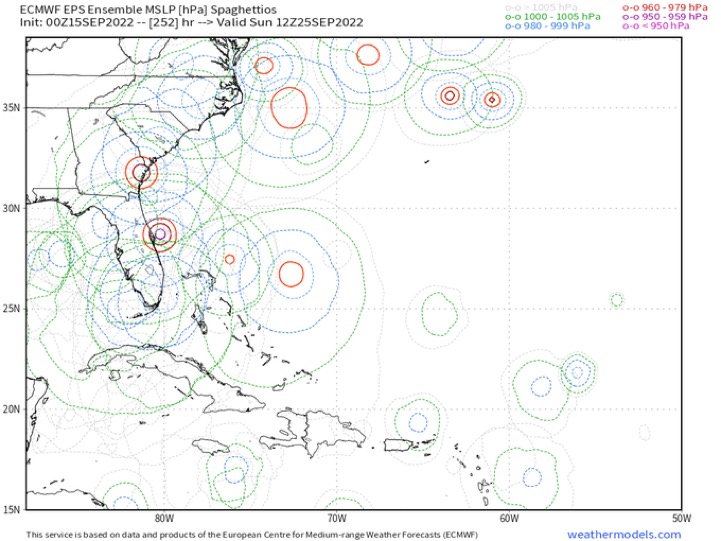
Euro trend is not in the right direction.


4 likes
M a r k
- - - - -
Join us in chat: Storm2K Chatroom Invite. Android and IOS apps also available.
The posts in this forum are NOT official forecasts and should not be used as such. Posts are NOT endorsed by any professional institution or STORM2K.org. For official information and forecasts, please refer to NHC and NWS products.

Re: ATL: FIONA - Models
The HWRF and HMON show such wildly different extremes compared to the operational global models. HWRF is further north and blows this up into a major in a few days, while the HMON is south of the model consensus and kills this over the Greater Antilles.
1 likes
Irene '11 Sandy '12 Hermine '16 5/15/2018 Derecho Fay '20 Isaias '20 Elsa '21 Henri '21 Ida '21
I am only a meteorology enthusiast who knows a decent amount about tropical cyclones. Look to the professional mets, the NHC, or your local weather office for the best information.
I am only a meteorology enthusiast who knows a decent amount about tropical cyclones. Look to the professional mets, the NHC, or your local weather office for the best information.
-
SFLcane
- S2K Supporter
- Posts: 10281
- Age: 48
- Joined: Sat Jun 05, 2010 1:44 pm
- Location: Lake Worth Florida
Re: ATL: FIONA - Models
0 likes
-
Blown Away

- S2K Supporter
- Posts: 10253
- Joined: Wed May 26, 2004 6:17 am
Re: ATL: FIONA - Models

00z

06z... Quite an uptick in intensity.
1 likes
Hurricane Eye Experience: David 79, Irene 99, Frances 04, Jeanne 04, Wilma 05… Hurricane Brush Experience: Andrew 92, Erin 95, Floyd 99, Matthew 16, Irma 17, Ian 22, Nicole 22…
Re: ATL: FIONA - Models
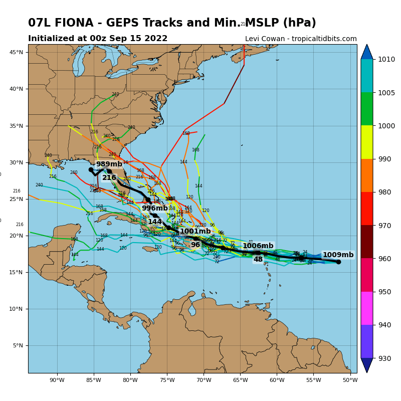
Tomer Burg has a lot of cool graphics for these models, this one below really shows the spread of the models here. Notable how large the spread is west to east even fairly soon in. before it tilts sw to ne. The graphic is based on the 12Z from yesterday, though. But if anything the spread is even more now.
http://arctic.som.ou.edu/tburg/products ... /tropical/

http://arctic.som.ou.edu/tburg/products ... /tropical/
Last edited by BobHarlem on Thu Sep 15, 2022 6:33 am, edited 2 times in total.
4 likes
-
Blown Away
- S2K Supporter
- Posts: 10253
- Joined: Wed May 26, 2004 6:17 am
Re: ATL: FIONA - Models
aspen wrote:The HWRF and HMON show such wildly different extremes compared to the operational global models. HWRF is further north and blows this up into a major in a few days, while the HMON is south of the model consensus and kills this over the Greater Antilles.

HMON 06z @66 hrs showing a hurricane for NE Caribbean,
0 likes
Hurricane Eye Experience: David 79, Irene 99, Frances 04, Jeanne 04, Wilma 05… Hurricane Brush Experience: Andrew 92, Erin 95, Floyd 99, Matthew 16, Irma 17, Ian 22, Nicole 22…
Re: ATL: SEVEN - Models
toad strangler wrote:caneman wrote:toad strangler wrote:
The overall pattern almost every single year in recorded history with systems in this spot is OTS. It’s the Atlantic Basin super highway. That’s the safest call to make at this juncture.
There is no safe call to make right now. It's too far out and some models have shifted West. Some taking it just South of the islands. Some keep it weaker and further West. There is no super highway OTS from just below the islands. And each storm and set up and timing is completely unique. I don't care if 90% of storms go out to sea. You don't know which will be the 10%.
It's less than 10% and you changed the context of my post. I was speaking of the spot Fiona was at THAT moment. Not from underneath the GA's. There is absolutely a climatological re-curve favored track east of the CONUS from that genearl area I was talking about. I see the 6z GFS does just that. Although in rather interesting fashion. We shall see!
I didn't change the context, you can't make an assumption from that point as OTS and as a "safe call". You also cant weight post analysis with current analysis especially when current analysis showed there is still a wide model spread over a long range. Sure, do 90% or a larger portion in that area go OTS YES but you never know when the 10% of so won't. This may well be that one. We don't know yet and even more models this morning go further West now. I don't trust any modeling outside of 120 hours.
0 likes
Re: ATL: FIONA - Models
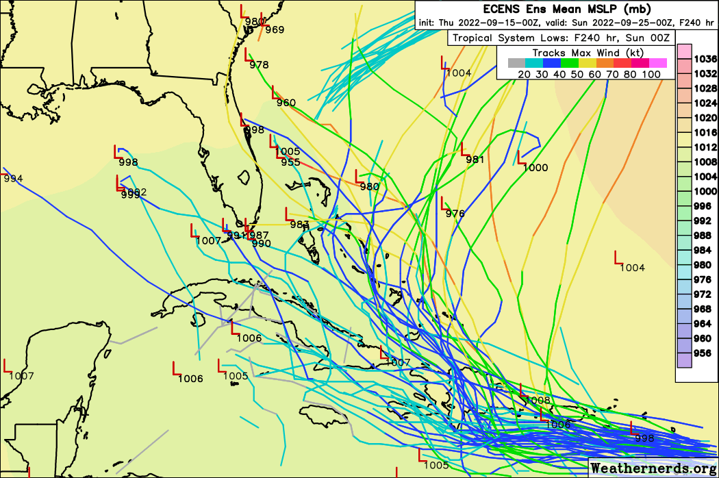
This really shows how the stronger/faster moving GFS members are recurving here (and if they did Bermuda is under the gun). Most of the slower/weaker ones are too, just further west (at least out to 180 hours, the bend back west of a few toward the end is going to be another one to watch even if it does turn right before/at the Bahamas), but the spread is pretty large. The Canadian ensembles look very different.

6z euro ensembles out to the last frame
 \
\
One thing to remember, just two days ago Tuesday's 6z gfs had NOTHING for where fiona is right now.
6z euro ensembles out to the last frame
\One thing to remember, just two days ago Tuesday's 6z gfs had NOTHING for where fiona is right now.
Last edited by BobHarlem on Thu Sep 15, 2022 7:03 am, edited 3 times in total.
2 likes
-
toad strangler
- S2K Supporter
- Posts: 4546
- Joined: Sun Jul 28, 2013 3:09 pm
- Location: Earth
- Contact:
Re: ATL: SEVEN - Models
caneman wrote:toad strangler wrote:caneman wrote:
There is no safe call to make right now. It's too far out and some models have shifted West. Some taking it just South of the islands. Some keep it weaker and further West. There is no super highway OTS from just below the islands. And each storm and set up and timing is completely unique. I don't care if 90% of storms go out to sea. You don't know which will be the 10%.
It's less than 10% and you changed the context of my post. I was speaking of the spot Fiona was at THAT moment. Not from underneath the GA's. There is absolutely a climatological re-curve favored track east of the CONUS from that genearl area I was talking about. I see the 6z GFS does just that. Although in rather interesting fashion. We shall see!
I didn't change the context, you can't make an assumption from that point as OTS and as a "safe call". You also cant weight post analysis with current analysis especially when current analysis showed there is still a wide model spread over a long range. Sure, do 90% or a larger portion in that area go OTS YES but you never know when the 10% of so won't. This may well be that one. We don't know yet and even more models this morning go further West now. I don't trust any modeling outside of 120 hours.
I wasn't making a personal call, I was responding to others making that OTS call and saying, yeah, that's the safe way to go if you are making a call now. You don't trust models outside of 120 hours? I don't trust them outside of 72.
Obviously there is no confidence ATM on any solution post Lesser A's.
3 likes
My Weather Station
https://www.wunderground.com/dashboard/pws/KFLPORTS603
https://www.wunderground.com/dashboard/pws/KFLPORTS603
Who is online
Users browsing this forum: No registered users and 46 guests