ATL: IAN - Models
Moderator: S2k Moderators
-
gatorcane

- S2K Supporter

- Posts: 23708
- Age: 48
- Joined: Sun Mar 13, 2005 3:54 pm
- Location: Boca Raton, FL
Re: ATL: IAN - Models
Looks to be trying to turn NNE at hour 96. BIG change on the GFS.
Last edited by gatorcane on Sun Sep 25, 2022 11:02 am, edited 2 times in total.
3 likes
-
tolakram
- Admin

- Posts: 20186
- Age: 62
- Joined: Sun Aug 27, 2006 8:23 pm
- Location: Florence, KY (name is Mark)
Re: ATL: IAN - Models
toad strangler wrote:tolakram wrote:Moving north now, GFS is not giving up on Ian getting pulled but then missing the trough.
https://i.imgur.com/XzwLJKQ.png
Looking at 500mb the trough is a bit slower in pulling out. It's lagging back a bit.
The easiest answer at this point is where it crosses into the Gulf. The Euro and GFS are not that far off. If it gets west of Cuba it goes further north, crosses Cuba further east. Seems pretty straightforward, just wish we knew right now who is going to get the crossing right.
3 likes
M a r k
- - - - -
Join us in chat: Storm2K Chatroom Invite. Android and IOS apps also available.
The posts in this forum are NOT official forecasts and should not be used as such. Posts are NOT endorsed by any professional institution or STORM2K.org. For official information and forecasts, please refer to NHC and NWS products.
-
chris_fit

- Category 5

- Posts: 3261
- Age: 43
- Joined: Wed Sep 10, 2003 11:58 pm
- Location: Tampa Bay Area, FL
Re: ATL: IAN - Models
gatorcane wrote:Looks to be turn NNE at hour 96. BIG change on the GFS.
Trend...

6 likes
-
tolakram
- Admin
- Posts: 20186
- Age: 62
- Joined: Sun Aug 27, 2006 8:23 pm
- Location: Florence, KY (name is Mark)
Re: ATL: IAN - Models

2 likes
M a r k
- - - - -
Join us in chat: Storm2K Chatroom Invite. Android and IOS apps also available.
The posts in this forum are NOT official forecasts and should not be used as such. Posts are NOT endorsed by any professional institution or STORM2K.org. For official information and forecasts, please refer to NHC and NWS products.
- - - - -
Join us in chat: Storm2K Chatroom Invite. Android and IOS apps also available.
The posts in this forum are NOT official forecasts and should not be used as such. Posts are NOT endorsed by any professional institution or STORM2K.org. For official information and forecasts, please refer to NHC and NWS products.

Re: ATL: IAN - Models
This is a good 60 mile shift to the right by the GFS compared to the 06z run, and a good 100-120 miles from the oz run.

4 likes

Re: ATL: IAN - Models
A bit more east - yes. We can't lose sight of one other thing here too. Look at that GFS "prior forecast -to current" loop that you attached. Notice how the new 12Z GFS suggests a further north latitude then prior GFS runs? At least for the moment, GFS has sped up the time frame slightly with Ian reaching the latitude of the Western tip of Cuba as well. Whether or not this verifies remains to be seen however this northward and eastward nudging of forecast track bring the GFS closer in line with the EURO (and ICON). Disregard where NAM suggests landfall (and intensity) however do heed that model's broader scale CONUS mid/upper-level forecast and forecast trends.
Last edited by chaser1 on Sun Sep 25, 2022 11:11 am, edited 1 time in total.
2 likes
Andy D
(For official information, please refer to the NHC and NWS products.)
(For official information, please refer to the NHC and NWS products.)
-
tolakram
- Admin
- Posts: 20186
- Age: 62
- Joined: Sun Aug 27, 2006 8:23 pm
- Location: Florence, KY (name is Mark)
Re: ATL: IAN - Models
trend

2 likes
M a r k
- - - - -
Join us in chat: Storm2K Chatroom Invite. Android and IOS apps also available.
The posts in this forum are NOT official forecasts and should not be used as such. Posts are NOT endorsed by any professional institution or STORM2K.org. For official information and forecasts, please refer to NHC and NWS products.
- - - - -
Join us in chat: Storm2K Chatroom Invite. Android and IOS apps also available.
The posts in this forum are NOT official forecasts and should not be used as such. Posts are NOT endorsed by any professional institution or STORM2K.org. For official information and forecasts, please refer to NHC and NWS products.

Re: ATL: IAN - Models
tolakram wrote:toad strangler wrote:tolakram wrote:Moving north now, GFS is not giving up on Ian getting pulled but then missing the trough.
https://i.imgur.com/XzwLJKQ.png
Looking at 500mb the trough is a bit slower in pulling out. It's lagging back a bit.
The easiest answer at this point is where it crosses into the Gulf. The Euro and GFS are not that far off. If it gets west of Cuba it goes further north, crosses Cuba further east. Seems pretty straightforward, just wish we knew right now who is going to get the crossing right.
It looks as if the longer it stays in the gulf, the better it is for all Florida residents. Like I said, it's the 18Z models that will determine my next course of action.
2 likes

-
eastcoastFL

- Category 5
- Posts: 3996
- Age: 44
- Joined: Thu Apr 12, 2007 12:29 pm
- Location: Palm City, FL
Re: ATL: IAN - Models
tolakram wrote:toad strangler wrote:tolakram wrote:Moving north now, GFS is not giving up on Ian getting pulled but then missing the trough.
https://i.imgur.com/XzwLJKQ.png
Looking at 500mb the trough is a bit slower in pulling out. It's lagging back a bit.
The easiest answer at this point is where it crosses into the Gulf. The Euro and GFS are not that far off. If it gets west of Cuba it goes further north, crosses Cuba further east. Seems pretty straightforward, just wish we knew right now who is going to get the crossing right.
That’s going to be the million dollar question. Gfs has it going right off that western tip along the channel while the euro is a little bit east of it crossing over more of western Cuba. That little piece of the puzzle might be the game changer.
1 likes
Personal Forecast Disclaimer:
The posts in this forum are NOT official forecast and should not be used as such. They are just the opinion of the poster and may or may not be backed by sound meteorological data. They are NOT endorsed by any professional institution or storm2k.org. For official information, please refer to the NHC and NWS products.
The posts in this forum are NOT official forecast and should not be used as such. They are just the opinion of the poster and may or may not be backed by sound meteorological data. They are NOT endorsed by any professional institution or storm2k.org. For official information, please refer to the NHC and NWS products.
-
tolakram
- Admin
- Posts: 20186
- Age: 62
- Joined: Sun Aug 27, 2006 8:23 pm
- Location: Florence, KY (name is Mark)
Re: ATL: IAN - Models
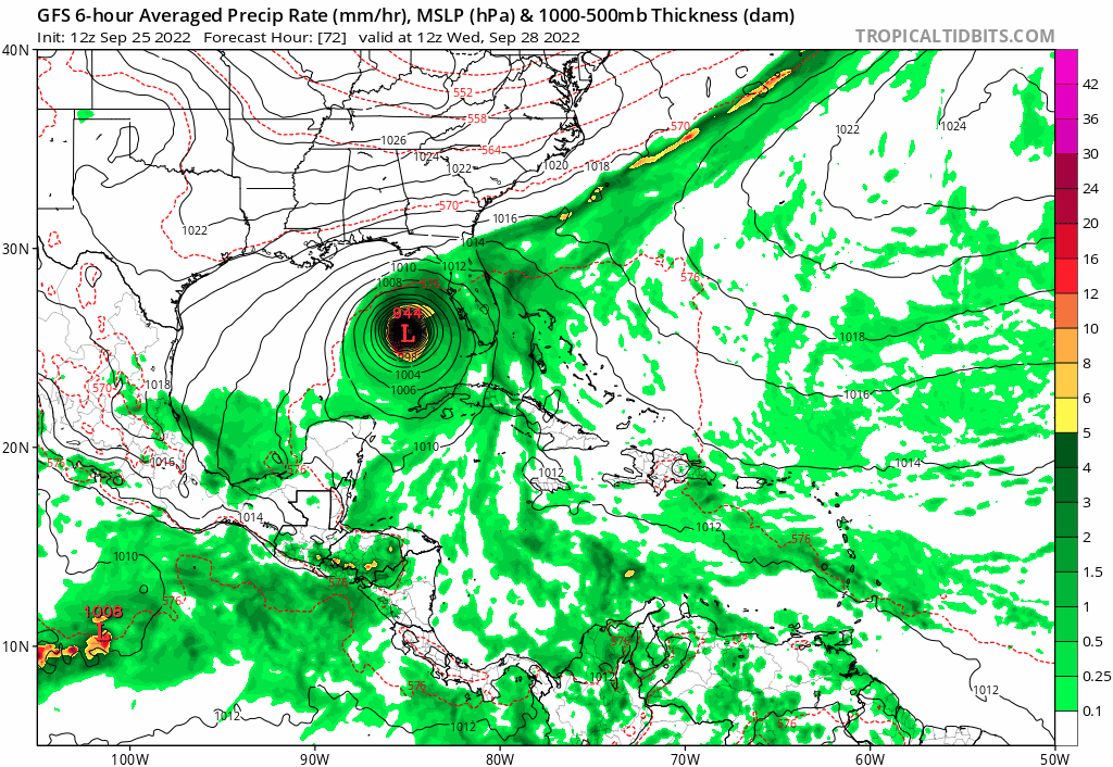
12Z GFS

1 likes
M a r k
- - - - -
Join us in chat: Storm2K Chatroom Invite. Android and IOS apps also available.
The posts in this forum are NOT official forecasts and should not be used as such. Posts are NOT endorsed by any professional institution or STORM2K.org. For official information and forecasts, please refer to NHC and NWS products.
- - - - -
Join us in chat: Storm2K Chatroom Invite. Android and IOS apps also available.
The posts in this forum are NOT official forecasts and should not be used as such. Posts are NOT endorsed by any professional institution or STORM2K.org. For official information and forecasts, please refer to NHC and NWS products.
Re: ATL: IAN - Models
Not until I see the Euro start trending to the left towards the official track will I say that the NHC track is good in the 3-5 day range.
2 likes
-
eastcoastFL
- Category 5
- Posts: 3996
- Age: 44
- Joined: Thu Apr 12, 2007 12:29 pm
- Location: Palm City, FL
Re: ATL: IAN - Models
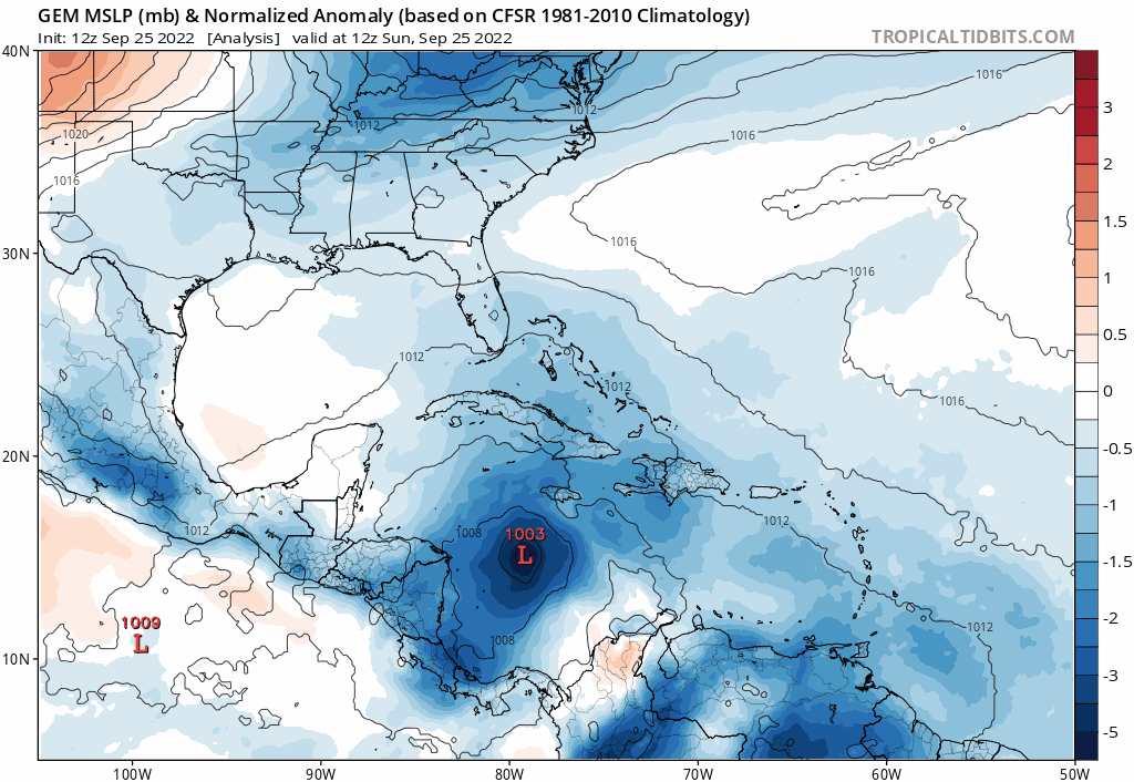
gatorcane wrote:12Z CMC turning NE a bit more south of the 00Z:
https://i.postimg.cc/y8qkJV1t/gem-mslpa-Norm-watl-fh0-72.gif
Not a great trend especially after seeing the UKMET
1 likes
Personal Forecast Disclaimer:
The posts in this forum are NOT official forecast and should not be used as such. They are just the opinion of the poster and may or may not be backed by sound meteorological data. They are NOT endorsed by any professional institution or storm2k.org. For official information, please refer to the NHC and NWS products.
The posts in this forum are NOT official forecast and should not be used as such. They are just the opinion of the poster and may or may not be backed by sound meteorological data. They are NOT endorsed by any professional institution or storm2k.org. For official information, please refer to the NHC and NWS products.
-
eastcoastFL
- Category 5
- Posts: 3996
- Age: 44
- Joined: Thu Apr 12, 2007 12:29 pm
- Location: Palm City, FL
Re: ATL: IAN - Models
ICON 12z looks like it’s around Tampa

2 likes
Personal Forecast Disclaimer:
The posts in this forum are NOT official forecast and should not be used as such. They are just the opinion of the poster and may or may not be backed by sound meteorological data. They are NOT endorsed by any professional institution or storm2k.org. For official information, please refer to the NHC and NWS products.
The posts in this forum are NOT official forecast and should not be used as such. They are just the opinion of the poster and may or may not be backed by sound meteorological data. They are NOT endorsed by any professional institution or storm2k.org. For official information, please refer to the NHC and NWS products.
-
ConvergenceZone
.gif)
- Category 5
- Posts: 5241
- Joined: Fri Jul 29, 2005 1:40 am
- Location: Northern California
Re: ATL: IAN - Models
I know that the flooding can be really bad, but I think we should all be grateful of the amount of shear that's forecasted to be in the northern gulf.... I can't even imagine how horrible this situation would have been if the conditions were great for intensification, rather than weakening. Cat 1 to maybe Cat 2 seems the most likely strength at landfall... .. I'm not really concerned about the wind as much though, except on the coast... I'm concerned about the rain/surge, especially if the EURO wins out and there's more of a stall over Florida......
Last edited by ConvergenceZone on Sun Sep 25, 2022 11:20 am, edited 1 time in total.
3 likes
-
toad strangler

- S2K Supporter
- Posts: 4546
- Joined: Sun Jul 28, 2013 3:09 pm
- Location: Earth
- Contact:
Re: ATL: IAN - Models
CMC into the armpit of the Big Bend
2 likes
My Weather Station
https://www.wunderground.com/dashboard/pws/KFLPORTS603
https://www.wunderground.com/dashboard/pws/KFLPORTS603

Re: ATL: IAN - Models
gatorcane wrote:12Z CMC turning NE a bit more south of the 00Z:
https://i.postimg.cc/y8qkJV1t/gem-mslpa-Norm-watl-fh0-72.gif
AND..... this morning's 12Z CMC is also further north compared to yesterday's 12Z run as well.
1 likes
Andy D
(For official information, please refer to the NHC and NWS products.)
(For official information, please refer to the NHC and NWS products.)
-
eastcoastFL
- Category 5
- Posts: 3996
- Age: 44
- Joined: Thu Apr 12, 2007 12:29 pm
- Location: Palm City, FL
Re: ATL: IAN - Models
toad strangler wrote:CMC into the armpit of the Big Bend
What’s also kinda scary is they all seem to go from a NE heading to a N or NNE. So depending on how far it comes into the state it could potentially run right up the center of the state when it turns back to the north.
1 likes
Personal Forecast Disclaimer:
The posts in this forum are NOT official forecast and should not be used as such. They are just the opinion of the poster and may or may not be backed by sound meteorological data. They are NOT endorsed by any professional institution or storm2k.org. For official information, please refer to the NHC and NWS products.
The posts in this forum are NOT official forecast and should not be used as such. They are just the opinion of the poster and may or may not be backed by sound meteorological data. They are NOT endorsed by any professional institution or storm2k.org. For official information, please refer to the NHC and NWS products.
Who is online
Users browsing this forum: No registered users and 37 guests